Geodha Mòr Campaigh

Coastal Feature, Headland, Point in Ross-shire

Scotland

Geodha Mòr Campaigh

Beehive Cell - Eilean Fir Chrothair The beautiful little beehive cell on the island of Eilean Fir Chrothair.
Beehive Cell - Eilean Fir Chrothair Credit: Marc Calhoun

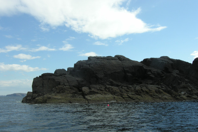
Geodha Mòr Campaigh is a stunning coastal feature located in Ross-shire, Scotland. It is a headland that extends out into the North Atlantic Ocean, forming a prominent point along the rugged coastline.

The headland is characterized by towering cliffs that rise dramatically from the sea, providing breathtaking views of the surrounding landscape. These cliffs are composed of ancient rocks, showcasing layers of sedimentary deposits that have been shaped by millions of years of geological processes.

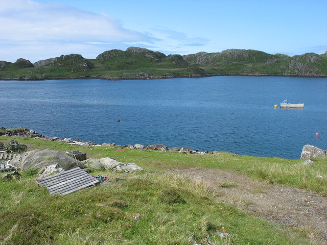
Geodha Mòr Campaigh is renowned for its natural beauty and is a popular destination for nature enthusiasts, hikers, and photographers. The area offers a diverse range of habitats, including rocky shores, sandy beaches, and grassy meadows, which support a rich variety of plant and animal species.

Visitors to Geodha Mòr Campaigh can explore the headland by following well-maintained walking trails that wind their way along the cliffs. Along the way, they may encounter seabird colonies, such as gannets and puffins, nesting on the cliffs, adding to the area's charm and appeal.

The headland also boasts a fascinating history, with remnants of ancient settlements and archaeological sites that date back thousands of years. These remnants provide insights into the lives of the people who once inhabited this coastal region.

Overall, Geodha Mòr Campaigh is a captivating coastal feature that showcases the raw power of nature and offers a unique blend of natural beauty, wildlife, and historical significance. It is a must-visit destination for anyone seeking to experience the awe-inspiring landscapes of Ross-shire.

If you have any feedback on the listing, please let us know in the comments section below.

Geodha Mòr Campaigh Images

Images are sourced within 2km of 58.279822/-6.8745111 or Grid Reference NB1442. Thanks to Geograph Open Source API. All images are credited.

Beehive Cell - Eilean Fir Chrothair The beautiful little beehive cell on the island of Eilean Fir Chrothair.
Beehive Cell - Eilean Fir Chrothair
The beautiful little beehive cell on the island of Eilean Fir Chrothair.
Lunch stop on Little Bernera Although well under halfway round our trip exploring sea caves in the islands north of Great Bernera, this would be the last sandy beach offering an easy landing, so a stop was inevitable, if only to stretch the legs and relieve any undue pressure. The sea here is deceptively calm - out on the rocky coasts there was an interesting level of swell, which always makes sea cave exploration "interesting".
Lunch stop on Little Bernera
Although well under halfway round our trip exploring sea caves in the islands north of Great Bernera, this would be the last sandy beach offering an easy landing, so a stop was inevitable, if only to stretch the legs and relieve any undue pressure. The sea here is deceptively calm - out on the rocky coasts there was an interesting level of swell, which always makes sea cave exploration "interesting".
Passing through the cave under Campaigh The large scale OS map shows a "natural arch" right through the island of Campaigh, and from either end, one can see daylight on the other side. When explored, however, one finds that there is a third entrance, which must emerge on the north coast of the island. Unfortunately the passage is so narrow and hading that a kayak cannot get through whatever the state of the tide. Daylight, however, is clearly visible, and perhaps a brave enough swimmer/climber could make their way in or out that way (you'd want a day with very little swell as the water surges up and down quite a bit in the middle of the cave).
Passing through the cave under Campaigh
The large scale OS map shows a "natural arch" right through the island of Campaigh, and from either end, one can see daylight on the other side. When explored, however, one finds that there is a third entrance, which must emerge on the north coast of the island. Unfortunately the passage is so narrow and hading that a kayak cannot get through whatever the state of the tide. Daylight, however, is clearly visible, and perhaps a brave enough swimmer/climber could make their way in or out that way (you'd want a day with very little swell as the water surges up and down quite a bit in the middle of the cave).
The eastern entrance of the cave under Campaigh One of the UK's longer through-passage sea caves, much more significant than indicated by the OS map's "natural arch", the route under Campaigh actually has three connections to the outside world. Kayakers can readily pass (in suitable sea conditions) from/to the open east (seen here) and west entrances which connect along a straight passage, so daylight can be seen right the way through. Midway, there is a skylight through a hading rift to the north coast - not passable by a boat of any size at any state of the tide.
The eastern entrance of the cave under Campaigh
One of the UK's longer through-passage sea caves, much more significant than indicated by the OS map's "natural arch", the route under Campaigh actually has three connections to the outside world. Kayakers can readily pass (in suitable sea conditions) from/to the open east (seen here) and west entrances which connect along a straight passage, so daylight can be seen right the way through. Midway, there is a skylight through a hading rift to the north coast - not passable by a boat of any size at any state of the tide.
Rock-hopping through skerries between Little Bernera and Gaisgeir Coming round the east side of Little Bernera on a day trip out from Bostadh, we have already poked into our first cave of the day just to the south, and are now dodging between skerries as we enter water with a bit less shelter form today's westerly swell. This particular little channel appears to be above high water on every scale of OS mapping, but is easily wide enough for a narrow-beamed (and highly manoeuvrable) boat like a sea kayak.
Rock-hopping through skerries between Little Bernera and Gaisgeir
Coming round the east side of Little Bernera on a day trip out from Bostadh, we have already poked into our first cave of the day just to the south, and are now dodging between skerries as we enter water with a bit less shelter form today's westerly swell. This particular little channel appears to be above high water on every scale of OS mapping, but is easily wide enough for a narrow-beamed (and highly manoeuvrable) boat like a sea kayak.
Traigh Mhor, Isle of Little Bernera Traigh Mhor, a wide shell-sand beach on the north shore of Little Bernera. Gealachos (Fair-Foot) must have enjoyed swimming here. Refer to Donald Macdonald’s 'The Lews' for the legend of Gealachos of Little Berneray. 
And if you do, you'll discover how William Black made use of her legend in his novel 'The Princess of Thule'.
Traigh Mhor, Isle of Little Bernera
Traigh Mhor, a wide shell-sand beach on the north shore of Little Bernera. Gealachos (Fair-Foot) must have enjoyed swimming here. Refer to Donald Macdonald’s 'The Lews' for the legend of Gealachos of Little Berneray. And if you do, you'll discover how William Black made use of her legend in his novel 'The Princess of Thule'.
North face of Mas Sgeir This outlier of Lewisian Gneiss is a superb dive with a huge variety of species including the Red Blenny.
North face of Mas Sgeir
This outlier of Lewisian Gneiss is a superb dive with a huge variety of species including the Red Blenny.
Sgeir Dhearg, Poll Gainmhich This low lying skerry, of Lewisian Gneiss, is split in two. In the distance, Mas Sgeir can be seen through the gap.
Sgeir Dhearg, Poll Gainmhich
This low lying skerry, of Lewisian Gneiss, is split in two. In the distance, Mas Sgeir can be seen through the gap.
Natural arch through Campaigh Half way along the tunnel through Campaigh a second passage heads in a North-west direction forming a second, smaller natural arch. Many Grey Atlantic seals inhabit the tunnels.
Natural arch through Campaigh
Half way along the tunnel through Campaigh a second passage heads in a North-west direction forming a second, smaller natural arch. Many Grey Atlantic seals inhabit the tunnels.
Un-named lochan, Bearnaraigh Beag From Creag Ghrodaig, the view of this un-named lochan is superb, spoilt only by the wind and sea driven litter.
Un-named lochan, Bearnaraigh Beag
From Creag Ghrodaig, the view of this un-named lochan is superb, spoilt only by the wind and sea driven litter.
Caolas Cealasaigh, Bearnaraigh Beag A shell sand beach along the North coast of Bearnaraigh Beag. The skerry in the middle of the photograph is called Sgeir a' Mhurain.
Caolas Cealasaigh, Bearnaraigh Beag
A shell sand beach along the North coast of Bearnaraigh Beag. The skerry in the middle of the photograph is called Sgeir a' Mhurain.
Little Bernera This view of Little Bernera (Bearnaraigh Beag) is taken from the northern shore of Great Bernera (Bearnaraigh).
Little Bernera
This view of Little Bernera (Bearnaraigh Beag) is taken from the northern shore of Great Bernera (Bearnaraigh).
Show me another place!

Geodha Mòr Campaigh is located at Grid Ref: NB1442 (Lat: 58.279822, Lng: -6.8745111)

Unitary Authority: Na h-Eileanan an Iar

Police Authority: Highlands and Islands

What 3 Words

///angel.salon.cleanser. Near Carloway, Na h-Eileanan Siar

Related Wikis

Campaigh

Campaigh or Campay is a steep and rocky islet in outer Loch Ròg, Lewis, Scotland that lies north of Cealasaigh and Little Bernera. A huge natural arch...

Cealasaigh

Cealasaigh or Kealasay is an islet in outer Loch Ròg, Lewis, Scotland that lies north of Traigh Mhór on Little Bernera and south of Campaigh. To the west...

Little Bernera

Little Bernera (Scottish Gaelic: Beàrnaraigh Beag) is a small island situated off the west coast of the Isle of Lewis in the Outer Hebrides. Little Bernera...

Bearasaigh

Bearasaigh or Bearasay (and sometimes Berisay) is an islet in outer Loch Ròg, Lewis, Scotland. During the late 16th and early 17th centuries it was used...

Have you been to Geodha Mòr Campaigh?

Leave your review of Geodha Mòr Campaigh below (or comments, questions and feedback).