Gob na Muce

Coastal Feature, Headland, Point in Inverness-shire

Scotland

Gob na Muce

Dùn from Ruabhal A classic view of Dùn.  I had a memorable day on Dùn not helped by falling into the sea when being landed.  It is lucky my camera survived to take these images later.
Dùn from Ruabhal Credit: Julian Paren

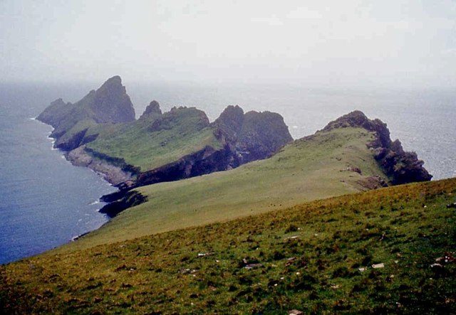
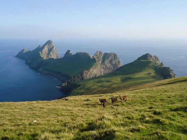
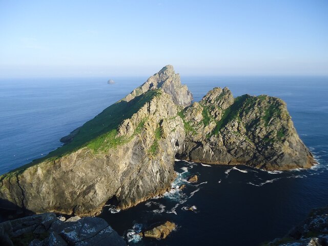
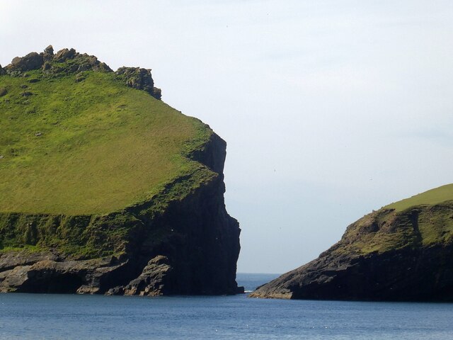
Gob na Muce is a prominent coastal feature located in Inverness-shire, Scotland. It is specifically categorized as a headland or point, protruding into the sea and offering breathtaking views of the surrounding landscape.

Situated on the west coast of Scotland, Gob na Muce is known for its rugged beauty and dramatic cliffs that rise majestically from the Atlantic Ocean. The headland is characterized by its steep slopes, which are covered in lush green vegetation, creating a stark contrast against the deep blue waters below.

Gob na Muce is a popular destination for nature enthusiasts, hikers, and photographers looking to explore the stunning Scottish coastline. The headland offers a variety of walking trails, allowing visitors to immerse themselves in the region's natural beauty. The paths wind through heather-covered moorland, offering panoramic views of the surrounding sea and nearby islands.

The area is also home to a diverse range of wildlife, including seabirds such as gannets, puffins, and guillemots. Visitors may also spot seals basking on the rocks or dolphins playing in the waves.

Gob na Muce is easily accessible by road, with a car park located nearby, providing a convenient starting point for those wishing to explore the headland. The site is well-maintained, and various viewpoints and picnic areas are available, allowing visitors to fully appreciate the stunning scenery.

In summary, Gob na Muce is a picturesque headland located in Inverness-shire, Scotland. With its impressive cliffs, breathtaking views, and abundant wildlife, it is a must-visit destination for nature lovers and outdoor enthusiasts.

If you have any feedback on the listing, please let us know in the comments section below.

Gob na Muce Images

Images are sourced within 2km of 57.793999/-8.5513966 or Grid Reference NF1097. Thanks to Geograph Open Source API. All images are credited.

Dùn from Ruabhal A classic view of Dùn.  I had a memorable day on Dùn not helped by falling into the sea when being landed.  It is lucky my camera survived to take these images later.
Dùn from Ruabhal
A classic view of Dùn. I had a memorable day on Dùn not helped by falling into the sea when being landed. It is lucky my camera survived to take these images later.
Village Bay from the side of Ruabhal, Hirta The military encampment is noticeable and this image was taken when the North Uist Rocket Range was extensively used by NATO.
Village Bay from the side of Ruabhal, Hirta
The military encampment is noticeable and this image was taken when the North Uist Rocket Range was extensively used by NATO.
Below The Mistress Stone, St Kilda This stone shared with The Lovers Stone a role in proving fidelity in courtship. Village Bay, Hirta is in the background.
Below The Mistress Stone, St Kilda
This stone shared with The Lovers Stone a role in proving fidelity in courtship. Village Bay, Hirta is in the background.
Dùn and Hirta A view along the coast of Dùn towards Ruabhal, on the island of Hirta, and the narrow strait (Caolas an Dùin) which separates the two islands. View taken from Bhàga a’ Bhaile (Village Bay).
Dùn and Hirta
A view along the coast of Dùn towards Ruabhal, on the island of Hirta, and the narrow strait (Caolas an Dùin) which separates the two islands. View taken from Bhàga a’ Bhaile (Village Bay).
Dùn from Ruabhal
Dùn from Ruabhal
Ruabhal and Dun
Ruabhal and Dun
The island of Dun Seen from about the most southerly point of Hirta. In the distance the skerry called Leibhinis <a href="https://www.geograph.org.uk/gridref/NF1396">NF1396</a> can be seen.
The island of Dun
Seen from about the most southerly point of Hirta. In the distance the skerry called Leibhinis NF1396 can be seen.
St Kilda - Caolas an Dùin (the straits of Dùn) The island of Dùn is almost joined to Hirta at Ruiaval, however the two islands are separated by Caolas an Dùin (the straits of Dùn) which can be seen here with Dùn on the left. This small separation meant (and means) that the Soay sheep that roam freely on Hirta do not live on Dùn.
A short but useful Wikipedia entry on Dùn here <span class="nowrap"><a title="https://en.wikipedia.org/wiki/D%C3%B9n" rel="nofollow ugc noopener" href="https://en.wikipedia.org/wiki/D%C3%B9n">Link</a><img style="margin-left:2px;" alt="External link" title="External link - shift click to open in new window" src="https://s1.geograph.org.uk/img/external.png" width="10" height="10"/></span>
St Kilda - Caolas an Dùin (the straits of Dùn)
The island of Dùn is almost joined to Hirta at Ruiaval, however the two islands are separated by Caolas an Dùin (the straits of Dùn) which can be seen here with Dùn on the left. This small separation meant (and means) that the Soay sheep that roam freely on Hirta do not live on Dùn. A short but useful Wikipedia entry on Dùn here LinkExternal link
Yachts in Village Bay, St Kilda With Ruabhal as the backdrop.
Yachts in Village Bay, St Kilda
With Ruabhal as the backdrop.
Rubhal from the pier at Village Bay, St Kilda In the foreground is the boat that brought us across, Orca II operated by kildacruises.co.uk.
Rubhal from the pier at Village Bay, St Kilda
In the foreground is the boat that brought us across, Orca II operated by kildacruises.co.uk.
Giasgeir and Caolas an Duin, St Kilda There are the remains of cultivation on Dun from when it was still connected to Hirta, and early visitors to St Kilda describe how it was possible to skip across the rocks at low tide, but this not advisable these days.
Giasgeir and Caolas an Duin, St Kilda
There are the remains of cultivation on Dun from when it was still connected to Hirta, and early visitors to St Kilda describe how it was possible to skip across the rocks at low tide, but this not advisable these days.
Ruabhal, St Kilda Bagged on a circuit of six Hirta TUMPs on a sunny afternoon.
Name: Ruabhal
Hill number: 12797
Height: 130m / 427ft
Parent (Ma/M): 1636 Conachair
Section: 25: St Kilda
County/UA: Na h-Eileanan Siar [Western Isles] (UA)
Island: Hirta
Class: Tump (100-199m)
Grid ref: NF 09577 97873
Summit feature: rocky tor
Drop: 32m
Col: 98m NF095980
Ruabhal, St Kilda
Bagged on a circuit of six Hirta TUMPs on a sunny afternoon. Name: Ruabhal Hill number: 12797 Height: 130m / 427ft Parent (Ma/M): 1636 Conachair Section: 25: St Kilda County/UA: Na h-Eileanan Siar [Western Isles] (UA) Island: Hirta Class: Tump (100-199m) Grid ref: NF 09577 97873 Summit feature: rocky tor Drop: 32m Col: 98m NF095980
Southernmost point of Hirta island Forbidding coastline seen from a cruise liner.
Southernmost point of Hirta island
Forbidding coastline seen from a cruise liner.
The gap between Hirta and Dun Dun on the left, Hirta on the right separated by Caolas an Duin.
The gap between Hirta and Dun
Dun on the left, Hirta on the right separated by Caolas an Duin.
Ruabhal Looking down the ridge of Ruabhal towards the island of Dun.
Ruabhal
Looking down the ridge of Ruabhal towards the island of Dun.
The Mistress Stone A balanced stone arch above a drop. It has a similar story to the Lover's Stone.
<a href="https://www.geograph.org.uk/photo/4574320">NF0899 : Lover's Stone</a>
The Mistress Stone
A balanced stone arch above a drop. It has a similar story to the Lover's Stone. NF0899 : Lover's Stone
The gap between Hirta and Dun The two islands in the St Kilda archipelago are separated by just this small channel. Tricky to cross though!
The gap between Hirta and Dun
The two islands in the St Kilda archipelago are separated by just this small channel. Tricky to cross though!
Sea cave on Hirta Taken as we leave Village Bay, round to the left.
Sea cave on Hirta
Taken as we leave Village Bay, round to the left.
Show me another place!

Gob na Muce is located at Grid Ref: NF1097 (Lat: 57.793999, Lng: -8.5513966)

Unitary Authority: Na h-Eileanan an Iar

Police Authority: Highlands and Islands

What 3 Words

///cookie.club.spokes. Near Balivanich, Na h-Eileanan Siar

Related Wikis

Dùn

Dùn is an island in St Kilda, Scotland. It is nearly 1 mile (1.6 kilometres) long. Its name simply means "fort" in Scottish Gaelic (for more information...

Stac Levenish

Stac Levenish or Stac Leibhinis (sometimes simply called Levenish/Leibhinis) is a sea stack in the St Kilda archipelago in Scotland. Lying 2.5 kilometres...

Hirta

Hirta (Scottish Gaelic: Hiort) is the largest island in the St Kilda archipelago, on the western edge of Scotland. The names Hiort (in Scottish Gaelic...

St Kilda, Scotland

St Kilda (Scottish Gaelic: Hiort) is an isolated archipelago situated 64 kilometres (40 mi) west-northwest of North Uist in the North Atlantic Ocean. It...

Have you been to Gob na Muce?

Leave your review of Gob na Muce below (or comments, questions and feedback).