Tanner's Creek

Sea, Estuary, Creek in Hampshire

England

Tanner's Creek

Containers beside Eling Creek The wharf is no longer active - this container store is serviced by road.
Containers beside Eling Creek Credit: David Martin

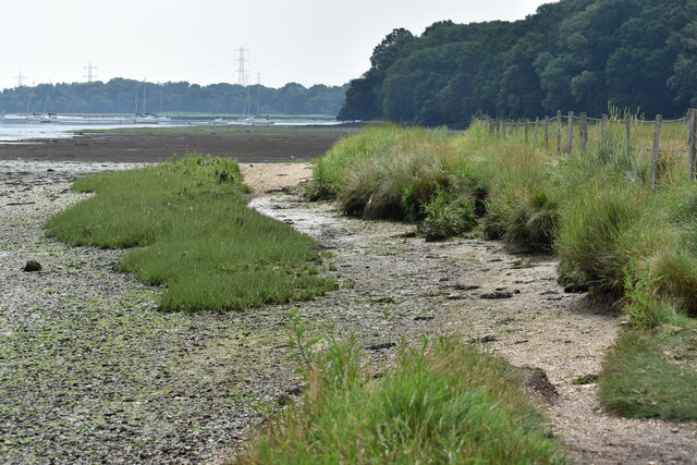
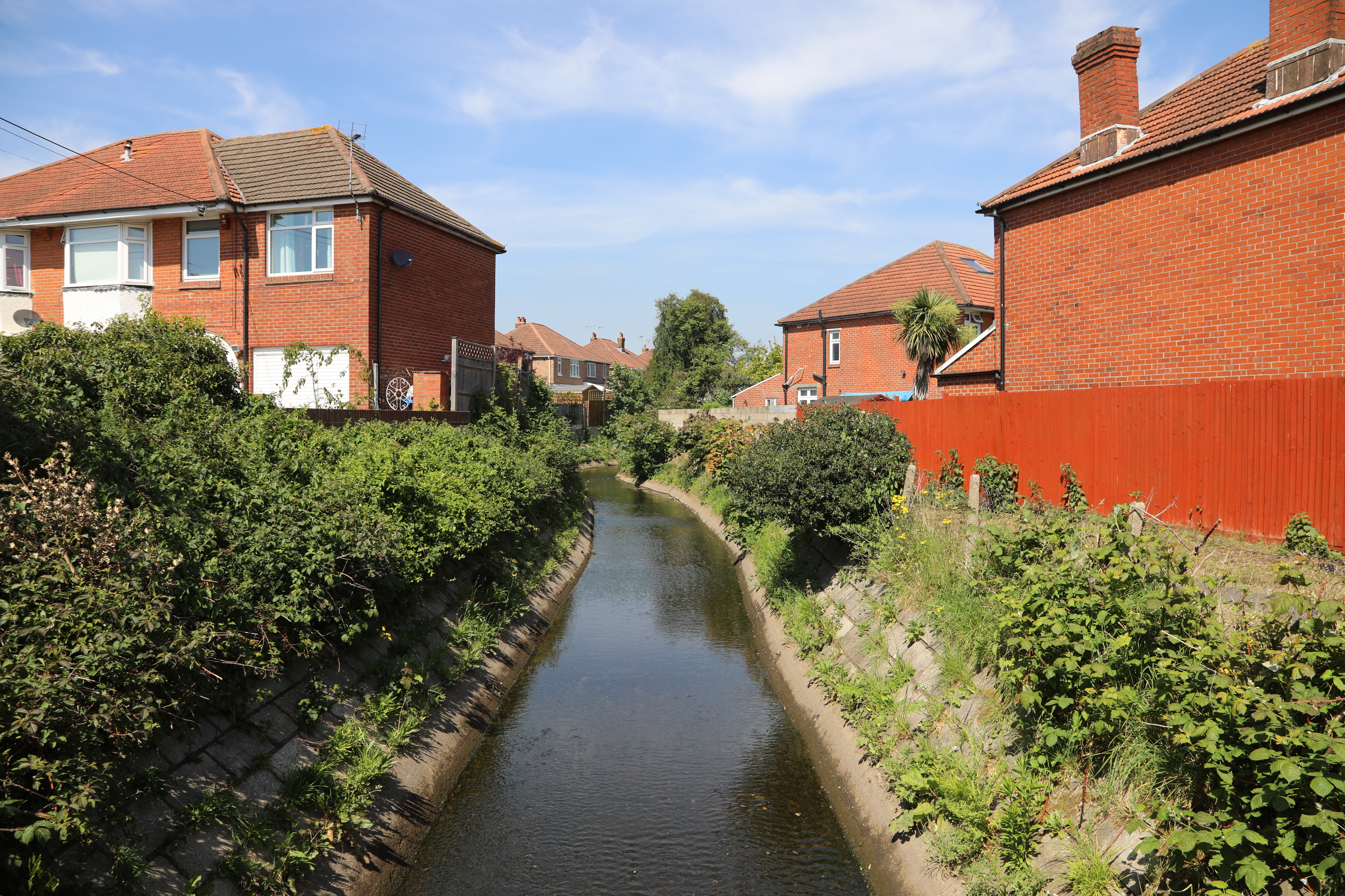
Tanner's Creek is a picturesque waterway located in Hampshire, England. It is an estuary that eventually flows into the sea, making it a significant natural feature in the area. The creek stretches for approximately 4 miles and is surrounded by lush greenery and diverse wildlife.

The creek serves as an important habitat for various species of plants and animals. The surrounding marshes and mudflats are home to a wide range of bird species, including herons, egrets, and various migratory birds. The creek also supports a variety of fish, such as sea trout and flounder, making it a popular spot for fishing enthusiasts.

Tanner's Creek is a haven for nature lovers and outdoor enthusiasts. It offers a tranquil and serene environment, perfect for leisurely walks or birdwatching. The creek's tidal nature provides a unique experience as the water levels rise and fall throughout the day, creating an ever-changing landscape.

The surrounding area of Tanner's Creek is also rich in history and culture. Nearby villages and towns showcase traditional Hampshire architecture and offer charming pubs and cafes. The creek itself has been an important trade route for centuries, with remnants of old wharfs and boatyards still visible along its banks.

Overall, Tanner's Creek is a beautiful and diverse natural feature that provides a sanctuary for wildlife and a peaceful retreat for visitors. Its combination of stunning scenery, abundant wildlife, and historical significance make it a must-see destination in Hampshire.

If you have any feedback on the listing, please let us know in the comments section below.

Tanner's Creek Images

Images are sourced within 2km of 50.911643/-1.4517344 or Grid Reference SU3812. Thanks to Geograph Open Source API. All images are credited.

Containers beside Eling Creek The wharf is no longer active - this container store is serviced by road.
Containers beside Eling Creek
The wharf is no longer active - this container store is serviced by road.
On the shore beside Eling Channel
Southampton : Port of Southampton Looking across towards the port.
Southampton : Port of Southampton
Looking across towards the port.
Southampton : Millbrook Road West A33 Looking along Millbrook Road West.
Southampton : Millbrook Road West A33
Looking along Millbrook Road West.
Southampton : Third Avenue Looking along Third Avenue off Millbrook Road West.
Southampton : Third Avenue
Looking along Third Avenue off Millbrook Road West.
Southampton : Co-op Food - Petrol Millbrook A petrol station and shop alongside Millbrook Road West.
Southampton : Co-op Food - Petrol Millbrook
A petrol station and shop alongside Millbrook Road West.
Southampton : Millbrook Road West A33 Heading along Millbrook Road West.
Southampton : Millbrook Road West A33
Heading along Millbrook Road West.
Southampton : Lok 'n Store Self Storage A self storage business seen from Millbrook Road West.
Southampton : Lok 'n Store Self Storage
A self storage business seen from Millbrook Road West.
Southampton : Millbrook Flyover A33 Looking along the A33.
Southampton : Millbrook Flyover A33
Looking along the A33.
Southampton : Redbridge Road A33 Looking along Redbridge Road.
Southampton : Redbridge Road A33
Looking along Redbridge Road.
Southampton : Redbridge Flyover A33 Looking along the A33.
Southampton : Redbridge Flyover A33
Looking along the A33.
Southampton : Redbridge Looking towards apartments in Redbridge.
Southampton : Redbridge
Looking towards apartments in Redbridge.
Queen Mary 2 at Southampton Docks
Businesses on Shirley High Street
Shirley High Street (A3057)
The Shirley Hotel On Shirley High Street.
See <a href="https://www.geograph.org.uk/photo/7302356">SU3913 : Sign for the Shirley Hotel</a> for sign.
The Shirley Hotel
On Shirley High Street. See SU3913 : Sign for the Shirley Hotel for sign.
Sign for the Shirley Hotel See <a href="https://www.geograph.org.uk/photo/7302355">SU3913 : The Shirley Hotel</a> for context.
Sign for the Shirley Hotel
See SU3913 : The Shirley Hotel for context.
The Windsor Castle, Shirley On Shirley High Street.
See <a href="https://www.geograph.org.uk/photo/7302360">SU3913 : Sign for the Windsor Castle, Shirley</a> for sign.
The Windsor Castle, Shirley
On Shirley High Street. See SU3913 : Sign for the Windsor Castle, Shirley for sign.
Show me another place!

Tanner's Creek is located at Grid Ref: SU3812 (Lat: 50.911643, Lng: -1.4517344)

Unitary Authority: Southampton

Police Authority: Hampshire

What 3 Words

///brand.trial.trout. Near Marchwood, Hampshire

Related Wikis

Millbrook, Southampton

Millbrook is a suburb and former civil parish of Southampton. As the area developed, several settlements grew within the parish, some of them becoming...

King George V Graving Dock

King George V Graving Dock, also known as No. 7 Dry Dock, is a former dry dock situated in Southampton's Western Docks. It was designed by F.E. Wentworth...

SS Shieldhall

SS Shieldhall is a preserved steamship that operates from Southampton. She is one of the last reciprocating steam engined ships built, using technology...

Millbrook railway station (Hampshire)

Millbrook railway station is a small station in the Millbrook area of Southampton, England. It is served mainly by the Salisbury to Romsey stopping service...

Hamble College of Air Training

Hamble College of Air Training was a flight training centre in Hampshire, England. During the late 1950s it became apparent that there was going to be...

Regents Park, Southampton

Regents Park is a suburb of Southampton in England. A large house and grounds, after which the area is named, formerly occupied the land with the current...

Eling and Bury Marshes

Eling and Bury Marshes is a 112.3-hectare (277-acre) biological Site of Special Scientific Interest between Totton and Southampton in Hampshire. It is...

Tanner's Brook

Tanner's Brook is a 7-kilometre (4.3 mi) river that rises in North Baddesley and flows to Southampton Water. The brook's name comes from a 19th-century...

Nearby Amenities

Located within 500m of 50.911643,-1.4517344
Motorway Junction
Lat/Long: 50.9149814/-1.4525487
Power: tower
Lat/Long: 50.9126166/-1.4569866
Power: tower
Lat/Long: 50.9116254/-1.4540723
Power: tower
Lat/Long: 50.9114238/-1.45148
Power: tower
Lat/Long: 50.9109629/-1.4462486
Bicycle Parking
Created By: Potlatch 0.9b
Lat/Long: 50.9129237/-1.4459798
Post Box
Collection Times: Mo-Fr 09:00; Sa 07:00
Operator: Royal Mail
Operator Wikidata: Q638098
Post Box Design: type_b
Post Box Type: pillar
Ref: SO15 66D
Royal Cypher: GVIR
Lat/Long: 50.914023/-1.447824
Fast Food
The Millbrook Chippy
Addr Street: Millbrook Road West
Cuisine: fish_and_chips
Drive Through: no
Lat/Long: 50.9139736/-1.4471657
Spar
Addr Street: Millbrook Road West
Brand: Spar
Brand Wikidata: Q610492
Brand Wikipedia: en:Londis (United Kingdom)
Opening Hours: Mo-Sa 07:00-21:00, Su 08:00-20:00
Shop: convenience
Website: https://www.spar.co.uk/store-locator/awl28670-spar-millbrook-road-west/
Lat/Long: 50.9139895/-1.4473094
Post Box
Operator: Royal Mail
Operator Wikidata: Q638098
Post Box Type: pillar
Ref: SO15 586D
Royal Cypher: GR
Royal Cypher Wikidata: Q33102273
Lat/Long: 50.9145108/-1.4518942
Bus Stop
King George's Avenue
Bench: yes
Bus: yes
Public Transport: platform
Shelter: yes
Tactile Paving: no
Lat/Long: 50.9140931/-1.4487507
Railway: switch
Lat/Long: 50.912279/-1.4516501
Crossing
Crossing: unmarked
Crossing Island: no
Crossing Markings: no
Kerb: lowered
Tactile Paving: yes
Lat/Long: 50.9140352/-1.4479136
Crossing
Crossing: unmarked
Crossing Markings: no
Lat/Long: 50.9153532/-1.4504293
Turning Circle
Source: Bing
Lat/Long: 50.9158247/-1.4508511
Turning Circle
Source: Bing
Lat/Long: 50.9151145/-1.450088
Turning Circle
Source: Bing
Lat/Long: 50.9151767/-1.4494879
Turning Circle
Source: Bing
Lat/Long: 50.915763/-1.4518073
Turning Circle
Source: Bing
Lat/Long: 50.9149454/-1.4497407
Railway: switch
Lat/Long: 50.9121806/-1.4507463
Railway: switch
Lat/Long: 50.9117477/-1.4473167
Railway: switch
Lat/Long: 50.9119396/-1.4446485
Railway: switch
Lat/Long: 50.9118092/-1.4459976
Railway: switch
Lat/Long: 50.9118489/-1.4453499
Railway: switch
Lat/Long: 50.9119746/-1.4496536
Railway: switch
Lat/Long: 50.9123011/-1.4520322
Railway: switch
Lat/Long: 50.9123659/-1.4523346
Access: private
Barrier: lift_gate
Lat/Long: 50.9114108/-1.4534954
Access: private
Barrier: lift_gate
Lat/Long: 50.9114831/-1.45388
Mini Roundabout
Direction: clockwise
Lat/Long: 50.9118475/-1.4544947
Bus Stop
King George's Avenue
Bench: no
Bin: no
Bus: yes
Covered: no
Lit: yes
Public Transport: platform
Shelter: no
Tactile Paving: no
Lat/Long: 50.9140169/-1.4495954
Bus: yes
Public Transport: stop_position
Lat/Long: 50.9140618/-1.4495824
King George's Avenue
Bus: yes
Public Transport: stop_position
Lat/Long: 50.914019/-1.4488162
Entrance: main
Lat/Long: 50.9140384/-1.4522517
Bicycle Parking
Bicycle Parking: stands
Capacity: 10
Covered: yes
Lat/Long: 50.9140271/-1.4521288
Entrance: exit
Lat/Long: 50.9140188/-1.4521727
Turning Circle
Lat/Long: 50.9114464/-1.4510611
Noexit: yes
Lat/Long: 50.9147934/-1.4529061
Turning Circle
Source: Bing
Lat/Long: 50.9156408/-1.4492605
Legacy Barbers
Phone: +44 23 8025 4522
Shop: hairdresser
Website: https://www.tidalvape.co.uk
Lat/Long: 50.9140224/-1.4476202
Thai Beauty Massage
Addr Street: Millbrook Road West
Check Date: 2024-04-03
Shop: massage
Lat/Long: 50.9139665/-1.4470798
Adult Superstore
Check Date: 2024-04-03
Operator: Hidden Assets
Shop: erotic
Lat/Long: 50.9139596/-1.4469904
Ladbrokes
Brand: Ladbrokes
Brand Wikidata: Q1799875
Brand Wikipedia: en:Ladbrokes Coral
Shop: bookmaker
Lat/Long: 50.9139444/-1.4468515
Snowtogs
Addr City: Southampton
Addr Housenumber: 429
Addr Postcode: SO15 0HX
Addr Street: Millbrook Road West
Shop: sports
Website: https://www.skishops.co.uk/
Lat/Long: 50.9139356/-1.4467278
Fast Food
Greggs Outlet
Addr City: Southampton
Addr Housenumber: 451-453
Addr Postcode: SO15 0HX
Addr Street: Millbrook Road West
Brand: Greggs
Brand Wikidata: Q3403981
Check Date: 2024-04-03
Cuisine: sandwich;bakery
Opening Hours: Tu-Sa 10:00-16:00
Takeaway: yes
Lat/Long: 50.9140286/-1.4477368
Vapetime
Addr Street: Millbrook Road West
Shop: e-cigarette
Lat/Long: 50.9139273/-1.4465762
Crossing
Crossing: unmarked
Crossing Markings: no
Lat/Long: 50.9144673/-1.4476653
Traffic Calming: choker
Lat/Long: 50.9153699/-1.4528886
Crossing
Crossing: unmarked
Crossing Markings: no
Lat/Long: 50.9154435/-1.4509813
Crossing
Crossing: unmarked
Crossing Markings: no
Lat/Long: 50.9154059/-1.4512501
Crossing
Crossing: unmarked
Crossing Markings: no
Lat/Long: 50.915602/-1.4510637
Bicycle Parking
Capacity: 2
Lat/Long: 50.9140129/-1.4478271
Camera Direction: 287
Camera Mount: pole
Camera Type: fixed
Man Made: surveillance
Surveillance Type: camera
Lat/Long: 50.9135154/-1.447735
Camera Direction: 300
Camera Mount: pole
Camera Type: fixed
Man Made: surveillance
Surveillance Type: camera
Lat/Long: 50.9140103/-1.4481172
Barrier: lift_gate
Lat/Long: 50.9113786/-1.4537517
Snows Toyota (Southampton)
Brand: Toyota
Shop: car
Lat/Long: 50.9155161/-1.4546386
Rogers Wholesale Foods
Shop: yes
Lat/Long: 50.9131178/-1.4526555
PHC Parts
Shop: trade
Lat/Long: 50.9140146/-1.4475185
Baby Showers and More
Shop: baby_goods
Lat/Long: 50.9140078/-1.447432
Barrier: lift_gate
Lat/Long: 50.9115127/-1.4536448
Man Made: mast
Tower Type: lighting
Lat/Long: 50.911273/-1.4536152
Give Way
Direction: forward
Lat/Long: 50.9094835/-1.4508006
Man Made: mast
Tower Type: lighting
Lat/Long: 50.9105473/-1.4543951
Man Made: mast
Tower Type: lighting
Lat/Long: 50.9103604/-1.4539485
Man Made: mast
Tower Type: lighting
Lat/Long: 50.9101436/-1.4547947
Man Made: mast
Tower Type: lighting
Lat/Long: 50.9105249/-1.4556517
Give Way
Direction: forward
Lat/Long: 50.9123945/-1.4571896
Give Way
Direction: forward
Lat/Long: 50.912488/-1.4577517
Give Way
Direction: forward
Lat/Long: 50.9124692/-1.4578486
INDO Lighting
Man Made: works
Product: lighting
Website: https://indolighting.com/
Lat/Long: 50.9148978/-1.4558684
The data included in this document is from www.openstreetmap.org. The data is made available under ODbL.

Have you been to Tanner's Creek?

Leave your review of Tanner's Creek below (or comments, questions and feedback).