Dovethirl Coves

Sea, Estuary, Creek in Kincardineshire

Scotland

Dovethirl Coves

Looking down into Trollochy Trollochy is a short, cliff girt inlet below Crawton.
Looking down into Trollochy Credit: Gordon Hatton

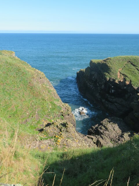
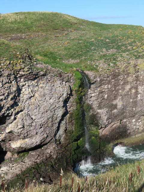
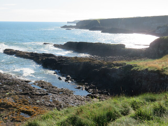
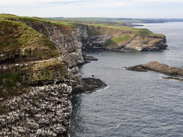
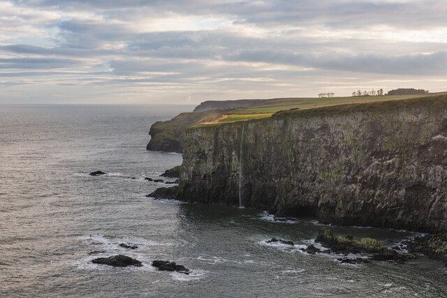
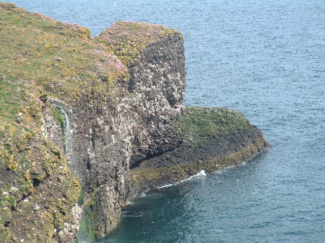
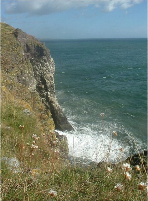
Dovethirl Coves is a scenic coastal area located in Kincardineshire, Scotland. Nestled along the North Sea, this beautiful landscape is characterized by its dramatic cliffs, sandy beaches, and picturesque coves. The coves are formed by the natural erosion of the cliffs, creating small sheltered areas along the coastline.

The area is known for its stunning sea views, with the crashing waves of the North Sea providing a mesmerizing backdrop. The rugged cliffs, reaching heights of up to 100 feet, offer a breath-taking sight for visitors. The coastal terrain is a mix of rocky outcrops and sandy stretches, making it perfect for both adventurous walkers and beach enthusiasts.

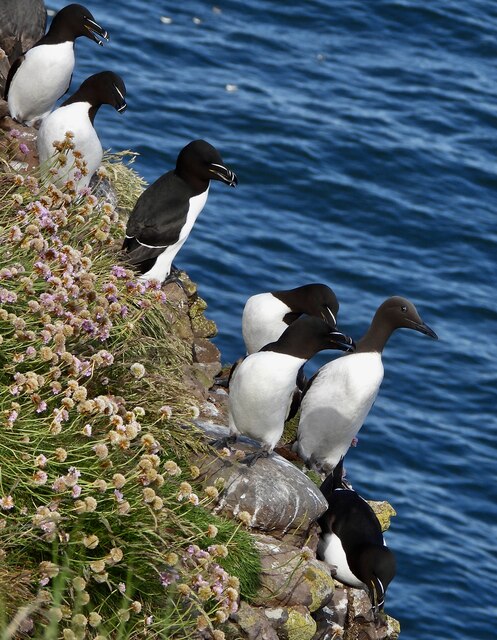
Dovethirl Coves is also home to a diverse range of wildlife. The coastal waters are teeming with marine life, including seals, dolphins, and a variety of seabirds. Birdwatchers can spot species such as gannets, puffins, and kittiwakes nesting on the cliff ledges.

The area is a popular spot for outdoor activities, such as hiking, rock climbing, and birdwatching. There are several walking trails that allow visitors to explore the rugged coastline and take in the panoramic views. The coves provide a tranquil escape, where visitors can relax and enjoy the sound of the waves crashing against the cliffs.

Overall, Dovethirl Coves is a captivating coastal destination that offers a unique blend of natural beauty, wildlife, and outdoor adventure. Whether you are seeking a peaceful retreat or an adrenaline-filled experience, this picturesque location has something to offer for everyone.

If you have any feedback on the listing, please let us know in the comments section below.

Dovethirl Coves Images

Images are sourced within 2km of 56.919065/-2.1998452 or Grid Reference NO8780. Thanks to Geograph Open Source API. All images are credited.

Looking down into Trollochy Trollochy is a short, cliff girt inlet below Crawton.
Looking down into Trollochy
Trollochy is a short, cliff girt inlet below Crawton.
Waterfall into the sea at Crawton A wee burn makes a dramatic plunge into the cliff bound inlet of Trollochy at Crawton.
Waterfall into the sea at Crawton
A wee burn makes a dramatic plunge into the cliff bound inlet of Trollochy at Crawton.
Rock ribs extending out into the sea at Crawton The view south from the small headland at Crawton where rocky reefs defy the waves. The view extends along Crawton Bay.
Rock ribs extending out into the sea at Crawton
The view south from the small headland at Crawton where rocky reefs defy the waves. The view extends along Crawton Bay.
Baler at work Tractor with baler working a harvested field near Cowieswells Farm.
Baler at work
Tractor with baler working a harvested field near Cowieswells Farm.
Razorbills and Guillemots Lives most of the year at sea, coming to land to breed. Both birds depends on the health of the marine environment. Fishing nets, pollution at sea and declining fish stocks all threaten these birds.
Razorbills and Guillemots
Lives most of the year at sea, coming to land to breed. Both birds depends on the health of the marine environment. Fishing nets, pollution at sea and declining fish stocks all threaten these birds.
Cliffs at Crawley Bird Sanctuary Not so many birds to be seen on the cliff face due to the devastation of Bird flu on the bird population.
Cliffs at Crawley Bird Sanctuary
Not so many birds to be seen on the cliff face due to the devastation of Bird flu on the bird population.
Waterfall in Tremuda Bay The water from small burn draining the fields above forms the small but prominent waterfall.
Waterfall in Tremuda Bay
The water from small burn draining the fields above forms the small but prominent waterfall.
A minor road near Catterline You can just see the foglights through the haar. There is a conifer shelter belt on the left, and the trees have thinned the fog enough to get a shot off.
A minor road near Catterline
You can just see the foglights through the haar. There is a conifer shelter belt on the left, and the trees have thinned the fog enough to get a shot off.
Farmland near Mill of Uras
Cotbank of Hilton
Cotbank of Hilton
New house, Cotbank of Hilton
National Cycle Route 1  Heading south near Cotbank of Hilton.
National Cycle Route 1
Heading south near Cotbank of Hilton.
National Cycle Route 1 Heading south.
National Cycle Route 1
Heading south.
Trollochy A fascinating name for this inlet in the cliffs near the fishing village of Crawton.
Trollochy
A fascinating name for this inlet in the cliffs near the fishing village of Crawton.
Crawton Ness
Crawton Ness
Catterline Burn Just off the A92 between Catterline and Stonehaven this is one of two
waterfalls in this beautiful wooded area.
Catterline Burn
Just off the A92 between Catterline and Stonehaven this is one of two waterfalls in this beautiful wooded area.
Kryenbye Cotbank of Hilton beyond. Seen from National Cycle Network route 1 which runs from the north of Shetland, generally keeping close to the east coast down to Dover. <span class="nowrap"><a title="http://www.sustrans.org.uk/default.asp?sID=1215164805562" rel="nofollow ugc noopener" href="http://www.sustrans.org.uk/default.asp?sID=1215164805562">Link</a><img style="margin-left:2px;" alt="External link" title="External link - shift click to open in new window" src="https://s1.geograph.org.uk/img/external.png" width="10" height="10"/></span>
Kryenbye
Cotbank of Hilton beyond. Seen from National Cycle Network route 1 which runs from the north of Shetland, generally keeping close to the east coast down to Dover. LinkExternal link
Fowlsheugh RSPB Reserve
Show me another place!

Dovethirl Coves is located at Grid Ref: NO8780 (Lat: 56.919065, Lng: -2.1998452)

Unitary Authority: Aberdeenshire

Police Authority: North East

What 3 Words

///baking.passively.shudders. Near Stonehaven, Aberdeenshire

Related Wikis

Craiglethy

Craiglethy (Scottish Gaelic: Creag Liathach - meaning grey rock) is a small island/skerry off Fowlsheugh on the east coast of Aberdeenshire, Scotland in...

Fowlsheugh

Fowlsheugh is a coastal nature reserve in Kincardineshire, northeast Scotland, known for its 70-metre-high (230 ft) cliff formations and habitat supporting...

Crawton

Crawton is a former fishing community on the southeast Aberdeenshire coast in Scotland, deserted since 1927. Approximately three miles (5 km) south of...

Thornyhive Bay

Thornyhive Bay is an embayment along the North Sea coast in Aberdeenshire, Scotland. This bay is situated approximately 2.5 miles south of the town of...

Nearby Amenities

Located within 500m of 56.919065,-2.1998452
Created By: almien_coastlines
Source: PGS
Lat/Long: 56.921602/-2.198185
Created By: almien_coastlines
Source: PGS
Lat/Long: 56.921733/-2.19865
Created By: almien_coastlines
Source: PGS
Lat/Long: 56.921863/-2.198882
Created By: almien_coastlines
Source: PGS
Lat/Long: 56.922376/-2.199105
Created By: almien_coastlines
Source: PGS
Lat/Long: 56.922379/-2.199573
Created By: almien_coastlines
Source: PGS
Lat/Long: 56.922635/-2.199567
Created By: almien_coastlines
Source: PGS
Lat/Long: 56.92276/-2.199096
Created By: almien_coastlines
Source: PGS
Lat/Long: 56.922885/-2.198626
Created By: almien_coastlines
Source: PGS
Lat/Long: 56.922372/-2.198403
Source: PGS
Lat/Long: 56.9165863/-2.1985334
Source: PGS
Lat/Long: 56.9168773/-2.198731
Source: PGS
Lat/Long: 56.9169993/-2.1988134
Source: PGS
Lat/Long: 56.9173195/-2.1988099
Source: PGS
Lat/Long: 56.9175592/-2.1989966
Source: PGS
Lat/Long: 56.9186519/-2.1998452
Source: PGS
Lat/Long: 56.9199427/-2.200158
Source: PGS
Lat/Long: 56.9209985/-2.2005072
Source: PGS
Lat/Long: 56.9213604/-2.2000472
Source: PGS
Lat/Long: 56.9225159/-2.2008765
Source: PGS
Lat/Long: 56.9227616/-2.2012829
Source: PGS
Lat/Long: 56.9231736/-2.1999257
Source: PGS
Lat/Long: 56.9149643/-2.1974162
Source: PGS
Lat/Long: 56.9155721/-2.1976839
Source: PGS
Lat/Long: 56.9160347/-2.1980586
Give Way
Direction: forward
Lat/Long: 56.9160425/-2.2046846
Uras Knaps
Place: locality
Lat/Long: 56.9192203/-2.2043937
Valehead
Place: isolated_dwelling
Lat/Long: 56.9158558/-2.2029614
Power: pole
Lat/Long: 56.9159504/-2.2035149
Power: pole
Lat/Long: 56.9157406/-2.2044712
Material: wood
Power: pole
Lat/Long: 56.9214931/-2.2067695
Material: wood
Power: pole
Lat/Long: 56.9208435/-2.2070707
Material: wood
Power: pole
Lat/Long: 56.920164/-2.2073846
Power: pole
Lat/Long: 56.9194672/-2.2077217
Power: pole
Lat/Long: 56.9190027/-2.2079239
The data included in this document is from www.openstreetmap.org. The data is made available under ODbL.

Have you been to Dovethirl Coves?

Leave your review of Dovethirl Coves below (or comments, questions and feedback).