Dooly Cove

Sea, Estuary, Creek in Kincardineshire

Scotland

Dooly Cove

Dunnottar Castle Dunnottar Castle, near Stonehaven, Aberdeenshire.
Dunnottar Castle Credit: Carroll Pierce

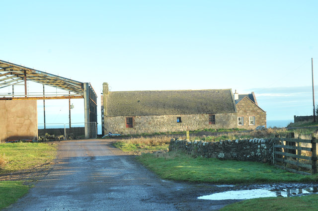
Dooly Cove is a picturesque coastal area located in Kincardineshire, Scotland. Nestled between the North Sea and the River Dee Estuary, it encompasses a stunning combination of rugged cliffs, sandy beaches, and a meandering creek, making it a truly unique and diverse natural landscape.

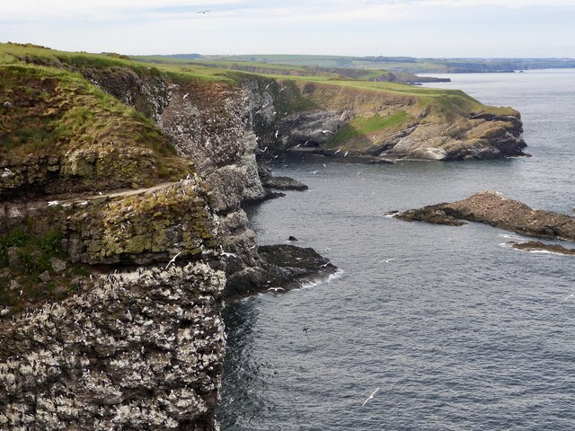
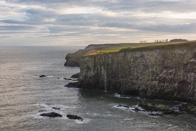
The Cove's coastline is characterized by its dramatic cliffs, which provide breathtaking views of the North Sea. The crashing waves against the rocks create a mesmerizing soundscape, while the salty sea breeze adds to the overall experience. The sandy beaches, particularly at low tide, offer an ideal spot for sunbathing and beachcombing.

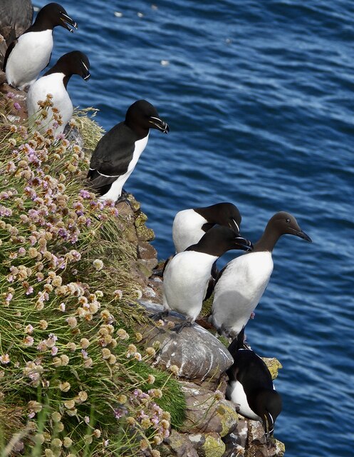
One of the main features of Dooly Cove is its estuary, where the River Dee meets the sea. This creates a dynamic ecosystem, attracting a rich variety of birdlife and marine species. The estuary is an important habitat for migratory birds, offering ample feeding opportunities during their annual journeys.

Dooly Cove is also home to a charming creek that winds its way through the landscape. The creek, fed by freshwater from surrounding hills, meanders through lush vegetation, creating a tranquil and idyllic scene. It serves as an important water source for local wildlife and adds to the overall beauty and diversity of the area.

Visitors to Dooly Cove can enjoy various activities such as hiking along the cliff paths, exploring the sandy beaches, birdwatching, and even kayaking or canoeing in the creek. The area is also a popular spot for photographers and nature enthusiasts, who are drawn to its breathtaking vistas and abundant wildlife.

Overall, Dooly Cove in Kincardineshire offers a captivating blend of sea, estuary, and creek, providing visitors with a unique and immersive natural experience.

If you have any feedback on the listing, please let us know in the comments section below.

Dooly Cove Images

Images are sourced within 2km of 56.932208/-2.1998006 or Grid Reference NO8782. Thanks to Geograph Open Source API. All images are credited.

Dunnottar Castle Dunnottar Castle, near Stonehaven, Aberdeenshire.
Dunnottar Castle
Dunnottar Castle, near Stonehaven, Aberdeenshire.
Razorbills and Guillemots Lives most of the year at sea, coming to land to breed. Both birds depends on the health of the marine environment. Fishing nets, pollution at sea and declining fish stocks all threaten these birds.
Razorbills and Guillemots
Lives most of the year at sea, coming to land to breed. Both birds depends on the health of the marine environment. Fishing nets, pollution at sea and declining fish stocks all threaten these birds.
Cliffs at Crawley Bird Sanctuary Not so many birds to be seen on the cliff face due to the devastation of Bird flu on the bird population.
Cliffs at Crawley Bird Sanctuary
Not so many birds to be seen on the cliff face due to the devastation of Bird flu on the bird population.
Waterfall in Tremuda Bay The water from small burn draining the fields above forms the small but prominent waterfall.
Waterfall in Tremuda Bay
The water from small burn draining the fields above forms the small but prominent waterfall.
Looking at Dunnottar Castle Yet another view caught in very strange light as a haar (sea fog) thickens.  The castle, which sits on an impregnable outcrop of conglomerate rock, is a scheduled monument and was designated as such as early as 1920: SM986 <span class="nowrap"><a title="http://portal.historicenvironment.scot/designation/SM986" rel="nofollow ugc noopener" href="http://portal.historicenvironment.scot/designation/SM986">Link</a><img style="margin-left:2px;" alt="External link" title="External link - shift click to open in new window" src="https://s1.geograph.org.uk/img/external.png" width="10" height="10"/></span> .
Looking at Dunnottar Castle
Yet another view caught in very strange light as a haar (sea fog) thickens. The castle, which sits on an impregnable outcrop of conglomerate rock, is a scheduled monument and was designated as such as early as 1920: SM986 LinkExternal link .
Dunnottar Lodge Typical sandstone construction: the sign below the window says 'purchase tickets at the castle'.
Dunnottar Lodge
Typical sandstone construction: the sign below the window says 'purchase tickets at the castle'.
Outbuildings at Mains of Dunnottar
Conglomerate rocks at Castle Haven Part of the Dunnottar Castle conglomerate formation (conglomerate and sandstone, interbedded): sedimentary bedrock formed between 443.8 and 393.3 million years ago during the Silurian and Devonian periods.
Conglomerate rocks at Castle Haven
Part of the Dunnottar Castle conglomerate formation (conglomerate and sandstone, interbedded): sedimentary bedrock formed between 443.8 and 393.3 million years ago during the Silurian and Devonian periods.
Walking the beach at Castle Haven Bay The cliffs are made up of conglomerate rock (<span class="nowrap"><a title="https://en.wikipedia.org/wiki/Conglomerate_(geology)" rel="nofollow ugc noopener" href="https://en.wikipedia.org/wiki/Conglomerate_(geology)">Link</a><img style="margin-left:2px;" alt="External link" title="External link - shift click to open in new window" src="https://s1.geograph.org.uk/img/external.png" width="10" height="10"/></span> ), which consist of rounded clasts of rock embedded in a matrix of hardened sediment.
Walking the beach at Castle Haven Bay
The cliffs are made up of conglomerate rock (LinkExternal link ), which consist of rounded clasts of rock embedded in a matrix of hardened sediment.
Looking down the gorge towards the castle
Water Tank There is a door at the back of this roof shape that appears to have no sides.  It was too dark but I think all this structure contains is water.
Water Tank
There is a door at the back of this roof shape that appears to have no sides. It was too dark but I think all this structure contains is water.
Minor road, Gallaton
Stripwood, Halymyres The wood is used by the nearby stables as a riding route. There are often useful paths in strip woods.
Stripwood, Halymyres
The wood is used by the nearby stables as a riding route. There are often useful paths in strip woods.
Mains of Dunnottar The road is quiet now as beyond the castle parking it is closed to motorised vehicles due to subsidence. It used to be the A92.
Mains of Dunnottar
The road is quiet now as beyond the castle parking it is closed to motorised vehicles due to subsidence. It used to be the A92.
Dunnottar Castle Dunnottar Castle, situated on the most spectacular rocks is most famous for keeping Cromwell's army at bay during his occupation of Scotland in the 1650s. It was vitally important to stand firm since Scotland's Honours (the crown jewels) were hidden in the castle for safe keeping. Had Cromwell captured the honours, they would have been destroyed or taken to London forever, in the same way the Stone of Scone was stolen never to return though it is now back in Edinburgh 'on loan' There was nothing the English would not do in their attempts to subdue the Scottish nation.
Dunnottar Castle
Dunnottar Castle, situated on the most spectacular rocks is most famous for keeping Cromwell's army at bay during his occupation of Scotland in the 1650s. It was vitally important to stand firm since Scotland's Honours (the crown jewels) were hidden in the castle for safe keeping. Had Cromwell captured the honours, they would have been destroyed or taken to London forever, in the same way the Stone of Scone was stolen never to return though it is now back in Edinburgh 'on loan' There was nothing the English would not do in their attempts to subdue the Scottish nation.
Buildings at Mains of Dunnottar Farm In Aberdeenshire.
Buildings at Mains of Dunnottar Farm
In Aberdeenshire.
Gallaton Farm
Gallaton Farm
A92 at Uras
A92 at Uras
Show me another place!

Dooly Cove is located at Grid Ref: NO8782 (Lat: 56.932208, Lng: -2.1998006)

Unitary Authority: Aberdeenshire

Police Authority: North East

What 3 Words

///animator.pitching.meanings. Near Stonehaven, Aberdeenshire

Related Wikis

Thornyhive Bay

Thornyhive Bay is an embayment along the North Sea coast in Aberdeenshire, Scotland. This bay is situated approximately 2.5 miles south of the town of...

Craiglethy

Craiglethy (Scottish Gaelic: Creag Liathach - meaning grey rock) is a small island/skerry off Fowlsheugh on the east coast of Aberdeenshire, Scotland in...

Dunnottar Castle

Dunnottar Castle (Scottish Gaelic: Dùn Fhoithear, "fort on the shelving slope") is a ruined medieval fortress located upon a rocky headland on the north...

Bowdun Head

Bowdun Head is a headland landform on the North Sea coast approximately one kilometre south of Stonehaven, Scotland.(Ordnance Survey, 2004) Slightly to...

Nearby Amenities

Located within 500m of 56.932208,-2.1998006
Created By: almien_coastlines
Source: PGS
Lat/Long: 56.927874/-2.19805
Source: PGS
Lat/Long: 56.9279653/-2.1986213
Source: PGS
Lat/Long: 56.9295212/-2.1979486
Source: PGS
Lat/Long: 56.9296842/-2.1979406
Created By: almien_coastlines
Source: PGS
Lat/Long: 56.929793/-2.197776
Source: PGS
Lat/Long: 56.9306096/-2.1971944
Source: PGS
Lat/Long: 56.9309065/-2.1971573
Source: PGS
Lat/Long: 56.9313378/-2.1972416
Source: PGS
Lat/Long: 56.9317/-2.1977775
Source: PGS
Lat/Long: 56.9319491/-2.1990247
Source: PGS
Lat/Long: 56.9322229/-2.1997717
Created By: almien_coastlines
Source: PGS
Lat/Long: 56.932241/-2.200298
Source: PGS
Lat/Long: 56.9324648/-2.2003124
Source: PGS
Lat/Long: 56.9327875/-2.2008414
Source: PGS
Lat/Long: 56.9329447/-2.2008094
Source: PGS
Lat/Long: 56.9330401/-2.2004313
Source: PGS
Lat/Long: 56.9332658/-2.2002121
Source: PGS
Lat/Long: 56.9332434/-2.1997907
Source: PGS
Lat/Long: 56.9334835/-2.2001016
Source: PGS
Lat/Long: 56.9335385/-2.199526
Source: PGS
Lat/Long: 56.934033/-2.1989807
Source: PGS
Lat/Long: 56.9341533/-2.1986315
Source: PGS
Lat/Long: 56.9339965/-2.1981023
Source: PGS
Lat/Long: 56.9359015/-2.1988238
Source: PGS
Lat/Long: 56.9363605/-2.1991159
Source: PGS
Lat/Long: 56.9366364/-2.1987731
Generator Method: photovoltaic
Generator Output Electricity: yes
Generator Source: solar
Generator Type: solar_photovoltaic_panel
Power: generator
Lat/Long: 56.9346373/-2.2059312
Material: wood
Power: pole
Lat/Long: 56.9294312/-2.2062608
Material: wood
Power: pole
Lat/Long: 56.9300094/-2.2061934
Material: wood
Power: pole
Lat/Long: 56.9305945/-2.2061154
Material: wood
Power: pole
Lat/Long: 56.9311899/-2.206029
Material: wood
Power: pole
Lat/Long: 56.9316715/-2.2059743
Material: wood
Power: pole
Lat/Long: 56.9323623/-2.2058837
Power: pole
Lat/Long: 56.9315451/-2.2067516
Power: pole
Lat/Long: 56.9314187/-2.2075605
Material: wood
Power: pole
Lat/Long: 56.9329612/-2.2058036
Material: wood
Power: pole
Lat/Long: 56.933568/-2.2057152
Material: wood
Power: pole
Lat/Long: 56.9341611/-2.2056435
The data included in this document is from www.openstreetmap.org. The data is made available under ODbL.

Have you been to Dooly Cove?

Leave your review of Dooly Cove below (or comments, questions and feedback).