Bar Creek

Sea, Estuary, Creek in Cornwall

England

Bar Creek

Farmland, St Michael Penkevil A view across the valley of the Tresillian River to fields at St Clement.
Farmland, St Michael Penkevil Credit: Andrew Smith

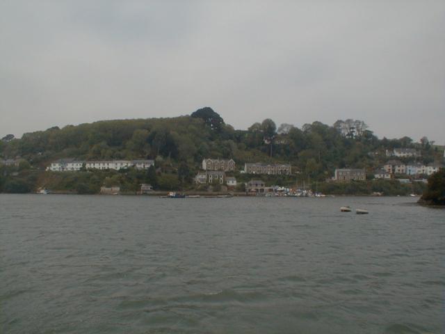
Bar Creek is a picturesque water body located in Cornwall, a county in the southwestern part of England. It is nestled between the charming villages of St. Mawes and Falmouth, offering locals and visitors a tranquil natural oasis. This estuary, also known as a creek, is formed where the river meets the sea, creating a unique and diverse ecosystem.

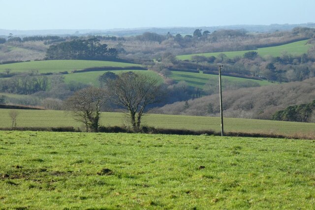
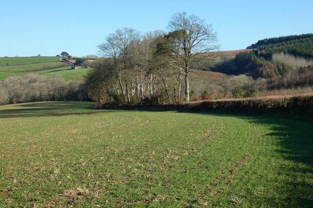
The creek is characterized by its breathtaking scenery, with lush green hills surrounding the clear blue waters. It is a haven for wildlife enthusiasts and birdwatchers, as the area is home to a wide variety of bird species, including herons, kingfishers, and egrets. The creek's tidal nature also attracts seals and occasionally dolphins, providing a fascinating sight for nature lovers.

The creek is an ideal spot for water activities such as kayaking, paddleboarding, and sailing. Its calm waters and gentle currents make it suitable for beginners, while more experienced water sports enthusiasts can explore the creek's numerous hidden coves and secret beaches. Fishing is also popular in Bar Creek, with anglers seeking to catch a variety of fish species, including mullet and bass.

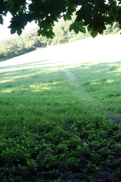
The surrounding area offers ample opportunities for exploration and relaxation. Picturesque walking trails wind through the nearby countryside, allowing visitors to enjoy the stunning views and observe the local flora and fauna. Additionally, there are several quaint pubs and restaurants in the vicinity, providing a perfect setting to unwind after a day spent by the creek.

Bar Creek, Cornwall, is a true gem of natural beauty, offering visitors a peaceful and idyllic escape from the hustle and bustle of everyday life. Whether seeking adventure on the water or simply desiring a serene environment to soak in the tranquility, this enchanting creek has something to offer for everyone.

If you have any feedback on the listing, please let us know in the comments section below.

Bar Creek Images

Images are sourced within 2km of 50.248454/-5.020643 or Grid Reference SW8443. Thanks to Geograph Open Source API. All images are credited.

Farmland, St Michael Penkevil A view across the valley of the Tresillian River to fields at St Clement.
Farmland, St Michael Penkevil
A view across the valley of the Tresillian River to fields at St Clement.
Farmland, St Michael Penkevil Arable land beside the road descending towards Lamorran. A building at Trewonnal can be seen in the background.
Farmland, St Michael Penkevil
Arable land beside the road descending towards Lamorran. A building at Trewonnal can be seen in the background.
Tresillian River, St Clement With the tide out, a view across mud to woodland beside Merther Pond.
Tresillian River, St Clement
With the tide out, a view across mud to woodland beside Merther Pond.
Pasture, St Clement Beside the direct footpath between the village and Malpas.
Pasture, St Clement
Beside the direct footpath between the village and Malpas.
Benchmark Left middle of photo
Benchmark
Left middle of photo
Old Kea Church Tower
Menadews Farm, St Clement Viewed from the lane above the village.
Menadews Farm, St Clement
Viewed from the lane above the village.
Tresemple Pond, St Clement A causeway separates the pond from the Tresillian River estuary.
Tresemple Pond, St Clement
A causeway separates the pond from the Tresillian River estuary.
Meadow to the North of Trennick Lane This Meadow path is the scene of the annual Truro Running Club, Meet Your Max, club run. A lovely canter around the area to the North of the Estuary near Malpas.
Meadow to the North of Trennick Lane
This Meadow path is the scene of the annual Truro Running Club, Meet Your Max, club run. A lovely canter around the area to the North of the Estuary near Malpas.
Tregothnan See <a href="https://www.geograph.org.uk/photo/2671594">SW8541 : Tregothnan</a>.  Viewed from Trelissick Gardens across the River Fal, with laid up shipping in the foreground (see <a href="https://www.geograph.org.uk/photo/2671550">SW8439 : Shipping on the River Fal</a>).
Tregothnan
See SW8541 : Tregothnan. Viewed from Trelissick Gardens across the River Fal, with laid up shipping in the foreground (see SW8439 : Shipping on the River Fal).
Tregothnan The family seat of the Boscowans, Viscount Falmouth.  The house originally dates from 1652, but was rebuilt in the 1820a to a design of William Wilkins, architect also of the National Gallery and buildings at both King's College and Downing College, Cambridge.  Seen here from Trelissick, across the River Fal.  Grade I listed - for listing particulars, see <span class="nowrap"><a title="www.historicengland.org.uk/listing/the-list/list-entry/1141069" rel="nofollow ugc noopener" href="http://www.historicengland.org.uk/listing/the-list/list-entry/1141069">Link</a><img style="margin-left:2px;" alt="External link" title="External link - shift click to open in new window" src="https://s1.geograph.org.uk/img/external.png" width="10" height="10"/></span>.
Tregothnan
The family seat of the Boscowans, Viscount Falmouth. The house originally dates from 1652, but was rebuilt in the 1820a to a design of William Wilkins, architect also of the National Gallery and buildings at both King's College and Downing College, Cambridge. Seen here from Trelissick, across the River Fal. Grade I listed - for listing particulars, see LinkExternal link.
Mouth of Tresillian River
Riverside house at Malpas
St Clement's church, St Clement
Looking upriver to Truro
The road into St Clement At this point, the road drops steeply into the village.  It is marked as a steep hill on OS maps
The road into St Clement
At this point, the road drops steeply into the village. It is marked as a steep hill on OS maps
Village notice board for St Clement A hedge and notice board on the road as it enters the village; plenty of ivy on the trees!
Village notice board for St Clement
A hedge and notice board on the road as it enters the village; plenty of ivy on the trees!
Show me another place!

Bar Creek is located at Grid Ref: SW8443 (Lat: 50.248454, Lng: -5.020643)

Unitary Authority: Cornwall

Police Authority: Devon and Cornwall

What 3 Words

///mouths.revived.sadly. Near Truro, Cornwall

Related Wikis

Malpas, Cornwall

Malpas is a riverside village, and former port, in Cornwall, England, United Kingdom. It is situated two miles (3 km) southeast of the city of Truro, on...

St Clement, Cornwall

St Clement (Cornish: Klemens) is a civil parish and village in Cornwall, England, United Kingdom. It is situated southeast of Truro in the valley of the...

Diocese of Truro

The Diocese of Truro (established 1876) is a Church of England diocese in the Province of Canterbury which covers Cornwall, the Isles of Scilly and a small...

Merther Lane

Merther Lane is a hamlet in the parish of St Michael Penkevil, Cornwall, England. == References ==

Nearby Amenities

Located within 500m of 50.248454,-5.020643
Source: PGS
Lat/Long: 50.2454967/-5.023821
Source: PGS
Lat/Long: 50.246112/-5.0233649
Source: PGS
Lat/Long: 50.246904/-5.0225182
Source: PGS
Lat/Long: 50.2470816/-5.0222484
Source: PGS
Lat/Long: 50.2472558/-5.022093
Source: PGS
Lat/Long: 50.2474588/-5.0218047
Source: PGS
Lat/Long: 50.2479171/-5.0209389
Source: PGS
Lat/Long: 50.2481278/-5.0202295
Source: PGS
Lat/Long: 50.24844/-5.0192531
Source: PGS
Lat/Long: 50.2486541/-5.0188737
Source: PGS
Lat/Long: 50.2491501/-5.0180166
Created By: almien_coastlines
Source: PGS
Lat/Long: 50.24921/-5.017718
Source: PGS
Lat/Long: 50.2495566/-5.0170966
Source: PGS
Lat/Long: 50.2498241/-5.0166782
Source: PGS
Lat/Long: 50.2500882/-5.0163617
Source: PGS
Lat/Long: 50.250397/-5.0157234
Source: PGS
Lat/Long: 50.2503455/-5.014747
Source: PGS
Lat/Long: 50.248119/-5.014074
Source: PGS
Lat/Long: 50.247572/-5.01605
Created By: almien_coastlines
Source: PGS
Lat/Long: 50.247309/-5.016438
Created By: almien_coastlines
Source: PGS
Lat/Long: 50.247025/-5.018026
Created By: almien_coastlines
Source: PGS
Lat/Long: 50.246762/-5.018414
Created By: almien_coastlines
Source: PGS
Lat/Long: 50.246485/-5.019602
Created By: almien_coastlines
Source: PGS
Lat/Long: 50.246215/-5.02039
Created By: almien_coastlines
Source: PGS
Lat/Long: 50.245952/-5.020779
Created By: almien_coastlines
Source: PGS
Lat/Long: 50.245817/-5.021173
Source: PGS
Lat/Long: 50.2448115/-5.0208327
Source: PGS
Lat/Long: 50.2447362/-5.0204878
Source: PGS
Lat/Long: 50.2446683/-5.0172903
Malpas
Is In County: Cornwall
Name Kw: Gwanndremen
Place: hamlet
Wikidata: Q6744583
Lat/Long: 50.2458288/-5.0241227
The data included in this document is from www.openstreetmap.org. The data is made available under ODbL.

Have you been to Bar Creek?

Leave your review of Bar Creek below (or comments, questions and feedback).