Battlesden

Settlement in Bedfordshire

England

Battlesden

B5704 London Road towards Woburn
B5704 London Road towards Woburn Credit: Robin Webster

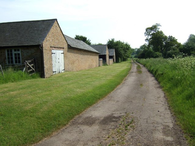
Battlesden is a small village located in the county of Bedfordshire, England. Situated approximately 5 miles southeast of the town of Woburn, it is surrounded by picturesque countryside and rolling hills. With a population of around 100 residents, Battlesden exudes a tranquil and rural charm.

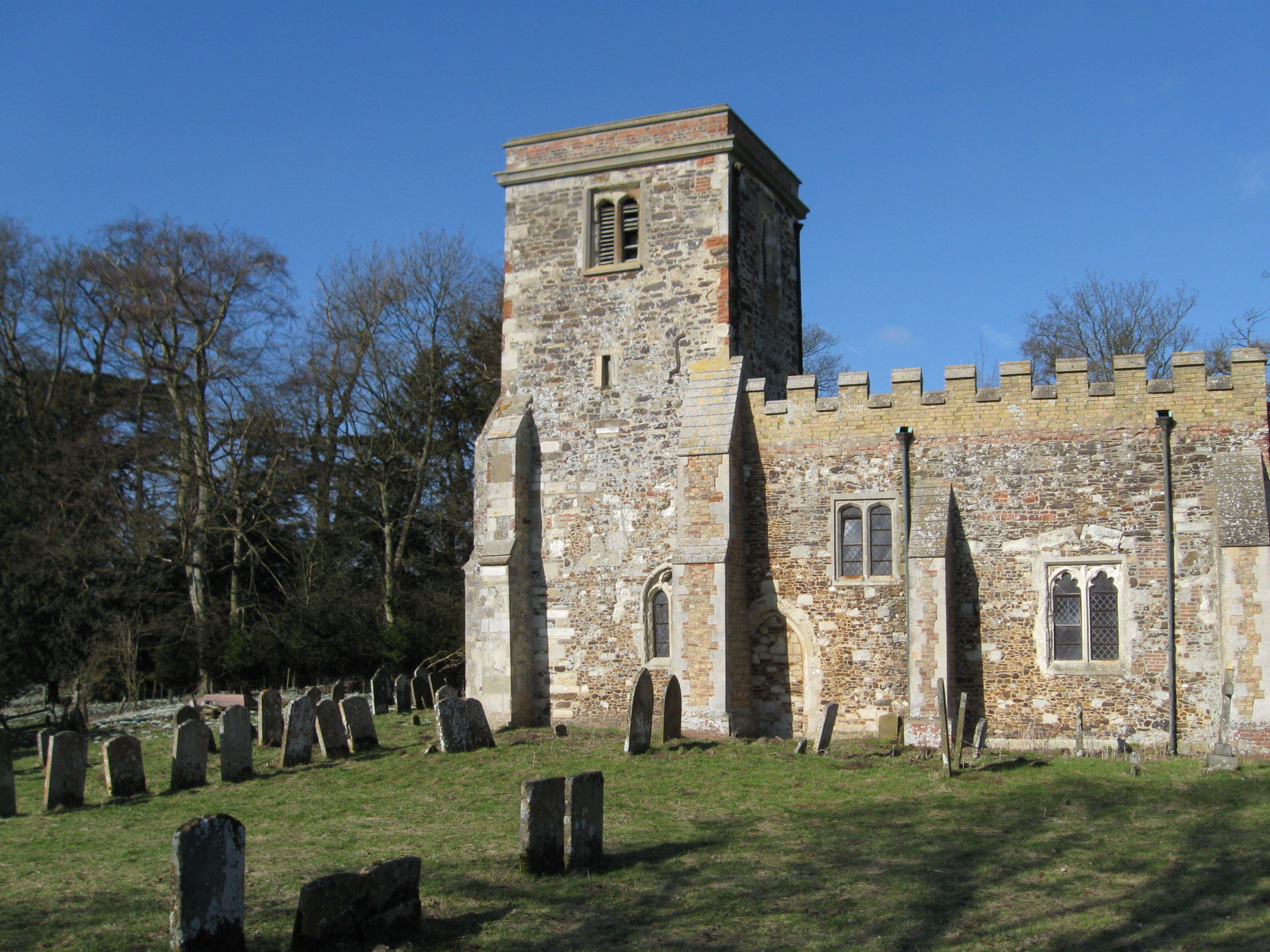
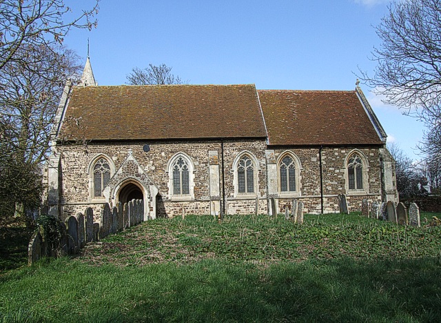
The village is known for its historic architecture, with many of the buildings dating back to the 17th and 18th centuries. The centerpiece of Battlesden is St. Peter and All Saints Church, an enchanting Grade II listed building constructed in the 14th century. Its timeless beauty and stunning stained glass windows make it a popular attraction for visitors.

The village boasts a close-knit community, with various events and activities organized throughout the year. The annual village fete is a highlight, bringing together residents and visitors for a day of traditional games, food, and entertainment. Battlesden also has a village hall, which serves as a hub for local gatherings and social events.

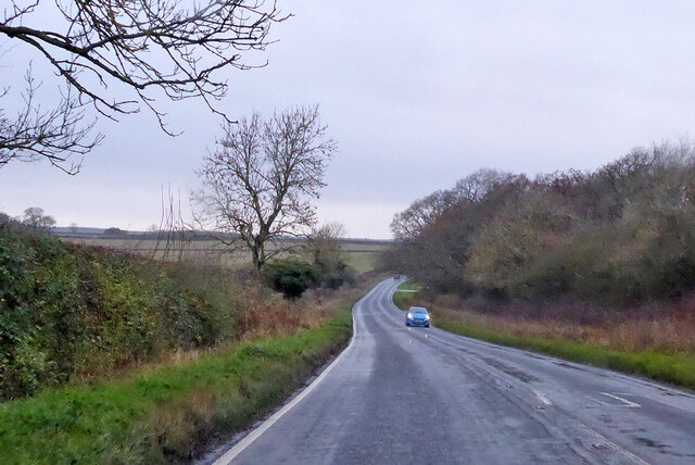
Surrounded by lush green fields and woodlands, Battlesden offers ample opportunities for outdoor activities such as walking, hiking, and cycling. The nearby Woburn Abbey Deer Park and the Greensand Ridge are popular destinations for nature enthusiasts.

While the village itself is quiet and peaceful, it benefits from its close proximity to larger towns and cities. The bustling town of Bedford is just a short drive away, providing residents with access to a wide range of amenities, including shopping centers, restaurants, and healthcare facilities.

In summary, Battlesden is a picturesque and idyllic village in Bedfordshire, offering a tight-knit community, historic architecture, and access to beautiful natural surroundings. It is a haven for those seeking a peaceful and rural lifestyle.

If you have any feedback on the listing, please let us know in the comments section below.

Battlesden Images

Images are sourced within 2km of 51.950114/-0.600843 or Grid Reference SP9628. Thanks to Geograph Open Source API. All images are credited.

B5704 London Road towards Woburn
Farmland, Potsgrove A bridleway through oats climbs towards the B5704.
Farmland, Potsgrove
A bridleway through oats climbs towards the B5704.
Ford Spinney Taken from the A4012 near Battlesden
Ford Spinney
Taken from the A4012 near Battlesden
Hill Farm Sheep These sheep belong to Hill Farm which can be seen in the background. The lane abruptly ends just after this point with a private road continuing to the farm and a track leading to Battlesden.
Hill Farm Sheep
These sheep belong to Hill Farm which can be seen in the background. The lane abruptly ends just after this point with a private road continuing to the farm and a track leading to Battlesden.
Lane to Hill Farm, Battlesden This lane leads off the Hockliffe Road near Watergate Lodge and goes to Hill Farm (see <a href="https://www.geograph.org.uk/photo/171948">SP9728 : Hill Farm Sheep</a>). As a track it continues to Battlesden.
Lane to Hill Farm, Battlesden
This lane leads off the Hockliffe Road near Watergate Lodge and goes to Hill Farm (see SP9728 : Hill Farm Sheep). As a track it continues to Battlesden.
Hockliffe Grange Peeping over the trees which surround it, this is about the best view you can get of Hockliffe Grange, taken from the lane that approaches it from the church.
Hockliffe Grange
Peeping over the trees which surround it, this is about the best view you can get of Hockliffe Grange, taken from the lane that approaches it from the church.
Gates to Hockliffe Rectory Rather wonderfully overgrown gates and fencing to The Rectory, Church End, Hockliffe. This is almost opposite the church but in the adjacent square.
Gates to Hockliffe Rectory
Rather wonderfully overgrown gates and fencing to The Rectory, Church End, Hockliffe. This is almost opposite the church but in the adjacent square.
Ground Farm, Hockliffe The road from the church out to this farm gradually deteriorates until it becomes a muddy track with grass in the middle. It then improves a little just before you reach this farm. The area the farm is in is called "Hockliffe Grounds" hence the name of the farm.
Ground Farm, Hockliffe
The road from the church out to this farm gradually deteriorates until it becomes a muddy track with grass in the middle. It then improves a little just before you reach this farm. The area the farm is in is called "Hockliffe Grounds" hence the name of the farm.
Fields near Battlesden Looking across fields to the church and manor at Battlesden (which are in the adjacent square, see <a href="https://www.geograph.org.uk/photo/183068">SP9529 : St Peter and All Saints, Battlesden</a>). I think the crop is wheat, but as it has not yet produced its ears I'm by no means certain.
Fields near Battlesden
Looking across fields to the church and manor at Battlesden (which are in the adjacent square, see SP9529 : St Peter and All Saints, Battlesden). I think the crop is wheat, but as it has not yet produced its ears I'm by no means certain.
Lane to Battlesden This is the lane to Battlesden having left the main A4012 and travelled a few hundred yards. There is a footpath off to the right (North) at this point which leads towards Milton Bryan.
Lane to Battlesden
This is the lane to Battlesden having left the main A4012 and travelled a few hundred yards. There is a footpath off to the right (North) at this point which leads towards Milton Bryan.
Approaching Battlesden Church This lane runs up to the church at Battlesden (see <a href="https://www.geograph.org.uk/photo/183068">SP9529 : St Peter and All Saints, Battlesden</a>) then comes to an abrupt halt as a road but continues as a footpath past the church and Battlesden House. The precariously leaning tree on the right looks like a Scots Pine to me. The manor here was once owned by the remarkably-named Sir Gregory Page-Turner who should have been a novelist really !
Approaching Battlesden Church
This lane runs up to the church at Battlesden (see SP9529 : St Peter and All Saints, Battlesden) then comes to an abrupt halt as a road but continues as a footpath past the church and Battlesden House. The precariously leaning tree on the right looks like a Scots Pine to me. The manor here was once owned by the remarkably-named Sir Gregory Page-Turner who should have been a novelist really !
Centre Farm, Battlesden These buildings belong to Centre Farm in Battlesden. The track continues to Hill Farm (see <a href="https://www.geograph.org.uk/photo/171948">SP9728 : Hill Farm Sheep</a>) and according to my old 1:50000 is marked as a yellow (drivable) lane - but having seen the other end of it I think it would be a little cruel to an ordinary saloon car !
Centre Farm, Battlesden
These buildings belong to Centre Farm in Battlesden. The track continues to Hill Farm (see SP9728 : Hill Farm Sheep) and according to my old 1:50000 is marked as a yellow (drivable) lane - but having seen the other end of it I think it would be a little cruel to an ordinary saloon car !
Battlesden Taken at the hairpin (see map) in Battlesden where the main drivable lane doubles back to get to Battlesden church. In addition to this lane and the track next to <a href="https://www.geograph.org.uk/photo/183064">SP9628 : Centre Farm, Battlesden</a> there is a more direct footpath here to Hill Farm and a bridleway which heads towards Hockliffe. There are very few properties in this parish which is a very quiet little oasis. It has a church which I think means that it is a village, but there are many hamlets bigger than this !
Battlesden
Taken at the hairpin (see map) in Battlesden where the main drivable lane doubles back to get to Battlesden church. In addition to this lane and the track next to SP9628 : Centre Farm, Battlesden there is a more direct footpath here to Hill Farm and a bridleway which heads towards Hockliffe. There are very few properties in this parish which is a very quiet little oasis. It has a church which I think means that it is a village, but there are many hamlets bigger than this !
St Peter and All Saints, Battlesden Tiny Battlesden's rather splendid church. Although not particularly large I would think that this church could hold the entire population of Battlesden five times over ! Read more about Battlesden and its church here <span class="nowrap"><a title="http://www.british-history.ac.uk/report.asp?compid=42445" rel="nofollow ugc noopener" href="http://www.british-history.ac.uk/report.asp?compid=42445">Link</a><img style="margin-left:2px;" alt="External link" title="External link - shift click to open in new window" src="https://s1.geograph.org.uk/img/external.png" width="10" height="10"/></span>
St Peter and All Saints, Battlesden
Tiny Battlesden's rather splendid church. Although not particularly large I would think that this church could hold the entire population of Battlesden five times over ! Read more about Battlesden and its church here LinkExternal link
House and churchyard, Battlesden The western part of the churchyard at Battlesden is very overgrown with tall grass and cow parsley in abundance. I would guess that the house here - one of very few in Battlesden - was the rectory. As most of the properties here were built on the instructions of the Duke of Bedford, I would think that this one certainly was.
House and churchyard, Battlesden
The western part of the churchyard at Battlesden is very overgrown with tall grass and cow parsley in abundance. I would guess that the house here - one of very few in Battlesden - was the rectory. As most of the properties here were built on the instructions of the Duke of Bedford, I would think that this one certainly was.
Milton Lodge Most of the lodgehouses around here are to the enormous Woburn Abbey estate, but this one near Milton Bryan is an exception. This lodge marks the start of Battlesden Avenue which leads (after about a mile) to Battlesden House next to Battlesden Church. There is some information about this manor house here <span class="nowrap"><a title="http://www.british-history.ac.uk/report.asp?compid=42445" rel="nofollow ugc noopener" href="http://www.british-history.ac.uk/report.asp?compid=42445">Link</a><img style="margin-left:2px;" alt="External link" title="External link - shift click to open in new window" src="https://s1.geograph.org.uk/img/external.png" width="10" height="10"/></span>
Milton Lodge
Most of the lodgehouses around here are to the enormous Woburn Abbey estate, but this one near Milton Bryan is an exception. This lodge marks the start of Battlesden Avenue which leads (after about a mile) to Battlesden House next to Battlesden Church. There is some information about this manor house here LinkExternal link
Milton Lodge near Milton Bryan A closer view of the lodge in <a href="https://www.geograph.org.uk/photo/183076">SP9630 : Milton Lodge</a>
Most of the lodgehouses around here are to the enormous Woburn Abbey estate, but this one near Milton Bryan is an exception. This lodge marks the start of Battlesden Avenue which leads (after about a mile) to Battlesden House next to Battlesden Church. There is some information about this manor house here <span class="nowrap"><a title="http://www.british-history.ac.uk/report.asp?compid=42445" rel="nofollow ugc noopener" href="http://www.british-history.ac.uk/report.asp?compid=42445">Link</a><img style="margin-left:2px;" alt="External link" title="External link - shift click to open in new window" src="https://s1.geograph.org.uk/img/external.png" width="10" height="10"/></span>
Milton Lodge near Milton Bryan
A closer view of the lodge in SP9630 : Milton Lodge Most of the lodgehouses around here are to the enormous Woburn Abbey estate, but this one near Milton Bryan is an exception. This lodge marks the start of Battlesden Avenue which leads (after about a mile) to Battlesden House next to Battlesden Church. There is some information about this manor house here LinkExternal link
Hockliffe Grounds Looking back down the track to Grounds Farm, Hockliffe. Just beyond this bend was a quite deep, very muddy puddle straddling the whole track.
Hockliffe Grounds
Looking back down the track to Grounds Farm, Hockliffe. Just beyond this bend was a quite deep, very muddy puddle straddling the whole track.
Show me another place!

Battlesden is located at Grid Ref: SP9628 (Lat: 51.950114, Lng: -0.600843)

Unitary Authority: Central Bedfordshire

Police Authority: Bedfordshire

What 3 Words

///differ.outbursts.usage. Near Battlesden, Bedfordshire

Nearby Locations

Battlesden Battlesden

Related Wikis

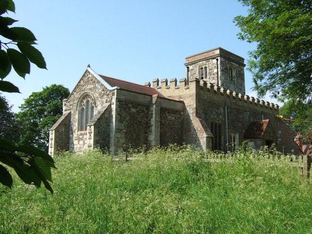
Church of St Peter & All Saints, Battlesden

Church of St Peter & All Saints is a Grade I listed church in Battlesden, Bedfordshire, England. It became a listed building on 23 January 1961. ��2...

Battlesden

Battlesden is a hamlet and civil parish in the Central Bedfordshire district of Bedfordshire, England. It is just north of the A5, between Dunstable...

Potsgrove

Potsgrove is a small village and civil parish located in the Central Bedfordshire district of Bedfordshire, England. The parish includes the hamlet of...

St Mary's Church, Potsgrove

St Mary's Church is a redundant Anglican church in the village of Potsgrove, Bedfordshire. England. It is recorded in the National Heritage List for England...

Nearby Amenities

Located within 500m of 51.950114,-0.600843
Battlesden
Place: hamlet
Source: survey
Lat/Long: 51.9479314/-0.594986
Post Box
Collection Times: Mo-Fr 16:00; Sa 08:15
Operator: Royal Mail
Post Box Type: wall
Ref: MK17 25
Royal Cypher: VR
Royal Cypher Wikidata: Q33102356
Source: survey
Lat/Long: 51.9491289/-0.5970741
The data included in this document is from www.openstreetmap.org. The data is made available under ODbL.

Have you been to Battlesden?

Leave your review of Battlesden below (or comments, questions and feedback).