Battlefield

Settlement in Shropshire

England

Battlefield

Sunderton Farm View
Sunderton Farm View Credit: Gordon Griffiths

Battlefield is a small village located in the county of Shropshire, England. Situated approximately 3 miles north of the town center of Shrewsbury, it falls within the civil parish of Pimhill. The village is located near the A53 road, providing convenient access to the surrounding areas.

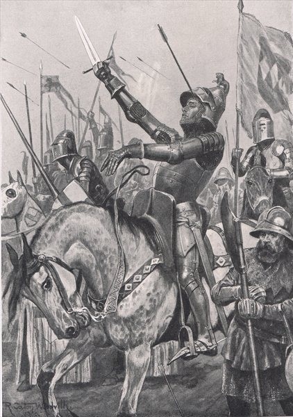
The name "Battlefield" is derived from its historical significance, as it was the site of the Battle of Shrewsbury in 1403. This battle was a significant conflict during the reign of King Henry IV, where his forces fought against a rebellion led by Henry "Harry Hotspur" Percy. Today, visitors can explore the Battlefield Heritage Park, which commemorates this historic event and offers a fascinating insight into medieval warfare.

In terms of amenities, Battlefield is a primarily residential area, offering a peaceful and picturesque setting with a mix of traditional and modern houses. The village benefits from the nearby amenities of Shrewsbury, including a wide range of shops, restaurants, and leisure facilities. It also provides easy access to the beautiful Shropshire countryside, with its rolling hills, charming villages, and scenic walks.

The village is served by a local primary school, making it an attractive location for families. Additionally, there are good transport links to neighboring towns and cities, with regular bus services and a nearby train station in Shrewsbury.

Overall, Battlefield offers a tranquil and historic village setting, with easy access to essential amenities and the opportunity to explore the rich history of the area.

If you have any feedback on the listing, please let us know in the comments section below.

Battlefield Images

Images are sourced within 2km of 52.743284/-2.719884 or Grid Reference SJ5116. Thanks to Geograph Open Source API. All images are credited.

Sunderton Farm View
Sunderton Farm View
Private Lane The view from footpath near Sunderton Farm.
Private Lane
The view from footpath near Sunderton Farm.
Hay Stack The view from footpath near Sunderton Farm.
Hay Stack
The view from footpath near Sunderton Farm.
Stile Bridge The view of the footpath near Sunderton Farm.
Stile Bridge
The view of the footpath near Sunderton Farm.
Field Pool The view from footpath near Sunderton Farm.
Field Pool
The view from footpath near Sunderton Farm.
Field View The view from footpath near Sunderton Farm.
Field View
The view from footpath near Sunderton Farm.
View to New Coppice The view from footpath near Sunderton Farm.
View to New Coppice
The view from footpath near Sunderton Farm.
Pool with Stile The view from footpath near Dell Farm, with the walkers equivalent of the Water Jump.
Pool with Stile
The view from footpath near Dell Farm, with the walkers equivalent of the Water Jump.
Path to Stile The view from footpath near Dell Farm.
Path to Stile
The view from footpath near Dell Farm.
Sundorne Castle Gate The remains of a large estate now derelict,and used as a farm buildings.
Sundorne Castle Gate
The remains of a large estate now derelict,and used as a farm buildings.
Sundorne Castle View The remains of a large estate now derelict,and used as farm buildings.
Sundorne Castle View
The remains of a large estate now derelict,and used as farm buildings.
Sundorne Castle Stables The remains of the large Sundorne estate now derelict,and used as a farm buildings.
Sundorne Castle Stables
The remains of the large Sundorne estate now derelict,and used as a farm buildings.
Sundorne Castle Wall The side view of the remains of the large Sundorne estate now derelict,and used as a farm buildings.
Sundorne Castle Wall
The side view of the remains of the large Sundorne estate now derelict,and used as a farm buildings.
Sundorne Walled Garden The remains of the large Sundorne estate now derelict,and used as a farm buildings.
Sundorne Walled Garden
The remains of the large Sundorne estate now derelict,and used as a farm buildings.
Sundorne  Farm Track The view south near Sundorne Farm.
Sundorne Farm Track
The view south near Sundorne Farm.
Sunderton Cattle Grid The view near Sundorne Farm.
Sunderton Cattle Grid
The view near Sundorne Farm.
Hill View The view from near Dell Farm to Haughmond Hill.
Hill View
The view from near Dell Farm to Haughmond Hill.
Dell Farm View
Dell Farm View
Show me another place!

Battlefield is located at Grid Ref: SJ5116 (Lat: 52.743284, Lng: -2.719884)

Unitary Authority: Shropshire

Police Authority: West Mercia

What 3 Words

///frost.loyal.debit. Near Astley, Shropshire

Nearby Locations

Battlefield Lion Coppice

Related Wikis

Battlefield, Shropshire

Battlefield is a village and suburb of the town of Shrewsbury in Shropshire, England. It is 3 miles (5 km) north of the town centre. The village is today...

Battle of Shrewsbury

The Battle of Shrewsbury was a battle fought on 21 July 1403, waged between an army led by the Lancastrian King Henry IV and a rebel army led by Henry...

Harlescott

Harlescott ( HARL-scott, locally also HOLS-kət) is a suburb of the town of Shrewsbury, county town of Shropshire. It is one of the most industrial parts...

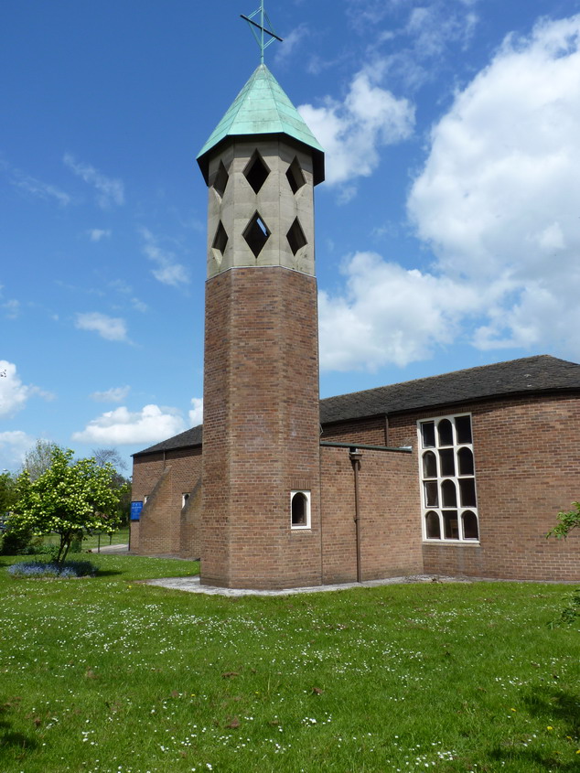
St Mary Magdalene's Church, Battlefield

St Mary Magdalene's Church is in the village of Battlefield, Shropshire, England, dedicated to Jesus' companion Mary Magdalene. It was built on the site...

Battlefield Heritage Park

Battlefield Heritage Park is a country park situated north of Shrewsbury in Shropshire, in the area known as Battlefield. It marks the supposed site of...

A5124 road

The A5124 is a road in Shropshire, England, that forms part of the northern section of the Shrewsbury by-pass. It is known locally as the Battlefield Link...

Shrewsbury Academy

Shrewsbury Academy is an 11-16 mixed secondary school with academy status in Shrewsbury, Shropshire, England. It was established in September 2016 following...

Sundorne

Sundorne is a suburb of the town of Shrewsbury, county town of Shropshire. It is located 2 km north of the town centre. The B5062 road begins at Heathgates...

Nearby Amenities

Located within 500m of 52.743284,-2.719884
Crossing
Crossing: unmarked
Crossing Island: no
Kerb: flush
Mapillary: 328816458592368
Survey Date: 2020-09-11
Tactile Paving: no
Wheelchair: yes
Lat/Long: 52.7466995/-2.7173252
Crossing
Crossing: unmarked
Crossing Island: no
Crossing Markings: no
Tactile Paving: no
Lat/Long: 52.7460701/-2.7182694
Barrier: stile
Lat/Long: 52.7458156/-2.7233719
Crossing
Crossing: unmarked
Crossing Island: no
Crossing Markings: no
Priority: backward
Tactile Paving: yes
Traffic Calming: choker
Lat/Long: 52.739495/-2.7162742
Fuel
BP
Addr Street: Robert Jones Way
Brand: BP
Brand Wikidata: Q152057
Brand Wikipedia: en:BP
Website: https://map.bp.com/en-GB/GB/petrol-station/shrewsbury/spar-battlefield/12389
Lat/Long: 52.747431/-2.7170993
Barrier: stile
Lat/Long: 52.7446214/-2.7155146
Barrier: stile
Lat/Long: 52.7445126/-2.7158563
Post Box
Operator: Royal Mail
Ref: SY1 763
Lat/Long: 52.7443053/-2.7193802
Battlefield
Place: suburb
Lat/Long: 52.7451302/-2.7191609
Power: tower
Lat/Long: 52.744433/-2.7166381
Power: tower
Lat/Long: 52.7413862/-2.7137949
Power: tower
Lat/Long: 52.7461814/-2.7212843
Fast Food
Subway
Addr Country: GB
Addr State: England
Addr Street: Robert Jones Way
Brand: Subway
Brand Wikidata: Q244457
Brand Wikipedia: en:Subway (restaurant)
Contact Website: https://restaurants.subway.com/united-kingdom/en/shrewsbury/spar-battlefield-roundabout-battlefield
Cuisine: sandwich
Drive Through: no
Outdoor Seating: no
Smoking: no
Takeaway: yes
Lat/Long: 52.7474117/-2.7174479
Spar
Addr Street: Robert Jones Way
Brand: Spar
Brand Wikidata: Q610492
Brand Wikipedia: en:Spar (retailer)
Shop: convenience
Website: https://www.spar.co.uk/store-locator/afb10624-spar-battlefield/
Lat/Long: 52.747329/-2.7174054
Noexit: yes
Lat/Long: 52.7405082/-2.7196779
Crossing
Crossing: unmarked
Crossing Island: no
Crossing Markings: no
Tactile Paving: yes
Lat/Long: 52.7415/-2.7197349
Mini Roundabout
Lat/Long: 52.7400338/-2.7230844
Crossing
Crossing: unmarked
Crossing Island: no
Crossing Markings: no
Tactile Paving: no
Lat/Long: 52.7460233/-2.7181311
Crossing
Crossing: unmarked
Crossing Island: no
Kerb: flush
Mapillary: 248032067279314
Survey Date: 2021-08-06
Tactile Paving: no
Wheelchair: yes
Lat/Long: 52.7461792/-2.7173555
Crossing
Crossing: unmarked
Crossing Island: no
Kerb: flush
Mapillary: 826356721390183
Survey Date: 2021-07-20
Tactile Paving: no
Wheelchair: yes
Lat/Long: 52.7462851/-2.717268
Crossing
Crossing: unmarked
Crossing Island: no
Kerb: flush
Tactile Paving: no
Lat/Long: 52.7463013/-2.7186578
Crossing
Crossing: unmarked
Crossing Island: no
Kerb: flush
Tactile Paving: no
Lat/Long: 52.7463904/-2.7187028
Crossing
Crossing: unmarked
Crossing Island: no
Kerb: flush
Tactile Paving: no
Lat/Long: 52.7468281/-2.7174819
Crossing
Crossing: unmarked
Crossing Island: no
Kerb: flush
Tactile Paving: no
Lat/Long: 52.7468853/-2.7184301
Crossing
Crossing: unmarked
Crossing Island: no
Tactile Paving: no
Lat/Long: 52.7469227/-2.7181066
Barrier: height_restrictor
Lat/Long: 52.7400714/-2.7232198
Compressed Air
Lat/Long: 52.7471657/-2.7178017
Julie Nicholas Florist
Addr City: Shrewsbury
Addr Housename: The Market Place
Addr Postcode: SY1 4AN
Addr Street: Battlefield Road
Phone: +44 1743 510237
Shop: florist
Website: https://www.julienicholasflorist.co.uk/
Lat/Long: 52.7404005/-2.7245384
Crossing
Crossing: uncontrolled
Crossing Markings: zebra
Lat/Long: 52.7416974/-2.7227295
Turning Circle
Lat/Long: 52.7430914/-2.7259595
Direction: backward
Traffic Calming: choker
Lat/Long: 52.7402933/-2.7176473
Fire Hydrant
Emergency: fire_hydrant
Fire Hydrant Type: underground
Survey Date: 2021-07-11
Lat/Long: 52.7390524/-2.7215288
Give Way
Direction: backward
Lat/Long: 52.7415753/-2.7197653
Barrier: bollard
Lat/Long: 52.7402538/-2.7204746
Bicycle Parking
Bicycle Parking: stands
Lat/Long: 52.7392212/-2.7222139
Recycling
Recycling Clothes: yes
Recycling Type: container
Lat/Long: 52.7391162/-2.7223268
Recycling
Recycling Clothes: yes
Recycling Type: container
Lat/Long: 52.7391/-2.7223415
Crossing
Crossing: unmarked
Crossing Island: yes
Crossing Markings: no
Tactile Paving: yes
Lat/Long: 52.7392639/-2.7230967
Fast Food
Subway
Addr City: Shrewsbury
Addr Country: GB
Addr Postcode: SY1 4AB
Addr Street: Battlefield Road
Addr Unit: Unit 5
Brand: Subway
Brand Wikidata: Q244457
Contact Website: https://restaurants.subway.com/united-kingdom/en/shrewsbury/unit-5-battlefield-road
Cuisine: sandwich
Fhrs Authority: Shropshire
Fhrs Id: 1023005
Fhrs Local Authority Id: 17/00524/COMM
Takeaway: yes
Lat/Long: 52.7401754/-2.7240194
Barrier: bollard
Bicycle: yes
Foot: yes
Motor Vehicle: no
Lat/Long: 52.7401172/-2.7229932
Barrier: kerb
Kerb: flush
Lat/Long: 52.7457523/-2.7185989
Crossing
Crossing: unmarked
Crossing Island: yes
Crossing Markings: no
Tactile Paving: yes
Lat/Long: 52.745772/-2.7186742
Barrier: kerb
Kerb: flush
Lat/Long: 52.7457899/-2.7187237
Barrier: kerb
Kerb: lowered
Lat/Long: 52.7460912/-2.7183635
Barrier: kerb
Kerb: lowered
Lat/Long: 52.7460077/-2.7180976
Crossing
Crossing: unmarked
Crossing Island: yes
Crossing Markings: no
Tactile Paving: yes
Lat/Long: 52.745658/-2.718699
Barrier: bollard
Lat/Long: 52.7452039/-2.7189376
Give Way
Lat/Long: 52.7460077/-2.7171742
Barrier: height_restrictor
Lat/Long: 52.7403536/-2.725463
Barrier: height_restrictor
Maxheight: 2.1
Lat/Long: 52.7398692/-2.7241155
Crossing
Crossing: marked
Crossing Markings: zebra
Crossing Ref: zebra
Traffic Calming: table
Lat/Long: 52.7402563/-2.7247874
Crossing
Crossing: marked
Crossing Markings: zebra
Crossing Ref: zebra
Traffic Calming: table
Lat/Long: 52.7401319/-2.7249253
Weighbridge
Lat/Long: 52.7416322/-2.7221971
Noexit: yes
Lat/Long: 52.7414739/-2.7206092
Noexit: yes
Lat/Long: 52.7413383/-2.7207125
Crossing
Crossing: uncontrolled
Crossing Markings: zebra
Lat/Long: 52.7412051/-2.7236208
Crossing
Crossing: uncontrolled
Crossing Markings: zebra
Lat/Long: 52.7417487/-2.7228746
Crossing
Crossing: unmarked
Crossing Island: yes
Crossing Markings: no
Tactile Paving: yes
Lat/Long: 52.7416651/-2.7201419
Give Way
Direction: backward
Lat/Long: 52.7416701/-2.7202166
Give Way
Direction: forward
Lat/Long: 52.7395334/-2.7163232
Give Way
Direction: backward
Lat/Long: 52.7402328/-2.7175125
The data included in this document is from www.openstreetmap.org. The data is made available under ODbL.

Have you been to Battlefield?

Leave your review of Battlefield below (or comments, questions and feedback).