Loch Garenin

Sea, Estuary, Creek in Ross-shire

Scotland

Loch Garenin

Blackhouse Village at Garenin
Blackhouse Village at Garenin Credit: Colin Park

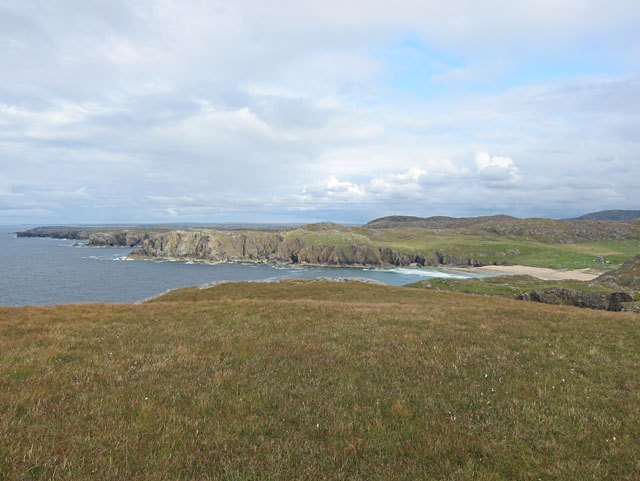
Loch Garenin is a picturesque body of water located in Ross-shire, Scotland. It is a sea loch, also known as an estuary or creek, where the sea water flows inward with the tides, forming a narrow and elongated body of water.

The loch is situated on the northwest coast of Scotland, near the village of Gairloch. It stretches approximately 5 miles from its mouth at the North Atlantic Ocean, gradually narrowing as it penetrates inland. The surrounding landscape is dominated by rugged hills and mountains, providing a stunning backdrop to the loch.

The waters of Loch Garenin are known for their rich marine life and natural beauty. The loch provides a vital habitat for various species of fish, including salmon and trout, making it a popular destination for anglers. Additionally, the area is frequented by a variety of seabirds, such as gulls and cormorants, which nest along the rocky shoreline.

The loch is also a popular spot for recreational activities, including boating, kayaking, and sailing. Its calm and sheltered waters make it an ideal location for water sports enthusiasts of all levels. Furthermore, the scenic beauty of Loch Garenin attracts many visitors who enjoy hiking along its shores or simply taking in the tranquil surroundings.

Overall, Loch Garenin offers a unique blend of natural beauty, diverse wildlife, and recreational opportunities, making it a must-visit destination for those exploring the Scottish Highlands.

If you have any feedback on the listing, please let us know in the comments section below.

Loch Garenin Images

Images are sourced within 2km of 58.297916/-6.7980134 or Grid Reference NB1844. Thanks to Geograph Open Source API. All images are credited.

Blackhouse Village at Garenin
Ruin by Loch Garenin
Bus shelter near the Tweed Mill
Na Gearrannan The main road through the restored part of the old village of blackhouses. People lived in some of these houses up until 1974.
Na Gearrannan
The main road through the restored part of the old village of blackhouses. People lived in some of these houses up until 1974.
Buildings in Gearrannan Blackhouse Village
The road to Gearrannan Blackhouse Village
Loch Garenin Sea loch below the Black House Village.
Loch Garenin
Sea loch below the Black House Village.
Blackhouse Village at Garenin The village was occupied until 1974. Restored in the later years of the Century. The plaque commemorates the opening of the village as a visitor attraction by Princess Anne. Most of the black houses are let as self-catering holiday accommodation.
Blackhouse Village at Garenin
The village was occupied until 1974. Restored in the later years of the Century. The plaque commemorates the opening of the village as a visitor attraction by Princess Anne. Most of the black houses are let as self-catering holiday accommodation.
Cottage interior, Garenin Blackhouse Village
Garenin Blackhouses Museum Group of reconstructed blackhouses which give an excellent impression of what Hebridean hamlets would have looked like 200 years ago.
Garenin Blackhouses Museum
Group of reconstructed blackhouses which give an excellent impression of what Hebridean hamlets would have looked like 200 years ago.
Garenin Blackhouses Museum A reconstructed blackhouse settlement.
Garenin Blackhouses Museum
A reconstructed blackhouse settlement.
Rubha Mor Neidallt illicit still Illicit still hidden below a large rock outcrop. <span class="nowrap"><a title="https://canmore.org.uk/site/137120/lewis-rubha-mor-neidallt" rel="nofollow ugc noopener" href="https://canmore.org.uk/site/137120/lewis-rubha-mor-neidallt">Link</a><img style="margin-left:2px;" alt="External link" title="External link - shift click to open in new window" src="https://s1.geograph.org.uk/img/external.png" width="10" height="10"/></span>
Rubha Mor Neidallt illicit still
Illicit still hidden below a large rock outcrop. LinkExternal link
Rubha Mor Neidallt illicit still View into the building from the rock outcrop above the building. <span class="nowrap"><a title="https://canmore.org.uk/site/137120/lewis-rubha-mor-neidallt" rel="nofollow ugc noopener" href="https://canmore.org.uk/site/137120/lewis-rubha-mor-neidallt">Link</a><img style="margin-left:2px;" alt="External link" title="External link - shift click to open in new window" src="https://s1.geograph.org.uk/img/external.png" width="10" height="10"/></span>
Rubha Mor Neidallt illicit still
View into the building from the rock outcrop above the building. LinkExternal link
Marker Cairn
Marker Cairn
Aird Mheadhonach cliffs, sheepfold and lazy beds
Historic shelter or shieling
Indented coast west of Dail Mòr The sandy beach is at Dail Mòr. Between this and the camera position there is another deeply incised inlet.
Indented coast west of Dail Mòr
The sandy beach is at Dail Mòr. Between this and the camera position there is another deeply incised inlet.
Show me another place!

Loch Garenin is located at Grid Ref: NB1844 (Lat: 58.297916, Lng: -6.7980134)

Unitary Authority: Na h-Eileanan an Iar

Police Authority: Highlands and Islands

What 3 Words

///proper.weekends.intensely. Near Carloway, Na h-Eileanan Siar

Related Wikis

Garenin

Garenin (Scottish Gaelic: Na Gearrannan) is a crofting township on the west coast of the Isle of Lewis in the Outer Hebrides of Scotland. Garenin is in...

Borrowston, Lewis

Borrowston (Scottish Gaelic: Borghastan), with a population of about 50, is a crofting township situated on the Isle of Lewis, on the Outer Hebrides of...

Carloway

Carloway (Scottish Gaelic: Càrlabhagh [ˈkʰaːɾɫ̪ə.ɤː]) is a crofting township and a district on the west coast of the Isle of Lewis, in the Outer Hebrides...

Dun Carloway

Dun Carloway (Scottish Gaelic: Dùn Chàrlabhaigh) is a broch situated in the district of Carloway, on the west coast of the Isle of Lewis, Scotland (grid...

Nearby Amenities

Located within 500m of 58.297916,-6.7980134
Gearrannan Blackhouse Village
Addr City: Eilean Leòdhais
Addr City En: Isle of Lewis
Addr Country: GB
Addr Housenumber: 5a
Addr Postcode: HS2 9AL
Addr Street: Gearrannan
Fee: yes
Fhrs Id: 806576
Museum: local
Opening Hours: Mo-Sa 11:00-17:30
Tourism: museum
Website: http://www.gearrannan.com/
Lat/Long: 58.2963356/-6.7917318
Tourism: hostel
Lat/Long: 58.2965108/-6.7924693
Carloway
Naptan AtcoCode: 6010731591
Naptan Bearing: SE
Naptan BusStopType: CUS
Naptan CommonName: Carloway
Naptan Indicator: Garenin Village
Naptan Landmark: Garenin village tourist attraction
Naptan NaptanCode: 94723968
Naptan Street: Garenin Village
Naptan Verified: no
Source: naptan_import
Lat/Long: 58.2963114/-6.7909189
Cafe
Geàrrannan Blackhouse Village Cafe
Opening Hours: Mo-Sa 11:00-17:00
Lat/Long: 58.2962777/-6.7916702
Generator Method: wind_turbine
Generator Source: wind
Generator Type: horizontal_axis
Power: generator
Lat/Long: 58.2984036/-6.7911661
Generator Method: wind_turbine
Generator Source: wind
Generator Type: horizontal_axis
Power: generator
Lat/Long: 58.2983247/-6.7908174
Generator Method: wind_turbine
Generator Source: wind
Generator Type: horizontal_axis
Power: generator
Lat/Long: 58.2980569/-6.7912224
Generator Method: wind_turbine
Generator Source: wind
Generator Type: horizontal_axis
Power: generator
Lat/Long: 58.2977553/-6.7911956
Material: wood
Power: pole
Lat/Long: 58.2962719/-6.7902364
Entrance: yes
Lat/Long: 58.296321/-6.7918032
Entrance: yes
Lat/Long: 58.2962639/-6.7916518
Entrance: yes
Lat/Long: 58.2964898/-6.792478
Entrance: yes
Lat/Long: 58.2964902/-6.7929898
Access: permissive
Drinking Water: yes
Man Made: water_tap
Lat/Long: 58.2963612/-6.7924608
Toilets
Fee: no
Lat/Long: 58.296462/-6.7929788
Loch Garenin
Natural: bay
Lat/Long: 58.2974423/-6.7972235
The data included in this document is from www.openstreetmap.org. The data is made available under ODbL.

Have you been to Loch Garenin?

Leave your review of Loch Garenin below (or comments, questions and feedback).