Bay Craavat

Sea, Estuary, Creek in Inverness-shire

Scotland

Bay Craavat

Pony and ruin, Carinish
Pony and ruin, Carinish Credit: Hugh Venables

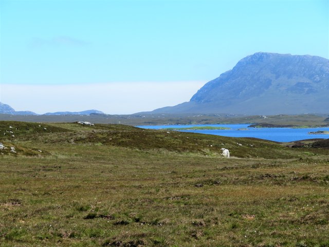
Bay Craavat is a scenic coastal area located in Inverness-shire, Scotland. Situated along the western coast, it encompasses a sea, an estuary, and a creek, providing visitors with a captivating blend of natural beauty and marine biodiversity.

The bay itself boasts stunning views of the North Atlantic Ocean, with its crystal-clear waters glistening under the Scottish sun. The sandy shores offer an inviting spot for beachcombing, picnicking, and enjoying the sound of the waves crashing against the shore. The bay's expansive beach is also a popular destination for water sports enthusiasts, who can partake in activities such as surfing, kayaking, and windsurfing.

The estuary, formed by the convergence of a river and the ocean, adds another dimension to Bay Craavat's charm. This brackish water habitat provides a haven for a variety of marine life, including fish, crustaceans, and numerous bird species. Birdwatchers flock to the area to catch glimpses of migratory birds and local residents, such as herons, gulls, and cormorants.

Nestled within the bay is a picturesque creek, meandering through the surrounding landscape. The creek's tranquil waters provide an excellent environment for fishing, both for recreational anglers and local fishermen. Its sheltered nature also makes it an ideal spot for boating and sailing, allowing visitors to explore the bay from a different perspective.

Overall, Bay Craavat in Inverness-shire offers a diverse and captivating coastal experience, combining a scenic sea, a vibrant estuary, and a peaceful creek. Whether it's for relaxation, outdoor activities, or wildlife observation, this coastal gem has something to offer to every visitor.

If you have any feedback on the listing, please let us know in the comments section below.

Bay Craavat Images

Images are sourced within 2km of 57.515315/-7.2877434 or Grid Reference NF8359. Thanks to Geograph Open Source API. All images are credited.

Pony and ruin, Carinish
End of the road at Àird Mhòr
House at Carinish
House at Carinish
Marshy area at Carinish Seemingly a naturally infilled loch.
Marshy area at Carinish
Seemingly a naturally infilled loch.
Blar Chairinis Site of battle in 1601.
Blar Chairinis
Site of battle in 1601.
Ocean on the west side of the causeway to North Uist
Gairbh-eilean
Gairbh-eilean
Barp Hacklett Cairn One cannot be absolutely sure if this is the cairn as the OS map doesn't give a detailed site, but as it is the only pile of stones on a green protuberance on an otherwise rather squelchy moor, then one would suggest that this is it.
Barp Hacklett Cairn
One cannot be absolutely sure if this is the cairn as the OS map doesn't give a detailed site, but as it is the only pile of stones on a green protuberance on an otherwise rather squelchy moor, then one would suggest that this is it.
Moorcroft Campsite at low tide
Field and houses at Carinish And also the site of Feith na Fala (The ditch of blood) - a battle waged in 1601 between the MacLeods and the MacDonalds.
Field and houses at Carinish
And also the site of Feith na Fala (The ditch of blood) - a battle waged in 1601 between the MacLeods and the MacDonalds.
Bagh a’ Ghriasaiche
Bagh a’ Ghriasaiche
Fèithe na Fala - The ditch of blood
Free Church, Cairinis Current OS maps show this as a church, but older versions show it as a pub, which was its original purpose. Enough said.
Free Church, Cairinis
Current OS maps show this as a church, but older versions show it as a pub, which was its original purpose. Enough said.
A not very useful gate A rusty old metal gate at the point where a fence once crossed the track.
A not very useful gate
A rusty old metal gate at the point where a fence once crossed the track.
Track above Loch Creag nan Speireag This track, which is indistinct in places, forms part of the Hebridean Way, a relatively new walking route through the Western Isles.
Track above Loch Creag nan Speireag
This track, which is indistinct in places, forms part of the Hebridean Way, a relatively new walking route through the Western Isles.
Cotton grass, Creag nan Speireag Looking over cotton grass towards Loch nan Speireag and the houses at Gearraidh Cladach.
Cotton grass, Creag nan Speireag
Looking over cotton grass towards Loch nan Speireag and the houses at Gearraidh Cladach.
East from Creag nan Speireag Some 200m from the Hebridean Way path which probably cuts the corner of this square and provides some very 'soft' walking over damp moors. This diversion to a low rise gives a view eastwards towards the oddly shaped Loch Carabhat and distant Eabhal.
East from Creag nan Speireag
Some 200m from the Hebridean Way path which probably cuts the corner of this square and provides some very 'soft' walking over damp moors. This diversion to a low rise gives a view eastwards towards the oddly shaped Loch Carabhat and distant Eabhal.
View towards Beinn na Coille Although this view is across the tiny Loch na Meirle, it remains hidden from sight in a small fold of the moor. Further progress into this square was made difficult by soft ground through old peat workings.
View towards Beinn na Coille
Although this view is across the tiny Loch na Meirle, it remains hidden from sight in a small fold of the moor. Further progress into this square was made difficult by soft ground through old peat workings.
Show me another place!

Bay Craavat is located at Grid Ref: NF8359 (Lat: 57.515315, Lng: -7.2877434)

Unitary Authority: Na h-Eileanan an Iar

Police Authority: Highlands and Islands

What 3 Words

///heartless.wiser.lushly. Near Balivanich, Na h-Eileanan Siar

Related Wikis

Carinish

Carinish (Scottish Gaelic: Càirinis), is a hamlet on North Uist, in the Outer Hebrides, Scotland. It is in the south of the island, about two miles (three...

Bail' Iochdrach

Bail' Iochdrach or Baliochrach (Scottish Gaelic: Am Baile Ìochdrach) is a village on Benbecula in the Outer Hebrides, Scotland. Baliochrach is within the...

Battle of Carinish

The Battle of Carinish was a Scottish clan battle fought in North Uist in 1601. It was part of a year of feuding between Clan MacLeod of Dunvegan and the...

Teampull na Trionaid

Teampull na Trionaid ("trinity church") is a ruined 13th-century Augustinian nunnery at Carinish, on North Uist, in the Outer Hebrides of Scotland. �...

Baile Glas

Baile Glas or Ballaglasa (Scottish Gaelic: Am Baile Glas) is a settlement on Grimsay in the Outer Hebrides, Scotland. Ballaglasa is within the parish of...

Fraoch-Eilean

Fraoch-eilean is a small island with an uncertain population north of Benbecula in the Outer Hebrides of Scotland. It is about 55 hectares (140 acres...

Grimsay

Grimsay (Scottish Gaelic: Griomasaigh) is a tidal island in the Outer Hebrides of Scotland. == Geography == Grimsay is the largest of the low-lying stepping...

Flodaigh

Flodaigh is a tidal island lying to the north of Benbecula and south of Grimsay in the Outer Hebrides, Scotland. It is connected to Benbecula by a causeway...

Nearby Amenities

Located within 500m of 57.515315,-7.2877434
Barrier: cattle_grid
Lat/Long: 57.5183997/-7.2832332
Carinish Crofting Woodland
Board Type: history
Information: board
Tourism: information
Lat/Long: 57.5198097/-7.2877845
Description: Hebriden Way. Pointing W Grimsay 1.8 miles. Pointing N, Locheport 2.8 miles
Hiking: yes
Information: guidepost
Tourism: information
Lat/Long: 57.5195637/-7.2878797
Power: pole
Lat/Long: 57.5195378/-7.2870496
Power: pole
Lat/Long: 57.519218/-7.2854295
Power: pole
Lat/Long: 57.5188911/-7.2839704
Power: pole
Lat/Long: 57.5186995/-7.2830665
Power: pole
Lat/Long: 57.518433/-7.2818166
Power: pole
Lat/Long: 57.5164754/-7.2847912
Power: pole
Lat/Long: 57.516147/-7.2846892
Power: pole
Lat/Long: 57.5161715/-7.2836137
Barrier: cattle_grid
Lat/Long: 57.5184802/-7.2861367
Power: pole
Lat/Long: 57.5167491/-7.2820714
Power: pole
Lat/Long: 57.5168874/-7.2807062
Power: pole
Lat/Long: 57.5166065/-7.2834635
Barrier: cattle_grid
Lat/Long: 57.5161744/-7.2834373
Power: pole
Lat/Long: 57.5156219/-7.2853062
Power: pole
Lat/Long: 57.5150428/-7.2851318
Power: pole
Lat/Long: 57.5144392/-7.2865614
Power: pole
Lat/Long: 57.513935/-7.2877738
Power: pole
Lat/Long: 57.5151595/-7.2839007
The data included in this document is from www.openstreetmap.org. The data is made available under ODbL.

Have you been to Bay Craavat?

Leave your review of Bay Craavat below (or comments, questions and feedback).