Campbeltown Loch

Sea, Estuary, Creek in Argyllshire

Scotland

Campbeltown Loch

Looking to Davaar House across Kildalloig Bay
Looking to Davaar House across Kildalloig Bay Credit: Alpin Stewart

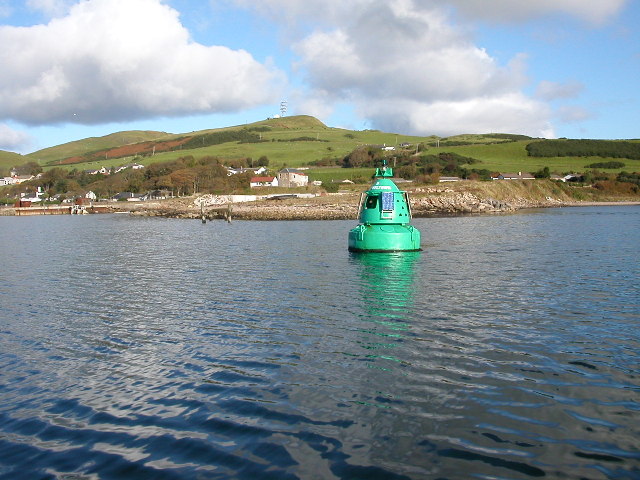
Campbeltown Loch is a picturesque sea loch located in Argyllshire, Scotland. Nestled on the western coast of the Kintyre Peninsula, it stretches for approximately 11 kilometers from its entrance at the Sound of Bute to the town of Campbeltown at its head. The loch is formed by the confluence of the River Kilkerran and the River Lussa, which flow into the loch and eventually out into the Atlantic Ocean.

The loch's natural beauty is a result of its stunning surroundings. To the east, the loch is bordered by rolling hills and mountains, providing a dramatic backdrop to the serene waters. To the west, the loch opens up to the vast expanse of the Atlantic, with views extending to the islands of Gigha and Islay on clear days.

Campbeltown Loch is renowned for its rich marine life and is a popular spot for fishing and angling enthusiasts. The loch is home to a variety of fish species, including salmon, trout, and sea bass. Its sheltered waters also attract a wide range of seabirds, making it a haven for birdwatchers.

The town of Campbeltown, located at the head of the loch, is a vibrant hub with a rich maritime history. It was once a thriving fishing and shipbuilding center, and remnants of its industrial past can still be seen along the waterfront. Today, the town offers a range of amenities and attractions for visitors, including a picturesque harbor, traditional pubs, and distilleries producing the famous Campbeltown single malt whisky.

Overall, Campbeltown Loch in Argyllshire is a hidden gem that offers a tranquil escape into the natural beauty of Scotland's west coast.

If you have any feedback on the listing, please let us know in the comments section below.

Campbeltown Loch Images

Images are sourced within 2km of 55.424332/-5.5768817 or Grid Reference NR7320. Thanks to Geograph Open Source API. All images are credited.

Looking to Davaar House across Kildalloig Bay
Kilkerran Road, Campbeltown
Looking over to Campbeltown
Course of Kilkerran Burn, Argyll Kilkerran Burn flows for approximately 1.3km from Crosshill Loch to the sea near the site of Kilkerran Castle.  Here it is passing through Kilkerran Cemetery.
Course of Kilkerran Burn, Argyll
Kilkerran Burn flows for approximately 1.3km from Crosshill Loch to the sea near the site of Kilkerran Castle. Here it is passing through Kilkerran Cemetery.
Abandoned boat by Campbeltown Loch, Argyll Looking towards the pier at Campbeltown Naval Oil Fuel Depot and Island Davaar beyond.
Abandoned boat by Campbeltown Loch, Argyll
Looking towards the pier at Campbeltown Naval Oil Fuel Depot and Island Davaar beyond.
Shore, Kildalloig Bay
Sheep Pasture, Kildalloig Bay
Main Street As the name suggests, this is Campbeltown's principal shopping street. Much of the north side (on the left) is Category C Listed.
Main Street
As the name suggests, this is Campbeltown's principal shopping street. Much of the north side (on the left) is Category C Listed.
Campbeltown Loch Pontoons and moorings have been provided in the shelter of the Old Quay.
Campbeltown Loch
Pontoons and moorings have been provided in the shelter of the Old Quay.
Campbeltown Harbour Fishing boats in the shelter of the Old Quay on Campbeltown Loch.
Campbeltown Harbour
Fishing boats in the shelter of the Old Quay on Campbeltown Loch.
Former Lowland Kirk The building dates from 1706 but was extensively restored in 1904. It is a Category B Listed Building. See <span class="nowrap"><a title="http://portal.historicenvironment.scot/designation/LB22944" rel="nofollow ugc noopener" href="http://portal.historicenvironment.scot/designation/LB22944">Link</a><img style="margin-left:2px;" alt="External link" title="External link - shift click to open in new window" src="https://s1.geograph.org.uk/img/external.png" width="10" height="10"/></span> for its history and a detailed description.
Former Lowland Kirk
The building dates from 1706 but was extensively restored in 1904. It is a Category B Listed Building. See LinkExternal link for its history and a detailed description.
Masonic Hall Lodge St John's No 141. It does not seem to be a Listed building.
Masonic Hall
Lodge St John's No 141. It does not seem to be a Listed building.
Town Hall The 18th century Town Hall has a distinctive octagonal spire. It is a Category B Listed building. See <span class="nowrap"><a title="http://portal.historicenvironment.scot/designation/LB22918" rel="nofollow ugc noopener" href="http://portal.historicenvironment.scot/designation/LB22918">Link</a><img style="margin-left:2px;" alt="External link" title="External link - shift click to open in new window" src="https://s1.geograph.org.uk/img/external.png" width="10" height="10"/></span> for full details and history.
Town Hall
The 18th century Town Hall has a distinctive octagonal spire. It is a Category B Listed building. See LinkExternal link for full details and history.
Telecommunications Masts Prominently sited east of Campbeltown.
Telecommunications Masts
Prominently sited east of Campbeltown.
Lorne and Lowland Church, Longrow, Campbeltown, Argyll The church dates from 1869 and was designed by architect John Burnet.  It is category B listed.
Lorne and Lowland Church, Longrow, Campbeltown, Argyll
The church dates from 1869 and was designed by architect John Burnet. It is category B listed.
Campbeltown telephone exchange Construction work on the new telephone exchange started in 1937 and the automatic exchange opened for service on 7 June 1939.
Campbeltown telephone exchange
Construction work on the new telephone exchange started in 1937 and the automatic exchange opened for service on 7 June 1939.
Apartment block in Dalintober On High Street.
Apartment block in Dalintober
On High Street.
23 High Street, Dalintober, Campbeltown Opposite the Glen Scotia Distillery.
23 High Street, Dalintober, Campbeltown
Opposite the Glen Scotia Distillery.
Show me another place!

Campbeltown Loch is located at Grid Ref: NR7320 (Lat: 55.424332, Lng: -5.5768817)

Unitary Authority: Argyll and Bute

Police Authority: Argyll and West Dunbartonshire

What 3 Words

///frosted.roughness.clever. Near Campbeltown, Argyll & Bute

Related Wikis

Campbeltown Loch

Campbeltown Loch (Scottish Gaelic: Loch Chille Chiarain) is a small sea loch near the south of the Kintyre Peninsula facing eastwards towards the Firth...
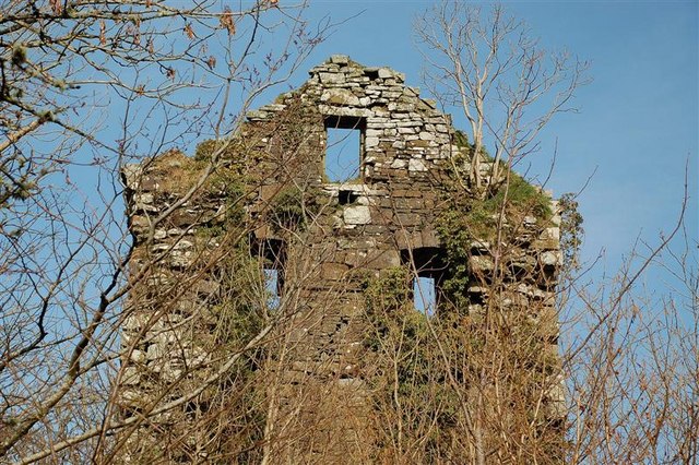
Kilkerran Castle

Kilkerran Castle is a ruined castle, near Campbeltown, Kintyre, Argyll and Bute, Scotland. == History == A keep was built in 1490 by King James IV, for...

Moil Castle, Argyll and Bute

Moil Castle was a castle near Campbeltown, Kintyre, Scotland. It was a stronghold of Clan Donald. == Notes == == References == Coventry, Martin (2010)...

SS Ypiranga

S.S. Ypiranga was a German-registered passenger/cargo steamer owned and operated by Hamburg-America Line (Hapag-Lloyd) shipping company. It was built in...

Nearby Amenities

Located within 500m of 55.424332,-5.5768817
Ford: yes
Lat/Long: 55.427005/-5.5751811
Power: pole
Lat/Long: 55.4283017/-5.5802066
Power: pole
Lat/Long: 55.4277776/-5.5804101
Power: pole
Lat/Long: 55.4273252/-5.5806516
The data included in this document is from www.openstreetmap.org. The data is made available under ODbL.

Have you been to Campbeltown Loch?

Leave your review of Campbeltown Loch below (or comments, questions and feedback).