Beddmanarch Bay

Bay in Anglesey

Wales

Beddmanarch Bay

Sea kayaking on the Inland Sea With the chimney of Anglesey Aluminium.
Sea kayaking on the Inland Sea Credit: Mat Fascione

Beddmanarch Bay is a picturesque sandy bay located on the northeastern coast of Anglesey, an island off the northwestern coast of Wales. Situated between Cemaes Bay and Church Bay, this small but charming bay offers stunning natural beauty and tranquil surroundings.

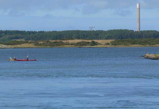
The bay is known for its pristine sandy beach, which stretches for approximately 500 meters. The fine golden sand and crystal-clear waters make it a popular destination for beachgoers, families, and water sports enthusiasts. The beach offers plenty of space for sunbathing, picnicking, and building sandcastles, while the calm waters provide opportunities for swimming, paddleboarding, and kayaking.

Surrounded by rugged cliffs and rocky outcrops, Beddmanarch Bay offers breathtaking views of the Irish Sea. The bay's location makes it a perfect spot for birdwatching, as it attracts a variety of seabirds, including oystercatchers, gulls, and cormorants. The coastal path that runs along the bay is a favorite among hikers and nature lovers, offering panoramic vistas and the chance to spot seals and dolphins in the distance.

Facilities at Beddmanarch Bay are limited, with no lifeguard services or public toilets available. However, a small car park nearby provides convenient access to the bay. Visitors can also find accommodation options and amenities in the nearby villages of Cemaes Bay and Church Bay.

Overall, Beddmanarch Bay is a hidden gem on the Anglesey coastline, offering a peaceful and idyllic retreat for those seeking natural beauty and tranquility.

If you have any feedback on the listing, please let us know in the comments section below.

Beddmanarch Bay Images

Images are sourced within 2km of 53.296062/-4.5868105 or Grid Reference SH2780. Thanks to Geograph Open Source API. All images are credited.

Sea kayaking on the Inland Sea With the chimney of Anglesey Aluminium.
Sea kayaking on the Inland Sea
With the chimney of Anglesey Aluminium.
A5 and bus stop by Old foundry just east of Stanley embankment
Foundry Crossing The 6.55am  Holyhead - Euston service passing through Foundry Crossing, Y Fali
Foundry Crossing
The 6.55am Holyhead - Euston service passing through Foundry Crossing, Y Fali
Y Fali / Valley Police Station for sale The former police station on the A5 heading towards Holyhead now up for sale.
Could make a unique conversion!
Y Fali / Valley Police Station for sale
The former police station on the A5 heading towards Holyhead now up for sale. Could make a unique conversion!
The A55 North Wales Expressway At Stanley Embankment.
The A55 North Wales Expressway
At Stanley Embankment.
The Stanley Embankment The Stanley Embankment that connects the Isle of Anglesey and Holy Island.
The Stanley Embankment
The Stanley Embankment that connects the Isle of Anglesey and Holy Island.
Stanley Embankment Embankment that connects the Island of Anglesey and Holy Island. It was completed in 1823 and is 1,170 metres in length.
Stanley Embankment
Embankment that connects the Island of Anglesey and Holy Island. It was completed in 1823 and is 1,170 metres in length.
Stanley Embankment Tyre Dealers The former ATS tyre dealership on the Stanley Embankment appears to have ceased trading.
Stanley Embankment Tyre Dealers
The former ATS tyre dealership on the Stanley Embankment appears to have ceased trading.
Cycle Route 8 seen across the A5
The A5 at Hên-Valley
Canoes for sale!
Canoes for sale!
The Betting Stand ( aka Rotten Tower ) ** The Penrhos estate was the principal seat on Holy Island and became the home of the Stanley family in 1763. Penrhos house was completely remodelled for John Thomas Stanley in early C19; the Betting Stand is probably contemporary with this remodelling, built as a point from which to view horse racing on a private course. Possibly originally part of the work carried out by Margaret Owen who is said to have 'planted the pleasure gardens'
** Courtesy Cadw
The Betting Stand ( aka Rotten Tower )
** The Penrhos estate was the principal seat on Holy Island and became the home of the Stanley family in 1763. Penrhos house was completely remodelled for John Thomas Stanley in early C19; the Betting Stand is probably contemporary with this remodelling, built as a point from which to view horse racing on a private course. Possibly originally part of the work carried out by Margaret Owen who is said to have 'planted the pleasure gardens' ** Courtesy Cadw
Bailiffs Tower at Penrhos Home Farm **The Penrhos estate was the principal seat on Holy Island and became the home of the Stanley family in 1763. Penrhos House was completely remodelled for John Thomas Stanley in early C19; the Bailiffs Tower (part of the Home Farm) is probably contemporary with this remodelling, built c1802-8.
A Grade II Listed Building.
Listed as a striking example of a C19 estate building in the castellated style characteristic of the Penrhos estate buildings of this period; part of a group with the barn and cartsheds at Penrhos Home Farm.
** Courtesy Cadw
Bailiffs Tower at Penrhos Home Farm
**The Penrhos estate was the principal seat on Holy Island and became the home of the Stanley family in 1763. Penrhos House was completely remodelled for John Thomas Stanley in early C19; the Bailiffs Tower (part of the Home Farm) is probably contemporary with this remodelling, built c1802-8. A Grade II Listed Building. Listed as a striking example of a C19 estate building in the castellated style characteristic of the Penrhos estate buildings of this period; part of a group with the barn and cartsheds at Penrhos Home Farm. ** Courtesy Cadw
Trefignath Neolithic Burial Chamber <span class="nowrap"><a title="https://www.megalithic.co.uk/article.php?sid=4441" rel="nofollow ugc noopener" href="https://www.megalithic.co.uk/article.php?sid=4441">Link</a><img style="margin-left:2px;" alt="External link" title="External link - shift click to open in new window" src="https://s1.geograph.org.uk/img/external.png" width="10" height="10"/></span>
Trefignath Neolithic Burial Chamber
Trefignath Burial Chamber, SE of Holyhead
Coffee Cups Cafe, near Stanley Embankment An ex A5 Toll House moved brick by brick in the 1970s (from Stamley Gate  SH 27587 80329) to allow the original ex turnpike to be bypassed. It served the Shrewsbury to Holyhead Turnpike Trust in the 18ᵗʰC.

Milestone Society National ID: ANG.PRH
Coffee Cups Cafe, near Stanley Embankment
An ex A5 Toll House moved brick by brick in the 1970s (from Stamley Gate SH 27587 80329) to allow the original ex turnpike to be bypassed. It served the Shrewsbury to Holyhead Turnpike Trust in the 18ᵗʰC. Milestone Society National ID: ANG.PRH
Old Milestone by the A5, Penrhos Coastal Park, Beddmanarch Bay Telford Plate by the A5, London Road in parish of Trearddur (Anglesey District), Penrhos Coastal Park; Beddmanarch Bay, North end of Stanley Embankment.

Inscription reads:-
HOLY-
HEAD
3
MONA
10
BANGOR
22

Grade II listed by Cadw.
Reference Number 20073: <span class="nowrap"><a title="https://cadwpublic-api.azurewebsites.net/reports/listedbuilding/FullReport?lang=&id=20073" rel="nofollow ugc noopener" href="https://cadwpublic-api.azurewebsites.net/reports/listedbuilding/FullReport?lang=&id=20073">Link</a><img style="margin-left:2px;" alt="External link" title="External link - shift click to open in new window" src="https://s1.geograph.org.uk/img/external.png" width="10" height="10"/></span>

Surveyed

Milestone Society National ID: ANG_HH03
Old Milestone by the A5, Penrhos Coastal Park, Beddmanarch Bay
Telford Plate by the A5, London Road in parish of Trearddur (Anglesey District), Penrhos Coastal Park; Beddmanarch Bay, North end of Stanley Embankment. Inscription reads:- HOLY- HEAD 3 MONA 10 BANGOR 22 Grade II listed by Cadw. Reference Number 20073: LinkExternal link Surveyed Milestone Society National ID: ANG_HH03
Anglesey Coast Path After leaving Newlands Park, the path joins the A5 Holyhead Road west of Valley to cross the Cob, or Stanley Embankment, which joins Holy Island to the rest of Anglesey.  This row of houses are just east of where the path joins the A5.
Anglesey Coast Path
After leaving Newlands Park, the path joins the A5 Holyhead Road west of Valley to cross the Cob, or Stanley Embankment, which joins Holy Island to the rest of Anglesey. This row of houses are just east of where the path joins the A5.
Show me another place!

Beddmanarch Bay is located at Grid Ref: SH2780 (Lat: 53.296062, Lng: -4.5868105)

Unitary Authority: Isle of Anglesey

Police Authority: North Wales

What 3 Words

///zoned.prospers.gazed. Near Valley, Isle of Anglesey

Nearby Locations

Beddmanarch Bay

Related Wikis

Anglesey Aluminium

Anglesey Aluminium was a joint venture between Rio Tinto and Kaiser Aluminum. Its aluminium smelter, located on the outskirts of Holyhead, was one of the...

Penrhos Country Park

Penrhos Country Park (also known as Penrhos Coastal Park) (grid reference SH2781) is a country park near Holyhead, on the island of Anglesey in Wales,...

Stanley Embankment

The Stanley Embankment (known locally as the Cob) is a railway, road and cycleway embankment that crosses the Cymyran Strait in Wales, connecting the Island...

Penrhos, Anglesey

Penrhos was a large estate on Holy Island, Anglesey, in north-west Wales. == History == In 1553, during Edward VI's reign, Penrhos was granted to John...

Nearby Amenities

Located within 500m of 53.296062,-4.5868105
Source: PGS
Lat/Long: 53.2922575/-4.5881645
Source: PGS
Lat/Long: 53.2928311/-4.5886414
Source: PGS
Lat/Long: 53.3004843/-4.5866845
Source: PGS
Lat/Long: 53.3002102/-4.5869656
Source: PGS
Lat/Long: 53.2999274/-4.5875535
Source: PGS
Lat/Long: 53.2996643/-4.5880916
Source: PGS
Lat/Long: 53.2994477/-4.5883535
Source: PGS
Lat/Long: 53.297334/-4.5888299
Source: PGS
Lat/Long: 53.296314/-4.5890268
Source: PGS
Lat/Long: 53.2957691/-4.5887326
Source: PGS
Lat/Long: 53.2949759/-4.5891714
Source: PGS
Lat/Long: 53.2946488/-4.5891956
Source: PGS
Lat/Long: 53.2942532/-4.5888538
Source: PGS
Lat/Long: 53.2938861/-4.5888184
Man Made: flagpole
Lat/Long: 53.2962367/-4.5892155
Cafe
Coffee Cups
Diet Vegan: no
Diet Vegetarian: yes
Opening Hours: Mo-Su 11:00-16:00
Lat/Long: 53.2925019/-4.5888101
Source: PGS
Lat/Long: 53.2980747/-4.5884188
Source: PGS
Lat/Long: 53.2978188/-4.5882643
Bench
Backrest: yes
Lat/Long: 53.297069/-4.589204
Bench
Lat/Long: 53.2948959/-4.5894425
Bench
Lat/Long: 53.295026/-4.5894454
Bench
Backrest: no
Lat/Long: 53.2992063/-4.588897
Stop
Direction: forward
Stop: minor
Lat/Long: 53.2917596/-4.5882234
The data included in this document is from www.openstreetmap.org. The data is made available under ODbL.

Have you been to Beddmanarch Bay?

Leave your review of Beddmanarch Bay below (or comments, questions and feedback).