Maidenhead Bay

Bay in Wigtownshire

Scotland

Maidenhead Bay

End of Clifftop Walk from Port Logan It is rare to see a yellow waymarker pointing straight down.  This one means 'turn back'.
There is no easy way beyond this point.
End of Clifftop Walk from Port Logan Credit: Rose and Trev Clough

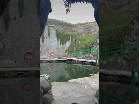
Maidenhead Bay is a picturesque bay located in the Wigtownshire region of southwest Scotland. Situated on the eastern coast of the Rhins of Galloway peninsula, this beautiful bay stretches for approximately 2 miles along the Irish Sea. It is nestled between the towns of Portpatrick to the north and Drummore to the south.

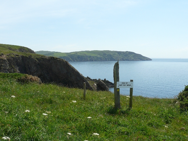
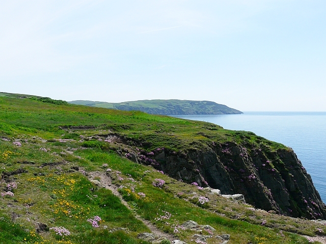
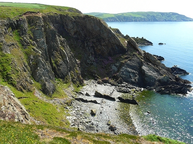
The bay is renowned for its stunning natural beauty, characterized by its golden sandy beach, clear turquoise waters, and rocky cliffs that border its edges. The beach is well-maintained and offers visitors a tranquil spot for relaxation and various recreational activities such as sunbathing, picnicking, and beachcombing. The bay is also a popular destination for coastal walks and is part of the Rhins Coastal Path.

Maidenhead Bay boasts a rich marine life, attracting nature enthusiasts and wildlife watchers. Seals can often be spotted basking on the rocks, and a variety of seabirds, including gannets, fulmars, and kittiwakes, can be seen soaring above the bay. The bay is also home to a diverse range of fish species, making it a popular spot for fishing enthusiasts.

For those interested in history, Maidenhead Bay holds significance as the location of the wreck of the SS Lennie, a cargo ship that sank in 1914. The remains of the ship can still be seen at low tide, attracting history buffs and divers.

With its breathtaking scenery, abundant wildlife, and historical significance, Maidenhead Bay is a must-visit destination for nature lovers and anyone seeking a peaceful coastal retreat in the Wigtownshire region.

If you have any feedback on the listing, please let us know in the comments section below.

Maidenhead Bay Images

Images are sourced within 2km of 54.730082/-4.9637392 or Grid Reference NX0941. Thanks to Geograph Open Source API. All images are credited.

End of Clifftop Walk from Port Logan It is rare to see a yellow waymarker pointing straight down.  This one means 'turn back'.
There is no easy way beyond this point.
End of Clifftop Walk from Port Logan
It is rare to see a yellow waymarker pointing straight down. This one means 'turn back'. There is no easy way beyond this point.
Path from Cairnywellan Head An unofficial footpath that comes to an abrupt halt a little further south <a href="https://www.geograph.org.uk/photo/838279">NX0939 : End of Clifftop Walk from Port Logan</a> .
Path from Cairnywellan Head
An unofficial footpath that comes to an abrupt halt a little further south NX0939 : End of Clifftop Walk from Port Logan .
Cliffs overlooking Slate Heugh Bay The rock is greywacke of Early Silurian age.
Cliffs overlooking Slate Heugh Bay
The rock is greywacke of Early Silurian age.
Slate Heugh Bay The cliffs here are composed of greywacke, a sedimentary rock, laid down in the Early Silurian period. In the bay a jagged line of upstanding rock crosses the shore from the sea, and appears to continue as a white line all the way up the cliff. This is a later intrusion of hard igneous rock, and is mentioned in the British Geological Survey's excursion guide to the area <span class="nowrap"><a title="http://shop.bgs.ac.uk/Bookshop/product.cfm?p_id=GSWS" rel="nofollow ugc noopener" href="http://shop.bgs.ac.uk/Bookshop/product.cfm?p_id=GSWS">Link</a><img style="margin-left:2px;" alt="External link" title="External link - shift click to open in new window" src="https://s1.geograph.org.uk/img/external.png" width="10" height="10"/></span> as "a cross-cutting, Tertiary dolerite dyke".
Slate Heugh Bay
The cliffs here are composed of greywacke, a sedimentary rock, laid down in the Early Silurian period. In the bay a jagged line of upstanding rock crosses the shore from the sea, and appears to continue as a white line all the way up the cliff. This is a later intrusion of hard igneous rock, and is mentioned in the British Geological Survey's excursion guide to the area LinkExternal link as "a cross-cutting, Tertiary dolerite dyke".
Farm quarry A convenient source of easily-worked stone. This band of slatey rock, part of the Silurian Gala Group of greywackes, runs across the Rhins and is worked in several places. See <a href="https://www.geograph.org.uk/photo/3141425">NX1139 : Quarry lakes</a> for another. In this image the bedding of the rocks is very clear, steep and northerly, and that is a regional trend reflecting the collision of continents in the Caledonian orogeny.
Farm quarry
A convenient source of easily-worked stone. This band of slatey rock, part of the Silurian Gala Group of greywackes, runs across the Rhins and is worked in several places. See NX1139 : Quarry lakes for another. In this image the bedding of the rocks is very clear, steep and northerly, and that is a regional trend reflecting the collision of continents in the Caledonian orogeny.
Please shut the gate An excellent reminder in colloqial Scots that closing the gate behind you is important under all circumstances. The animals that occasion the reminder are clustered on the hill overlooking Port Logan.
Please shut the gate
An excellent reminder in colloqial Scots that closing the gate behind you is important under all circumstances. The animals that occasion the reminder are clustered on the hill overlooking Port Logan.
Junction of the tracks The way-marked track from Port Logan comes in from the left here, and is signposted towards Cowans. Behind the camera stretches the route to Clanyard and Inshanks, which is the old road.
Junction of the tracks
The way-marked track from Port Logan comes in from the left here, and is signposted towards Cowans. Behind the camera stretches the route to Clanyard and Inshanks, which is the old road.
Cliff fall The disposition of the strata here show great confusion, and the rock is seriously fractured. It is no surprise to see a fresh rock fall on the north side of Slouchnamorroch Bay. The Mull of Logan juts out in the far distance.
Cliff fall
The disposition of the strata here show great confusion, and the rock is seriously fractured. It is no surprise to see a fresh rock fall on the north side of Slouchnamorroch Bay. The Mull of Logan juts out in the far distance.
Track to Port Logan
Track to Port Logan
Public Footpath passing Cowans
Track to Port Logan
Track to Port Logan
Track to Castle Clanyard
Track to Port Logan
Track to Port Logan
Guid Scots Advice
Guid Scots Advice
Public Footpath to Low Clanyard
Track to Castle Clanyard
Paddy's Plantation Photo taken looking west, with the tight bend on the left going towards Killumpha Farm
Paddy's Plantation
Photo taken looking west, with the tight bend on the left going towards Killumpha Farm
Logan Botanic Gardens Entrance of the B7065
Logan Botanic Gardens
Entrance of the B7065
Show me another place!

Maidenhead Bay is located at Grid Ref: NX0941 (Lat: 54.730082, Lng: -4.9637392)

Unitary Authority: Dumfries and Galloway

Police Authority: Dumfries and Galloway

What 3 Words

///simulations.uniform.bitters. Near Drummore, Dumfries & Galloway

Related Wikis

Port Logan

Port Logan, formerly Port Nessock, is a small village in the parish of Kirkmaiden in the Rhins of Galloway in Wigtownshire. The Gaelic name is Port Neasaig...

Logan Botanic Garden

Logan Botanic Garden is a botanical garden near Port Logan on the Rhins of Galloway, at the south-western tip of Scotland. The Botanic Garden was established...

Doon Castle Broch

Doon Castle Broch is an iron-age broch located in Dumfries and Galloway, Scotland (grid reference NX 06702 44683). == Location == The Broch is located...

Ardwell

Ardwell (from Gaelic Àrd Bhaile meaning "high town", pronounced as "Ardwell") is a village in the Scottish unitary council area of Dumfries and Galloway...

Nearby Amenities

Located within 500m of 54.730082,-4.9637392
Source: PGS
Lat/Long: 54.7315848/-4.9704596
Source: PGS
Lat/Long: 54.7312785/-4.9707431
Source: PGS
Lat/Long: 54.7309622/-4.9700241
Source: PGS
Lat/Long: 54.7308959/-4.9683601
Source: PGS
Lat/Long: 54.7312136/-4.9671872
Source: PGS
Lat/Long: 54.7309546/-4.9663431
Source: PGS
Lat/Long: 54.7302854/-4.9642172
Source: PGS
Lat/Long: 54.7303926/-4.9630417
Source: PGS
Lat/Long: 54.7301195/-4.9614312
Source: PGS
Lat/Long: 54.7303022/-4.9600733
Source: PGS
Lat/Long: 54.7303281/-4.9596403
Source: PGS
Lat/Long: 54.7301038/-4.9590794
Source: PGS
Lat/Long: 54.7299852/-4.9588412
Source: PGS
Lat/Long: 54.7298817/-4.9586982
Source: PGS
Lat/Long: 54.7297306/-4.9585011
Source: PGS
Lat/Long: 54.7295755/-4.9582992
Source: PGS
Lat/Long: 54.7293726/-4.9580142
Source: PGS
Lat/Long: 54.7291883/-4.9578689
Source: PGS
Lat/Long: 54.7289461/-4.9576082
Source: PGS
Lat/Long: 54.7286171/-4.9572252
Port Logan or Port Nessock Bay
Natural: bay
Lat/Long: 54.7263902/-4.9602685
Logan Fish Pond
Contact Facebook: https://www.facebook.com/Portloganfishpond/
Email: loganfishpond2019@outlook.com
Phone: +44 1776 860606
Tourism: aquarium
Lat/Long: 54.7305571/-4.9644161
Power: pole
Lat/Long: 54.7316951/-4.9575703
Power: pole
Lat/Long: 54.7311002/-4.9584997
Power: pole
Lat/Long: 54.7308213/-4.9589226
Power: pole
Lat/Long: 54.7304168/-4.9580922
Power: pole
Lat/Long: 54.729906/-4.9571008
Power: pole
Lat/Long: 54.730763/-4.9598306
Power: pole
Lat/Long: 54.7307854/-4.9603719
Power: pole
Lat/Long: 54.7308/-4.9608997
Power: pole
Lat/Long: 54.7308515/-4.9620211
Power: pole
Lat/Long: 54.7312604/-4.9652573
The data included in this document is from www.openstreetmap.org. The data is made available under ODbL.

Have you been to Maidenhead Bay?

Leave your review of Maidenhead Bay below (or comments, questions and feedback).