Veryan Bay

Bay in Cornwall

England

Veryan Bay

Cross at Dodman Point
Cross at Dodman Point Credit: don cload

Veryan Bay is a picturesque coastal area located in Cornwall, England. It is situated on the southern coast of the county, just a few miles east of the popular tourist destination of St. Mawes. The bay is named after the nearby village of Veryan, which is nestled on its eastern edge.

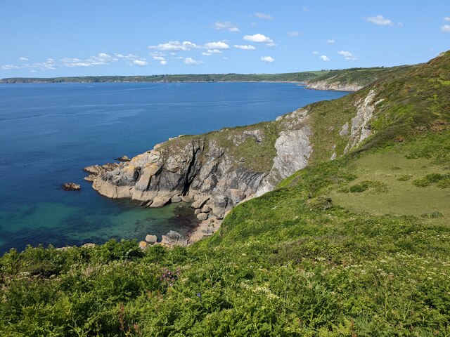
The bay is known for its stunning natural beauty, with rugged cliffs, sandy beaches, and crystal-clear waters. It offers breathtaking views of the surrounding landscape, including rolling hills and quaint fishing villages. The bay is also home to a diverse range of wildlife, including seals, dolphins, and various seabirds.

The beaches in Veryan Bay are particularly popular with visitors, offering a mix of sand and pebbles. Carne Beach and Pendower Beach are two of the most well-known and beloved spots for sunbathing, swimming, and picnicking. These beaches are also great for water sports such as surfing and kayaking.

In addition to its natural attractions, Veryan Bay is steeped in history. The area has a rich maritime heritage, and remnants of old shipwrecks can sometimes be seen along the shoreline. The bay also played a role in the defense of England during World War II, with remnants of military structures still visible today.

Overall, Veryan Bay is a must-visit destination for nature lovers, history enthusiasts, and beachgoers alike. Its stunning scenery, diverse wildlife, and historical significance make it a truly unique and captivating location on the Cornish coast.

If you have any feedback on the listing, please let us know in the comments section below.

Veryan Bay Images

Images are sourced within 2km of 50.230772/-4.8235739 or Grid Reference SW9840. Thanks to Geograph Open Source API. All images are credited.

Cross at Dodman Point
Coast path at the Bulwark The bank is obscured by tall bracken. You get a much better idea from <a href="https://www.geograph.org.uk/photo/4457128">SX0039 : Path junction near the Bulwark on Dodman Point</a>, taken at the same spot. But this image does include Bow (or is it Vault) Beach in the background. The bulwark is the northern earthwork enclosing cliff castle <span class="nowrap"><a title="https://www.historicengland.org.uk/listing/the-list/list-entry/1020865" rel="nofollow ugc noopener" href="https://www.historicengland.org.uk/listing/the-list/list-entry/1020865">Link</a><img style="margin-left:2px;" alt="External link" title="External link - shift click to open in new window" src="https://s1.geograph.org.uk/img/external.png" width="10" height="10"/></span>
Coast path at the Bulwark
The bank is obscured by tall bracken. You get a much better idea from SX0039 : Path junction near the Bulwark on Dodman Point, taken at the same spot. But this image does include Bow (or is it Vault) Beach in the background. The bulwark is the northern earthwork enclosing cliff castle LinkExternal link
Cattle south of Penare From a footpath that follows the bulwark around the Dodman cliff castle to link the coast path northwest and northnortheast of the point.
Cattle south of Penare
From a footpath that follows the bulwark around the Dodman cliff castle to link the coast path northwest and northnortheast of the point.
Trig pillar and Watch House, Dodman Point
Near Dodman Point Looking towards Bow or Vault Beach.
Near Dodman Point
Looking towards Bow or Vault Beach.
View to the coast from the path to Dodman Point
Dodman Trig Point Flush Bracket S1748 and Watch Tower
Gell Point
Gell Point
Dodman Point Beautiful to the eye, this headland has a nasty reputation amongst mariners throughout the ages.
Dodman Point
Beautiful to the eye, this headland has a nasty reputation amongst mariners throughout the ages.
Stone Cross, Dodman Point
Cross at Dodman Point
Dodman Meadow The meadow land on the Dodman promontory covers the site of an ancient hillfort. In the distance are the hills of the St Austell Granite.
Dodman Meadow
The meadow land on the Dodman promontory covers the site of an ancient hillfort. In the distance are the hills of the St Austell Granite.
Dodman from the south west
The cross at Dodman Point
Cross on Dodman Point Approaching this cross on Dodman Point I assumed it was a war memorial, in fact it predates the twentieth century and was erected in 1896 in the hope of the second coming of Jesus Christ.
Cross on Dodman Point
Approaching this cross on Dodman Point I assumed it was a war memorial, in fact it predates the twentieth century and was erected in 1896 in the hope of the second coming of Jesus Christ.
On Dodman Point View to the east from Dodman Point.
On Dodman Point
View to the east from Dodman Point.
Looking along the SWC towards Boswinger
Dodman Cross
Dodman Cross
Show me another place!

Veryan Bay is located at Grid Ref: SW9840 (Lat: 50.230772, Lng: -4.8235739)

Unitary Authority: Cornwall

Police Authority: Devon and Cornwall

What 3 Words

///reshape.giant.vans. Near Mevagissey, Cornwall

Related Wikis

Hemmick Beach

Hemmick Beach is a west-facing beach on the south coast of Cornwall, England. It is situated at the east end of Veryan Bay, on the west side of the Dodman...

Boswinger

Boswinger is a village in south Cornwall, England, two miles south of Mevagissey (where the 2011 Census population is included). There is a youth hostel...

Penare

Penare is a hamlet near Gorran Haven in Cornwall, England, UK. Penare is situated 1 mile (2 km) south-west of Gorran Haven.Pronunciation is PEA - NAR....

St Goran

St Goran is a coastal civil parish in Cornwall, England, UK, six miles (10 km) south-southwest of St Austell. The largest settlement in the parish is the...

Nearby Amenities

Located within 500m of 50.230772,-4.8235739
Source: PGS
Lat/Long: 50.2305386/-4.8301091
Source: PGS
Lat/Long: 50.2304193/-4.8289317
Source: PGS
Lat/Long: 50.2304907/-4.8278776
Source: PGS
Lat/Long: 50.2306228/-4.8266316
Source: PGS
Lat/Long: 50.2309779/-4.8258176
Source: PGS
Lat/Long: 50.23105/-4.8251062
Source: PGS
Lat/Long: 50.2310262/-4.823451
Source: PGS
Lat/Long: 50.2309588/-4.8234631
Source: PGS
Lat/Long: 50.2309057/-4.8233224
Source: PGS
Lat/Long: 50.2311809/-4.8231344
Source: PGS
Lat/Long: 50.2310239/-4.8222069
Source: PGS
Lat/Long: 50.23104/-4.821931
Source: PGS
Lat/Long: 50.231331/-4.8213654
Source: PGS
Lat/Long: 50.2315045/-4.8210159
Source: PGS
Lat/Long: 50.2316621/-4.8190848
Source: PGS
Lat/Long: 50.2312023/-4.8185708
Black Rock
Name Kw: Karrek Dhu
Place: locality
Source: OS_OpenData_StreetView
Lat/Long: 50.2304141/-4.8232974
Cadythew Rock
Place: locality
Source: OS_OpenData_StreetView
Lat/Long: 50.2293778/-4.8174947
Madam Bray
Place: locality
Source: OS_OpenData_StreetView
Lat/Long: 50.2323564/-4.8185676
Percunning
Place: locality
Source: OS_OpenData_StreetView
Lat/Long: 50.2307772/-4.8192854
Clitter's Rock
Place: locality
Source: OS_OpenData_StreetView
Lat/Long: 50.2322672/-4.8215272
Source: PGS
Lat/Long: 50.230829/-4.8183553
Barrier: kissing_gate
Image: https://archive.org/details/porthluney-photos/Porthluney%20to%20Hemmick%20Beach%202020-08-26/DSCN1908.JPG
Lat/Long: 50.2319384/-4.8187937
Barrier: kissing_gate
Lat/Long: 50.2316456/-4.8294823
Barrier: stile
Image: https://archive.org/details/porthluney-photos/Porthluney%20to%20Hemmick%20Beach%202020-08-26/DSCN1910.JPG
Note: The stile is redundant since the fence has been removed and it's possible to bypass it
Step Count: 2
Stile: stepover
Lat/Long: 50.2318706/-4.8186009
Barrier: kissing_gate
Image: https://archive.org/details/porthluney-photos/Porthluney%20to%20Hemmick%20Beach%202020-08-26/DSCN1905.JPG
Lat/Long: 50.2319062/-4.8188969
Barrier: kissing_gate
Image: https://archive.org/details/porthluney-photos/Porthluney%20to%20Hemmick%20Beach%202020-08-26/DSCN1852.JPG
Material: wood
Wheelchair: no
Lat/Long: 50.2314538/-4.8261312
Natural: rock
Lat/Long: 50.2316986/-4.8244357
Natural: rock
Lat/Long: 50.2321378/-4.8213478
Natural: rock
Lat/Long: 50.231778/-4.8236579
The data included in this document is from www.openstreetmap.org. The data is made available under ODbL.

Have you been to Veryan Bay?

Leave your review of Veryan Bay below (or comments, questions and feedback).