Port Ruadh

Bay in Argyllshire

Scotland

Port Ruadh

Plocaid Bo buoy, Gunna Sound
Plocaid Bo buoy, Gunna Sound Credit: Alpin Stewart

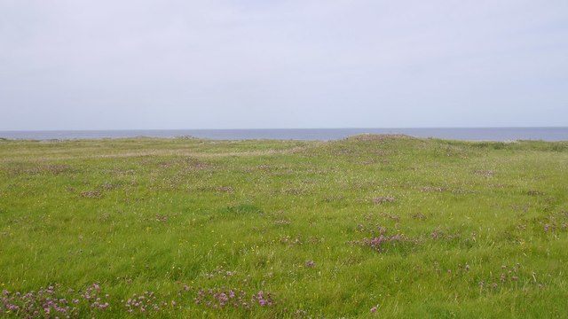
Port Ruadh, also known as Red Bay, is a picturesque coastal village located in Argyllshire, Scotland. Situated on the western coast of the Argyll Peninsula, Port Ruadh offers breathtaking views of the surrounding landscape, making it a popular destination for tourists and nature enthusiasts alike.

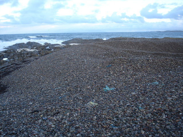
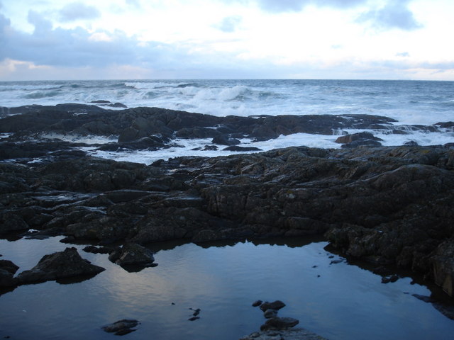
The village is known for its pristine sandy beach, which stretches along the bay and provides a tranquil spot for relaxing walks and sunbathing during the summer months. The crystal-clear waters of the bay also offer opportunities for swimming, snorkeling, and other water activities.

Port Ruadh is home to a small but vibrant community, with charming cottages and houses dotting the shoreline. The village has a rich maritime history, and its small harbor still serves as a base for local fishermen, who can often be seen bringing in their daily catch of fresh seafood.

Nature lovers will appreciate the abundance of wildlife in the area, with seals, dolphins, and even the occasional whale spotted off the coast. The surrounding hills and cliffs provide excellent hiking trails, offering panoramic views of the bay and the nearby islands.

For those interested in history and culture, Port Ruadh is also home to a fascinating archaeological site known as Dun Ruadh. This ancient fort, dating back to the Iron Age, offers a glimpse into the region's rich past.

Overall, Port Ruadh is a charming and idyllic coastal village, offering a perfect blend of natural beauty, outdoor activities, and historical intrigue.

If you have any feedback on the listing, please let us know in the comments section below.

Port Ruadh Images

Images are sourced within 2km of 56.543899/-6.7419914 or Grid Reference NM0849. Thanks to Geograph Open Source API. All images are credited.

Plocaid Bo buoy, Gunna Sound
Port Chunn Nèill, Isle of Tiree
Northeastern corner of Tiree Coastal heath and rock at Urvaig. The basking shark tour boat is off shore with several snorkelling passengers and a couple of basking sharks.  Saw the boat from Coll the previous day but no sharks.
Northeastern corner of Tiree
Coastal heath and rock at Urvaig. The basking shark tour boat is off shore with several snorkelling passengers and a couple of basking sharks. Saw the boat from Coll the previous day but no sharks.
East coast of Tiree View past Gunna, along the coast of Coll towards the Sgùrr of Eigg.
East coast of Tiree
View past Gunna, along the coast of Coll towards the Sgùrr of Eigg.
Machair, Urvaig The northeast tip of Tiree.
Machair, Urvaig
The northeast tip of Tiree.
Urvaig, Tiree Storm beach, looking north from Urvaig, Tiree
Urvaig, Tiree
Storm beach, looking north from Urvaig, Tiree
Watching for sharks off the Sound Of Gunna Looking north from Urvaig, Tiree, across Sound of Gunna towards Isle of Coll
Watching for sharks off the Sound Of Gunna
Looking north from Urvaig, Tiree, across Sound of Gunna towards Isle of Coll
Rocky coast of the most northerly part of Tiree The house in the distance on the 1:25000 is named Urvaig, but then so is the tip of the peninsula.
Rocky coast of the most northerly part of Tiree
The house in the distance on the 1:25000 is named Urvaig, but then so is the tip of the peninsula.
Across the Gunna Sound Unsurprising it is Gunna to be seen across the sound.  Coll can be made out behind Gunna.
Across the Gunna Sound
Unsurprising it is Gunna to be seen across the sound. Coll can be made out behind Gunna.
Foam on the rocks at Urvaig Roughs seas had generated foam which has collected here, much to the amusement of the dog.
Foam on the rocks at Urvaig
Roughs seas had generated foam which has collected here, much to the amusement of the dog.
Pebble beach at Urvaig The dip in the pebbles at the right hand side is where some have been removed and probably crushed and used as aggregate.
Pebble beach at Urvaig
The dip in the pebbles at the right hand side is where some have been removed and probably crushed and used as aggregate.
Rock pool reflection at Urvaig Rough seas contrast with the flat calm on the rock pool.
Rock pool reflection at Urvaig
Rough seas contrast with the flat calm on the rock pool.
Rocks and pebble bank at Urvaig
The beach at Port Chunn Neill The Sound of Gunna and the island of Gunna in the distance.
The beach at Port Chunn Neill
The Sound of Gunna and the island of Gunna in the distance.
West end of Gunna
West end of Gunna
Port Chunn Nèill An eider creche off Tiree.
Port Chunn Nèill
An eider creche off Tiree.
Port Chunn Nèill, Tiree
Coastal grassland at Urvaig
Show me another place!

Port Ruadh is located at Grid Ref: NM0849 (Lat: 56.543899, Lng: -6.7419914)

Unitary Authority: Argyll and Bute

Police Authority: Argyll and West Dunbartonshire

What 3 Words

///tickets.tiles.skewing. Near Scarinish, Argyll & Bute

Related Wikis

Gunna, Scotland

Gunna (Gaelic: Gunnaigh) is an island in the Inner Hebrides of Scotland. == Geography and geology == Gunna lies between Coll and Tiree, closer to Coll...

Dun Mor Vaul

Dun Mor Vaul (or simply Dun Mor; Scottish Gaelic: Dùn Mòr) is an iron-age broch located on the north coast of the island of Tiree, in Scotland. ��2�...

Tiree

Tiree (; Scottish Gaelic: Tiriodh, pronounced [ˈtʲʰiɾʲəɣ]) is the most westerly island in the Inner Hebrides of Scotland. The low-lying island, southwest...

Scarinish

Scarinish (Scottish Gaelic: Sgairinis [ˈs̪kaɾʲɪnɪʃ]) is the main village on the island of Tiree, in the Inner Hebrides of Scotland. It is located on the...

Nearby Amenities

Located within 500m of 56.543899,-6.7419914
Source: PGS
Lat/Long: 56.5481714/-6.7401808
Source: PGS
Lat/Long: 56.5476416/-6.742075
Source: PGS
Lat/Long: 56.5478083/-6.7419853
Source: PGS
Lat/Long: 56.5478125/-6.7418546
Source: PGS
Lat/Long: 56.5477334/-6.7420955
Source: PGS
Lat/Long: 56.5476967/-6.7421699
Source: PGS
Lat/Long: 56.5478139/-6.7419366
Source: PGS
Lat/Long: 56.5476797/-6.7418982
Source: PGS
Lat/Long: 56.5477673/-6.7417623
Source: PGS
Lat/Long: 56.5477193/-6.7417546
Source: PGS
Lat/Long: 56.5476924/-6.7418008
Source: PGS
Lat/Long: 56.5429794/-6.7391416
Telephone
Defibrillator
Access: yes
Booth: K6
Covered: booth
Defibrillator Location: inside old red phone box, Caolas
Emergency: defibrillator
Man Made: telephone_box
Old Phone: +44 1879 220 310
Lat/Long: 56.5413257/-6.7448894
Barrier: cattle_grid
Lat/Long: 56.5415848/-6.7443537
Post Box
Post Box Type: wall
Ref: PA77 121
Royal Cypher: GR
Royal Cypher Wikidata: Q33102273
Lat/Long: 56.5411491/-6.7453954
Barrier: cattle_grid
Lat/Long: 56.5449382/-6.7473305
Barrier: cattle_grid
Lat/Long: 56.5434405/-6.7460684
Power: pole
Lat/Long: 56.5441901/-6.7436233
Power: pole
Lat/Long: 56.542386/-6.7452487
Power: pole
Lat/Long: 56.5421006/-6.746209
Power: pole
Lat/Long: 56.5417856/-6.747365
Power: pole
Lat/Long: 56.5430929/-6.7472953
Power: pole
Lat/Long: 56.5434359/-6.7461446
Power: pole
Lat/Long: 56.5427084/-6.7486149
Power: pole
Lat/Long: 56.5437169/-6.7490897
Power: pole
Lat/Long: 56.5438544/-6.7447364
Caolas
Alt Name Gd: An Caolas Tiristeach
Name Gd: An Caolas
Place: village
Lat/Long: 56.5418078/-6.7439985
Passing Place
Lat/Long: 56.5462922/-6.7485667
Passing Place
Lat/Long: 56.5438681/-6.7464521
Passing Place
Lat/Long: 56.5406111/-6.7472671
Barrier: cattle_grid
Lat/Long: 56.5401784/-6.7394474
Barrier: cattle_grid
Lat/Long: 56.5418577/-6.7431216
Power: pole
Lat/Long: 56.5432644/-6.749323
Power: pole
Lat/Long: 56.5428415/-6.7487866
Power: pole
Lat/Long: 56.5425516/-6.7483735
Power: pole
Lat/Long: 56.5427409/-6.739879
Power: pole
Lat/Long: 56.5427025/-6.74052
Power: pole
Lat/Long: 56.5426404/-6.7414266
Power: pole
Lat/Long: 56.542593/-6.7421642
Power: pole
Lat/Long: 56.5429405/-6.7432612
Power: pole
Lat/Long: 56.5427291/-6.7440203
Power: pole
Lat/Long: 56.5403108/-6.7453438
Power: pole
Lat/Long: 56.541/-6.7462645
Power: pole
Lat/Long: 56.5414599/-6.7469086
Power: pole
Lat/Long: 56.5398544/-6.7390785
Power: pole
Lat/Long: 56.5403713/-6.7392876
The data included in this document is from www.openstreetmap.org. The data is made available under ODbL.

Have you been to Port Ruadh?

Leave your review of Port Ruadh below (or comments, questions and feedback).