Hiort

Island in Inverness-shire

Scotland

Hiort

St Kilda View from Traigh-stir on North Uist at sunset.
St Kilda Credit: Sandy Gerrard

Hiort, also known as St. Kilda, is an archipelago located approximately 64 kilometers west of North Uist in the Outer Hebrides, Scotland. It is part of the Inverness-shire region and is recognized for its outstanding natural beauty and important cultural heritage.

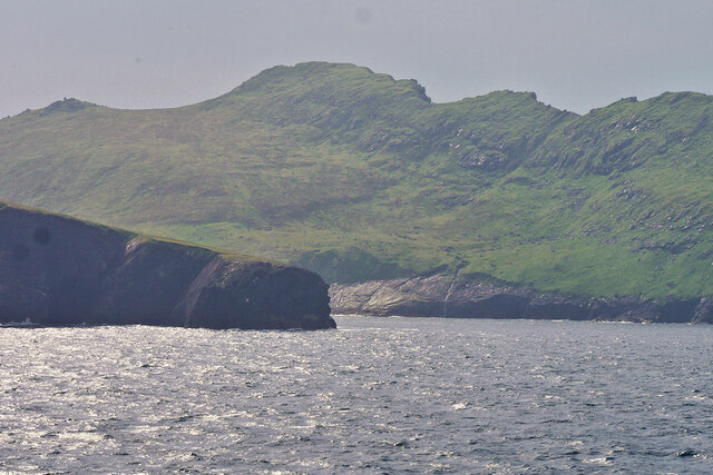
The archipelago consists of four main islands: Hirta, Dun, Soay, and Boreray. Hirta, the largest island, is the only one inhabited by humans, with a population of around 9 people, as of 2021. The other islands are home to various species of seabirds, including puffins, gannets, and fulmars, making it a haven for birdwatchers and nature enthusiasts.

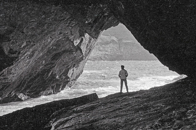
Hiort's remote location and rugged landscape attract adventure seekers and hikers who are eager to explore its dramatic cliffs, sea stacks, and breathtaking sea views. The highest point on the archipelago is Conachair, standing at 430 meters above sea level, offering panoramic vistas of the surrounding islands and the Atlantic Ocean.

The archipelago's cultural significance lies in its history as a remote Gaelic-speaking community that existed for thousands of years. Hiort played a pivotal role in the development of the island's unique traditions, agricultural practices, and social structures. In 1930, the remaining islanders were evacuated due to the harsh living conditions, and Hiort was abandoned. Today, it is a UNESCO World Heritage Site, preserving the cultural heritage and providing a glimpse into the island's history.

Visitors to Hiort can experience the island's rich history through guided tours, exploring the abandoned village, and learning about the challenges faced by its former inhabitants. The archipelago is accessible by boat from the mainland, and a visit to Hiort offers a truly unique and unforgettable experience in the remote wilderness of Inverness-shire.

If you have any feedback on the listing, please let us know in the comments section below.

Hiort Images

Images are sourced within 2km of 57.814359/-8.5813168 or Grid Reference NF0999. Thanks to Geograph Open Source API. All images are credited.

St Kilda View from Traigh-stir on North Uist at sunset.
St Kilda
View from Traigh-stir on North Uist at sunset.
Geodha na h-Àirde (The Tunnel),  St Kilda A long tunnel cuts through the headland of Gob na h-Àirde which is marked on OS maps as an arch. This is the view at the Gleann Mòr entrance looking towards the bay.  Access is by a sloping ledge visible in <a href="https://www.geograph.org.uk/photo/1291360">NA0800 : Gob na h-Airde</a>.  The floor of the tunnel has the name Leacan an t-Sluic Mhóir that means The flagstones of the big hole.  Jim Crumley in his book, Among Islands, published in 1994, commented that The Tunnel is a landscape out of the top drawer and that "The Trumpet-blowers played the thing down, for memory in such a landscape is not to be trusted".  This is the first image inside the Tunnel on Geograph.
Geodha na h-Àirde (The Tunnel), St Kilda
A long tunnel cuts through the headland of Gob na h-Àirde which is marked on OS maps as an arch. This is the view at the Gleann Mòr entrance looking towards the bay. Access is by a sloping ledge visible in NA0800 : Gob na h-Airde. The floor of the tunnel has the name Leacan an t-Sluic Mhóir that means The flagstones of the big hole. Jim Crumley in his book, Among Islands, published in 1994, commented that The Tunnel is a landscape out of the top drawer and that "The Trumpet-blowers played the thing down, for memory in such a landscape is not to be trusted". This is the first image inside the Tunnel on Geograph.
The Amazon's House, Gleann Mor, St Kilda One of the many structures in Gleann Mor, St Kilda, but this one is the most studied and is named on OS Maps. In Gleann Mor, complex clusters of remains bear affinities with the building traditions of Iron Age wheelhouses, of particular note being the Amazon's House, with its central chamber and linked cells beneath turfed corbelling. <span class="nowrap"><a title="https://canmore.org.uk/site/3960/st-kilda-hirta-gleann-mor-the-amazons-house" rel="nofollow ugc noopener" href="https://canmore.org.uk/site/3960/st-kilda-hirta-gleann-mor-the-amazons-house">Link</a><img style="margin-left:2px;" alt="External link" title="External link - shift click to open in new window" src="https://s1.geograph.org.uk/img/external.png" width="10" height="10"/></span>
The Amazon's House, Gleann Mor, St Kilda
One of the many structures in Gleann Mor, St Kilda, but this one is the most studied and is named on OS Maps. In Gleann Mor, complex clusters of remains bear affinities with the building traditions of Iron Age wheelhouses, of particular note being the Amazon's House, with its central chamber and linked cells beneath turfed corbelling. LinkExternal link
Dùn from Ruabhal A classic view of Dùn.  I had a memorable day on Dùn not helped by falling into the sea when being landed.  It is lucky my camera survived to take these images later.
Dùn from Ruabhal
A classic view of Dùn. I had a memorable day on Dùn not helped by falling into the sea when being landed. It is lucky my camera survived to take these images later.
Cleit on the side of Mullach Mòr This spot provides a good view into Gleann Mòr towards The Cambir (An Campar).
Cleit on the side of Mullach Mòr
This spot provides a good view into Gleann Mòr towards The Cambir (An Campar).
Village Bay from the side of Ruabhal, Hirta The military encampment is noticeable and this image was taken when the North Uist Rocket Range was extensively used by NATO.
Village Bay from the side of Ruabhal, Hirta
The military encampment is noticeable and this image was taken when the North Uist Rocket Range was extensively used by NATO.
Below The Mistress Stone, St Kilda This stone shared with The Lovers Stone a role in proving fidelity in courtship. Village Bay, Hirta is in the background.
Below The Mistress Stone, St Kilda
This stone shared with The Lovers Stone a role in proving fidelity in courtship. Village Bay, Hirta is in the background.
Mina Stac and the cliffs to its south, Hirta
Radar Tracking Station on Mullach Sgar This radar station, located on Mullach Sgar, is one of two stations on the island which serve the South Uist rocket range. They contain equipment which allows them to track test firings on the range by radar, and to record images of missiles in flight. The second radar station on Hirta is located further north, on the summit of Mullach Mòr.
Radar Tracking Station on Mullach Sgar
This radar station, located on Mullach Sgar, is one of two stations on the island which serve the South Uist rocket range. They contain equipment which allows them to track test firings on the range by radar, and to record images of missiles in flight. The second radar station on Hirta is located further north, on the summit of Mullach Mòr.
Hirta, Mina Stac and the cliffs to its south
Former Quarry Site on Hirta
Dùn and Hirta A view along the coast of Dùn towards Ruabhal, on the island of Hirta, and the narrow strait (Caolas an Dùin) which separates the two islands. View taken from Bhàga a’ Bhaile (Village Bay).
Dùn and Hirta
A view along the coast of Dùn towards Ruabhal, on the island of Hirta, and the narrow strait (Caolas an Dùin) which separates the two islands. View taken from Bhàga a’ Bhaile (Village Bay).
Mina Stac, Hirta Hirta is surrounded by a number of small stacks. Mina Stac rises spectacularly to a height of approximately 70 metres, separated by only a few feet from the spectacular cliffs (the highest sea cliffs in the UK) which descend from the summit Conachair.
Mina Stac, Hirta
Hirta is surrounded by a number of small stacks. Mina Stac rises spectacularly to a height of approximately 70 metres, separated by only a few feet from the spectacular cliffs (the highest sea cliffs in the UK) which descend from the summit Conachair.
St Kilda, Mina Stac Hirta is surrounded by a number of small stacks. Mina Stac rises spectacularly to a height of approximately 70 metres, separated by only a few feet from the spectacular cliffs (the highest sea cliffs in the UK) which descend from the summit of Conachair, the highest point on the island.
St Kilda, Mina Stac
Hirta is surrounded by a number of small stacks. Mina Stac rises spectacularly to a height of approximately 70 metres, separated by only a few feet from the spectacular cliffs (the highest sea cliffs in the UK) which descend from the summit of Conachair, the highest point on the island.
Hirta, Gob na h-Àirde A small headland which forms the eastern side of Glen Bay on the north coast of Hirta, the principal island of the St Kilda archipelago.
Hirta, Gob na h-Àirde
A small headland which forms the eastern side of Glen Bay on the north coast of Hirta, the principal island of the St Kilda archipelago.
Radar Tracking Station on Mullach Mor This radar station is located on the summit of Mullach Mor. It is one of two radar stations on the island which serve the South Uist rocket range. They contain equipment which allows them to track test firings on the range by radar, and to record images of missiles in flight. The second radar station on Hirta is located further south, on Mullach Sgar (<a href="https://www.geograph.org.uk/photo/7366677">NF0998 : Radar Tracking Station on Mullach Sgar</a>).
Radar Tracking Station on Mullach Mor
This radar station is located on the summit of Mullach Mor. It is one of two radar stations on the island which serve the South Uist rocket range. They contain equipment which allows them to track test firings on the range by radar, and to record images of missiles in flight. The second radar station on Hirta is located further south, on Mullach Sgar (NF0998 : Radar Tracking Station on Mullach Sgar).
Abhainn Mhòr, Hirta Flowing past the western end of the old village.
Abhainn Mhòr, Hirta
Flowing past the western end of the old village.
Abhainn Mhòr With some of the maintained cleits along the banks.
Abhainn Mhòr
With some of the maintained cleits along the banks.
Show me another place!

Hiort is located at Grid Ref: NF0999 (Lat: 57.814359, Lng: -8.5813168)

Unitary Authority: Na h-Eileanan an Iar

Police Authority: Highlands and Islands

Also known as: Hirta

What 3 Words

///stand.angel.unwraps. Near Balivanich, Na h-Eileanan Siar

Related Wikis

St Kilda, Scotland

St Kilda (Scottish Gaelic: Hiort) is an isolated archipelago situated 64 kilometres (40 mi) west-northwest of North Uist in the North Atlantic Ocean. It...

Hirta

Hirta (Scottish Gaelic: Hiort) is the largest island in the St Kilda archipelago, on the western edge of Scotland. The names Hiort (in Scottish Gaelic...

Dùn

Dùn is an island in St Kilda, Scotland. It is nearly 1 mile (1.6 kilometres) long. Its name simply means "fort" in Scottish Gaelic (for more information...

Stac Biorach

Stac Biorach (Scottish Gaelic: "the pointed stack") is a sea stack, 73 metres tall, situated between Hirta and Soay (in the "Sound of Soay") in the St...

Nearby Amenities

Located within 500m of 57.814359,-8.5813168
Lag Altimir
Place: locality
Lat/Long: 57.8151038/-8.5748964
Mullach Geal
Place: locality
Lat/Long: 57.814458/-8.5852068
Gearraidh Àrd
Place: locality
Lat/Long: 57.8115319/-8.5770636
The data included in this document is from www.openstreetmap.org. The data is made available under ODbL.

Have you been to Hiort?

Leave your review of Hiort below (or comments, questions and feedback).