Eilean a' Chrotha

Island in Argyllshire

Scotland

Eilean a' Chrotha

Triangulation pillar, Àird Mòr, Ross of Mull, Isle of Mull Looking towards Eilean na Seamair to the left and the Ross of Mull and Erraid to the right.
Triangulation pillar, Àird Mòr, Ross of Mull, Isle of Mull Credit: Claire Pegrum

Eilean a' Chrotha, also known as the Isle of Crouches, is a small uninhabited island located in Argyllshire, Scotland. It is situated in Loch Linnhe, an inlet of the Atlantic Ocean, near the western coast of the country. The island covers an area of approximately 7 acres and is characterized by its rocky terrain and lush vegetation.

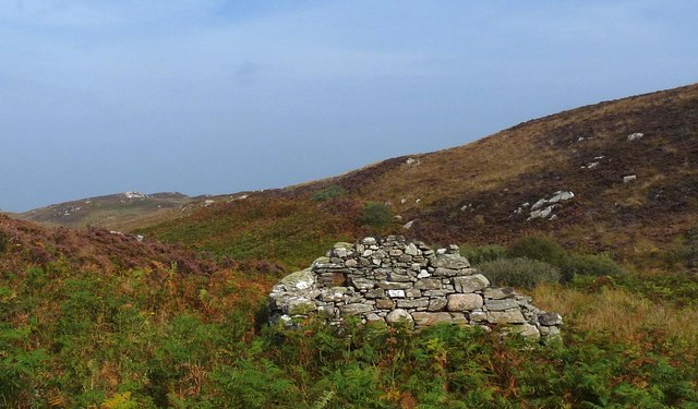
Eilean a' Chrotha is part of a group of islands known as the Garvellachs, which also includes Eileach an Naoimh and two smaller islets. These islands are of historical and archaeological significance, with evidence of early Christian settlements dating back to the 6th century. There are remains of ancient chapels, monastic cells, and burial grounds on Eilean a' Chrotha, providing a glimpse into the island's religious past.

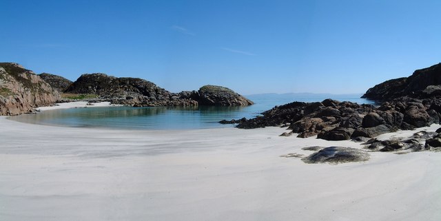
The island is uninhabited and lacks any modern amenities or infrastructure. It is primarily visited by tourists and history enthusiasts who are interested in exploring its ancient ruins and experiencing its natural beauty. Eilean a' Chrotha offers breathtaking views of the surrounding sea and the dramatic Scottish landscape.

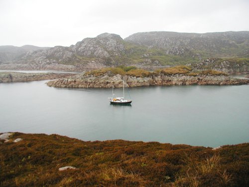
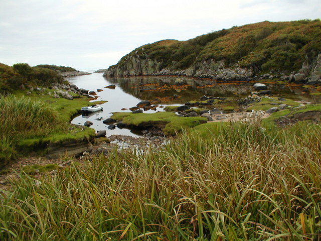
Access to the island is limited, and visitors often arrive by boat, either privately or through organized tours. It is important to note that due to its protected status, visitors are advised to respect the island's natural environment and historical remains, ensuring they leave no trace behind.

In summary, Eilean a' Chrotha is a small, uninhabited island in Argyllshire, Scotland, known for its ancient Christian ruins and stunning natural scenery. It offers a unique opportunity to explore Scotland's history and connect with its rugged coastal landscape.

If you have any feedback on the listing, please let us know in the comments section below.

Eilean a' Chrotha Images

Images are sourced within 2km of 56.270838/-6.2980519 or Grid Reference NM3417. Thanks to Geograph Open Source API. All images are credited.

Triangulation pillar, Àird Mòr, Ross of Mull, Isle of Mull Looking towards Eilean na Seamair to the left and the Ross of Mull and Erraid to the right.
Triangulation pillar, Àird Mòr, Ross of Mull, Isle of Mull
Looking towards Eilean na Seamair to the left and the Ross of Mull and Erraid to the right.
Ruined building by the Allt na Tràighe Gile, Isle of Mull The RCAHMS record for this building ( <span class="nowrap"><a title="http://canmore.rcahms.gov.uk/en/site/86733/details/mull+breac+achadh/" rel="nofollow ugc noopener" href="http://canmore.rcahms.gov.uk/en/site/86733/details/mull+breac+achadh/">Link</a><img style="margin-left:2px;" alt="External link" title="External link - shift click to open in new window" src="https://s1.geograph.org.uk/img/external.png" width="10" height="10"/></span> ) describes it as a cruck framed cottage.  However, there is also a suggestion that it might have been a mill (page 5, <span class="nowrap"><a title="http://www.highlandrenewal.org/assets/files/Tireragan_History.pdf" rel="nofollow ugc noopener" href="http://www.highlandrenewal.org/assets/files/Tireragan_History.pdf">Link</a><img style="margin-left:2px;" alt="External link" title="External link - shift click to open in new window" src="https://s1.geograph.org.uk/img/external.png" width="10" height="10"/></span> ).
Ruined building by the Allt na Tràighe Gile, Isle of Mull
The RCAHMS record for this building ( LinkExternal link ) describes it as a cruck framed cottage. However, there is also a suggestion that it might have been a mill (page 5, LinkExternal link ).
Lochan below Àird Mòr, Isle of Mull The lochan lies on a burn that flows down to the beach at Port na Luing on the western coast of the Ross of Mull.
Lochan below Àird Mòr, Isle of Mull
The lochan lies on a burn that flows down to the beach at Port na Luing on the western coast of the Ross of Mull.
Ruined building, An Cholarich, Isle of Mull The 1st edition OS six map, which was surveyed in 1878, shows an unroofed building here and also a nearby field wall, which can still be identified on the ground.
Ruined building, An Cholarich, Isle of Mull
The 1st edition OS six map, which was surveyed in 1878, shows an unroofed building here and also a nearby field wall, which can still be identified on the ground.
View towards Eilean Mòr, Isle of Mull
Breac-achadh The settlement at Breac-achadh was deserted during the nineteenth century as a result of the Highland Clearances. Sheep farming was more profitable to the landlords than small collections of subsistence farmers ekeing a living on marginal land.
Breac-achadh
The settlement at Breac-achadh was deserted during the nineteenth century as a result of the Highland Clearances. Sheep farming was more profitable to the landlords than small collections of subsistence farmers ekeing a living on marginal land.
Traigh Gheal The path to the beach leads down through birch and scrub willow woodland.
Traigh Gheal
The path to the beach leads down through birch and scrub willow woodland.
Traigh Gheal A view taken at the eastern end of this beautiful, remote beach.
Traigh Gheal
A view taken at the eastern end of this beautiful, remote beach.
The anchorage at  Rubh  Ardalanish A wild, remote spot on the Ross of Mull. The rock here is all granite but nearby there is metamorphic rock where garnets can be found on the beach. A lonely place now but there is much of evidence of former habitation around the bay.
The anchorage at Rubh Ardalanish
A wild, remote spot on the Ross of Mull. The rock here is all granite but nearby there is metamorphic rock where garnets can be found on the beach. A lonely place now but there is much of evidence of former habitation around the bay.
Creek north of Rubh Ardalanish Coastal land between Torr na Sealga and Beinn a Chaol-airigh to the north of the anchorage on Rubh Ardalanish
Creek north of Rubh Ardalanish
Coastal land between Torr na Sealga and Beinn a Chaol-airigh to the north of the anchorage on Rubh Ardalanish
Slight detour required to navigate past boggy pond. Small pond fed by stream uphill to the left
Slight detour required to navigate past boggy pond.
Small pond fed by stream uphill to the left
Impressively weathered steps In the back-ground remnants of buildings, part of the Breac achadh settlement?
Impressively weathered steps
In the back-ground remnants of buildings, part of the Breac achadh settlement?
View of the four abandoned houses.
Tràigh Gheal Following in the footsteps of David Balfour, the hero of Robert Louis Stevenson's Kidnapped, as he makes his way back to Edinburgh to confront his wicked uncle.

Stage 1, June 2016 from Erraid to Fishnish on the Isle of Mull.

See <span class="nowrap"><a title="http://www.stevensonway.org.uk" rel="nofollow ugc noopener" href="http://www.stevensonway.org.uk">Link</a><img style="margin-left:2px;" alt="External link" title="External link - shift click to open in new window" src="https://s1.geograph.org.uk/img/external.png" width="10" height="10"/></span>
Tràigh Gheal
Following in the footsteps of David Balfour, the hero of Robert Louis Stevenson's Kidnapped, as he makes his way back to Edinburgh to confront his wicked uncle. Stage 1, June 2016 from Erraid to Fishnish on the Isle of Mull. See LinkExternal link
Tràigh Gheal The climb out of Tràigh Gheal. Not too bad so far but soon fighting through bracken, bog myrtle and sage scrub.
Tràigh Gheal
The climb out of Tràigh Gheal. Not too bad so far but soon fighting through bracken, bog myrtle and sage scrub.
Tràigh Gheal Following in the footsteps of David Balfour, the hero of Robert Louis Stevenson's Kidnapped, as he makes his way back to Edinburgh to confront his wicked uncle.

Stage 1, June 2016 from Erraid to Fishnish on the Isle of Mull.

See <span class="nowrap"><a title="http://www.stevensonway.org.uk" rel="nofollow ugc noopener" href="http://www.stevensonway.org.uk">Link</a><img style="margin-left:2px;" alt="External link" title="External link - shift click to open in new window" src="https://s1.geograph.org.uk/img/external.png" width="10" height="10"/></span>
Tràigh Gheal
Following in the footsteps of David Balfour, the hero of Robert Louis Stevenson's Kidnapped, as he makes his way back to Edinburgh to confront his wicked uncle. Stage 1, June 2016 from Erraid to Fishnish on the Isle of Mull. See LinkExternal link
Tireragan Tireragan is a deserted village dating to the 18th and 19th centuries. At its peak there would have been approximately 100 people living here. Nearby is a separate settlement Breac-achadh. on the Ordnance Survey map the village is named as Tir Fhearagain.

The folk of Tireragan would have been subsistence farmers supplementing their income from the burning of kelp and selling the ash for gun powder production. But during the early 19th century other methods of producing gunpowder were developed, the potato blight caused widespread famine and sheep farming proved more profitable for the landowners resulting in the population being evicted. By 1861 there were no one living at Tireragan.

For more details of Tireragan and Breac-achadh see <span class="nowrap"><a title="https://canmore.org.uk/site/21746/mull-tir-fhearagain" rel="nofollow ugc noopener" href="https://canmore.org.uk/site/21746/mull-tir-fhearagain">Link</a><img style="margin-left:2px;" alt="External link" title="External link - shift click to open in new window" src="https://s1.geograph.org.uk/img/external.png" width="10" height="10"/></span> and <span class="nowrap"><a title="https://canmore.org.uk/site/21745/mull-breac-achadh" rel="nofollow ugc noopener" href="https://canmore.org.uk/site/21745/mull-breac-achadh">Link</a><img style="margin-left:2px;" alt="External link" title="External link - shift click to open in new window" src="https://s1.geograph.org.uk/img/external.png" width="10" height="10"/></span>
Tireragan
Tireragan is a deserted village dating to the 18th and 19th centuries. At its peak there would have been approximately 100 people living here. Nearby is a separate settlement Breac-achadh. on the Ordnance Survey map the village is named as Tir Fhearagain. The folk of Tireragan would have been subsistence farmers supplementing their income from the burning of kelp and selling the ash for gun powder production. But during the early 19th century other methods of producing gunpowder were developed, the potato blight caused widespread famine and sheep farming proved more profitable for the landowners resulting in the population being evicted. By 1861 there were no one living at Tireragan. For more details of Tireragan and Breac-achadh see LinkExternal link and LinkExternal link
Show me another place!

Eilean a' Chrotha is located at Grid Ref: NM3417 (Lat: 56.270838, Lng: -6.2980519)

Unitary Authority: Argyll and Bute

Police Authority: Argyll and West Dunbartonshire

What 3 Words

///weaned.harmony.appoints. Near Fionnphort, Argyll & Bute

Related Wikis

Ardalanish

Ardalanish (Scottish Gaelic: Àird Dealanais) is a village on the Isle of Mull in Argyll and Bute, Scotland. It is now an organic farm and weaving mill...

Knocknafenaig

Knocknafenaig (Scottish Gaelic: Cnoc na Fennaig) is a ruined township on the Isle of Mull, Scotland. Located in the south-western portion of the island...

Ross of Mull

The Ross of Mull (Scottish Gaelic: An Ros Mhuileach) is the largest peninsula of the Isle of Mull, about 28 kilometres (17 mi) long, and makes up the south...

Erraid

Erraid (Scottish Gaelic: Eilean Earraid) is a tidal island approximately one mile (two kilometres) square located in the Inner Hebrides of Scotland. It...

Nearby Amenities

Located within 500m of 56.270838,-6.2980519
Source: PGS
Lat/Long: 56.2707212/-6.2973263
Created By: dmgroom_coastlines
Source: PGS
Lat/Long: 56.27085/-6.29724
Created By: dmgroom_coastlines
Source: PGS
Lat/Long: 56.27096/-6.29754
Created By: dmgroom_coastlines
Source: PGS
Lat/Long: 56.27069/-6.29756
Created By: dmgroom_coastlines
Source: PGS
Lat/Long: 56.27057/-6.29802
Created By: dmgroom_coastlines
Source: PGS
Lat/Long: 56.27058/-6.29848
Created By: dmgroom_coastlines
Source: PGS
Lat/Long: 56.27072/-6.29871
Created By: dmgroom_coastlines
Source: PGS
Lat/Long: 56.27098/-6.29892
Created By: dmgroom_coastlines
Source: PGS
Lat/Long: 56.27109/-6.29845
Source: PGS
Lat/Long: 56.2713759/-6.2979217
Source: PGS
Lat/Long: 56.2710703/-6.2974378
Source: PGS
Lat/Long: 56.2710059/-6.2970709
Source: PGS
Lat/Long: 56.2709064/-6.2970055
Created By: dmgroom_coastlines
Source: PGS
Lat/Long: 56.26734/-6.3024
Source: PGS
Lat/Long: 56.2675648/-6.3022873
Source: PGS
Lat/Long: 56.2677066/-6.3021746
Created By: dmgroom_coastlines
Source: PGS
Lat/Long: 56.26771/-6.30191
Created By: dmgroom_coastlines
Source: PGS
Lat/Long: 56.2672/-6.30195
Source: PGS
Lat/Long: 56.2673462/-6.2956429
Created By: dmgroom_coastlines
Source: PGS
Lat/Long: 56.26784/-6.29592
Created By: dmgroom_coastlines
Source: PGS
Lat/Long: 56.26786/-6.29684
Created By: dmgroom_coastlines
Source: PGS
Lat/Long: 56.26812/-6.29682
Created By: dmgroom_coastlines
Source: PGS
Lat/Long: 56.2681/-6.2959
Created By: dmgroom_coastlines
Source: PGS
Lat/Long: 56.26861/-6.29609
Created By: dmgroom_coastlines
Source: PGS
Lat/Long: 56.26913/-6.29629
Created By: dmgroom_coastlines
Source: PGS
Lat/Long: 56.26911/-6.29537
Created By: dmgroom_coastlines
Source: PGS
Lat/Long: 56.26987/-6.29508
Created By: dmgroom_coastlines
Source: PGS
Lat/Long: 56.27038/-6.29482
Source: PGS
Lat/Long: 56.2705758/-6.2950507
Created By: dmgroom_coastlines
Source: PGS
Lat/Long: 56.27064/-6.29526
Created By: dmgroom_coastlines
Source: PGS
Lat/Long: 56.27076/-6.29479
Created By: dmgroom_coastlines
Source: PGS
Lat/Long: 56.27075/-6.29433
Created By: dmgroom_coastlines
Source: PGS
Lat/Long: 56.27059/-6.29296
Created By: dmgroom_coastlines
Source: PGS
Lat/Long: 56.27033/-6.29275
Created By: dmgroom_coastlines
Source: PGS
Lat/Long: 56.27007/-6.29231
Created By: dmgroom_coastlines
Source: PGS
Lat/Long: 56.26954/-6.29188
Created By: dmgroom_coastlines
Source: PGS
Lat/Long: 56.26928/-6.29144
Created By: dmgroom_coastlines
Source: PGS
Lat/Long: 56.26876/-6.29148
Created By: dmgroom_coastlines
Source: PGS
Lat/Long: 56.26851/-6.2915
Created By: dmgroom_coastlines
Source: PGS
Lat/Long: 56.26727/-6.29319
Created By: dmgroom_coastlines
Source: PGS
Lat/Long: 56.26691/-6.2946
Created By: dmgroom_coastlines
Source: PGS
Lat/Long: 56.26705/-6.29505
Source: PGS
Lat/Long: 56.2668957/-6.2956858
Created By: dmgroom_coastlines
Source: PGS
Lat/Long: 56.27067/-6.29066
Created By: dmgroom_coastlines
Source: PGS
Lat/Long: 56.27068/-6.29111
Created By: dmgroom_coastlines
Source: PGS
Lat/Long: 56.2707/-6.29203
Created By: dmgroom_coastlines
Source: PGS
Lat/Long: 56.27083/-6.29226
Created By: dmgroom_coastlines
Source: PGS
Lat/Long: 56.27109/-6.29246
Created By: dmgroom_coastlines
Source: PGS
Lat/Long: 56.27107/-6.29154
Source: PGS
Lat/Long: 56.2713943/-6.2911282
Created By: dmgroom_coastlines
Source: PGS
Lat/Long: 56.27147/-6.29198
Created By: dmgroom_coastlines
Source: PGS
Lat/Long: 56.27179/-6.29518
Created By: dmgroom_coastlines
Source: PGS
Lat/Long: 56.27193/-6.2954
Created By: dmgroom_coastlines
Source: PGS
Lat/Long: 56.27206/-6.29562
Created By: dmgroom_coastlines
Source: PGS
Lat/Long: 56.27219/-6.29584
Created By: dmgroom_coastlines
Source: PGS
Lat/Long: 56.27232/-6.29606
Source: PGS
Lat/Long: 56.2726066/-6.2960892
Created By: dmgroom_coastlines
Source: PGS
Lat/Long: 56.27297/-6.29647
Source: PGS
Lat/Long: 56.2718936/-6.2952985
Source: PGS
Lat/Long: 56.2715296/-6.2958886
Source: PGS
Lat/Long: 56.2718042/-6.2968714
Source: PGS
Lat/Long: 56.2721003/-6.2976707
Source: PGS
Lat/Long: 56.2724976/-6.2986856
Source: PGS
Lat/Long: 56.2721902/-6.3001308
Source: PGS
Lat/Long: 56.2730062/-6.3001193
Created By: dmgroom_coastlines
Source: PGS
Lat/Long: 56.2728/-6.3004
Created By: dmgroom_coastlines
Source: PGS
Lat/Long: 56.27255/-6.30042
Created By: dmgroom_coastlines
Source: PGS
Lat/Long: 56.27204/-6.30045
Created By: dmgroom_coastlines
Source: PGS
Lat/Long: 56.27153/-6.30072
Created By: dmgroom_coastlines
Source: PGS
Lat/Long: 56.27151/-6.2998
Created By: dmgroom_coastlines
Source: PGS
Lat/Long: 56.271/-6.30007
Created By: dmgroom_coastlines
Source: PGS
Lat/Long: 56.27025/-6.30058
Created By: dmgroom_coastlines
Source: PGS
Lat/Long: 56.26975/-6.30108
Created By: dmgroom_coastlines
Source: PGS
Lat/Long: 56.26962/-6.30131
Source: PGS
Lat/Long: 56.2693259/-6.3017423
Created By: dmgroom_coastlines
Source: PGS
Lat/Long: 56.26824/-6.30256
Created By: dmgroom_coastlines
Source: PGS
Lat/Long: 56.26812/-6.3028
Created By: dmgroom_coastlines
Source: PGS
Lat/Long: 56.26799/-6.30304
Created By: dmgroom_coastlines
Source: PGS
Lat/Long: 56.26787/-6.30328
Created By: dmgroom_coastlines
Source: PGS
Lat/Long: 56.26776/-6.30352
The data included in this document is from www.openstreetmap.org. The data is made available under ODbL.

Have you been to Eilean a' Chrotha?

Leave your review of Eilean a' Chrotha below (or comments, questions and feedback).