Frostenden Bottom

Valley in Suffolk East Suffolk

England

Frostenden Bottom

Field south-east of Wrentham
Field south-east of Wrentham Credit: Christopher Hilton

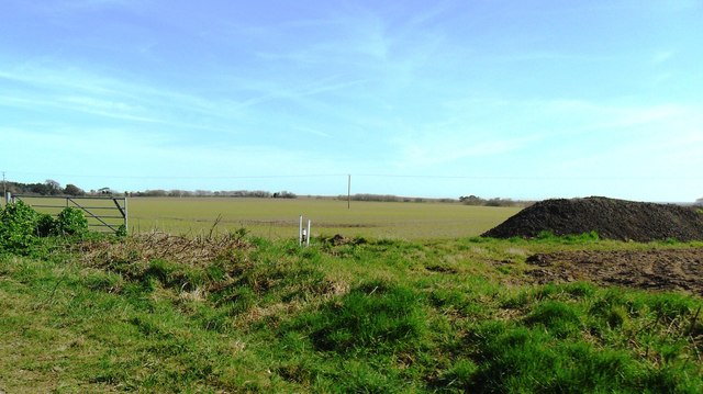
Frostenden Bottom, Suffolk is a picturesque valley located in the county of Suffolk, England. Nestled amidst the rolling green hills of the Suffolk countryside, this tranquil valley offers a captivating natural beauty that attracts visitors from near and far.

The valley is characterized by its lush meadows, ancient woodlands, and sparkling streams, creating a haven for wildlife and nature enthusiasts. It is home to a diverse range of plant and animal species, including rare butterflies, birds, and wildflowers, making it an ideal spot for nature lovers and photographers.

Frostenden Bottom is also known for its idyllic walking and hiking trails, which meander through the valley, offering breathtaking views of the surrounding landscape. These trails provide visitors with an opportunity to explore the area's natural wonders, including babbling brooks, hidden waterfalls, and charming footbridges.

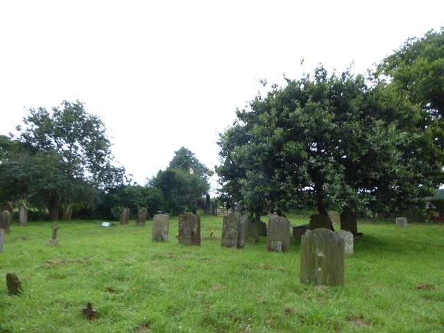
In addition to its natural beauty, Frostenden Bottom boasts a rich history. The valley has been inhabited since ancient times, with evidence of human activity dating back to the Neolithic period. Visitors can still find remnants of ancient settlements, burial mounds, and historical landmarks, adding an intriguing historical dimension to the valley's allure.

Despite its peaceful and secluded atmosphere, Frostenden Bottom is easily accessible, with nearby parking facilities and public transportation options. Whether it's a leisurely walk, a picnic amidst the wildflowers, or an exploration of the valley's historical sites, Frostenden Bottom offers a truly enchanting experience for all who visit.

If you have any feedback on the listing, please let us know in the comments section below.

Frostenden Bottom Images

Images are sourced within 2km of 52.373101/1.6570309 or Grid Reference TM4981. Thanks to Geograph Open Source API. All images are credited.

Field south-east of Wrentham
Fields and fertiliser near Covehithe, Suffolk
Church of All Saints, Frostenden <span class="nowrap"><a title="https://historicengland.org.uk/listing/the-list/list-entry/1032170?section=official-list-entry" rel="nofollow ugc noopener" href="https://historicengland.org.uk/listing/the-list/list-entry/1032170?section=official-list-entry">Link</a><img style="margin-left:2px;" alt="External link" title="External link - shift click to open in new window" src="https://s1.geograph.org.uk/img/external.png" width="10" height="10"/></span>
Church of All Saints, Frostenden
Goughs, Frostenden <span class="nowrap"><a title="https://historicengland.org.uk/listing/the-list/list-entry/1352547?section=official-list-entry" rel="nofollow ugc noopener" href="https://historicengland.org.uk/listing/the-list/list-entry/1352547?section=official-list-entry">Link</a><img style="margin-left:2px;" alt="External link" title="External link - shift click to open in new window" src="https://s1.geograph.org.uk/img/external.png" width="10" height="10"/></span>
Goughs, Frostenden
Waiting for Life to Emerge Large field near Frostenden Hall.
Waiting for Life to Emerge
Large field near Frostenden Hall.
Church of St. Nicholas, Wrentham <span class="nowrap"><a title="https://historicengland.org.uk/listing/the-list/list-entry/1284532?section=official-list-entry" rel="nofollow ugc noopener" href="https://historicengland.org.uk/listing/the-list/list-entry/1284532?section=official-list-entry">Link</a><img style="margin-left:2px;" alt="External link" title="External link - shift click to open in new window" src="https://s1.geograph.org.uk/img/external.png" width="10" height="10"/></span>
Church of St. Nicholas, Wrentham
Wrentham War Memorial <span class="nowrap"><a title="https://historicengland.org.uk/listing/the-list/list-entry/1458655?section=official-list-entry" rel="nofollow ugc noopener" href="https://historicengland.org.uk/listing/the-list/list-entry/1458655?section=official-list-entry">Link</a><img style="margin-left:2px;" alt="External link" title="External link - shift click to open in new window" src="https://s1.geograph.org.uk/img/external.png" width="10" height="10"/></span>
Wrentham War Memorial
Gate And Field Metal gate and field near to South Cove, Suffolk.
Gate And Field
Metal gate and field near to South Cove, Suffolk.
Minor Road Minor road looking west near to South Cove, Suffolk.
Minor Road
Minor road looking west near to South Cove, Suffolk.
Road Junction Road junction on Mill Lane near to Wrentham, Suffolk.
Road Junction
Road junction on Mill Lane near to Wrentham, Suffolk.
Field Boundary Field boundary near to South Cove, Suffolk.
Field Boundary
Field boundary near to South Cove, Suffolk.
St Lawrence, South Cove: churchyard
St Lawrence, South Cove: porch
St Lawrence, South Cove: churchyard (iv)
St Lawrence, South Cove: churchyard (v)
St Lawrence, South Cove: churchyard (vi)
St Lawrence, South Cove: flower festival exhibits (i)
St Lawrence, South Cove: flower festival exhibits (ii)
Show me another place!

Frostenden Bottom is located at Grid Ref: TM4981 (Lat: 52.373101, Lng: 1.6570309)

Administrative County: Suffolk

District: East Suffolk

Police Authority: Suffolk

What 3 Words

///commands.insisting.fillers. Near Southwold, Suffolk

Related Wikis

Frostenden

Frostenden is a village and civil parish in the East Suffolk district of the English county of Suffolk. It is around 8 miles (13 km) south-west of Lowestoft...

South Cove, Suffolk

South Cove is a civil parish in the east of the English county of Suffolk. It is 3 miles (4.8 km) north of the coastal town of Southwold and 1 mile (1...

Wrentham, Suffolk

Wrentham is a village and civil parish in the East Suffolk district, in the north-east of the English county of Suffolk. It is located about 2 miles (3...

Old Town Hall, Wrentham

The Old Town Hall is a former municipal building in the High Street in Wrentham, Suffolk, England. The building, which was the meeting place of Wrentham...

Nearby Amenities

Located within 500m of 52.373101,1.6570309
Barrier: stile
Bicycle: no
Foot: yes
Material: wood
Stile: stepover
Lat/Long: 52.3710237/1.6586774
Barrier: stile
Bicycle: no
Foot: yes
Material: wood
Stile: stepover
Lat/Long: 52.3731391/1.6590235
Power: pole
Lat/Long: 52.3769779/1.6554098
Power: pole
Lat/Long: 52.3759758/1.6551845
Power: pole
Lat/Long: 52.3746552/1.655674
Power: pole
Lat/Long: 52.3736285/1.6560455
Power: pole
Lat/Long: 52.3737718/1.6548143
Power: pole
Lat/Long: 52.3730406/1.6532922
Power: pole
Lat/Long: 52.3723111/1.651766
Power: pole
Lat/Long: 52.3715692/1.6502197
Power: pole
Lat/Long: 52.3724183/1.6540298
Power: pole
Lat/Long: 52.3718116/1.6547526
Power: pole
Lat/Long: 52.3713097/1.6555653
Power: pole
Lat/Long: 52.3705957/1.6562064
Power: pole
Lat/Long: 52.372483/1.6564465
Power: pole
Lat/Long: 52.3718575/1.6553186
Power: pole
Lat/Long: 52.3712385/1.6541317
Power: pole
Lat/Long: 52.3704311/1.6539279
Power: pole
Lat/Long: 52.3695894/1.6536731
The data included in this document is from www.openstreetmap.org. The data is made available under ODbL.

Have you been to Frostenden Bottom?

Leave your review of Frostenden Bottom below (or comments, questions and feedback).