Breaky Bottom

Valley in Sussex Lewes

England

Breaky Bottom

Tumulus A tumulus (plural tumuli) is a mound of earth and stones raised over a grave or graves. Tumuli are also known as barrows, burial mounds. In Britain they mainly date from Neolithic to the Bronze Age (2900 - 800BC), although some are later.
Tumulus Credit: N Chadwick

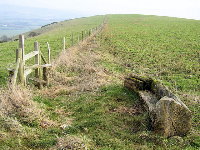
Breaky Bottom, Sussex Valley, is a picturesque vineyard located in the South Downs National Park in Sussex, England. Spanning around six acres, it is nestled within a tranquil valley surrounded by rolling hills and stunning natural beauty.

Established in 1974 by Peter and Gillian Hallgarten, Breaky Bottom has gained a reputation as one of England's finest boutique wineries. The vineyard benefits from its unique microclimate, with the chalky soil and south-facing slopes creating ideal conditions for grape cultivation.

Breaky Bottom specializes in producing high-quality sparkling wines, particularly traditional method sparkling wine made from Chardonnay, Pinot Noir, and Pinot Meunier grapes. The vineyard's commitment to quality is evident in the meticulous hand-harvesting and traditional winemaking techniques employed.

The winery's cellar houses a range of oak barrels and stainless-steel tanks, where the wines undergo fermentation and aging. With a production of around 10,000 bottles per year, Breaky Bottom focuses on small-scale, artisanal production to ensure attention to detail and exceptional taste.

Visitors to Breaky Bottom can enjoy guided tours of the vineyard, getting an insight into the winemaking process and taking in the stunning scenery. The winery also offers tastings of their award-winning wines, allowing visitors to appreciate the unique flavors and characteristics of Breaky Bottom's sparkling creations.

Breaky Bottom's dedication to quality and the natural beauty of its surroundings make it a must-visit destination for wine enthusiasts and nature lovers alike.

If you have any feedback on the listing, please let us know in the comments section below.

Breaky Bottom Images

Images are sourced within 2km of 50.828249/-0.012090075 or Grid Reference TQ4005. Thanks to Geograph Open Source API. All images are credited.

Tumulus A tumulus (plural tumuli) is a mound of earth and stones raised over a grave or graves. Tumuli are also known as barrows, burial mounds. In Britain they mainly date from Neolithic to the Bronze Age (2900 - 800BC), although some are later.
Tumulus
A tumulus (plural tumuli) is a mound of earth and stones raised over a grave or graves. Tumuli are also known as barrows, burial mounds. In Britain they mainly date from Neolithic to the Bronze Age (2900 - 800BC), although some are later.
South Downs Way The South Downs Way is a long distance footpath in Southern England and is one of Britain's National Trails. It runs for around 100 miles from Winchester in Hampshire to Eastbourne in Sussex, with a small loop around Eastbourne. The South Downs Way passes through the South Downs, a beautiful area which is now a National Park. The path mainly follows old routes and droveways along the Chalk escarpment. The majority of the path is a bridleway and so can be used by horse-riders and cyclists too. 
More information is available from <span class="nowrap"><a title="http://www.nationaltrail.co.uk/southdowns/index.asp?PageId=1" rel="nofollow ugc noopener" href="http://www.nationaltrail.co.uk/southdowns/index.asp?PageId=1">Link</a><img style="margin-left:2px;" alt="External link" title="External link - shift click to open in new window" src="https://s1.geograph.org.uk/img/external.png" width="10" height="10"/></span>
South Downs Way
The South Downs Way is a long distance footpath in Southern England and is one of Britain's National Trails. It runs for around 100 miles from Winchester in Hampshire to Eastbourne in Sussex, with a small loop around Eastbourne. The South Downs Way passes through the South Downs, a beautiful area which is now a National Park. The path mainly follows old routes and droveways along the Chalk escarpment. The majority of the path is a bridleway and so can be used by horse-riders and cyclists too. More information is available from LinkExternal link
Track on South Downs
Northease Farm
Northease Farm
South Downs Way The South Downs Way is a long distance footpath in Southern England and is one of Britain's National Trails. It runs for around 100 miles from Winchester in Hampshire to Eastbourne in Sussex, with a small loop around Eastbourne. The South Downs Way passes through the South Downs, a beautiful area which is now a National Park. The path mainly follows old routes and droveways along the Chalk escarpment. The majority of the path is a bridleway and so can be used by horse-riders and cyclists too. 
More information is available from <span class="nowrap"><a title="http://www.nationaltrail.co.uk/southdowns/index.asp?PageId=1" rel="nofollow ugc noopener" href="http://www.nationaltrail.co.uk/southdowns/index.asp?PageId=1">Link</a><img style="margin-left:2px;" alt="External link" title="External link - shift click to open in new window" src="https://s1.geograph.org.uk/img/external.png" width="10" height="10"/></span>
South Downs Way
The South Downs Way is a long distance footpath in Southern England and is one of Britain's National Trails. It runs for around 100 miles from Winchester in Hampshire to Eastbourne in Sussex, with a small loop around Eastbourne. The South Downs Way passes through the South Downs, a beautiful area which is now a National Park. The path mainly follows old routes and droveways along the Chalk escarpment. The majority of the path is a bridleway and so can be used by horse-riders and cyclists too. More information is available from LinkExternal link
Cattle on the South Downs
White Way
White Way
White Way
White Way
Breaky Bottom The South Downs is one of the four areas of chalk downland in southern England. They extend from the eastern side of Hampshire through Sussex, culminating in the cliffs at Beachy Head.
The South Downs is England's newest National Park, its designation taking effect on March 31, 2010. There are many Sites of Special Scientific Interest within the park.
The area is relatively unpopulated, although along its southern periphery there is an almost uninterrupted ribbon of seaside towns. It is extremely popular with walkers, having one principal long distance footpath, the South Downs Way, and many interconnecting ones. There are three principal gaps in the upland through which rivers flow; and there are also many dry valleys along its length.
The South Downs have a long history; there are archaeological remains from Neolithic times. Until the middle of the 20th century, sheep-rearing was the main occupation of those living on the Downs.

At 886ft, Butser Hill is the highest point of the South Downs.

Extract from Wikipedia <span class="nowrap"><a title="http://en.wikipedia.org/wiki/South_Downs" rel="nofollow ugc noopener" href="http://en.wikipedia.org/wiki/South_Downs">Link</a><img style="margin-left:2px;" alt="External link" title="External link - shift click to open in new window" src="https://s1.geograph.org.uk/img/external.png" width="10" height="10"/></span>
Breaky Bottom
The South Downs is one of the four areas of chalk downland in southern England. They extend from the eastern side of Hampshire through Sussex, culminating in the cliffs at Beachy Head. The South Downs is England's newest National Park, its designation taking effect on March 31, 2010. There are many Sites of Special Scientific Interest within the park. The area is relatively unpopulated, although along its southern periphery there is an almost uninterrupted ribbon of seaside towns. It is extremely popular with walkers, having one principal long distance footpath, the South Downs Way, and many interconnecting ones. There are three principal gaps in the upland through which rivers flow; and there are also many dry valleys along its length. The South Downs have a long history; there are archaeological remains from Neolithic times. Until the middle of the 20th century, sheep-rearing was the main occupation of those living on the Downs. At 886ft, Butser Hill is the highest point of the South Downs. Extract from Wikipedia LinkExternal link
South Downs Way crosses the Greenwich Meridian The South Downs Way is a long distance footpath in Southern England and is one of Britain's National Trails. It runs for around 100 miles from Winchester in Hampshire to Eastbourne in Sussex, with a small loop around Eastbourne. The South Downs Way passes through the South Downs, a beautiful area which is now a National Park. The path mainly follows old routes and droveways along the Chalk escarpment. The majority of the path is a bridleway and so can be used by horse-riders and cyclists too. 
More information is available from <span class="nowrap"><a title="http://www.nationaltrail.co.uk/southdowns/index.asp?PageId=1" rel="nofollow ugc noopener" href="http://www.nationaltrail.co.uk/southdowns/index.asp?PageId=1">Link</a><img style="margin-left:2px;" alt="External link" title="External link - shift click to open in new window" src="https://s1.geograph.org.uk/img/external.png" width="10" height="10"/></span>
South Downs Way crosses the Greenwich Meridian
The South Downs Way is a long distance footpath in Southern England and is one of Britain's National Trails. It runs for around 100 miles from Winchester in Hampshire to Eastbourne in Sussex, with a small loop around Eastbourne. The South Downs Way passes through the South Downs, a beautiful area which is now a National Park. The path mainly follows old routes and droveways along the Chalk escarpment. The majority of the path is a bridleway and so can be used by horse-riders and cyclists too. More information is available from LinkExternal link
View from South Downs Way
South Downs Way The South Downs Way is a long distance footpath in Southern England and is one of Britain's National Trails. It runs for around 100 miles from Winchester in Hampshire to Eastbourne in Sussex, with a small loop around Eastbourne. The South Downs Way passes through the South Downs, a beautiful area which is now a National Park. The path mainly follows old routes and droveways along the Chalk escarpment. The majority of the path is a bridleway and so can be used by horse-riders and cyclists too. 
More information is available from <span class="nowrap"><a title="http://www.nationaltrail.co.uk/southdowns/index.asp?PageId=1" rel="nofollow ugc noopener" href="http://www.nationaltrail.co.uk/southdowns/index.asp?PageId=1">Link</a><img style="margin-left:2px;" alt="External link" title="External link - shift click to open in new window" src="https://s1.geograph.org.uk/img/external.png" width="10" height="10"/></span>
South Downs Way
The South Downs Way is a long distance footpath in Southern England and is one of Britain's National Trails. It runs for around 100 miles from Winchester in Hampshire to Eastbourne in Sussex, with a small loop around Eastbourne. The South Downs Way passes through the South Downs, a beautiful area which is now a National Park. The path mainly follows old routes and droveways along the Chalk escarpment. The majority of the path is a bridleway and so can be used by horse-riders and cyclists too. More information is available from LinkExternal link
Breaky Bottom The South Downs is one of the four areas of chalk downland in southern England. They extend from the eastern side of Hampshire through Sussex, culminating in the cliffs at Beachy Head.
The South Downs is England's newest National Park, its designation taking effect on March 31, 2010. There are many Sites of Special Scientific Interest within the park.
The area is relatively unpopulated, although along its southern periphery there is an almost uninterrupted ribbon of seaside towns. It is extremely popular with walkers, having one principal long distance footpath, the South Downs Way, and many interconnecting ones. There are three principal gaps in the upland through which rivers flow; and there are also many dry valleys along its length.
The South Downs have a long history; there are archaeological remains from Neolithic times. Until the middle of the 20th century, sheep-rearing was the main occupation of those living on the Downs.

At 886ft, Butser Hill is the highest point of the South Downs.

Extract from Wikipedia <span class="nowrap"><a title="http://en.wikipedia.org/wiki/South_Downs" rel="nofollow ugc noopener" href="http://en.wikipedia.org/wiki/South_Downs">Link</a><img style="margin-left:2px;" alt="External link" title="External link - shift click to open in new window" src="https://s1.geograph.org.uk/img/external.png" width="10" height="10"/></span>
Breaky Bottom
The South Downs is one of the four areas of chalk downland in southern England. They extend from the eastern side of Hampshire through Sussex, culminating in the cliffs at Beachy Head. The South Downs is England's newest National Park, its designation taking effect on March 31, 2010. There are many Sites of Special Scientific Interest within the park. The area is relatively unpopulated, although along its southern periphery there is an almost uninterrupted ribbon of seaside towns. It is extremely popular with walkers, having one principal long distance footpath, the South Downs Way, and many interconnecting ones. There are three principal gaps in the upland through which rivers flow; and there are also many dry valleys along its length. The South Downs have a long history; there are archaeological remains from Neolithic times. Until the middle of the 20th century, sheep-rearing was the main occupation of those living on the Downs. At 886ft, Butser Hill is the highest point of the South Downs. Extract from Wikipedia LinkExternal link
Bridleway crosses South Downs Way
South Farm
South Farm
Show me another place!

Breaky Bottom is located at Grid Ref: TQ4005 (Lat: 50.828249, Lng: -0.012090075)

Administrative County: East Sussex

District: Lewes

Police Authority: Sussex

What 3 Words

///closet.nets.grief. Near Rottingdean, East Sussex

Nearby Locations

Breaky Bottom

Related Wikis

Brighton Kemptown (UK Parliament constituency)

Brighton Kemptown, often referred to as Brighton Kemptown and Peacehaven by local political parties, is a constituency represented in the House of Commons...

Rodmell

Rodmell is a small village and civil parish in the Lewes District of East Sussex, England. It is located three miles (4.8 km) south-west of Lewes, on the...

Saltdean United F.C.

Saltdean United Football Club is a football club based in Saltdean in the city of Brighton & Hove on the south coast of England. They are currently members...

Kingston Escarpment and Iford Hill

Kingston Escarpment and Iford Hill is a 63.4-hectare (157-acre) biological Site of Special Scientific Interest east of Brighton in East Sussex.These two...

Southease

Southease is a small village and civil parish in East Sussex, in South East England between the A26 road and the C7 road from Lewes to Newhaven. The village...
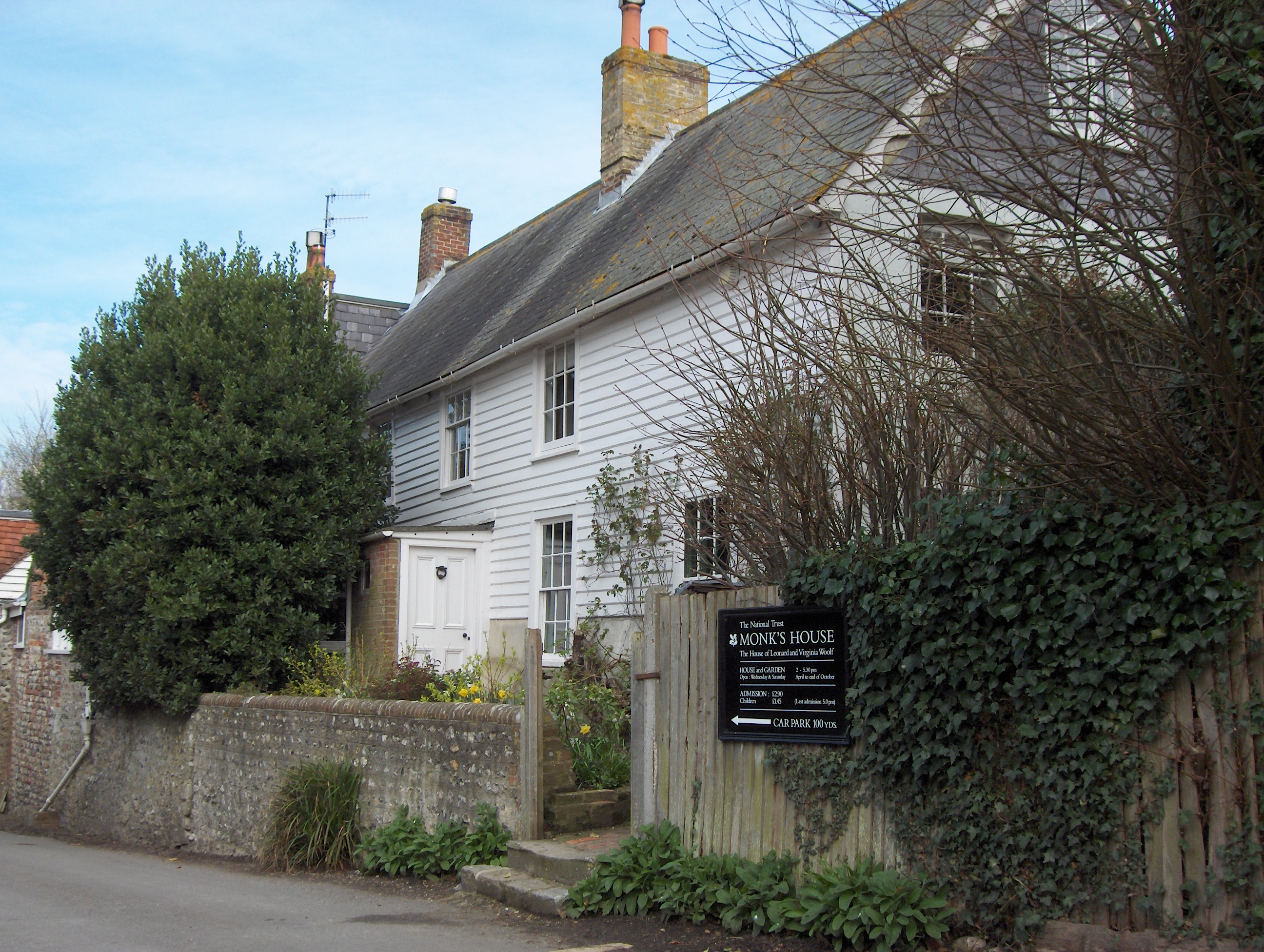
Monk's House

Monk's House is a 16th-century weatherboarded cottage in the village of Rodmell, three miles (4.8 km) south of Lewes, East Sussex, England. The writer...

St Nicholas Church, Iford

The Church of St Nicholas is an Anglican church in the village of Iford, East Sussex, England. It is in the Diocese of Chichester, and in the United Benefice...

St Peter's Church, Rodmell

St Peter's Church is the parish church of Rodmell, East Sussex, England, and dates from the 12th century. It is a Grade I listed building and is among...

Nearby Amenities

Located within 500m of 50.828249,-0.012090075
Created By: Potlatch 0.10f
Historic: archaeological_site
Source: NPE
Lat/Long: 50.8295943/-0.0187444
Created By: Potlatch 0.10f
Historic: archaeological_site
Source: NPE
Lat/Long: 50.8274257/-0.0163411
Breaky Bottom
Created By: Potlatch 0.10f
Place: locality
Lat/Long: 50.8290793/-0.0066422
Created By: Potlatch 0.10f
Historic: archaeological_site
Source: NPE
Lat/Long: 50.8268836/-0.0111054
Barrier: stile
Lat/Long: 50.8305405/-0.0079215
Barrier: stile
Lat/Long: 50.8306093/-0.0074703
Power: pole
Source: gps;Bing
Lat/Long: 50.8289612/-0.0051919
Power: pole
Lat/Long: 50.8294177/-0.006263
The data included in this document is from www.openstreetmap.org. The data is made available under ODbL.

Have you been to Breaky Bottom?

Leave your review of Breaky Bottom below (or comments, questions and feedback).