Hawk's Den

Valley in Sussex Mid Sussex

England

Hawk's Den

The White Hart Can't miss it. On the road south from Turners Hill which is known as the Ardingly road or sometimes Selsfield Road !
The White Hart Credit: Nigel Freeman

Hawk's Den, Sussex (Valley) is a picturesque and serene location nestled in the beautiful countryside of Sussex County, England. This charming valley is situated on the southern edge of the South Downs National Park, offering visitors breathtaking views of rolling hills, lush greenery, and an abundance of wildlife.

The highlight of Hawk's Den is undoubtedly its stunning cliffs, which tower above the valley floor and provide a dramatic backdrop to the landscape. These cliffs are a popular destination for rock climbers and hikers, offering challenging routes and rewarding vistas at the top. The valley itself is crisscrossed by a network of walking trails, allowing visitors to explore its hidden gems at their own pace.

Nature enthusiasts will be delighted by the variety of wildlife that calls Hawk's Den home. The valley is known for its diverse bird population, including majestic birds of prey such as hawks and falcons, which can often be spotted soaring above the cliffs. The surrounding woodlands are home to a plethora of animals, including deer, foxes, and badgers, making it a haven for wildlife lovers.

In addition to its natural beauty, Hawk's Den is also steeped in history. The valley has been inhabited for centuries, and remnants of ancient settlements can still be found scattered throughout the area. The nearby village of Sussex offers a glimpse into the region's past, with its quaint cottages, historic churches, and charming pubs.

Overall, Hawk's Den, Sussex (Valley) is a haven for nature enthusiasts, history buffs, and those seeking a tranquil retreat. With its stunning cliffs, abundant wildlife, and rich history, this hidden gem in the Sussex countryside is a must-visit destination for anyone looking to escape the hustle and bustle of everyday life.

If you have any feedback on the listing, please let us know in the comments section below.

Hawk's Den Images

Images are sourced within 2km of 51.081226/-0.07606493 or Grid Reference TQ3433. Thanks to Geograph Open Source API. All images are credited.
The White Hart Can't miss it. On the road south from Turners Hill which is known as the Ardingly road or sometimes Selsfield Road !
The White Hart
Can't miss it. On the road south from Turners Hill which is known as the Ardingly road or sometimes Selsfield Road !
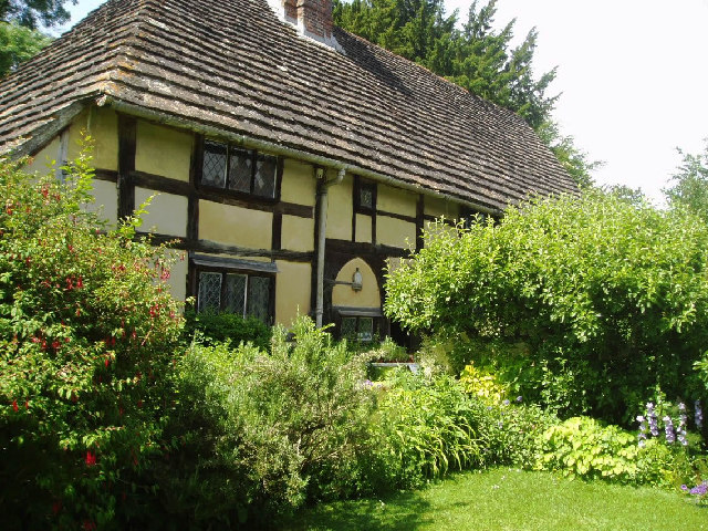
Priest House at West Hoathly Early 15th century dwelling which originally belonged to the clergy but in Elizabethan times was modernised into a substantial Yeomen’s dwelling. It is now a museum containing a fascinating array of domestic country furniture, kitchen equipment, needlework and household items. Outside there is a formal herb garden containing over 150 culinary, medicinal and folklore herbs. <span class="nowrap"><a title="www.sussexpast.co.uk" rel="nofollow ugc noopener" href="http://www.sussexpast.co.uk">Link</a><img style="margin-left:2px;" alt="External link" title="External link - shift click to open in new window" src="https://s1.geograph.org.uk/img/external.png" width="10" height="10"/></span>
Priest House at West Hoathly
Early 15th century dwelling which originally belonged to the clergy but in Elizabethan times was modernised into a substantial Yeomen’s dwelling. It is now a museum containing a fascinating array of domestic country furniture, kitchen equipment, needlework and household items. Outside there is a formal herb garden containing over 150 culinary, medicinal and folklore herbs. LinkExternal link
St Margarets at West Hoathly Of 12th century origins, it stands on high ground with magnificent and peaceful graveyard. Next door is the Cat public house serving food and drink.
St Margarets at West Hoathly
Of 12th century origins, it stands on high ground with magnificent and peaceful graveyard. Next door is the Cat public house serving food and drink.
Wakehurst Place entrance A well known entrance for the many visitors who come to enjoy the Royal Botanic Gardens country home.
Wakehurst Place entrance
A well known entrance for the many visitors who come to enjoy the Royal Botanic Gardens country home.
Views to the South Downs from the Weald Hook Lane leads down from West Hoathly to Ardingly. It's a narrow road and passes farmyards and woodland. From a bend in the road, you can enjoy the distant scenery.
Views to the South Downs from the Weald
Hook Lane leads down from West Hoathly to Ardingly. It's a narrow road and passes farmyards and woodland. From a bend in the road, you can enjoy the distant scenery.
Priest House at West Hoathly Notice the roof made from Horsham Stone or perhaps more correctly called Slate - a natural product from the area and used widely for roofing from medieval times.
Priest House at West Hoathly
Notice the roof made from Horsham Stone or perhaps more correctly called Slate - a natural product from the area and used widely for roofing from medieval times.
The Selsfield Road near West Hoathly This road is twisty and narrow and, in the summer especially, is very shaded where the trees overhang.
The Selsfield Road near West Hoathly
This road is twisty and narrow and, in the summer especially, is very shaded where the trees overhang.
Gravetye Manor Hotel This is an exclusive hotel in a glorious setting only 30 miles from the centre of London. <span class="nowrap"><a title="www.gravetyemanor.co.uk" rel="nofollow ugc noopener" href="http://www.gravetyemanor.co.uk">Link</a><img style="margin-left:2px;" alt="External link" title="External link - shift click to open in new window" src="https://s1.geograph.org.uk/img/external.png" width="10" height="10"/></span>
Gravetye Manor Hotel
This is an exclusive hotel in a glorious setting only 30 miles from the centre of London. LinkExternal link
Footpath sign near Newhouse Farm Here there is a choice of paths.
Footpath sign near Newhouse Farm
Here there is a choice of paths.
Footbridge over the stream Deep in the woods a new footbridge
Footbridge over the stream
Deep in the woods a new footbridge
Footpath over the field Here the footpath takes the direct route across a field.
Footpath over the field
Here the footpath takes the direct route across a field.
Water Tower A brick built Victorian tower.
Water Tower
A brick built Victorian tower.
Grazing field near West Hoathly The lane on the left leads from West Hoathly village to Philpots Manor School, Philpots Quarry and Philpots Farm (all behind camera)
Grazing field near West Hoathly
The lane on the left leads from West Hoathly village to Philpots Manor School, Philpots Quarry and Philpots Farm (all behind camera)
Entrance to Philpots Quarry The actual quarry is over the ridge and has some trees obscuring the view from the lane.
Entrance to Philpots Quarry
The actual quarry is over the ridge and has some trees obscuring the view from the lane.
Wakehurst Place Kew Subsidiary Garden on a very rainy day  This is the view over the Mansion Pond back towards the house.
Wakehurst Place
Kew Subsidiary Garden on a very rainy day This is the view over the Mansion Pond back towards the house.
Wakehurst Place Visitor centre and shop.
Wakehurst Place
Visitor centre and shop.
The House at Wakehurst Place
Rock Walk At Wakehurst Place
Rock Walk
At Wakehurst Place
Show me another place!

Hawk's Den is located at Grid Ref: TQ3433 (Lat: 51.081226, Lng: -0.07606493)

Administrative County: West Sussex

District: Mid Sussex

Police Authority: Sussex

What 3 Words

///chains.solids.tint. Near Ardingly, West Sussex

Related Wikis

Philpot's and Hook Quarries

Philpot's and Hook Quarries is a 2.6-hectare (6.4-acre) geological Site of Special Scientific Interest south-west of Sharpthorne in West Sussex. It is...

St Margaret's Church, West Hoathly

St Margaret's Church (dedicated in full to St Margaret of Antioch) is an Anglican church in the village of West Hoathly in Mid Sussex, one of seven local...

The Priest House, West Hoathly

The Priest House is a Grade II* listed fifteenth century timber framed hall house in the centre of West Hoathly, in West Sussex, England. It is close to...

Wakehurst and Chiddingly Woods

Wakehurst and Chiddingly Woods is a 155.9-hectare (385-acre) biological and geological Site of Special Scientific Interest south-east of Crawley in West...

Gravetye Manor

Gravetye Manor is a manor house located near East Grinstead, West Sussex, England. The former home of landscape gardener William Robinson, it is now a...

West Hoathly

West Hoathly is a village and civil parish in the Mid Sussex District of West Sussex, England, located 3.5 miles (5.6 km) south west of East Grinstead...

Millennium Seed Bank Partnership

The Millennium Seed Bank Partnership (MSBP or MSB), formerly known as the Millennium Seed Bank Project, is the largest ex situ plant conservation programme...

Wakehurst Place

Wakehurst, previously known as Wakehurst Place, is a house and botanic gardens in West Sussex, England, owned by the National Trust but used and managed...

Nearby Amenities

Located within 500m of 51.081226,-0.07606493
White Hart PH
Naptan AtcoCode: 4400EG0159
Naptan Bearing: S
Naptan BusStopType: CUS
Naptan CommonName: White Hart PH
Naptan Indicator: o/s White Hart
Naptan Landmark: White Hart Pub
Naptan NaptanCode: wsxapagd
Naptan Street: B2028
Naptan Verified: no
Note: no evidence of this on the ground
Old Highway: bus_stop
Source: naptan_import
Lat/Long: 51.0816976/-0.0783407
Bus Stop
Selsfield Road B2028
Bus: yes
Naptan AtcoCode: 4400EG0391
Naptan Bearing: S
Naptan BusStopType: CUS
Naptan CommonName: Selsfield Road B2028
Naptan Indicator: HAR
Naptan Landmark: Hail & Ride
Naptan NaptanCode: wsxdwtat
Naptan Street: Selsfield Road B2028
Naptan Verified: no
Public Transport: platform
Shelter: no
Source: naptan_import
Lat/Long: 51.085595/-0.0763514
Bus Stop
Selsfield Road B2028
Bus: yes
Naptan AtcoCode: 4400EG0392
Naptan Bearing: N
Naptan BusStopType: CUS
Naptan CommonName: Selsfield Road B2028
Naptan Indicator: HAR
Naptan Landmark: Hail & Ride
Naptan NaptanCode: wsxdwtaw
Naptan Street: Selsfield Road B2028
Naptan Verified: no
Public Transport: platform
Shelter: no
Source: naptan_import
Lat/Long: 51.0856241/-0.0764787
Barrier: stile
Lat/Long: 51.0781641/-0.0712866
Barrier: kissing_gate
Material: metal
Lat/Long: 51.0803238/-0.0723379
Barrier: stile
Foot: yes
Material: stone
Stile: stepover
Lat/Long: 51.0826808/-0.0777831
Stonelands
Place: locality
Source: OS OpenData StreetView
Wikidata: Q26573378
Lat/Long: 51.083061/-0.0723464
Barrier: stile
Foot: yes
Material: wood
Stile: stepover
Lat/Long: 51.0809624/-0.0739213
Barrier: stile
Foot: yes
Material: wood
Stile: stepover
Lat/Long: 51.0814731/-0.0755971
Barrier: stile
Lat/Long: 51.082819/-0.0726543
Barrier: stile
Lat/Long: 51.0829844/-0.0741915
Power: pole
Lat/Long: 51.0808325/-0.0785238
Power: pole
Lat/Long: 51.0807465/-0.0773955
Power: pole
Lat/Long: 51.0806729/-0.0757615
Power: pole
Lat/Long: 51.0807072/-0.0750094
Power: pole
Lat/Long: 51.0807391/-0.0744458
Power: pole
Lat/Long: 51.0810058/-0.0738846
Barrier: kissing_gate
Lat/Long: 51.0824501/-0.0715987
Barrier: stile
Stile: stepover
Lat/Long: 51.082473/-0.0715454
The data included in this document is from www.openstreetmap.org. The data is made available under ODbL.

Have you been to Hawk's Den?

Leave your review of Hawk's Den below (or comments, questions and feedback).