Middlehope Bottom

Valley in Durham

England

Middlehope Bottom

Trig Pillar, Carr Brow
Trig Pillar, Carr Brow Credit: David Brown

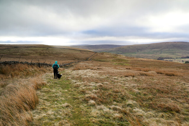
Middlehope Bottom is a small valley located in the county of Durham, England. Situated in the northern part of the county, this picturesque area is surrounded by rolling hills and lush greenery, creating a tranquil and idyllic setting.

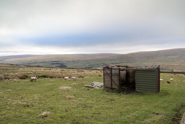
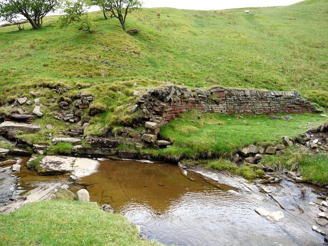
The valley itself is named after the nearby village of Middlehope, which lies at the heart of the area. Middlehope Bottom is characterized by its charming rural landscape, with vast meadows and meandering streams that flow through the valley. The valley is also dotted with a few scattered farms, adding to its rustic charm.

The area is a haven for nature enthusiasts, offering a plethora of walking trails and hiking routes. Visitors can explore the various footpaths that crisscross the valley, providing breathtaking views of the surrounding countryside. In addition, Middlehope Bottom is home to a diverse range of flora and fauna, making it an ideal spot for wildlife observation and birdwatching.

Despite its rural setting, Middlehope Bottom is conveniently located close to several towns and villages, providing easy access to amenities and services. The bustling town of Durham is just a short drive away, offering a wide range of shops, restaurants, and cultural attractions.

Overall, Middlehope Bottom in Durham is a hidden gem for those seeking a peaceful retreat in the heart of the English countryside. With its stunning natural beauty and proximity to amenities, it is a destination that appeals to both locals and visitors alike.

If you have any feedback on the listing, please let us know in the comments section below.

Middlehope Bottom Images

Images are sourced within 2km of 54.762259/-2.1632988 or Grid Reference NY8940. Thanks to Geograph Open Source API. All images are credited.

Trig Pillar, Carr Brow
Carr Brow Moor
Carr Brow Moor
Moorland above St John's Chapel, Stanhope The public bridleway crossing the flank of Carr Brow Moor.
Moorland above St John's Chapel, Stanhope
The public bridleway crossing the flank of Carr Brow Moor.
Bridleway over Carr Brow Moor From Middlehope Bank (the minor road from Rookhope to Ireshopeburn) the bridleway gives good walking down towards Levelgate Sike and up over the shoulder of Bleak Laws on Carr Brow Moor. Just beyond the horizon, it passes through a gate and becomes a more substantial track, rather cut up by big tractor tyres, making the descent into Weardale a bit more wearing than the pleasant going on the moor.
Bridleway over Carr Brow Moor
From Middlehope Bank (the minor road from Rookhope to Ireshopeburn) the bridleway gives good walking down towards Levelgate Sike and up over the shoulder of Bleak Laws on Carr Brow Moor. Just beyond the horizon, it passes through a gate and becomes a more substantial track, rather cut up by big tractor tyres, making the descent into Weardale a bit more wearing than the pleasant going on the moor.
Not much shelter left This disused railway goods van shell has been here long enough to be mapped by the OS, but in that time, the weather has done it no good at all. With parts of the roof falling in, and part blown off, it may provide shelter from the wind for a few sheep, but certainly won't keep the rain or snow off. One panel seems to have been replaced by corrugated iron, but it looks as though the owner has decided that further repair is pointless. One hopes that on its final demise, it is removed and metal parts suitably recycled, not left here to rust and rot away completely.
Not much shelter left
This disused railway goods van shell has been here long enough to be mapped by the OS, but in that time, the weather has done it no good at all. With parts of the roof falling in, and part blown off, it may provide shelter from the wind for a few sheep, but certainly won't keep the rain or snow off. One panel seems to have been replaced by corrugated iron, but it looks as though the owner has decided that further repair is pointless. One hopes that on its final demise, it is removed and metal parts suitably recycled, not left here to rust and rot away completely.
Remains  of 'bouseteams', Low Slitt Mine Remains of two sets of bouseteams where the partnerships, or independent groups of miners stored their bouse (unprocessed lead ore) from the Low Slitt Mine. The miners were paid for lead content of the ore, retrieved by a crushing and washing process.

The structures at Low Slitt Mine are still undergoing consolidation and restoration work under the auspices of Natural England as can be seen from the newly pointed masonry. The bouseteams here are considered to be the best surviving set of such structures in the North Pennines.

There are other photos here from 1990 <a href="https://www.geograph.org.uk/photo/73388">NY9039 : Slitt Mine</a> and 2009 <a href="https://www.geograph.org.uk/photo/1392053">NY9039 : Part of the Low Slit Lead Mine</a>
Remains of 'bouseteams', Low Slitt Mine
Remains of two sets of bouseteams where the partnerships, or independent groups of miners stored their bouse (unprocessed lead ore) from the Low Slitt Mine. The miners were paid for lead content of the ore, retrieved by a crushing and washing process. The structures at Low Slitt Mine are still undergoing consolidation and restoration work under the auspices of Natural England as can be seen from the newly pointed masonry. The bouseteams here are considered to be the best surviving set of such structures in the North Pennines. There are other photos here from 1990 NY9039 : Slitt Mine and 2009 NY9039 : Part of the Low Slit Lead Mine
Spring Sandwort (Minuartia verna), Low Slitt Mine This little plant <span class="nowrap"><a title="http://species.wikimedia.org/wiki/Minuartia_verna" rel="nofollow ugc noopener" href="http://species.wikimedia.org/wiki/Minuartia_verna">Link</a><img style="margin-left:2px;" alt="External link" title="External link - shift click to open in new window" src="https://s1.geograph.org.uk/img/external.png" width="10" height="10"/></span> is locally common here growing on the almost bare stony soil of the former washing floor of the Low Slitt Lead Mine in the valley of the Middlehope Burn <a href="https://www.geograph.org.uk/photo/2409229">NY9039 : Former washing floor of Low Slitt Lead Mine</a>. Because of the high levels of toxic heavy metal elements in the soil, few other plants can grow. Spring Sandwort (locally, 'Leadwort') is however, a metallophyte, specifically adapted to these conditions, and grows on lead mine spoil heaps all over the north of England and in a few other places with special conditions <span class="nowrap"><a title="http://data.nbn.org.uk/gridMap/gridMap.jsp?allDs=1&srchSpKey=NBNSYS0000003052" rel="nofollow ugc noopener" href="http://data.nbn.org.uk/gridMap/gridMap.jsp?allDs=1&srchSpKey=NBNSYS0000003052">Link</a><img style="margin-left:2px;" alt="External link" title="External link - shift click to open in new window" src="https://s1.geograph.org.uk/img/external.png" width="10" height="10"/></span>
<span class="nowrap"><a title="http://www.ieem.net/docs/08%20Janet%20Simpkin.pdf" rel="nofollow ugc noopener" href="http://www.ieem.net/docs/08%20Janet%20Simpkin.pdf">Link</a><img style="margin-left:2px;" alt="External link" title="External link - shift click to open in new window" src="https://s1.geograph.org.uk/img/external.png" width="10" height="10"/></span>
Spring Sandwort (Minuartia verna), Low Slitt Mine
This little plant LinkExternal link is locally common here growing on the almost bare stony soil of the former washing floor of the Low Slitt Lead Mine in the valley of the Middlehope Burn NY9039 : Former washing floor of Low Slitt Lead Mine. Because of the high levels of toxic heavy metal elements in the soil, few other plants can grow. Spring Sandwort (locally, 'Leadwort') is however, a metallophyte, specifically adapted to these conditions, and grows on lead mine spoil heaps all over the north of England and in a few other places with special conditions LinkExternal link LinkExternal link
Former washing floor of Low Slitt Lead Mine The bare ground and short, rabbit-grazed grassland that has colonised this heavily contaminated area beside the Middlehope Burn is the habitat of <a href="https://www.geograph.org.uk/photo/2409193">NY9039 : Spring Sandwort (Minuartia verna), Low Slitt Mine</a>
Former washing floor of Low Slitt Lead Mine
The bare ground and short, rabbit-grazed grassland that has colonised this heavily contaminated area beside the Middlehope Burn is the habitat of NY9039 : Spring Sandwort (Minuartia verna), Low Slitt Mine
Panorama from the site of Low Slitt Lead Mine 7 photos were stitched to build the panorama which can be zoomed into here <span class="nowrap"><a title="http://zoom.it/hNywG" rel="nofollow ugc noopener" href="http://zoom.it/hNywG">Link</a><img style="margin-left:2px;" alt="External link" title="External link - shift click to open in new window" src="https://s1.geograph.org.uk/img/external.png" width="10" height="10"/></span>

Low Slitt Mine was worked until 1882, although most production had ceased by 1872 <span class="nowrap"><a title="http://www.keystothepast.info/article/10339/Site-Details?PRN=D46" rel="nofollow ugc noopener" href="http://www.keystothepast.info/article/10339/Site-Details?PRN=D46">Link</a><img style="margin-left:2px;" alt="External link" title="External link - shift click to open in new window" src="https://s1.geograph.org.uk/img/external.png" width="10" height="10"/></span>

The Middlehope Burn can be seen on the left and right sides as it curves around the site of the former washing floor used to separate lead from the ore. This area is home to the nationally rare <a href="https://www.geograph.org.uk/photo/2409193">NY9039 : Spring Sandwort (Minuartia verna), Low Slitt Mine</a> whose tiny white flowers dot the bare soil and short grass.

On the right, edges of the remaining walls of the bouseteams are just visible <a href="https://www.geograph.org.uk/photo/2409141">NY9039 : Remains  of 'bouseteams', Low Slitt Mine</a> These storage pits would have been fed by a waggonway running above them which carried tubs of ore directly from the pit shaft. This is visible as a fenced area of trees on the far bank of the burn to the left. The shaft was nearly 200m deep and accessed using ladders. Beyond and largely hidden from view is the huge water wheel pit which used water power to pump water from the mine <a href="https://www.geograph.org.uk/photo/2409487">NY9039 : Remains of waterwheel pit, Low Slitt Lead Mine</a>

On the right hand side of the mound in the centre of the photo is the former Blacksmith's Shop which still has remains of the forge. Another set of demolished bouseteams are visible abutting the wall below the building <a href="https://www.geograph.org.uk/photo/2409599">NY9039 : Ruin of Blacksmith's Shop, Low Slitt Lead Mine</a>

In line with the track at the centre of the photo is the Engine House which housed a water-driven Armstrong hydraulic engine installed in a late phase of mine development in the 1860s to help pull tubs of ore up the shaft. The burn is arched over at this point to provide a greater working area <a href="https://www.geograph.org.uk/photo/2409449">NY9039 : Middlehope Burn at Low Slitt Lead Mine</a>
Panorama from the site of Low Slitt Lead Mine
7 photos were stitched to build the panorama which can be zoomed into here LinkExternal link Low Slitt Mine was worked until 1882, although most production had ceased by 1872 LinkExternal link The Middlehope Burn can be seen on the left and right sides as it curves around the site of the former washing floor used to separate lead from the ore. This area is home to the nationally rare NY9039 : Spring Sandwort (Minuartia verna), Low Slitt Mine whose tiny white flowers dot the bare soil and short grass. On the right, edges of the remaining walls of the bouseteams are just visible NY9039 : Remains of 'bouseteams', Low Slitt Mine These storage pits would have been fed by a waggonway running above them which carried tubs of ore directly from the pit shaft. This is visible as a fenced area of trees on the far bank of the burn to the left. The shaft was nearly 200m deep and accessed using ladders. Beyond and largely hidden from view is the huge water wheel pit which used water power to pump water from the mine NY9039 : Remains of waterwheel pit, Low Slitt Lead Mine On the right hand side of the mound in the centre of the photo is the former Blacksmith's Shop which still has remains of the forge. Another set of demolished bouseteams are visible abutting the wall below the building NY9039 : Ruin of Blacksmith's Shop, Low Slitt Lead Mine In line with the track at the centre of the photo is the Engine House which housed a water-driven Armstrong hydraulic engine installed in a late phase of mine development in the 1860s to help pull tubs of ore up the shaft. The burn is arched over at this point to provide a greater working area NY9039 : Middlehope Burn at Low Slitt Lead Mine
Middlehope Burn at Low Slitt Lead Mine In the centre, there is a window in the culverted Middlehope Burn built on the facing side with an amazing flat arch to provide a greater working area in the narrow stream valley. I'm not sure what the purpose was for the window down to the burn. On the left is the fenced area of the original mine shaft with newly pointed stone work behind which would have housed a huge water wheel. The large stone blocks on the right would have held the winding drum driven by a hydraulic engine <a href="https://www.geograph.org.uk/photo/2409449">NY9039 : Middlehope Burn at Low Slitt Lead Mine</a>
Middlehope Burn at Low Slitt Lead Mine
In the centre, there is a window in the culverted Middlehope Burn built on the facing side with an amazing flat arch to provide a greater working area in the narrow stream valley. I'm not sure what the purpose was for the window down to the burn. On the left is the fenced area of the original mine shaft with newly pointed stone work behind which would have housed a huge water wheel. The large stone blocks on the right would have held the winding drum driven by a hydraulic engine NY9039 : Middlehope Burn at Low Slitt Lead Mine
Middlehope Burn at Low Slitt Lead Mine The burn here flows in a tunnel broken here by a deep window where the arched masonry can be seen. The ruined structure with huge stone blocks on the left housed a winding gear driven by one of Armstrong's hydraulic engines <span class="nowrap"><a title="http://www.aqpl43.dsl.pipex.com/MUSEUM/POWER/waterengine/waterengine3.htm" rel="nofollow ugc noopener" href="http://www.aqpl43.dsl.pipex.com/MUSEUM/POWER/waterengine/waterengine3.htm">Link</a><img style="margin-left:2px;" alt="External link" title="External link - shift click to open in new window" src="https://s1.geograph.org.uk/img/external.png" width="10" height="10"/></span> behind powered by water flowing down a cast-iron pipe from the reservoir high on the west bank of the Middlehope valley. The track on the right rises from the valley east to the fell road in the region of the iron ore mines at Slitt Pasture.
Middlehope Burn at Low Slitt Lead Mine
The burn here flows in a tunnel broken here by a deep window where the arched masonry can be seen. The ruined structure with huge stone blocks on the left housed a winding gear driven by one of Armstrong's hydraulic engines LinkExternal link behind powered by water flowing down a cast-iron pipe from the reservoir high on the west bank of the Middlehope valley. The track on the right rises from the valley east to the fell road in the region of the iron ore mines at Slitt Pasture.
Middlehope Burn at Low Slitt Lead Mine Entrance to the tunnelled part of the Middlehope Burn as it passes through the main area of the Low Slitt Mine. The wide bridge has been built with a long flat arch.
Middlehope Burn at Low Slitt Lead Mine
Entrance to the tunnelled part of the Middlehope Burn as it passes through the main area of the Low Slitt Mine. The wide bridge has been built with a long flat arch.
Remains of waterwheel pit, Low Slitt Lead Mine A large waterwheel here turned in the gently curved groove in the end stonework parallel to the back wall, probably similar to the overshot wheel at Killhope <a href="https://www.geograph.org.uk/photo/1095217">NY8242 : Killhope Lead Mining Museum</a>. The source of water was probably a dam on the main burn to the north <a href="https://www.geograph.org.uk/photo/2409560">NY9039 : Remains of dam on Middlehope Burn above Low Slitt Mine</a> as the mill pond (West Slitt Dam) high on the west side of the valley <a href="https://www.geograph.org.uk/photo/642636">NY9039 : Pond above the Slit Mine</a> was constructed later, probably to power the Hydraulic Engine. 

Conservation work is still taking place to consolidate the structure. The wheel was used to drive a pump to drain the mine, the shaft of which is in the wooded fenced area on the left.
Remains of waterwheel pit, Low Slitt Lead Mine
A large waterwheel here turned in the gently curved groove in the end stonework parallel to the back wall, probably similar to the overshot wheel at Killhope NY8242 : Killhope Lead Mining Museum. The source of water was probably a dam on the main burn to the north NY9039 : Remains of dam on Middlehope Burn above Low Slitt Mine as the mill pond (West Slitt Dam) high on the west side of the valley NY9039 : Pond above the Slit Mine was constructed later, probably to power the Hydraulic Engine. Conservation work is still taking place to consolidate the structure. The wheel was used to drive a pump to drain the mine, the shaft of which is in the wooded fenced area on the left.
Remains of dam on Middlehope Burn above Low Slitt Mine Part of the former mill pond further up the valley is shown here <a href="https://www.geograph.org.uk/photo/2409633">NY9039 : Middlehope Burn north of Low Slitt Mine</a>
Remains of dam on Middlehope Burn above Low Slitt Mine
Part of the former mill pond further up the valley is shown here NY9039 : Middlehope Burn north of Low Slitt Mine
Ruin of Blacksmith's Shop, Low Slitt Lead Mine The North Pennines Area of Outstanding Natural Beauty (AONB) became the first area in Britain to be awarded the status of European Geopark in June 2003 and was a founding member of the Global Geoparks Network in 2004.
<span class="nowrap"><a title="http://www.northpennines.org.uk/Pages/Home.aspx" rel="nofollow ugc noopener" href="http://www.northpennines.org.uk/Pages/Home.aspx">Link</a><img style="margin-left:2px;" alt="External link" title="External link - shift click to open in new window" src="https://s1.geograph.org.uk/img/external.png" width="10" height="10"/></span>

The three mile Geotrail from Westgate north along the Middlehope Burn including the lead mining area of Slitt Wood and West Rigg Opencut.
An audio-visual guide can be downloaded here:
<span class="nowrap"><a title="http://www.northpennines.org.uk/Pages/SlittWoodvideoguide.aspx" rel="nofollow ugc noopener" href="http://www.northpennines.org.uk/Pages/SlittWoodvideoguide.aspx">Link</a><img style="margin-left:2px;" alt="External link" title="External link - shift click to open in new window" src="https://s1.geograph.org.uk/img/external.png" width="10" height="10"/></span>

In 1997, Low Slitt became a scheduled monument protected by law and classified as of national importance. In 2008, a partnership between the landowner, Natural England and English Heritage was formed to consolidate the site and preserve the remains.

West Rigg Open Cutting SSSI <span class="nowrap"><a title="http://www.english-nature.org.uk/citation/citation_photo/1001299.pdf" rel="nofollow ugc noopener" href="http://www.english-nature.org.uk/citation/citation_photo/1001299.pdf">Link</a><img style="margin-left:2px;" alt="External link" title="External link - shift click to open in new window" src="https://s1.geograph.org.uk/img/external.png" width="10" height="10"/></span>

English Heritage Scheduled Monument, Middlehope Shield and Low Slit lead mines and ore works (1015825): <span class="nowrap"><a title="https://historicengland.org.uk/listing/the-list/list-entry/1015825" rel="nofollow ugc noopener" href="https://historicengland.org.uk/listing/the-list/list-entry/1015825">Link</a><img style="margin-left:2px;" alt="External link" title="External link - shift click to open in new window" src="https://s1.geograph.org.uk/img/external.png" width="10" height="10"/></span>
Ruin of Blacksmith's Shop, Low Slitt Lead Mine
The North Pennines Area of Outstanding Natural Beauty (AONB) became the first area in Britain to be awarded the status of European Geopark in June 2003 and was a founding member of the Global Geoparks Network in 2004. LinkExternal link The three mile Geotrail from Westgate north along the Middlehope Burn including the lead mining area of Slitt Wood and West Rigg Opencut. An audio-visual guide can be downloaded here: LinkExternal link In 1997, Low Slitt became a scheduled monument protected by law and classified as of national importance. In 2008, a partnership between the landowner, Natural England and English Heritage was formed to consolidate the site and preserve the remains. West Rigg Open Cutting SSSI LinkExternal link English Heritage Scheduled Monument, Middlehope Shield and Low Slit lead mines and ore works (1015825): LinkExternal link
Middlehope Burn north of Low Slitt Mine The flat area beside the burn was the north part of the pond dammed lower down which probably provided power for the first waterwheel <a href="https://www.geograph.org.uk/photo/2409560">NY9039 : Remains of dam on Middlehope Burn above Low Slitt Mine</a>

The pond and sluice along with a system of aqueducts carrying water from the west are shown on the 1865 1:10560 OS Map
Middlehope Burn north of Low Slitt Mine
The flat area beside the burn was the north part of the pond dammed lower down which probably provided power for the first waterwheel NY9039 : Remains of dam on Middlehope Burn above Low Slitt Mine The pond and sluice along with a system of aqueducts carrying water from the west are shown on the 1865 1:10560 OS Map
Early-purple Orchid (Orchis mascula) above Middlehope Burn The North Pennines Area of Outstanding Natural Beauty (AONB) became the first area in Britain to be awarded the status of European Geopark in June 2003 and was a founding member of the Global Geoparks Network in 2004.
<span class="nowrap"><a title="http://www.northpennines.org.uk/Pages/Home.aspx" rel="nofollow ugc noopener" href="http://www.northpennines.org.uk/Pages/Home.aspx">Link</a><img style="margin-left:2px;" alt="External link" title="External link - shift click to open in new window" src="https://s1.geograph.org.uk/img/external.png" width="10" height="10"/></span>

The three mile Geotrail from Westgate north along the Middlehope Burn including the lead mining area of Slitt Wood and West Rigg Opencut.
An audio-visual guide can be downloaded here:
<span class="nowrap"><a title="http://www.northpennines.org.uk/Pages/SlittWoodvideoguide.aspx" rel="nofollow ugc noopener" href="http://www.northpennines.org.uk/Pages/SlittWoodvideoguide.aspx">Link</a><img style="margin-left:2px;" alt="External link" title="External link - shift click to open in new window" src="https://s1.geograph.org.uk/img/external.png" width="10" height="10"/></span>

In 1997, Low Slitt became a scheduled monument protected by law and classified as of national importance. In 2008, a partnership between the landowner, Natural England and English Heritage was formed to consolidate the site and preserve the remains.

West Rigg Open Cutting SSSI <span class="nowrap"><a title="http://www.english-nature.org.uk/citation/citation_photo/1001299.pdf" rel="nofollow ugc noopener" href="http://www.english-nature.org.uk/citation/citation_photo/1001299.pdf">Link</a><img style="margin-left:2px;" alt="External link" title="External link - shift click to open in new window" src="https://s1.geograph.org.uk/img/external.png" width="10" height="10"/></span>

English Heritage Scheduled Monument, Middlehope Shield and Low Slit lead mines and ore works (1015825): <span class="nowrap"><a title="https://historicengland.org.uk/listing/the-list/list-entry/1015825" rel="nofollow ugc noopener" href="https://historicengland.org.uk/listing/the-list/list-entry/1015825">Link</a><img style="margin-left:2px;" alt="External link" title="External link - shift click to open in new window" src="https://s1.geograph.org.uk/img/external.png" width="10" height="10"/></span>
Early-purple Orchid (Orchis mascula) above Middlehope Burn
The North Pennines Area of Outstanding Natural Beauty (AONB) became the first area in Britain to be awarded the status of European Geopark in June 2003 and was a founding member of the Global Geoparks Network in 2004. LinkExternal link The three mile Geotrail from Westgate north along the Middlehope Burn including the lead mining area of Slitt Wood and West Rigg Opencut. An audio-visual guide can be downloaded here: LinkExternal link In 1997, Low Slitt became a scheduled monument protected by law and classified as of national importance. In 2008, a partnership between the landowner, Natural England and English Heritage was formed to consolidate the site and preserve the remains. West Rigg Open Cutting SSSI LinkExternal link English Heritage Scheduled Monument, Middlehope Shield and Low Slit lead mines and ore works (1015825): LinkExternal link
Memorial Seat, Middlehope Burn Many people like walking in this valley which is interesting at any time of year. The seat here has a small plaque labelled 'Crèmatorium de RENTERIA. Clifford MCCARTHY 1942-2001'. Errenteria is the usual name for the town in the Basque region of northern Spain. A tree has been planted nearby and the old walking boots placed on the arms of the seat show that this was a favourite spot for this man too. However like me, he may never have lived locally.
Memorial Seat, Middlehope Burn
Many people like walking in this valley which is interesting at any time of year. The seat here has a small plaque labelled 'Crèmatorium de RENTERIA. Clifford MCCARTHY 1942-2001'. Errenteria is the usual name for the town in the Basque region of northern Spain. A tree has been planted nearby and the old walking boots placed on the arms of the seat show that this was a favourite spot for this man too. However like me, he may never have lived locally.
Show me another place!

Middlehope Bottom is located at Grid Ref: NY8940 (Lat: 54.762259, Lng: -2.1632988)

Unitary Authority: County Durham

Police Authority: Durham

What 3 Words

///lemmings.prepped.panting. Near Stanhope, Co. Durham

Nearby Locations

Middlehope Bottom

Related Wikis

Slit Woods

Slitt Woods is a Site of Special Scientific Interest in the Wear Valley district of County Durham, England. It occupies the valley of Middlehope Burn,...

West Rigg Open Cutting

West Rigg Open Cutting is a Site of Special Scientific Interest in the Wear Valley district of west County Durham, England. It is a disused ironstone...

East Blackdene

East Blackdene is a hamlet in the civil parish of Stanhope, in County Durham, England. It is situated to the north of the River Wear, on the opposite side...

St John's Chapel railway station

St John's Chapel railway station served the village of St John's Chapel, County Durham, England, from 1895 to 1965 on the Weardale Railway. == History... ==

Daddry Shield

Daddry Shield is a village in the civil parish of Stanhope, in County Durham, England. It is situated on the south side of the River Wear in Weardale,...

Westgate Methodist Chapel

Westgate Methodist Chapel stands on the A689 road in the village of Westgate, some 5 miles (8 km) west of Stanhope, County Durham, England (grid reference...

St John's Chapel, County Durham

St John's Chapel is a village in the civil parish of Stanhope, in County Durham, England. It is situated in Weardale, on the south side of the River Wear...

Westgate-in-Weardale railway station

Westgate-in-Weardale railway station served the village of Westgate, County Durham, England, from 1895 to 1965 on the Weardale Railway. == History == The...

Nearby Amenities

Located within 500m of 54.762259,-2.1632988
Ford: yes
Image: https://www.geograph.org.uk/photo/6300583
Lat/Long: 54.7602808/-2.167687
Barrier: entrance
Lat/Long: 54.7657901/-2.1667997
The data included in this document is from www.openstreetmap.org. The data is made available under ODbL.

Have you been to Middlehope Bottom?

Leave your review of Middlehope Bottom below (or comments, questions and feedback).