Ox Close Clough

Valley in Yorkshire Ribble Valley

England

Ox Close Clough

Transmitter mast at Weets House Farm The location was presumably selected as it's on the shoulder of the hill between two valleys, to give coverage to both.
Transmitter mast at Weets House Farm Credit: Stephen Craven

The requested URL returned error: 429 Too Many Requests

If you have any feedback on the listing, please let us know in the comments section below.

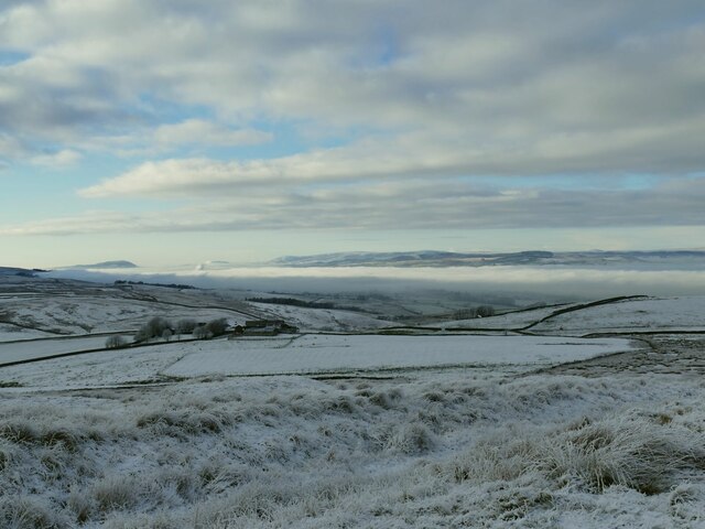
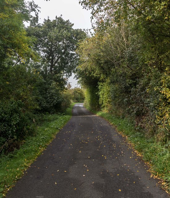
Ox Close Clough Images

Images are sourced within 2km of 53.897397/-2.2472833 or Grid Reference SD8344. Thanks to Geograph Open Source API. All images are credited.

Transmitter mast at Weets House Farm The location was presumably selected as it's on the shoulder of the hill between two valleys, to give coverage to both.
Transmitter mast at Weets House Farm
The location was presumably selected as it's on the shoulder of the hill between two valleys, to give coverage to both.
Weets House Farm The sign in the foreground indicates they have an alpaca herd. There was no sign of them on this occasion, but surely this is just the sort of weather the Andean creatures have evolved for?
Weets House Farm
The sign in the foreground indicates they have an alpaca herd. There was no sign of them on this occasion, but surely this is just the sort of weather the Andean creatures have evolved for?
Gate across Gisburn Old Road This marks the end of the road for motor vehicles coming from Blacko direction. beyond it the road becomes just the Pennine Bridleway. The sign beyond the wall indicates that the Pendle Way that shares the last section of tarmac road turns right here over the hill towards Barnoldswick.
Gate across Gisburn Old Road
This marks the end of the road for motor vehicles coming from Blacko direction. beyond it the road becomes just the Pennine Bridleway. The sign beyond the wall indicates that the Pendle Way that shares the last section of tarmac road turns right here over the hill towards Barnoldswick.
View across to Pendle from Weets House Pendle is 6km west-south-west from here, and the summit about 150m higher.
View across to Pendle from Weets House
Pendle is 6km west-south-west from here, and the summit about 150m higher.
Cold Weather House The farm in the middle distance is well named for this December view. Further ahead, a temperature inversion leaves Ribblesdale filled with low cloud.
Cold Weather House
The farm in the middle distance is well named for this December view. Further ahead, a temperature inversion leaves Ribblesdale filled with low cloud.
Frozen puddle on Weets Hill With Pendle in the distance. Location approximate.
Frozen puddle on Weets Hill
With Pendle in the distance. Location approximate.
Raven on Weets Hill triangulation pillar It could be a crow, but compared with the size of the standard pillar it's a big bird. I'm going with raven, as  they are not unknown in the Pennines. Photographed from a distance to catch it before it inevitably flew off as I approached.
Raven on Weets Hill triangulation pillar
It could be a crow, but compared with the size of the standard pillar it's a big bird. I'm going with raven, as they are not unknown in the Pennines. Photographed from a distance to catch it before it inevitably flew off as I approached.
Weets Hill triangulation pillar The pillar is close to the 397 metre summit of the hill, which is a good vantage point. Pendle is in the background of this view, with (I think) Longridge Fell peeking up out of the valley fog beyond.
Weets Hill triangulation pillar
The pillar is close to the 397 metre summit of the hill, which is a good vantage point. Pendle is in the background of this view, with (I think) Longridge Fell peeking up out of the valley fog beyond.
Weets Hill triangulation pillar - plaque I had to wipe the snow off this plaque to read it. It is on the north side of the base of the pillar <a href="https://www.geograph.org.uk/photo/7361560">SD8544 : Weets Hill triangulation pillar</a> and reads 'In loving memory of Garth Standen 7.11.43 - 21.9.15'.
Weets Hill triangulation pillar - plaque
I had to wipe the snow off this plaque to read it. It is on the north side of the base of the pillar SD8544 : Weets Hill triangulation pillar and reads 'In loving memory of Garth Standen 7.11.43 - 21.9.15'.
A seat above the clouds The bench is just below Weets Hill triangulation pillar. With a temperature inversion filling the valley with cloud, only the tops of the Yorkshire fells could be seen in this direction. <a href="https://www.geograph.org.uk/photo/5217981">SD8544 : A bench with a view</a> shows the view on a clear day.
A seat above the clouds
The bench is just below Weets Hill triangulation pillar. With a temperature inversion filling the valley with cloud, only the tops of the Yorkshire fells could be seen in this direction. SD8544 : A bench with a view shows the view on a clear day.
View north from Weets Hill With a temperature inversion filling the valley with cloud, only the tops of the Yorkshire fells, including Ingleborough and Pen-y-Ghent, could be seen in this direction.
View north from Weets Hill
With a temperature inversion filling the valley with cloud, only the tops of the Yorkshire fells, including Ingleborough and Pen-y-Ghent, could be seen in this direction.
Field gate on Whitehead Height Looking South West through field gate on Whitehead Height at Pendle Hill and Lower / Upper Black Moss reservoirs
Field gate on Whitehead Height
Looking South West through field gate on Whitehead Height at Pendle Hill and Lower / Upper Black Moss reservoirs
Top end of Helliwell Wood Looking West from Whitehead Height towards the top end of Helliwell Wood.
Top end of Helliwell Wood
Looking West from Whitehead Height towards the top end of Helliwell Wood.
Looking North from Wheathead Height Looking North to the next high spot from Wheathead Height. Ingleborough and Penny Ghent in the distance.
Looking North from Wheathead Height
Looking North to the next high spot from Wheathead Height. Ingleborough and Penny Ghent in the distance.
Stopper Lane
Stopper Lane
Wytha Road Junction of Wytha Road with Martin Top Lane.
Wytha Road
Junction of Wytha Road with Martin Top Lane.
Howgill Beck Fields above Howgill Beck seen from Wytha Road.
Howgill Beck
Fields above Howgill Beck seen from Wytha Road.
Wytha Road Wtha Road crossing Howgill Beck.
Wytha Road
Wtha Road crossing Howgill Beck.
Show me another place!

Ox Close Clough is located at Grid Ref: SD8344 (Lat: 53.897397, Lng: -2.2472833)

Division: West Riding

Administrative County: Lancashire

District: Ribble Valley

Police Authority: Lancashire

What 3 Words

///prongs.pony.eclipses. Near Barnoldswick, Lancashire

Related Wikis

Middop

Middop is a rural hamlet and civil parish in Lancashire, England. It is in Ribble Valley district. Middop is near the villages of Rimington and Gisburn...

Weets Hill

Weets Hill is a hill in the West Craven area of Pendle, Lancashire, England. It is 2+1⁄2 miles (4.0 km) south-west of the town of Barnoldswick and is 4...

Twiston

Twiston is a village and a civil parish in the Ribble Valley District, in the English county of Lancashire. It is near the town of Clitheroe and the village...

Rimington

Rimington is a rural village and civil parish in the Ribble Valley, Lancashire, England. The population of the civil parish was 382 at the 2001 Census...

Have you been to Ox Close Clough?

Leave your review of Ox Close Clough below (or comments, questions and feedback).