Dunter Cleugh

Valley in Berwickshire

Scotland

Dunter Cleugh

Approaching Harehead On the C class road that heads from the Whiteadder valley across the moors to the east coast near Dunbar. Just approaching the farm of Harehead.
Approaching Harehead Credit: Adam Ward

Dunter Cleugh is a picturesque valley located in the historic county of Berwickshire, Scotland. Situated in the Scottish Borders region, it is nestled between the Lammermuir Hills to the north and the Cheviot Hills to the south.

The valley is renowned for its stunning natural beauty, with rolling hills, lush green meadows, and meandering streams creating an idyllic countryside setting. It is a haven for nature enthusiasts and outdoor lovers, offering ample opportunities for hiking, cycling, and wildlife spotting.

Dunter Cleugh is also home to a diverse range of flora and fauna. The valley's fertile soil supports a variety of plant species, including wildflowers, heather, and mosses. This rich biodiversity attracts numerous bird species, such as buzzards, kestrels, and pheasants, making it a popular destination for birdwatchers.

Steeped in history, Dunter Cleugh boasts several archaeological and historical sites. The remains of ancient hill forts and burial mounds can be found within the valley, providing insights into the region's ancient inhabitants. Additionally, the nearby town of Duns, with its historic buildings and museums, offers further opportunities to delve into the area's past.

The peaceful and tranquil atmosphere of Dunter Cleugh, coupled with its stunning natural landscapes, make it a popular retreat for visitors seeking relaxation and a connection with nature. Whether exploring the valley's trails, admiring its panoramic views, or immersing oneself in its rich history, Dunter Cleugh is a truly captivating destination in the heart of Berwickshire.

If you have any feedback on the listing, please let us know in the comments section below.

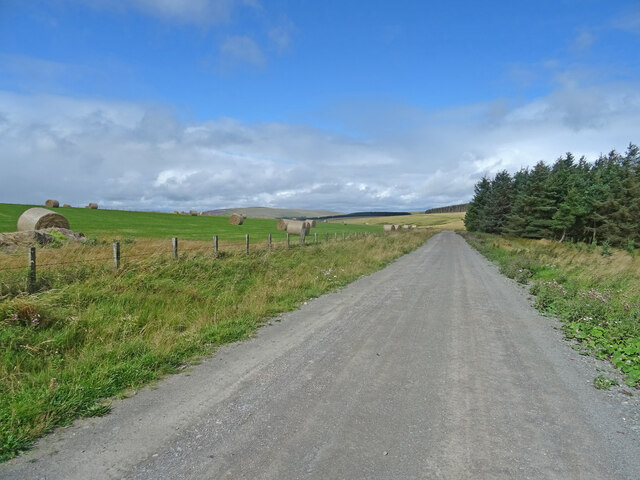
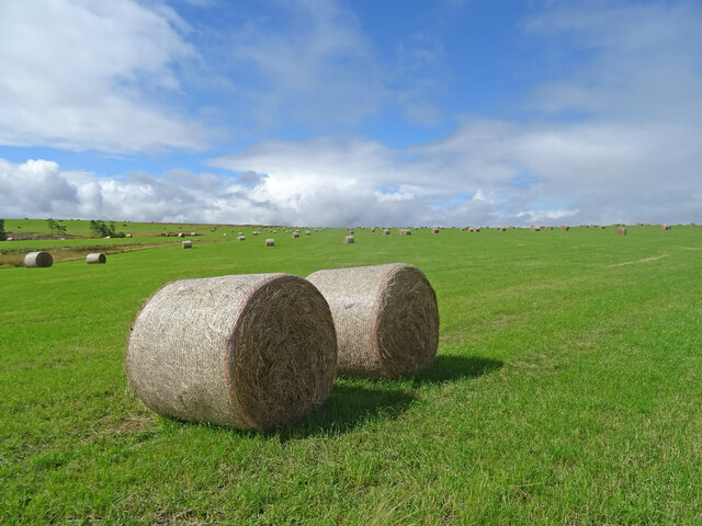
Dunter Cleugh Images

Images are sourced within 2km of 55.861637/-2.4620622 or Grid Reference NT7163. Thanks to Geograph Open Source API. All images are credited.

Approaching Harehead On the C class road that heads from the Whiteadder valley across the moors to the east coast near Dunbar. Just approaching the farm of Harehead.
Approaching Harehead
On the C class road that heads from the Whiteadder valley across the moors to the east coast near Dunbar. Just approaching the farm of Harehead.
On Blackcleugh Rig From the track near to the highpoint of Blackcleuch Rig, looking towards Monynut Edge and Aikengall Community Wind Farm. In between a newly harvested field with the straw already baled, while over the fence the forest has been felled and replanted, though you can't quite see the saplings in this picture.
On Blackcleugh Rig
From the track near to the highpoint of Blackcleuch Rig, looking towards Monynut Edge and Aikengall Community Wind Farm. In between a newly harvested field with the straw already baled, while over the fence the forest has been felled and replanted, though you can't quite see the saplings in this picture.
Track, Kirkgate Hill Track between forest and recently harvested field on the east side of Kirkgate Hill.  Hill in the distance is Spartleton.
Track, Kirkgate Hill
Track between forest and recently harvested field on the east side of Kirkgate Hill. Hill in the distance is Spartleton.
Bales, Kirkgate Hill Bales on the south-east side of Kirkgate Hill in the Scottish Borders near Cranshaws. Presumably for animal feed and have been brought here from elsewhere, given that the field does not look like its recently been harvested.
Bales, Kirkgate Hill
Bales on the south-east side of Kirkgate Hill in the Scottish Borders near Cranshaws. Presumably for animal feed and have been brought here from elsewhere, given that the field does not look like its recently been harvested.
Minor road and buildings at Nether Monynut Looking southward.
Minor road and buildings at Nether Monynut
Looking southward.
Nasty bit of road nr Moneynut Water the hill is part of Laughing Law
Nasty bit of road nr Moneynut Water
the hill is part of Laughing Law
Middle Monynut, Lammermuirs View over Skinner Burn.
Middle Monynut, Lammermuirs
View over Skinner Burn.
Borders Countryside Lovely view looking down the Monynut Water from slopes of Black Law in the Scottish Borders - it looks almost like a balmy spring or early summer's day, but in fact the wind chill must have been below freezing.
Borders Countryside
Lovely view looking down the Monynut Water from slopes of Black Law in the Scottish Borders - it looks almost like a balmy spring or early summer's day, but in fact the wind chill must have been below freezing.
Black Law A very green looking Black Law Scottish Borders looking west towards a 500 hectare conifer plantation.
Black Law
A very green looking Black Law Scottish Borders looking west towards a 500 hectare conifer plantation.
Looking towards Black Cleugh Scottish Borders farmland and conifer plantation.
Looking towards Black Cleugh
Scottish Borders farmland and conifer plantation.
Electric Fence - Borders Style All the gates hereabouts had these blue tubes to take the electric wire back up to the top of the fence. In the distance you can see Bentyhowe Wood.
Electric Fence - Borders Style
All the gates hereabouts had these blue tubes to take the electric wire back up to the top of the fence. In the distance you can see Bentyhowe Wood.
Bright Bales. These bales of hay could be seen from over 2km away with the afternoon sun on them. Near Bushelhill Farm, Scottish Borders.
Bright Bales.
These bales of hay could be seen from over 2km away with the afternoon sun on them. Near Bushelhill Farm, Scottish Borders.
Country Road Take me home - and it did too, but thankfully not to West Virginia, only Edinburgh!
Near Nether Monynut Farm, Scottish Borders on a lovely winter day.
Country Road
Take me home - and it did too, but thankfully not to West Virginia, only Edinburgh! Near Nether Monynut Farm, Scottish Borders on a lovely winter day.
Dunter Law The triangulation pillar and forest.  Felt a lot higher than 320m today.
Dunter Law
The triangulation pillar and forest. Felt a lot higher than 320m today.
Fence on Kirkgate Hill Farmland on a plateau. A track along the high ground here may be the Kirk Gate itself.
Fence on Kirkgate Hill
Farmland on a plateau. A track along the high ground here may be the Kirk Gate itself.
Pines, High Strip High Strip is as it says on the tin, a stripwood, high above the Whiteadder water. The smudges in the sky are woods on a hillside the other side of the glen.
Pines, High Strip
High Strip is as it says on the tin, a stripwood, high above the Whiteadder water. The smudges in the sky are woods on a hillside the other side of the glen.
Smiddyhill Burn View? down from Kirkgate Hill at the start of a lengthy period of heavy snow.
Smiddyhill Burn
View? down from Kirkgate Hill at the start of a lengthy period of heavy snow.
Kirkgate Hill View along the hill, with several fences. The one running away from the point of view is an electric fence, no problems crossing it today though as the stock are all down in the glen, or wintering away from the hills.
Kirkgate Hill
View along the hill, with several fences. The one running away from the point of view is an electric fence, no problems crossing it today though as the stock are all down in the glen, or wintering away from the hills.
Show me another place!

Dunter Cleugh is located at Grid Ref: NT7163 (Lat: 55.861637, Lng: -2.4620622)

Unitary Authority: The Scottish Borders

Police Authority: The Lothians and Scottish Borders

What 3 Words

///discussed.aced.swarm. Near Duns, Scottish Borders

Related Wikis

Bothwell Water

The Bothwell Water is a river in the Scottish Borders area of Scotland. It rises in the Lammermuir Hills near Caldercleugh and continues past the Upper...

Cranshaws Castle

Cranshaws Castle or Cranshaws Tower is a privately owned 15th-century pele situated by the village of Cranshaws in Berwickshire, Scotland. The building...

Cranshaws

Cranshaws is a village on the B6355 road, near Duns, in the Scottish Borders area of Scotland, in the former Berwickshire. Of Cranshaws Castle only the...

Dye Water

The Dye Water (Scottish Gaelic: Uisge DhĂ idh) is a river in the Lammermuir Hills in the Scottish Borders area of Scotland. It rises in the Hope Hills,...

Have you been to Dunter Cleugh?

Leave your review of Dunter Cleugh below (or comments, questions and feedback).