Letham Den

Valley in Angus

Scotland

Letham Den

Barn, East Mains of Dunnichen
Barn, East Mains of Dunnichen Credit: JThomas

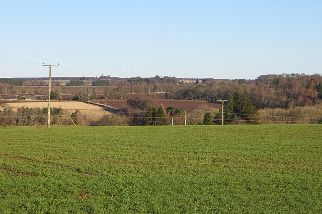
Letham Den, located in Angus, Scotland, is a picturesque valley that offers a tranquil and scenic escape for visitors. Situated near the village of Letham, the den is a designated local nature reserve and a popular spot for nature enthusiasts and walkers alike.

The den is characterized by its lush greenery, diverse wildlife, and meandering footpaths. It is home to a variety of trees, including oak, ash, and beech, which create a beautiful canopy overhead. The dense vegetation provides a habitat for a wide range of bird species, such as woodpeckers, thrushes, and owls, making it a haven for birdwatchers.

The den is crisscrossed by several well-maintained trails, allowing visitors to explore the area at their own pace. The paths wind their way through the valley, offering stunning views of the surrounding countryside and the meandering Letham Burn, a small river that runs through the den. There are also several wooden bridges that add to the idyllic atmosphere of the place.

In addition to its natural beauty, Letham Den has historical significance. The remains of an ancient fort, known as Letham Hill Fort, can be found within the den's boundaries. This archaeological site dates back to the Iron Age and provides insight into the area's rich past.

Overall, Letham Den, Angus, offers a wonderful opportunity to connect with nature, enjoy a peaceful stroll, and discover the region's history. Whether you are seeking outdoor adventures or a serene retreat, this hidden gem in Angus is sure to captivate visitors of all ages.

If you have any feedback on the listing, please let us know in the comments section below.

Letham Den Images

Images are sourced within 2km of 56.627732/-2.7600246 or Grid Reference NO5348. Thanks to Geograph Open Source API. All images are credited.

Barn, East Mains of Dunnichen
Potato crop in flower, Drummietermont
Cereal crop towards Drummietermont
Minor road near Drummietermont Towards the A932.
Minor road near Drummietermont
Towards the A932.
Potato crop, Backhow
Minor road, Backhow Towards the A932.
Minor road, Backhow
Towards the A932.
The Girdlestane A roadside surprise with an illegible signboard behind it. The rock is smooth and grey which would indicate an erratic transported from elsewhere by ice. Then one notices a faint circle inscribed in the stone and also some prehistoric cup marks, so obviously a stone of some significance. In later times it has been used as a parish boundary marker, and one story about its arrival here concerns not a glacier, but a witch who was carrying the stone on her back when the ties broke and the stone fell here. Not quite sure why any witch, strong or otherwise, would want to carry this.
The Girdlestane
A roadside surprise with an illegible signboard behind it. The rock is smooth and grey which would indicate an erratic transported from elsewhere by ice. Then one notices a faint circle inscribed in the stone and also some prehistoric cup marks, so obviously a stone of some significance. In later times it has been used as a parish boundary marker, and one story about its arrival here concerns not a glacier, but a witch who was carrying the stone on her back when the ties broke and the stone fell here. Not quite sure why any witch, strong or otherwise, would want to carry this.
Kirkden Graveyard Kirkden graveyard situated on the edge of the village of Letham contains graves from as early as 1739 and the bell mounted on the wall belongs to the kirk which was demolished in 1952.
Kirkden Graveyard
Kirkden graveyard situated on the edge of the village of Letham contains graves from as early as 1739 and the bell mounted on the wall belongs to the kirk which was demolished in 1952.
Potato crop and hedgerow near Finnieston
Farm road towards Newmill
Woodland, Milldens
Woodland, Milldens
A932 towards Friockheim
Woodland, Moore's Hill
A932 towards Forfar
A932 towards Forfar
Road junction
Road junction
Road to Balgavies and Newmill A farm road signposted as a path.
Road to Balgavies and Newmill
A farm road signposted as a path.
Arable land, Balgavies
Diel's Lappie Diel's Lappie is a flooded kettlehole next to an esker just north of the Arbroath to Forfar road.
Diel's Lappie
Diel's Lappie is a flooded kettlehole next to an esker just north of the Arbroath to Forfar road.
Show me another place!

Letham Den is located at Grid Ref: NO5348 (Lat: 56.627732, Lng: -2.7600246)

Unitary Authority: Angus

Police Authority: Tayside

What 3 Words

///nuggets.albums.imposes. Near Letham, Angus

Related Wikis

Letham, Angus

Letham (Scots pronunciation: [ˈlɛθəm]) is a village in Angus, Scotland. Letham is the largest village in Angus, with a population of nearly 2,000. Situated...

Auldbar Road railway station

Auldbar Road railway station was located near the town of Guthrie in the Scottish county of Angus. == History == Opened by the Arbroath and Forfar Railway...

Bowriefauld

Bowriefauld is a village in Angus, Scotland.

Dunnichen

Dunnichen (Scots pronunciation: [dəˈnɪxən]; Scottish Gaelic: Dùn Eachain) is a small village in Angus, Scotland, situated between Letham and Forfar. It...

Guthrie Castle

Guthrie Castle is a castle and country house in Angus, Scotland. It is located in the village of Guthrie, 10 kilometres (6.2 mi) east of Forfar, and 29...
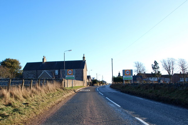
Craichie

Craichie (Scots pronunciation: [ˈkrexe]) is a hamlet in the parish of Dunnichen, Angus, Scotland. Craichie is three miles south-east of Forfar and two...

Guthrie railway station

Guthrie railway station served the village of Guthrie, Angus, Scotland from 1838 to 1955 on the Arbroath and Forfar Railway. == History == The station...

Guthrie, Angus

Guthrie is a village in Angus, Scotland, roughly at the centre point of the towns of Arbroath, Brechin and Forfar. The principal building in the village...

Nearby Amenities

Located within 500m of 56.627732,-2.7600246
Bus Stop
Police Station
Local Ref: at
Naptan AtcoCode: 6490IM172
Naptan Bearing: E
Naptan CommonName: Police Station
Naptan Indicator: opp Square
Naptan Landmark: Police Station
Naptan NaptanCode: 26424863
Naptan Street: East Hemming Street
Naptan Verified: no
Source: naptan_import
Lat/Long: 56.6292089/-2.7668971
Bus Stop
Police Station
Local Ref: opp
Naptan AtcoCode: 6490IM176
Naptan Bearing: W
Naptan CommonName: opp Police Station
Naptan Indicator: at Square
Naptan Landmark: Police Station
Naptan NaptanCode: 26424864
Naptan Street: East Hemming Street
Naptan Verified: no
Source: naptan_import
Lat/Long: 56.6291522/-2.7665664
Bus Stop
Denholm Gardens
Local Ref: nr
Naptan AtcoCode: 6490IM182
Naptan Bearing: SE
Naptan BusStopType: CUS
Naptan CommonName: East Den Brae
Naptan Indicator: towards Arbroath
Naptan Landmark: East Den Brae
Naptan NaptanCode: 26424859
Naptan Street: East Den Brae
Naptan Verified: no
Source: naptan_import
Lat/Long: 56.6292759/-2.7625102
Bus Stop
Denholm Gardens
Local Ref: opp
Naptan AtcoCode: 6490IM183
Naptan Bearing: NW
Naptan CommonName: East Den Brae
Naptan Indicator: towards Forfar
Naptan Landmark: East Den Brae
Naptan NaptanCode: 26424862
Naptan Street: East Den Brae
Naptan Verified: no
Source: naptan_import
Lat/Long: 56.6291756/-2.7627527
Bus Stop
Trumperton Road End
Local Ref: opp
Naptan AtcoCode: 6490IM400
Naptan Bearing: NE
Naptan BusStopType: CUS
Naptan CommonName: Trumperton Road End
Naptan Indicator: opp Road End
Naptan Landmark: Trumperton Road End
Naptan NaptanCode: 26425746
Naptan Street: Trumperton Road End
Naptan Verified: no
Source: naptan_import
Lat/Long: 56.6309968/-2.7570059
Bus Stop
Trumperton Road End
Local Ref: at
Naptan AtcoCode: 6490IM441
Naptan Bearing: SW
Naptan BusStopType: CUS
Naptan CommonName: Trumperton Road End
Naptan Indicator: at Road End
Naptan Landmark: Trumperton Road End
Naptan NaptanCode: 26425745
Naptan Street: Trumperton Road End
Naptan Verified: no
Source: naptan_import
Lat/Long: 56.631396/-2.7566519
Power: pole
Lat/Long: 56.6264731/-2.7530991
Power: pole
Lat/Long: 56.6243971/-2.7558153
Power: pole
Lat/Long: 56.6255056/-2.7543524
Turning Circle
Lat/Long: 56.6284028/-2.7672752
Arbrie Hill
Ele: 95
Natural: hill
Place: locality
Lat/Long: 56.6250754/-2.7633683
Central Motors Letham
Addr City: Forfar
Addr Housenumber: 5
Addr Postcode: DD8 2PT
Addr Street: East Hemming Street
Addr Village: Letham
Opening Hours: Mo-Fr 08:00-18:00, Sa 09:00-12:00
Shop: car_repair
Lat/Long: 56.6288778/-2.7678457
Leisure: picnic_table
Lat/Long: 56.6270485/-2.7627341
Historic: memorial
Memorial: war_memorial
Lat/Long: 56.6260021/-2.7649365
Kirkden
Place: isolated_dwelling
Lat/Long: 56.6259658/-2.7651735
Letham
Traffic Sign: city_limit
Traffic Sign Direction: backward
Lat/Long: 56.6286598/-2.7599057
Leisure: picnic_table
Lat/Long: 56.6268426/-2.7635328
Leisure: picnic_table
Lat/Long: 56.6269518/-2.763337
Hogg's Well
Natural: spring
Lat/Long: 56.6291056/-2.7634529
Trumperton
Alt Name: East Trumperton
Place: isolated_dwelling
Lat/Long: 56.6307416/-2.7557984
Macphersons Electrical Services Ltd
Addr City: Forfar
Addr Housename: Bridgend Farmhouse
Addr Street: The Den
Addr Village: Letham
Craft: electrician
Lat/Long: 56.6265331/-2.7628623
Power: pole
Lat/Long: 56.6238269/-2.7570059
Power: pole
Lat/Long: 56.624169/-2.7584258
Power: pole
Lat/Long: 56.6244501/-2.7595902
Power: pole
Lat/Long: 56.624771/-2.7609401
Power: pole
Lat/Long: 56.6252337/-2.7617427
Power: pole
Lat/Long: 56.6256292/-2.7623803
Power: pole
Lat/Long: 56.6256952/-2.762516
Power: pole
Lat/Long: 56.6260347/-2.7631265
Power: pole
Lat/Long: 56.6263594/-2.7636917
Power: pole
Lat/Long: 56.6264141/-2.7637867
Power: pole
Lat/Long: 56.6267922/-2.7644288
Power: pole
Lat/Long: 56.6265857/-2.7649082
Power: pole
Lat/Long: 56.6263196/-2.7655435
Power: pole
Lat/Long: 56.6260484/-2.7662082
Power: pole
Lat/Long: 56.6311997/-2.7570396
Power: pole
Lat/Long: 56.6307305/-2.7566988
Power: pole
Lat/Long: 56.630052/-2.7562179
Power: pole
Lat/Long: 56.6296714/-2.7569664
Power: pole
Lat/Long: 56.6291689/-2.7579699
Power: pole
Lat/Long: 56.6287134/-2.7588689
Power: pole
Lat/Long: 56.629737/-2.7553816
Bridgend
Place: locality
Lat/Long: 56.6265203/-2.7628725
The data included in this document is from www.openstreetmap.org. The data is made available under ODbL.

Have you been to Letham Den?

Leave your review of Letham Den below (or comments, questions and feedback).