Black Cleuch

Valley in Roxburghshire

Scotland

Black Cleuch

Minor road near to the Hizzy Memorial Cairn Looking north-eastward.
Minor road near to the Hizzy Memorial Cairn Credit: Peter Wood

Black Cleuch is a picturesque valley located in the region of Roxburghshire, Scotland. Nestled in the southern uplands, this tranquil area is renowned for its stunning natural beauty and rich historical significance. The valley is situated about 8 miles northwest of Hawick, the largest town in the area.

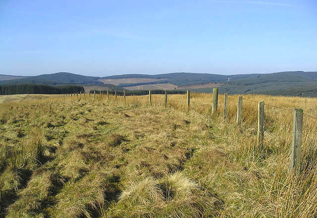
The landscape of Black Cleuch is dominated by rolling hills, lush green meadows, and a meandering river that runs through the valley. The surrounding hills offer breathtaking views of the countryside, making it a popular destination for nature enthusiasts and hikers. The valley is also home to a variety of wildlife, including red deer, pheasants, and buzzards.

Black Cleuch boasts a rich history dating back to the prehistoric era. Archaeological expeditions have uncovered ancient settlements and burial sites in the area, providing valuable insights into the region's past. The valley was also an important site during the Border Reivers period, when it served as a hiding place for the notorious raiders who plagued the Anglo-Scottish border.

Today, Black Cleuch retains its unspoiled charm, attracting visitors from near and far who seek solace in its tranquil surroundings. The valley offers several walking trails, allowing visitors to explore its natural wonders at their own pace. Whether it's admiring the vibrant wildflowers in spring or witnessing the stunning autumn foliage, Black Cleuch offers a unique and immersive experience for those seeking a connection with nature.

If you have any feedback on the listing, please let us know in the comments section below.

Black Cleuch Images

Images are sourced within 2km of 55.318064/-2.9833427 or Grid Reference NT3703. Thanks to Geograph Open Source API. All images are credited.

Minor road near to the Hizzy Memorial Cairn Looking north-eastward.
Minor road near to the Hizzy Memorial Cairn
Looking north-eastward.
Blackcleuch This house stands by the River Teviot in a remote location.
Blackcleuch
This house stands by the River Teviot in a remote location.
Moorland Landscape The hill in the background is Blackcleuch Rig.
Moorland Landscape
The hill in the background is Blackcleuch Rig.
The Hizzy Cairn Beside a minor road near Teviothead and dedicated to Steve Hislop who was killed near this spot.
A plaque on the small enclosure fence reads:-

'Hizzy'
This cairn was built by a
few friends of Steve Hislop,
British Superbike Champion,
who was tragically killed in a
helicopter accident near this site,
on July 30th 2003.

Kind permission was granted
by His Grace
The Duke of Buccleuch.
The Hizzy Cairn
Beside a minor road near Teviothead and dedicated to Steve Hislop who was killed near this spot. A plaque on the small enclosure fence reads:- 'Hizzy' This cairn was built by a few friends of Steve Hislop, British Superbike Champion, who was tragically killed in a helicopter accident near this site, on July 30th 2003. Kind permission was granted by His Grace The Duke of Buccleuch.
A country road A narrow road with passing places that runs from Merrylaw at the edge of Craik Forest to Teviothead by the A7.
A country road
A narrow road with passing places that runs from Merrylaw at the edge of Craik Forest to Teviothead by the A7.
The road to Lymiecleuch Farm
A drystone dyke on Blackcleuch Rig
Blackcleuch Rig A large rough grazing area with a fence leading to Rowantree Hill.
Blackcleuch Rig
A large rough grazing area with a fence leading to Rowantree Hill.
Rowantree Hill The unmarked summit of Rowantree Hill at 372m with Craik Forest in the background.
Rowantree Hill
The unmarked summit of Rowantree Hill at 372m with Craik Forest in the background.
Hislop Farm building and houses at Hislop viewed from Blackcleuch Rig.
Hislop
Farm building and houses at Hislop viewed from Blackcleuch Rig.
Thornycleuch Knowe Rough grazing by Craik Forest and the summit of Byehass Fell in the distance.
Thornycleuch Knowe
Rough grazing by Craik Forest and the summit of Byehass Fell in the distance.
Upland grazing Rough grazing for hill sheep to the southeast of Byehass Fell and the edge of Craik Forest on the left.
Upland grazing
Rough grazing for hill sheep to the southeast of Byehass Fell and the edge of Craik Forest on the left.
Fauld Burn Looking down to the Fauld Burn with forestry behind on Haregrain Edge.
Fauld Burn
Looking down to the Fauld Burn with forestry behind on Haregrain Edge.
Peat Rig A rough grazing hillside with a flock of sheep in the distance.
Peat Rig
A rough grazing hillside with a flock of sheep in the distance.
Sheepfold Viewed from a track near Hislop Farm.
Sheepfold
Viewed from a track near Hislop Farm.
Fauld Burn To the west-northwest of Hislop.
Fauld Burn
To the west-northwest of Hislop.
Border Hill Country Approaching Blackcleuch Rig from the Tanlaw Naze direction. A few sheep are in the distance on the left in this large rough grazing area.
Border Hill Country
Approaching Blackcleuch Rig from the Tanlaw Naze direction. A few sheep are in the distance on the left in this large rough grazing area.
Limiecleuch Burn Viewed from Caerlan Rig.
Limiecleuch Burn
Viewed from Caerlan Rig.
Show me another place!

Black Cleuch is located at Grid Ref: NT3703 (Lat: 55.318064, Lng: -2.9833427)

Unitary Authority: The Scottish Borders

Police Authority: The Lothians and Scottish Borders

What 3 Words

///verve.thigh.entitle. Near Teviothead, Scottish Borders

Related Wikis

River Teviot

The River Teviot (; Scottish Gaelic: Abhainn Tìbhiot), or Teviot Water, is a river of the Scottish Borders area of Scotland, and is the largest tributary...

Caerlanrig

Caerlanrig - also spelled 'Carlenrig' - (Gaelic: Cathair Lannraig) is a hamlet in the parish of Cavers, Borders, Scotland, lying on the River Teviot, 6...

Falnash

Falnash (Scots: Fawenesh) is a village in the Scottish Borders of Scotland. It is near Teviothead, in the former Roxburghshire, and in the parish of Teviothead...

Teviothead

Teviothead (Scottish Gaelic: Ceann Tìbhiot) is a small village and civil parish in Teviotdale in the Scottish Borders, known locally as Teviotheid. It...

Craik, Scottish Borders

Craik is a hamlet in Craik Forest, by the Airhouse Burn in the Scottish Borders area of Scotland, close to Roberton, Scottish Borders (grid reference NT348084...

Craik Forest

Craik Forest is a forest near Hawick in the Scottish Borders area of Scotland, and managed by the Forestry Commission. It is adjoined to the south-west...

Cauldcleuch Head

Cauldcleuch Head is a hill in an unnamed range of Roxburghshire hills north of Langholm, part of the Southern Uplands of Scotland. The highest hill in...

Unthank, Dumfries and Galloway

Unthank is a village in Dumfries and Galloway, Scotland. == References == The geographic coordinates are from the Ordnance Survey.

Have you been to Black Cleuch?

Leave your review of Black Cleuch below (or comments, questions and feedback).