The Dean

Valley in Lanarkshire

Scotland

The Dean

Medwin Water at Roseburgh Bridge The Medwin Water is a tributary of the River Clyde, which is meets a short distance to the west at The Meetings.  Roseburgh Bridge carries Biggar Road over the Medwin and can be seen to the left of shot.

This photograph was taken during the Coronavirus (COVID-19) pandemic of 2020/21.
Medwin Water at Roseburgh Bridge Credit: James T M Towill

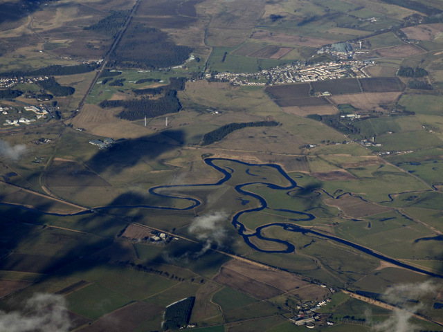
The Dean, located in Lanarkshire, Scotland, is a picturesque valley known for its stunning natural beauty and rich history. Situated in the southern part of the country, The Dean offers visitors a tranquil retreat from the hustle and bustle of city life.

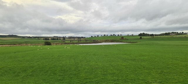
The valley is characterized by its rolling hills, lush green landscapes, and meandering streams, making it a haven for outdoor enthusiasts and nature lovers. Hiking and walking trails are abundant, providing opportunities to explore the valley's diverse flora and fauna. The Dean is particularly famous for its vibrant wildflower displays during the spring and summer months.

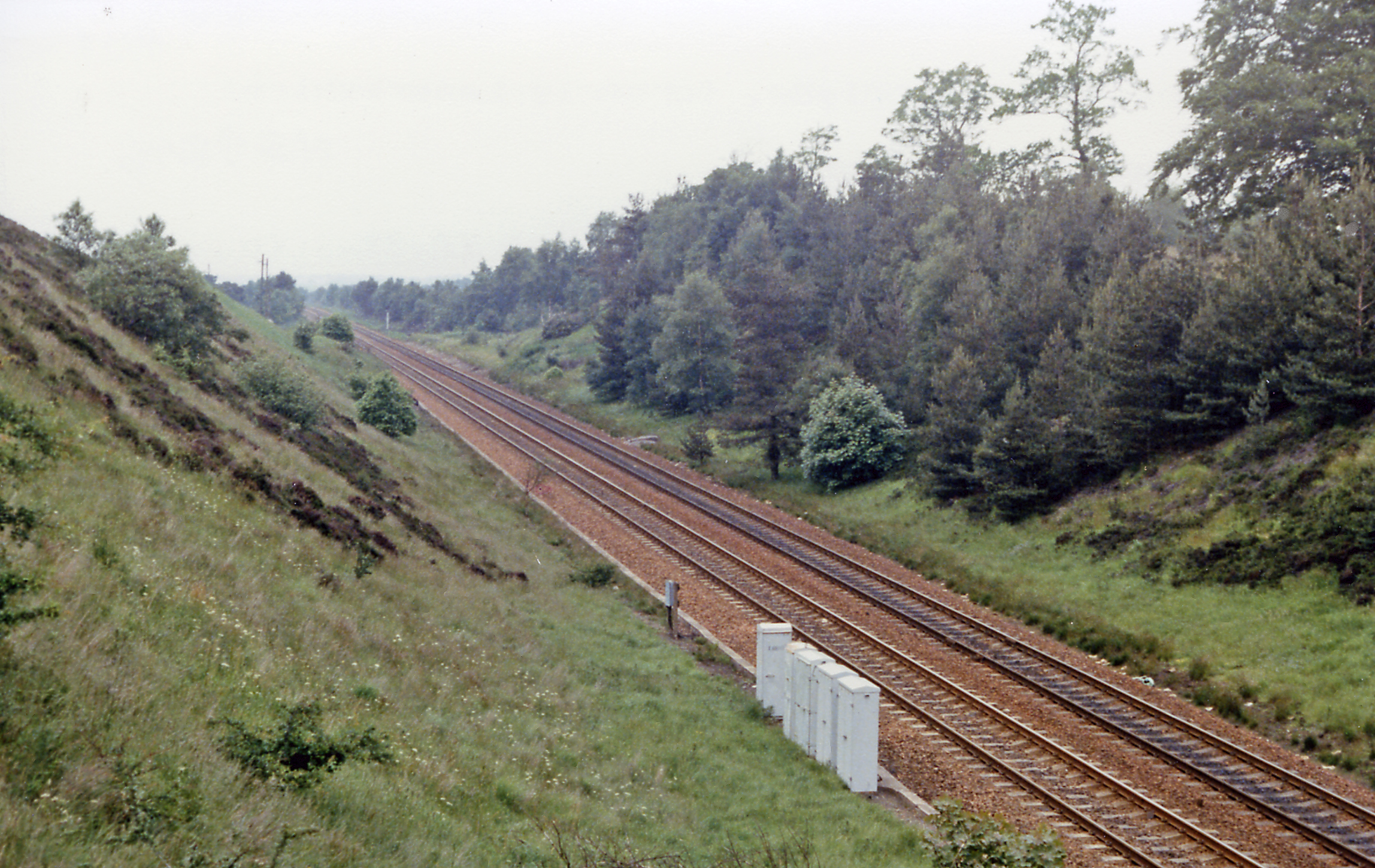
Historically, The Dean played a significant role in the region's industrial development. The valley was once a bustling coal mining area, and remnants of this industrial past can still be seen in the form of old mine shafts and disused railway lines. The mining heritage has left a lasting impact on the local community and is an essential part of the area's identity.

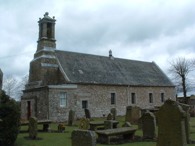
In addition to its natural beauty and industrial history, The Dean boasts several charming villages and hamlets. These settlements feature traditional stone cottages, quaint shops, and friendly locals, offering visitors a glimpse into rural Scottish life. The community takes pride in preserving its cultural heritage, and various events and festivals are organized throughout the year to celebrate the local traditions.

Overall, The Dean, Lanarkshire, is a hidden gem that combines stunning landscapes, a rich industrial past, and a warm community spirit. Whether you are seeking outdoor adventures, historical exploration, or a peaceful getaway, The Dean has something to offer for everyone.

If you have any feedback on the listing, please let us know in the comments section below.

The Dean Images

Images are sourced within 2km of 55.689356/-3.6363616 or Grid Reference NS9745. Thanks to Geograph Open Source API. All images are credited.

Medwin Water at Roseburgh Bridge The Medwin Water is a tributary of the River Clyde, which is meets a short distance to the west at The Meetings.  Roseburgh Bridge carries Biggar Road over the Medwin and can be seen to the left of shot.

This photograph was taken during the Coronavirus (COVID-19) pandemic of 2020/21.
Medwin Water at Roseburgh Bridge
The Medwin Water is a tributary of the River Clyde, which is meets a short distance to the west at The Meetings. Roseburgh Bridge carries Biggar Road over the Medwin and can be seen to the left of shot. This photograph was taken during the Coronavirus (COVID-19) pandemic of 2020/21.
Clyde Bridge and associated structures Clyde Bridge carries Pettinain Road over the River Clyde just south of Carstairs Junction.  Built in 1912, it is an example of early use of pre-cast reinforced concrete in bridge construction.  In this view, flood tunnels in the southern approach embankment can also be noted.

Crossing the Clyde – Clyde and other bridges from Elvanfoot to Lanark
by Tam Ward 2016 (Biggar Archaeology Group) <span class="nowrap"><a title="http://217.199.187.196/biggararchaeology.org.uk/wp-content/uploads/2016/12/BAG-Crossing-the-Clyde-Report_low.pdf" rel="nofollow ugc noopener" href="http://217.199.187.196/biggararchaeology.org.uk/wp-content/uploads/2016/12/BAG-Crossing-the-Clyde-Report_low.pdf">Link</a><img style="margin-left:2px;" alt="External link" title="External link - shift click to open in new window" src="https://s1.geograph.org.uk/img/external.png" width="10" height="10"/></span> calls this bridge Lampits Ferry Bridge, but Clyde Bridge seems to be used more frequently, and is the name used by South Lanarkshire Council, for example.  Ward notes: 'The bridge on this calm stretch of the river has nothing to commend it for appearance as it is rather unattractive, although interestingly being partially made from pre cast concrete. The very narrow bridge crosses the Clyde on three sets of double circular pillars, each pair is connected by a cross lattice also of concrete, these are set in line with the river but are askew of the road above, which crosses at an angle. Clearly the planners at this time were not preparing for future levels of traffic, perhaps taking the view that the advent of motorised vehicles was just a fad? However they did take into consideration the flooding Clyde, and like Wolf Clyde above, additional flood tunnels were built under the approach road.'

The bridge was closed to traffic over 2t as far back as October 1955 <span class="nowrap"><a title="https://hansard.parliament.uk/Commons/1957-03-27/debates/cf82a5ac-6b4c-4efa-9efb-f0f86cc3b57d/ClydeBridgeCarstairs" rel="nofollow ugc noopener" href="https://hansard.parliament.uk/Commons/1957-03-27/debates/cf82a5ac-6b4c-4efa-9efb-f0f86cc3b57d/ClydeBridgeCarstairs">Link</a><img style="margin-left:2px;" alt="External link" title="External link - shift click to open in new window" src="https://s1.geograph.org.uk/img/external.png" width="10" height="10"/></span> and most recently, in August 2018, it was closed completely to traffic on safety grounds.  

Work on a replacement bridge, costing in the region of £3.8M, is due to begin later in 2021 and will entail a new bridge being constructed as noted in the Public Contracts Scotland tendering notice <span class="nowrap"><a title="https://www.publiccontractsscotland.gov.uk/search/show/search_view.aspx?ID=FEB407097" rel="nofollow ugc noopener" href="https://www.publiccontractsscotland.gov.uk/search/show/search_view.aspx?ID=FEB407097">Link</a><img style="margin-left:2px;" alt="External link" title="External link - shift click to open in new window" src="https://s1.geograph.org.uk/img/external.png" width="10" height="10"/></span> : 'South Lanarkshire Council are proceeding with the construction of a 90-metre single span proprietary steel bridge to replace the existing reinforced concrete bridge structure, subject to the Council acquiring the land required for the project as set out below. The proposed structure includes a 4.2m wide carriageway with an additional footway of minimum width 1.05m. The new structure will be constructed off-line of the existing bridge. The proposed carriageway on approach to the structure will follow a new alignment and will include new approach roads to the north and south which will tie into the existing C29 Pettinain Road.  The proprietary bridge will be supported on reinforced concrete abutments which, in turn, will be supported by piled foundations. On the north approach the structure will also include wing walls which will not be connected to the abutment and will behave as retaining walls. On the south approach the structure will include wing walls which will not be connected to the abutment and will behave as retaining walls and a cattle creep structure.  The superstructure is proposed to be launched from the south abutment and a launching area for this purpose will be built.  In addition to this the design also includes for the replacement of a cattle creep structure located approximately 350m south of Clyde Bridge and the infilling of a culvert located approximately 270m south of Clyde Bridge.'

This photograph was taken during the Coronavirus (COVID-19) pandemic of 2020/21.
Clyde Bridge and associated structures
Clyde Bridge carries Pettinain Road over the River Clyde just south of Carstairs Junction. Built in 1912, it is an example of early use of pre-cast reinforced concrete in bridge construction. In this view, flood tunnels in the southern approach embankment can also be noted. Crossing the Clyde – Clyde and other bridges from Elvanfoot to Lanark by Tam Ward 2016 (Biggar Archaeology Group) LinkExternal link calls this bridge Lampits Ferry Bridge, but Clyde Bridge seems to be used more frequently, and is the name used by South Lanarkshire Council, for example. Ward notes: 'The bridge on this calm stretch of the river has nothing to commend it for appearance as it is rather unattractive, although interestingly being partially made from pre cast concrete. The very narrow bridge crosses the Clyde on three sets of double circular pillars, each pair is connected by a cross lattice also of concrete, these are set in line with the river but are askew of the road above, which crosses at an angle. Clearly the planners at this time were not preparing for future levels of traffic, perhaps taking the view that the advent of motorised vehicles was just a fad? However they did take into consideration the flooding Clyde, and like Wolf Clyde above, additional flood tunnels were built under the approach road.' The bridge was closed to traffic over 2t as far back as October 1955 LinkExternal link and most recently, in August 2018, it was closed completely to traffic on safety grounds. Work on a replacement bridge, costing in the region of £3.8M, is due to begin later in 2021 and will entail a new bridge being constructed as noted in the Public Contracts Scotland tendering notice LinkExternal link : 'South Lanarkshire Council are proceeding with the construction of a 90-metre single span proprietary steel bridge to replace the existing reinforced concrete bridge structure, subject to the Council acquiring the land required for the project as set out below. The proposed structure includes a 4.2m wide carriageway with an additional footway of minimum width 1.05m. The new structure will be constructed off-line of the existing bridge. The proposed carriageway on approach to the structure will follow a new alignment and will include new approach roads to the north and south which will tie into the existing C29 Pettinain Road. The proprietary bridge will be supported on reinforced concrete abutments which, in turn, will be supported by piled foundations. On the north approach the structure will also include wing walls which will not be connected to the abutment and will behave as retaining walls. On the south approach the structure will include wing walls which will not be connected to the abutment and will behave as retaining walls and a cattle creep structure. The superstructure is proposed to be launched from the south abutment and a launching area for this purpose will be built. In addition to this the design also includes for the replacement of a cattle creep structure located approximately 350m south of Clyde Bridge and the infilling of a culvert located approximately 270m south of Clyde Bridge.' This photograph was taken during the Coronavirus (COVID-19) pandemic of 2020/21.
Flood tunnels under the southern approach to Clyde Bridge Looking through the flood tunnels to more grazing land east of Pettinain Road.

This photograph was taken during the Coronavirus (COVID-19) pandemic of 2020/21.
Flood tunnels under the southern approach to Clyde Bridge
Looking through the flood tunnels to more grazing land east of Pettinain Road. This photograph was taken during the Coronavirus (COVID-19) pandemic of 2020/21.
The River Clyde flowing under Clyde Bridge Low summer water levels are evident at this spot on the Clyde floodplain near Carstairs Junction.  And yes, that concrete pier in the foreground does appear slightly out of alignment - perhaps a good job the bridge is closed!

This photograph was taken during the Coronavirus (COVID-19) pandemic of 2020/21.
The River Clyde flowing under Clyde Bridge
Low summer water levels are evident at this spot on the Clyde floodplain near Carstairs Junction. And yes, that concrete pier in the foreground does appear slightly out of alignment - perhaps a good job the bridge is closed! This photograph was taken during the Coronavirus (COVID-19) pandemic of 2020/21.
The upstream side of Clyde Bridge A view of Clyde Bridge from the upstream (east) side, showing the cross-bracing of the bridge piers.

This photograph was taken during the Coronavirus (COVID-19) pandemic of 2020/21.
The upstream side of Clyde Bridge
A view of Clyde Bridge from the upstream (east) side, showing the cross-bracing of the bridge piers. This photograph was taken during the Coronavirus (COVID-19) pandemic of 2020/21.
Under Clyde Bridge A view looking north under Clyde Bridge showing facets of the superstructure and its deterioration.

This photograph was taken during the Coronavirus (COVID-19) pandemic of 2020/21.
Under Clyde Bridge
A view looking north under Clyde Bridge showing facets of the superstructure and its deterioration. This photograph was taken during the Coronavirus (COVID-19) pandemic of 2020/21.
A 'Tell-Tale' on Clyde Bridge Produced by Avonguard, these products are used to measure crack movement.  

The manufacturer states <span class="nowrap"><a title="https://www.avongard.com/products/category/1/tell-tales/P-00001/standard-tell-tale" rel="nofollow ugc noopener" href="https://www.avongard.com/products/category/1/tell-tales/P-00001/standard-tell-tale">Link</a><img style="margin-left:2px;" alt="External link" title="External link - shift click to open in new window" src="https://s1.geograph.org.uk/img/external.png" width="10" height="10"/></span> : 'Avongard Tell-Tales are precision gauges that consist of two plates which overlap for a part of their length. The bottom plate is calibrated in milli-metres and the top plate is transparent and marked with a hairline cursor in the form of a cross.  The Tell-Tale is fixed across the crack using screws and plugs and/or adhesive.  The two pegs are removed. As the crack opens, or closes, the cursor moves relative to the calibration scale. The opening or closing of the crack is then recorded on the crack record sheet supplied.'

There are at least a dozen 'Tell-Tales' in use on Clyde Bridge, some of which have been vandalised.

This photograph was taken during the Coronavirus (COVID-19) pandemic of 2020/21.
A 'Tell-Tale' on Clyde Bridge
Produced by Avonguard, these products are used to measure crack movement. The manufacturer states LinkExternal link : 'Avongard Tell-Tales are precision gauges that consist of two plates which overlap for a part of their length. The bottom plate is calibrated in milli-metres and the top plate is transparent and marked with a hairline cursor in the form of a cross. The Tell-Tale is fixed across the crack using screws and plugs and/or adhesive. The two pegs are removed. As the crack opens, or closes, the cursor moves relative to the calibration scale. The opening or closing of the crack is then recorded on the crack record sheet supplied.' There are at least a dozen 'Tell-Tales' in use on Clyde Bridge, some of which have been vandalised. This photograph was taken during the Coronavirus (COVID-19) pandemic of 2020/21.
Cows in the Clyde A refreshing wander into the River Clyde upstream of Clyde Bridge for these cattle on a hazy summer's afternoon.

This photograph was taken during the Coronavirus (COVID-19) pandemic of 2020/21.
Cows in the Clyde
A refreshing wander into the River Clyde upstream of Clyde Bridge for these cattle on a hazy summer's afternoon. This photograph was taken during the Coronavirus (COVID-19) pandemic of 2020/21.
Flood tunnel or cattle creep? Whichever it is, it is partially-infilled and blocked off with gates.  This view is from the north bank of the River Clyde at Clyde Bridge.

This photograph was taken during the Coronavirus (COVID-19) pandemic of 2020/21.
Flood tunnel or cattle creep?
Whichever it is, it is partially-infilled and blocked off with gates. This view is from the north bank of the River Clyde at Clyde Bridge. This photograph was taken during the Coronavirus (COVID-19) pandemic of 2020/21.
Flood tunnels and cattle creep on the southern approach to Clyde Bridge A trio of flood tunnels and a cattle creep under Pettinain Road on the southern approach to Clyde Bridge.  The bridge can be seen in the distance, left of shot.

This photograph was taken during the Coronavirus (COVID-19) pandemic of 2020/21.
Flood tunnels and cattle creep on the southern approach to Clyde Bridge
A trio of flood tunnels and a cattle creep under Pettinain Road on the southern approach to Clyde Bridge. The bridge can be seen in the distance, left of shot. This photograph was taken during the Coronavirus (COVID-19) pandemic of 2020/21.
High and relatively dry Three flood tunnels and a cattle creep, the latter in the foreground, with stagnant water therein, south of Clyde Bridge.

This photograph was taken during the Coronavirus (COVID-19) pandemic of 2020/21.
High and relatively dry
Three flood tunnels and a cattle creep, the latter in the foreground, with stagnant water therein, south of Clyde Bridge. This photograph was taken during the Coronavirus (COVID-19) pandemic of 2020/21.
Gravelly bank of River Clyde A meandering section of the river near the confluence with the Medwin Water.
Gravelly bank of River Clyde
A meandering section of the river near the confluence with the Medwin Water.
Upstream view on the Clyde near Muirhouse, Carnwath A meandering section of the river near the confluence with the Medwin Water.
Upstream view on the Clyde near Muirhouse, Carnwath
A meandering section of the river near the confluence with the Medwin Water.
Meander on the Clyde opposite Eastfield A meandering section of the river near the confluence with the Medwin Water.
Meander on the Clyde opposite Eastfield
A meandering section of the river near the confluence with the Medwin Water.
Bridge across River Clyde Near Carstairs
Bridge across River Clyde
Near Carstairs
River Clyde near Carstairs
The State Hospital, near Carstairs High security psychiatric hospital for Scotland and Northern Ireland, see; <span class="nowrap"><a title="https://en.wikipedia.org/wiki/State_Hospital" rel="nofollow ugc noopener" href="https://en.wikipedia.org/wiki/State_Hospital">Link</a><img style="margin-left:2px;" alt="External link" title="External link - shift click to open in new window" src="https://s1.geograph.org.uk/img/external.png" width="10" height="10"/></span>
The State Hospital, near Carstairs
High security psychiatric hospital for Scotland and Northern Ireland, see; LinkExternal link
Carstairs Junction Here also labelled as Dolphinton Junction. Looking north to Black Hill, with two wind turbines nearby, from a train approaching the junction.
Carstairs Junction
Here also labelled as Dolphinton Junction. Looking north to Black Hill, with two wind turbines nearby, from a train approaching the junction.
Show me another place!

The Dean is located at Grid Ref: NS9745 (Lat: 55.689356, Lng: -3.6363616)

Unitary Authority: South Lanarkshire

Police Authority: Lanarkshire

What 3 Words

///spearing.sleeps.comically. Near Carnwath, South Lanarkshire

Related Wikis

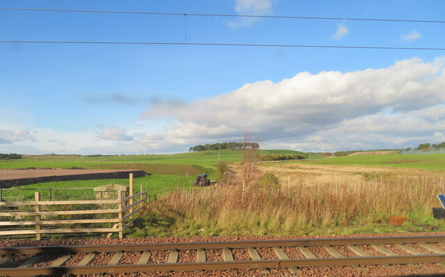
Bankhead (Lanarkshire) railway station

Bankhead railway station served the isolated settlement of Bankhead, east of Carstairs Junction in South Lanarkshire, Scotland from 1867 to 1945 on the...
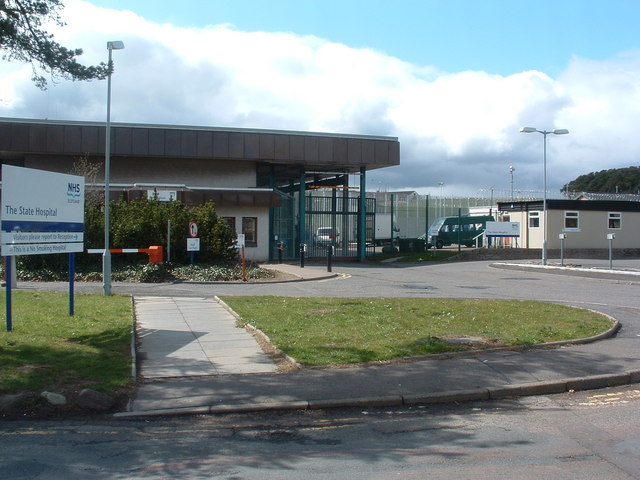
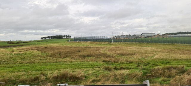
State Hospital

The State Hospital (also known as Carstairs Hospital, or simply Carstairs) is a psychiatric hospital in the village of Carstairs, in South Lanarkshire...

Carnwath

Carnwath (Gaelic: A' Chathair Nuadh; English: "New Fort") is a moorland village on the southern edge of the Pentland Hills of South Lanarkshire, Scotland...

Carnwath railway station

Carnwath railway station was located just west of the village of Carnwath, on the Caledonian Railway line between Carstairs railway station and Edinburgh...

Carstairs railway station

Carstairs railway station serves the village of Carstairs in South Lanarkshire, Scotland and is a major junction station on the West Coast Main Line (WCML...

Carstairs Junction

Carstairs Junction (Scottish Gaelic: Snaim Caisteal Tarrais) is a village in South Lanarkshire. Taking its name from the village of Carstairs and nearby...

South Medwin River

South Medwin, sometimes spelled Medwyn, is a river in the Lanarkshire region of Scotland. Along with the confluence of the North Medwin River it forms...

Pettinain

Pettinain is a hamlet and civil parish in South Lanarkshire, Scotland, 7 miles (11 km) east of Lanark. Bartholomew's Gazetteer of the British Isles described...

Nearby Amenities

Located within 500m of 55.689356,-3.6363616
Generator Method: wind_turbine
Generator Output Electricity: yes
Generator Source: wind
Generator Type: horizontal_axis
Power: generator
Lat/Long: 55.6913096/-3.6402227
Generator Method: wind_turbine
Generator Output Electricity: yes
Generator Source: wind
Generator Type: horizontal_axis
Power: generator
Lat/Long: 55.691525/-3.6421329
Noexit: yes
Lat/Long: 55.6914352/-3.6423031
Power: pole
Lat/Long: 55.6929175/-3.6408091
Power: pole
Lat/Long: 55.6932292/-3.6394993
Power: pole
Lat/Long: 55.6934982/-3.6383892
Power: pole
Lat/Long: 55.6936925/-3.6350948
The data included in this document is from www.openstreetmap.org. The data is made available under ODbL.

Have you been to The Dean?

Leave your review of The Dean below (or comments, questions and feedback).