Invernenty Glen

Valley in Perthshire

Scotland

Invernenty Glen

Rough pastureland beside the River Larig Looking south-eastward towards Invernenty.
Rough pastureland beside the River Larig Credit: Peter Wood

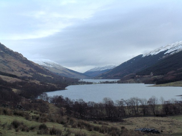
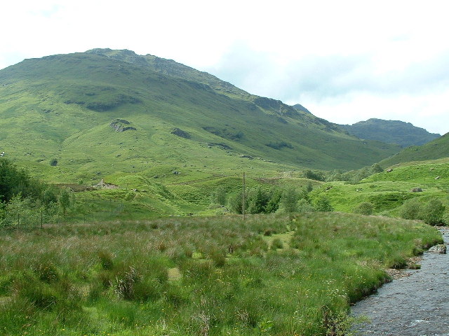
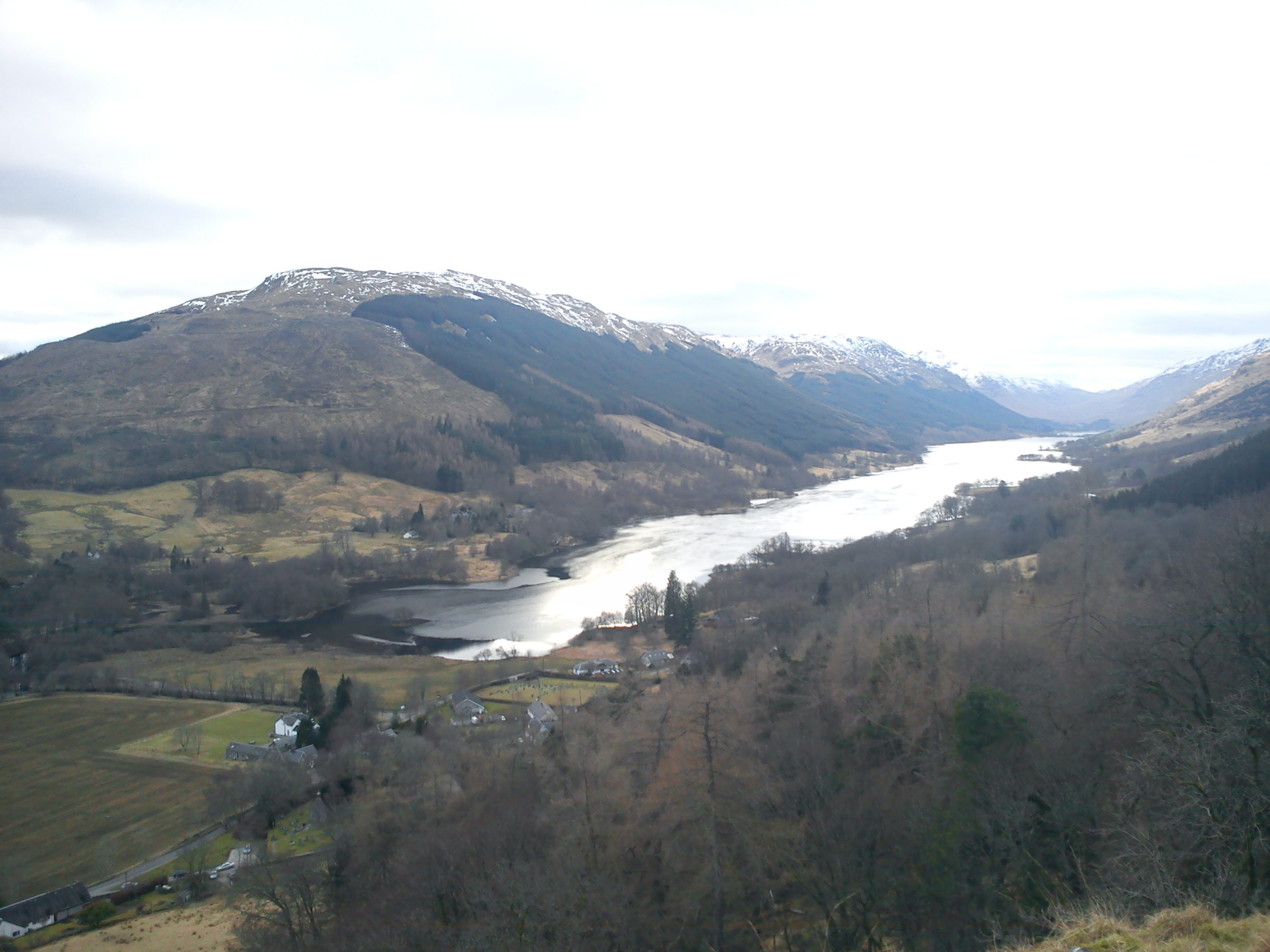
Invernenty Glen is a picturesque valley located in Perthshire, Scotland. Nestled amidst the stunning Scottish Highlands, this glen is renowned for its natural beauty and tranquil atmosphere.

Covering an area of approximately 10 square kilometers, Invernenty Glen is characterized by lush greenery, rolling hills, and a meandering river that runs through its heart. The glen is surrounded by towering mountains, creating a breathtaking backdrop for visitors to admire.

The glen is home to a diverse range of flora and fauna, making it a haven for nature enthusiasts. Visitors can expect to see vibrant wildflowers, ancient trees, and an array of bird species. The glen is also inhabited by red deer, squirrels, and other wildlife, adding to its natural charm.

Invernenty Glen offers numerous walking and hiking trails, allowing visitors to explore its beauty at their own pace. The trails vary in difficulty, catering to both casual walkers and experienced hikers. Along these trails, one can enjoy breathtaking views of the glen and its surrounding landscape.

The glen also boasts historical significance, with remnants of ancient settlements and ruins dating back centuries. These historical sites provide a glimpse into the glen's rich past and add an element of intrigue to any visit.

Overall, Invernenty Glen is a true gem of Perthshire, offering visitors a chance to connect with nature, embark on scenic walks, and immerse themselves in the history and tranquility of the Scottish Highlands.

If you have any feedback on the listing, please let us know in the comments section below.

Invernenty Glen Images

Images are sourced within 2km of 56.320548/-4.4922586 or Grid Reference NN4517. Thanks to Geograph Open Source API. All images are credited.

Rough pastureland beside the River Larig Looking south-eastward towards Invernenty.
Rough pastureland beside the River Larig
Looking south-eastward towards Invernenty.
Trees along course of River Larig The River Larig drains the upper glen in which Balquhidder is located, its water running into Loch Doine. The trees along the valley flatness appear to be still leafless in this image from early April, 1996.
Stob a' Choin is the snowy mountain, its summit being on the farthest ridge.
Trees along course of River Larig
The River Larig drains the upper glen in which Balquhidder is located, its water running into Loch Doine. The trees along the valley flatness appear to be still leafless in this image from early April, 1996. Stob a' Choin is the snowy mountain, its summit being on the farthest ridge.
Bivvy on Beinn Bhreac A view down Gleann Dubh from a pleasant midge free perch south of the triangulation pillar on Beinn Bhreac.  The view gives a mirror image of the common view of Ben Vorlich and Stuc a' Chroin seen from lowland Perthshire.
Bivvy on Beinn Bhreac
A view down Gleann Dubh from a pleasant midge free perch south of the triangulation pillar on Beinn Bhreac. The view gives a mirror image of the common view of Ben Vorlich and Stuc a' Chroin seen from lowland Perthshire.
View towards Beinn Tulaichean and Cruach Ardrain Taken from near the summit of Beinn Stacach.
View towards Beinn Tulaichean and Cruach Ardrain
Taken from near the summit of Beinn Stacach.
View down Allt Fathan Glinne Showers are moving across the Braes of Balquhidder in the distance.
View down Allt Fathan Glinne
Showers are moving across the Braes of Balquhidder in the distance.
Ruined fence, Ceann na Baintighearna This hillside is littered with the remnants of fences which have been unable to withstand the elements.  This view looks over the satellite top of Ceann na Baintighearna ('the lady's head') towards Stob Binnein, the top of which is obscured by cloud.
Ruined fence, Ceann na Baintighearna
This hillside is littered with the remnants of fences which have been unable to withstand the elements. This view looks over the satellite top of Ceann na Baintighearna ('the lady's head') towards Stob Binnein, the top of which is obscured by cloud.
Snow patch in upper branch of Allt Fathan Glinne A modest-sized remnant of winter drifts clinging on in a defile at just over 700m asl - the higher peaks around Crianlarich still had extensive snowfields on this date.
Snow patch in upper branch of Allt Fathan Glinne
A modest-sized remnant of winter drifts clinging on in a defile at just over 700m asl - the higher peaks around Crianlarich still had extensive snowfields on this date.
Boulders near Loch Doine Looking down the glen. Loch Voil is beyond Loch Doine.
Boulders near Loch Doine
Looking down the glen. Loch Voil is beyond Loch Doine.
In the Frame The remains of an old fence junction on the summit of the Corbett Stob Fear-tomhais frame the munros of Stob Binnein and Ben More. Cruach Ardrain can also be seen at the left of the image.
In the Frame
The remains of an old fence junction on the summit of the Corbett Stob Fear-tomhais frame the munros of Stob Binnein and Ben More. Cruach Ardrain can also be seen at the left of the image.
Old Fenceline Remains of a fence high up on Stob Fear-tomhais looking towards the still snow dappled Cruach Ardrain, Stob Binnean and Ben More.
Old Fenceline
Remains of a fence high up on Stob Fear-tomhais looking towards the still snow dappled Cruach Ardrain, Stob Binnean and Ben More.
Trig point on the summit of the hill Looking West from the 771m trig point towards Stob a'Choin.
Trig point on the summit of the hill
Looking West from the 771m trig point towards Stob a'Choin.
Trig  on the un-named Corbett Looking north, with Stob Creagach very faint in the far distance.
Trig on the un-named Corbett
Looking north, with Stob Creagach very faint in the far distance.
Quartzite outcrop
Quartzite outcrop
Wet Forest Track A day of contrasts as it kept changing from sharp showers to lovely sunshine with a cold wind on the tops - Edinburgh was glorious sunshine all day.
Track in the forest to the south of Inverlochlarig.
Wet Forest Track
A day of contrasts as it kept changing from sharp showers to lovely sunshine with a cold wind on the tops - Edinburgh was glorious sunshine all day. Track in the forest to the south of Inverlochlarig.
Arkle on a Graham Summit of Stob Breac a very steep Graham south of Inverlochlarig, Balquhidder.
Arkle - a wee dog named after one of the big bold Sutherland Corbetts - Arkle is neither big or bold!
Arkle on a Graham
Summit of Stob Breac a very steep Graham south of Inverlochlarig, Balquhidder. Arkle - a wee dog named after one of the big bold Sutherland Corbetts - Arkle is neither big or bold!
Loch Doine, Loch Voil beyond From near Ardcarnaig
Loch Doine, Loch Voil beyond
From near Ardcarnaig
Near Ardcarnaig Looking back down the road from Lochearnhead. The wee hill is Meall Monachyle (648m)
Near Ardcarnaig
Looking back down the road from Lochearnhead. The wee hill is Meall Monachyle (648m)
Winter Afternoon near Loch Doine
Show me another place!

Invernenty Glen is located at Grid Ref: NN4517 (Lat: 56.320548, Lng: -4.4922586)

Unitary Authority: Stirling

Police Authority: Forth Valley

What 3 Words

///shortage.both.enjoys. Near Tyndrum, Stirling

Nearby Locations

Invernenty Glen

Related Wikis

Loch Doine

Loch Doine is a small freshwater loch that lies to the west of Balquhidder in the Trossachs and Teith ward within Stirling council area of Scotland. It...

Stob a' Choin

Stob a'Choin (869 m) is a mountain in the Grampian Mountains, Scotland, north of Loch Katrine in the Loch Lomond and The Trossachs National Park. The nearest...

Beinn Tulaichean

Beinn Tulaichean is a Scottish mountain. It is not much more than the southern top of Cruach Ardrain, with a descent of only 120m before the ascent to...

Loch Voil

Loch Voil (Scottish Gaelic: Loch a' Bheothail) is a small freshwater loch that lies to the west of Balquhidder in the Stirling council area of Scotland...

Have you been to Invernenty Glen?

Leave your review of Invernenty Glen below (or comments, questions and feedback).