Laighstonehall
Settlement in Lanarkshire
Scotland
Laighstonehall
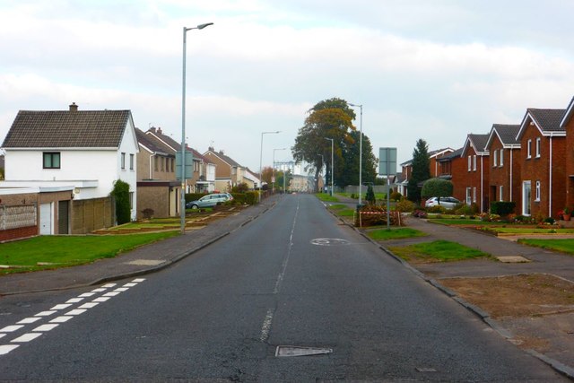
![Four-in-a-block houses in Thorntree Avenue, Hamilton Four-in-a-block flatted dwellings, Thorntree Avenue. Each house was designed to have a ground floor front door and a garden plot. Traditional tenement flats had shared entrances and shared stairs.
These were among the first 1919 Act local authority houses in Hamilton. The Glenlee housing scheme was inaugurated in October 1919 and applications for tenants for the first eight houses were invited in December 1920 [Sunday Post 5 Oct 1919; Hamilton Advertiser 11 Dec 1920].
In March 1919 it was planned to build 236 houses Glenlee. “…the lay-out plan would be on the most approved garden city lines, with approximately eleven houses to the acre, and with gardens to an average depth of 120 feet to each house.” [Hamilton Advertiser 29 March 1919].
In 1919, following the end First World War, there a housing crisis. The Housing, Town Planning, etc. (Scotland) Act 1919, one of the Addison Acts, gave local authorities the task of developing new housing and rented accommodation for working people and Government subsidies were made available. The housing estates built owed much to pre-1914 housing reformers, the Garden City movement and the professionalisation of Town Planning.](https://s2.geograph.org.uk/geophotos/07/71/20/7712002_9f6711ca.jpg)
Laighstonehall is a small settlement located in the county of Lanarkshire, Scotland. Situated approximately three miles southeast of the town of Carluke, it falls within the South Lanarkshire council area. The village is nestled amidst picturesque countryside and offers a tranquil setting for its residents.
The area surrounding Laighstonehall is predominantly rural, characterized by rolling hills, farmland, and scattered woodlands. It boasts stunning natural beauty, making it an attractive location for those seeking a peaceful retreat from the hustle and bustle of urban life.
The settlement itself consists of a small cluster of residential properties, primarily traditional stone-built houses, with some newer developments interspersed. The population of Laighstonehall is relatively modest, reflecting its rural nature and close-knit community.
Despite its small size, Laighstonehall benefits from its proximity to Carluke, which provides essential amenities such as shops, schools, and healthcare facilities. Additionally, the village enjoys good transportation links, with easy access to major roads connecting to nearby towns and cities.
The area surrounding Laighstonehall offers ample opportunities for outdoor activities such as hiking, cycling, and horseback riding. The nearby Clyde Valley provides stunning views and is renowned for its beautiful gardens and scenic walks.
Overall, Laighstonehall is a charming rural settlement that offers a peaceful and idyllic lifestyle for its residents, surrounded by the natural beauty of Lanarkshire's countryside.
If you have any feedback on the listing, please let us know in the comments section below.
Laighstonehall Images
Images are sourced within 2km of 55.76674/-4.061935 or Grid Reference NS7054. Thanks to Geograph Open Source API. All images are credited.
![Thorntree Avenue flatted houses, Hamilton Four-in-a-block flatted dwellings, Thorntree Avenue. Each house was designed to have a ground floor front door and a garden plot. Traditional tenement flats had shared entrances and shared stairs.
These were among the first 1919 Act local authority houses in Hamilton. The Glenlee housing scheme was inaugurated in October 1919 and applications for tenants for the first eight houses were invited in December 1920 [Sunday Post 5 Oct 1919; Hamilton Advertiser 11 Dec 1920].
In March 1919 it was planned to build 236 houses Glenlee. “…the lay-out plan would be on the most approved garden city lines, with approximately eleven houses to the acre, and with gardens to an average depth of 120 feet to each house.” [Hamilton Advertiser 29 March 1919].
In 1919, following the end First World War, there a housing crisis. The Housing, Town Planning, etc. (Scotland) Act 1919, one of the Addison Acts, gave local authorities the task of developing new housing and rented accommodation for working people and Government subsidies were made available. The housing estates built owed much to pre-1914 housing reformers, the Garden City movement and the professionalisation of Town Planning.](https://s3.geograph.org.uk/geophotos/07/71/20/7712003_e934f7c2.jpg)
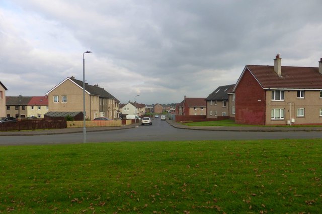
![Semi-detached houses in Russell Street, Glenlee, Hamilton These semi-detached houses in Russell Street were among the first 1919 Act local authority houses in Hamilton.
The Glenlee housing scheme was inaugurated in October 1919 and applications for tenants for the first eight houses were invited in December 1920 [Sunday Post 5 Oct 1919; Hamilton Advertiser 11 Dec 1920].
In March 1919 it was planned to build 236 houses Glenlee. “…the lay-out plan would be on the most approved garden city lines, with approximately eleven houses to the acre, and with gardens to an average depth of 120 feet to each house.” [Hamilton Advertiser 29 March 1919].
In 1919, following the end First World War, there a housing crisis. The Housing, Town Planning, etc. (Scotland) Act 1919, one of the Addison Acts, gave local authorities the task of developing new housing and rented accommodation for working people and Government subsidies were made available. The housing estates built owed much to pre-1914 housing reformers, the Garden City movement and the professionalisation of Town Planning.](https://s2.geograph.org.uk/geophotos/07/71/20/7712006_33641375.jpg)

Laighstonehall is located at Grid Ref: NS7054 (Lat: 55.76674, Lng: -4.061935)
Unitary Authority: South Lanarkshire
Police Authority: Lanarkshire
What 3 Words
///rinse.clown.loaf. Near Hamilton, South Lanarkshire
Nearby Locations
Related Wikis

Woodhead, Hamilton, Scotland
Woodhead in Hamilton, South Lanarkshire lies south of Little Earnock, and north of Meikle Earnock. There is a pub, The Woodhead, and the main area in Woodhead...
Earnock High School
Earnock High School in Hamilton, South Lanarkshire served students in and around the Earnock area from 1957 to 2007. The school was closed in June 2007...

Earnock Estate
Earnock Estate is a residential area in Hamilton, South Lanarkshire, Scotland, which is located just east of High Earnock and south of Hillhouse. The area...
Peacock Cross railway station
Peacock Cross railway station served the town of Hamilton, South Lanarkshire, Scotland, from 1878 to 1917 on the Glasgow, Bothwell, Hamilton and Coatbridge...
Nearby Amenities
Located within 500m of 55.76674,-4.061935Have you been to Laighstonehall?
Leave your review of Laighstonehall below (or comments, questions and feedback).