Richborough Hill

Hill, Mountain in Kent Dover

England

Richborough Hill

Derelict-looking outbuildings, Richborough Farm
Derelict-looking outbuildings, Richborough Farm Credit: John Baker

Richborough Hill is a prominent geographical feature located in the county of Kent, in southeastern England. Situated near the village of Richborough, the hill is part of the wider North Downs range and stands at an elevation of approximately 65 meters (213 feet) above sea level.

Covered in lush greenery and offering panoramic views of the surrounding countryside, Richborough Hill is a popular destination for nature enthusiasts and hikers alike. The hill is characterized by its gently sloping terrain, making it accessible to visitors of all ages and fitness levels.

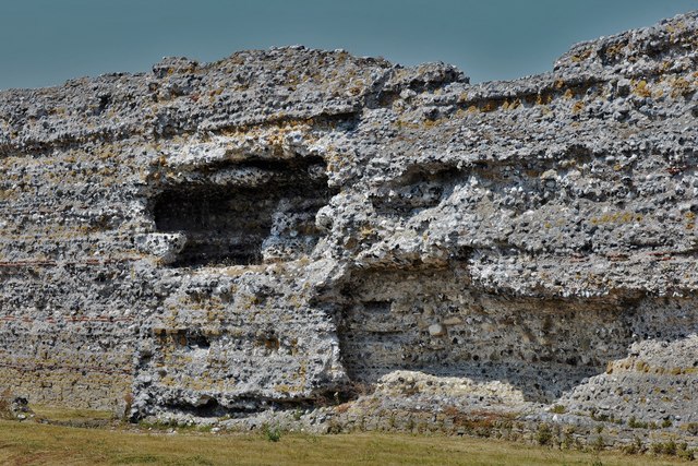
Historically, Richborough Hill holds significant importance as it is home to the remains of a Roman fort, known as Richborough Roman Fort and Amphitheatre. This fort was a key strategic location during the Roman occupation of Britain and served as a major port for the Roman navy. Today, the fort's ruins serve as a window into the past, offering visitors a glimpse into the Roman era.

Richborough Hill also plays a role in local folklore, with tales of buried treasure and ghostly sightings adding to its allure. The area surrounding the hill is rich in biodiversity, with an abundance of flora and fauna, including various species of wildflowers, butterflies, and birds.

Accessible by public transport and with ample parking facilities nearby, Richborough Hill offers a tranquil escape from the bustle of daily life, allowing visitors to appreciate the natural beauty and historical significance of this remarkable hill in Kent.

If you have any feedback on the listing, please let us know in the comments section below.

Richborough Hill Images

Images are sourced within 2km of 51.290455/1.3265024 or Grid Reference TR3259. Thanks to Geograph Open Source API. All images are credited.

Derelict-looking outbuildings, Richborough Farm
Derelict-looking outbuilding, Richborough Farm
Richborough Castle Roman Fort (Remains)
Richborough Castle
Roman Fort (Remains)
Brimstone butterfly Gonepteryx rhamni, feeding on thistle flower See <span class="nowrap"><a title="https://butterfly-conservation.org/50-1310/brimstone.html" rel="nofollow ugc noopener" href="https://butterfly-conservation.org/50-1310/brimstone.html">Link</a><img style="margin-left:2px;" alt="External link" title="External link - shift click to open in new window" src="https://s1.geograph.org.uk/img/external.png" width="10" height="10"/></span> for information about the Brimstone butterfly. It is one of the few British butterflies that overwinters. Because of this it can be seen in very early spring before other species have pupated.
Brimstone butterfly Gonepteryx rhamni, feeding on thistle flower
See LinkExternal link for information about the Brimstone butterfly. It is one of the few British butterflies that overwinters. Because of this it can be seen in very early spring before other species have pupated.
Top cow Cow enjoying the view from a pile of lime.
Top cow
Cow enjoying the view from a pile of lime.
Richborough: The Saxon shore fort walls seen from the English Heritage car park
Richborough Roman Fort: Public conveniences at the corner of the car park
Richborough: Saxon Shore Fort Wall 1
Richborough: Saxon Shore Fort Wall 2
Richborough Roman Fort: Looking towards where the west gate would have stood
Richborough: Saxon Shore Fort Wall 3, interior construction detail
Richborough: Saxon Shore Fort west wall (interior)
Richborough: Saxon Shore Fort west wall (interior detail)
Richborough: Saxon Shore Fort west wall showing where the west gate once stood
Richborough: Saxon Shore Fort North Wall with original facing blocks still in situ at base
Richborough: Saxon Shore Fort west wall, remains of the west gate
Richborough: Saxon Shore Fort West Wall (exterior detail) 1
Show me another place!

Richborough Hill is located at Grid Ref: TR3259 (Lat: 51.290455, Lng: 1.3265024)

Administrative County: Kent

District: Dover

Police Authority: Kent

What 3 Words

///apes.driveways.takeovers. Near Sandwich, Kent

Related Wikis

Richborough Castle

Richborough Castle is a Roman Saxon Shore fort better known as Richborough Roman Fort. It is situated in Richborough near Sandwich, Kent. Substantial remains...

Richborough Castle Halt railway station

Richborough Castle Halt was a minor station on the Kent Coast Line named after the nearby Richborough Castle. It opened in 1918 for military use. Public...

Richborough

Richborough () is a settlement north of Sandwich on the east coast of the county of Kent, England. Richborough lies close to the Isle of Thanet. The population...

Monk's Wall nature reserve

The Monk's Wall nature reserve is located a short distance from the quay in Sandwich, Kent and is ideal for seeing wild duck and other wildlife in a wetland...

Nearby Amenities

Located within 500m of 51.290455,1.3265024
Millennium Milepost Richborough Road
Description: 1) Dvbris 17.5, Roma 1176 2) Dvrovernvm 15.5, Londinivm 105
Image: https://www.cyclestreets.net/location/185582/cyclestreets185582.jpg
Information: guidepost
Ncn Milepost: mills
Sustrans Ref: MP 624
Tourism: information
Lat/Long: 51.2900583/1.3292917
Richborough Roman Amphitheatre
Man Made: survey_point
Source: npe
Lat/Long: 51.2898126/1.3274689
Crossing Barrier: no
Crossing Light: no
Railway: crossing
Source: Bing
Lat/Long: 51.2880781/1.3283242
Power: pole
Lat/Long: 51.2922305/1.3232383
Power: pole
Lat/Long: 51.2930004/1.3229795
Power: pole
Lat/Long: 51.287179/1.3249522
Power: pole
Lat/Long: 51.2898713/1.3240403
Power: pole
Lat/Long: 51.2906541/1.3237791
Power: pole
Lat/Long: 51.2938206/1.3227126
Power: pole
Lat/Long: 51.288292/1.3245646
Power: pole
Lat/Long: 51.2863984/1.3252221
Power: pole
Lat/Long: 51.291438/1.3235065
Power: pole
Lat/Long: 51.2890872/1.3243058
Power: pole
Lat/Long: 51.2886033/1.3282516
Power: pole
Lat/Long: 51.2889765/1.3276398
Power: pole
Lat/Long: 51.2880723/1.329107
Power: pole
Lat/Long: 51.2881747/1.3324785
Power: pole
Lat/Long: 51.2886763/1.3263281
Power: pole
Lat/Long: 51.2878585/1.3299304
Power: pole
Lat/Long: 51.2888532/1.3271195
Power: pole
Lat/Long: 51.2880187/1.3312167
Power: pole
Lat/Long: 51.2947507/1.3252526
Power: pole
Lat/Long: 51.2942543/1.3238997
Crossing Barrier: no
Crossing Light: no
Railway: crossing
Source: Bing
Lat/Long: 51.2880784/1.3282665
Barrier: entrance
Lat/Long: 51.2937042/1.330759
The data included in this document is from www.openstreetmap.org. The data is made available under ODbL.

Have you been to Richborough Hill?

Leave your review of Richborough Hill below (or comments, questions and feedback).