St James Hill

Hill, Mountain in Norfolk Norwich

England

St James Hill

Hills and Hollows, Mousehold Heath A wooded area on the edge of Mousehold Heath which looks like it might have been quarries or claypits at one time.
Hills and Hollows, Mousehold Heath Credit: Des Blenkinsopp

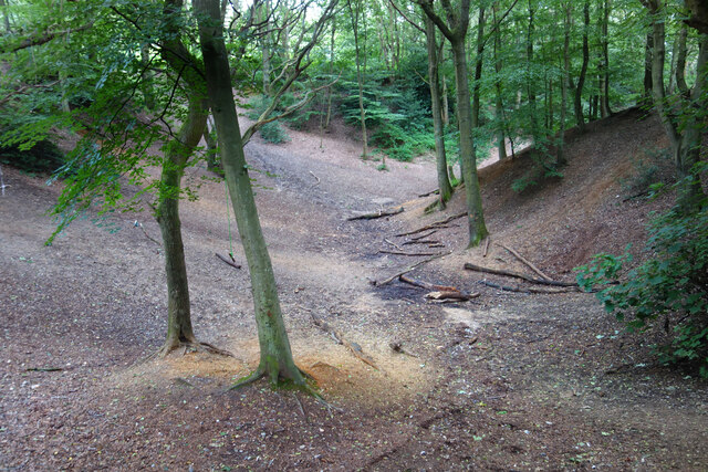
St James Hill, located in Norfolk, England, is a prominent geological feature in the region. Despite its name, it is not a hill in the traditional sense, but rather a large sand dune formed during the last ice age. Standing at a height of around 20 meters, it dominates the surrounding flat landscape.

The hill is covered with a dense vegetation comprising mainly grasses, shrubs, and some scattered trees. Its sandy composition makes it an ideal habitat for a variety of plant species adapted to such conditions. The slopes of the hill are subject to erosion, as the loose sand is easily moved by wind and rain.

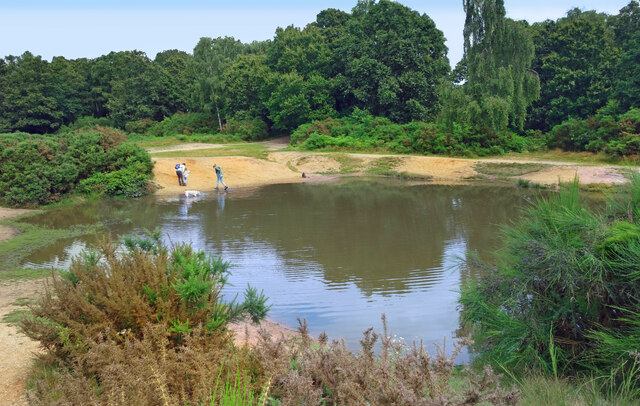
St James Hill is also a popular destination for visitors and locals alike. It offers stunning panoramic views of the surrounding countryside and the nearby coastal areas. On clear days, one can see as far as the North Sea. The hilltop is accessible via well-maintained paths, making it an excellent spot for hiking and enjoying nature.

The hill has historical significance as well. It is believed to have been used as a lookout point during medieval times, providing a strategic advantage for monitoring the surrounding areas. Today, remnants of these structures can still be seen, adding to the hill's allure.

Overall, St James Hill in Norfolk is a unique geological formation with cultural and recreational value. Its sandy slopes, diverse vegetation, and scenic views make it a noteworthy destination for nature enthusiasts and history lovers alike.

If you have any feedback on the listing, please let us know in the comments section below.

St James Hill Images

Images are sourced within 2km of 52.636352/1.3155268 or Grid Reference TG2409. Thanks to Geograph Open Source API. All images are credited.

Hills and Hollows, Mousehold Heath A wooded area on the edge of Mousehold Heath which looks like it might have been quarries or claypits at one time.
Hills and Hollows, Mousehold Heath
A wooded area on the edge of Mousehold Heath which looks like it might have been quarries or claypits at one time.
Woodland, Mousehold Heath A surviving fragment of open space now surrounded by suburban Norwich.
"In Tudor times, Mousehold Heath stretched as far north as South Walsham and was 22 miles round. The surviving remnant of the heath was given to Norwich City Council (then known as the local corporation) to look after on behalf of the citizens of Norwich in 1880." quoted from <span class="nowrap"><a title="https://www.norwich.gov.uk/info/20006/sports_parks_and_leisure/1534/about_mousehold_heath" rel="nofollow ugc noopener" href="https://www.norwich.gov.uk/info/20006/sports_parks_and_leisure/1534/about_mousehold_heath">Link</a><img style="margin-left:2px;" alt="External link" title="External link - shift click to open in new window" src="https://s1.geograph.org.uk/img/external.png" width="10" height="10"/></span>
Woodland, Mousehold Heath
A surviving fragment of open space now surrounded by suburban Norwich. "In Tudor times, Mousehold Heath stretched as far north as South Walsham and was 22 miles round. The surviving remnant of the heath was given to Norwich City Council (then known as the local corporation) to look after on behalf of the citizens of Norwich in 1880." quoted from LinkExternal link
The Vinegar Pond, Mousehold Heath The pond gets its name from the occasional red algae bloom turning the water a vinegar like colour.  A long article about the pond and the heath is on <span class="nowrap"><a title="https://www.invisibleworks.co.uk/norwich-the-vinegar-pond/" rel="nofollow ugc noopener" href="https://www.invisibleworks.co.uk/norwich-the-vinegar-pond/">Link</a><img style="margin-left:2px;" alt="External link" title="External link - shift click to open in new window" src="https://s1.geograph.org.uk/img/external.png" width="10" height="10"/></span>
The Vinegar Pond, Mousehold Heath
The pond gets its name from the occasional red algae bloom turning the water a vinegar like colour. A long article about the pond and the heath is on LinkExternal link
Track on Mousehold Heath Mousehold Heath is an 88 hectare remnant of formerly extensive heathland which was given to Norwich City Council in 1880.
It is now surrounded by suburban development.
<span class="nowrap"><a title="https://www.norwich.gov.uk/info/20006/sports_parks_and_leisure/1534/about_mousehold_heath" rel="nofollow ugc noopener" href="https://www.norwich.gov.uk/info/20006/sports_parks_and_leisure/1534/about_mousehold_heath">Link</a><img style="margin-left:2px;" alt="External link" title="External link - shift click to open in new window" src="https://s1.geograph.org.uk/img/external.png" width="10" height="10"/></span>
Track on Mousehold Heath
Mousehold Heath is an 88 hectare remnant of formerly extensive heathland which was given to Norwich City Council in 1880. It is now surrounded by suburban development. LinkExternal link
The Rosebery, New Catton Light is rapidly fading on this December afternoon but the fine old Victorian pub looks inviting. It was formerly known as the Lord Rosebery, named after Archibald Primrose who was Liberal Prime Minister between 1894 and 1895.
The Rosebery, New Catton
Light is rapidly fading on this December afternoon but the fine old Victorian pub looks inviting. It was formerly known as the Lord Rosebery, named after Archibald Primrose who was Liberal Prime Minister between 1894 and 1895.
Gurney Road through Mousehold Heath
Works at Sprowston Retail Park
Offices, Sprowston Hidden away on an industrial estate is a novel-looking office block built for British Gas "utilizing the German Burolandschaft concept, whereby the first floor is open-plan while the ground floor has areas divided by low partitions." Built in 1970-71 to the designs of the Design Group for Industry.
Now known as Sapphire House. It's not clear to what extent the internal layout has survived.
Offices, Sprowston
Hidden away on an industrial estate is a novel-looking office block built for British Gas "utilizing the German Burolandschaft concept, whereby the first floor is open-plan while the ground floor has areas divided by low partitions." Built in 1970-71 to the designs of the Design Group for Industry. Now known as Sapphire House. It's not clear to what extent the internal layout has survived.
Alderford Terrace, Magdalen Road, Norwich Some early 19th century cottages along Magdalen Road, Norwich. An OS Map from the 1880s tells me this row is called Alderford Terrace but I am not sure if the name is still in use today.
Alderford Terrace, Magdalen Road, Norwich
Some early 19th century cottages along Magdalen Road, Norwich. An OS Map from the 1880s tells me this row is called Alderford Terrace but I am not sure if the name is still in use today.
The Dyers Arms, Magdalen Road, Norwich Sadly no longer a PH having closed around 2019. The former Dyers Arms has become a "health and wellbeing clinic". In 1986 the Norwich Society described it as an "unremarkable local".

<span class="nowrap"><a title="https://www.norfolkpubs.co.uk/norwich/gnorwich/ncgld.htm" rel="nofollow ugc noopener" href="https://www.norfolkpubs.co.uk/norwich/gnorwich/ncgld.htm">Link</a><img style="margin-left:2px;" alt="External link" title="External link - shift click to open in new window" src="https://s1.geograph.org.uk/img/external.png" width="10" height="10"/></span>
The Dyers Arms, Magdalen Road, Norwich
Sadly no longer a PH having closed around 2019. The former Dyers Arms has become a "health and wellbeing clinic". In 1986 the Norwich Society described it as an "unremarkable local". LinkExternal link
Christ Church, New Catton, Norwich A view across to Christ Church, New Catton in Norwich on a wet December morning. A rather striking church dating from 1842 and, apparently, pre-dating all of the housing which surrounds it. Simon Knott's excellent Norfolk Churches site seems to suggest it has a similarly striking mint green interior which I sadly did not get to see.

<span class="nowrap"><a title="http://www.norfolkchurches.co.uk/newcatton/newcatton.htm" rel="nofollow ugc noopener" href="http://www.norfolkchurches.co.uk/newcatton/newcatton.htm">Link</a><img style="margin-left:2px;" alt="External link" title="External link - shift click to open in new window" src="https://s1.geograph.org.uk/img/external.png" width="10" height="10"/></span>
Christ Church, New Catton, Norwich
A view across to Christ Church, New Catton in Norwich on a wet December morning. A rather striking church dating from 1842 and, apparently, pre-dating all of the housing which surrounds it. Simon Knott's excellent Norfolk Churches site seems to suggest it has a similarly striking mint green interior which I sadly did not get to see. LinkExternal link
Sewell Park, New Catton, Norwich The southern entrance to Sewell Park in New Catton. The handsome triangular drinking trough here can be seen on an OS Map from the late-19th century. A final stopping place before heading into the city centre perhaps.

A similarly handsome bronze plaque can be seen behind it describing how this open space was once used and loved by Philip Edward Sewell and is now dedicated to his memory.
Sewell Park, New Catton, Norwich
The southern entrance to Sewell Park in New Catton. The handsome triangular drinking trough here can be seen on an OS Map from the late-19th century. A final stopping place before heading into the city centre perhaps. A similarly handsome bronze plaque can be seen behind it describing how this open space was once used and loved by Philip Edward Sewell and is now dedicated to his memory.
Sewell Park Academy, Norwich As with many schools in Norfolk, this one has a long history of changing with the educational winds. It was opened in 1929 as Blyth Grammar School, it became a comprehensive school in 1971 and merged with Alderman Jex School to become Blyth-Jex School in 1972. In 2008, it became Sewell Park College and, in 2015, it became Sewell Park Academy. 

Apparently a whalebone, donated by a former student, stands in the grounds.
<a href="https://www.geograph.org.uk/photo/166094">TG2310 : Whale's Jawbone Arch in the grounds of Blyth Jex School</a>
Sewell Park Academy, Norwich
As with many schools in Norfolk, this one has a long history of changing with the educational winds. It was opened in 1929 as Blyth Grammar School, it became a comprehensive school in 1971 and merged with Alderman Jex School to become Blyth-Jex School in 1972. In 2008, it became Sewell Park College and, in 2015, it became Sewell Park Academy. Apparently a whalebone, donated by a former student, stands in the grounds. TG2310 : Whale's Jawbone Arch in the grounds of Blyth Jex School
St Cuthbert, Sprowston, Norwich
St Cuthbert, Sprowston, Norwich - War Memorial
St Cuthbert, Sprowston, Norwich - East end
Show me another place!

St James Hill is located at Grid Ref: TG2409 (Lat: 52.636352, Lng: 1.3155268)

Administrative County: Norfolk

District: Norwich

Police Authority: Norfolk

What 3 Words

///newly.river.bids. Near Thorpe Hamlet, Norfolk

Nearby Locations

Gas Hill St James Hill

Related Wikis

HM Prison Norwich

HM Prison Norwich is a Category B/C multi-functional prison for adult and juvenile males, located on Mousehold Heath in Norwich, Norfolk, England. The...

Britannia Barracks

Britannia Barracks was a military installation in Norwich. == History == The barracks were built in the architectural style of Norman Shaw on Mousehold...

St James' Pit

St James' Pit is a 3.5-hectare (8.6-acre) geological Site of Special Scientific Interest in Norwich in Norfolk. It is a Geological Conservation Review...

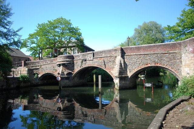
Bishop Bridge, Norwich

Bishop Bridge is a medieval bridge across the River Wensum located to the east of Norwich, England. It was built in 1340 and is still in use in the twenty...

Nearby Amenities

Located within 500m of 52.636352,1.3155268
Post Box
Collection Times: Mo-Fr 16:00; Sa 12:45
Operator: Royal Mail
Post Box Type: pillar
Ref: NR1 138
Royal Cypher: EIIR
Royal Cypher Wikidata: Q33102113
Lat/Long: 52.6336011/1.3161895
Post Box
Collection Times: Mo-Fr 18:15; Sa 11:00
Operator: Royal Mail
Postal Code: NR3
Ref: NR3 304
Lat/Long: 52.6368341/1.3095886
Heathgate, adj
Naptan AtcoCode: 2900N12163
Naptan Bearing: E
Naptan BusStopType: CUS
Naptan CommonName: Heathgate
Naptan Indicator: adj
Naptan Landmark: Heathgate
Naptan Locality: Norwich
Naptan NaptanCode: nfodjajd
Naptan PlusbusZoneRef: NRCH
Naptan Street: Mousehold Street
Naptan Verified: no
Source: naptan_import
Lat/Long: 52.6368139/1.3096106
Vincent Road, opp
Naptan AtcoCode: 2900N12556
Naptan Bearing: SW
Naptan BusStopType: CUS
Naptan CommonName: Vincent Road
Naptan Indicator: opp
Naptan Landmark: Vincent Road
Naptan Locality: Norwich
Naptan NaptanCode: nfodmdgw
Naptan PlusbusZoneRef: NRCH
Naptan Street: Plumstead Road
Naptan Verified: no
Source: naptan_import
Lat/Long: 52.633809/1.3173514
Hilary Avenue, adj
Naptan AtcoCode: 2900N12557
Naptan Bearing: NE
Naptan BusStopType: CUS
Naptan CommonName: Hilary Avenue
Naptan Indicator: adj
Naptan Landmark: Hilary Avenue
Naptan Locality: Norwich
Naptan NaptanCode: nfodmdja
Naptan PlusbusZoneRef: NRCH
Naptan ShortCommonName: Plumstead Road
Naptan Street: Plumstead Road
Naptan Verified: no
Source: naptan_import
Lat/Long: 52.6351983/1.3216241
Hilary Avenue, opp
Naptan AtcoCode: 2900N12558
Naptan Bearing: SW
Naptan BusStopType: CUS
Naptan CommonName: Hilary Avenue
Naptan Indicator: opp
Naptan Landmark: Hilary Avenue
Naptan Locality: Norwich
Naptan NaptanCode: nfodmdjd
Naptan PlusbusZoneRef: NRCH
Naptan Street: Plumstead Road
Naptan Verified: no
Source: naptan_import
Lat/Long: 52.635288/1.3223418
Bus Stop
Wolfe Road
Bus: yes
Naptan AtcoCode: 2900N12630
Naptan Bearing: NE
Naptan BusStopType: CUS
Naptan CommonName: Wolfe Road
Naptan Indicator: opp
Naptan Landmark: Thorpe Middle School
Naptan Locality: Norwich
Naptan NaptanCode: nfodmgtw
Naptan PlusbusZoneRef: NRCH
Naptan ShortCommonName: Wolfe Road
Naptan Street: Wolfe Road
Public Transport: platform
Shelter: no
Source: naptan_import;survey
Lat/Long: 52.6329482/1.3187958
Bus Stop
Wolfe Road
Bus: yes
Naptan AtcoCode: 2900N12631
Naptan Bearing: SW
Naptan BusStopType: CUS
Naptan CommonName: Wolfe Road
Naptan Indicator: adj
Naptan Landmark: Wolf Road Middle School
Naptan Locality: Norwich
Naptan NaptanCode: nfodmgwa
Naptan PlusbusZoneRef: NRCH
Naptan ShortCommonName: Wolfe Road
Naptan Street: Wolfe Road
Public Transport: platform
Shelter: no
Source: naptan_import;survey
Lat/Long: 52.6327985/1.3184748
Bus Stop
Riseway Close, opp
Naptan AtcoCode: 2900N12657
Naptan Bearing: NW
Naptan BusStopType: CUS
Naptan CommonName: Riseway Close
Naptan Indicator: opp
Naptan Locality: Norwich
Naptan NaptanCode: nfodmjma
Naptan PlusbusZoneRef: NRCH
Naptan Street: Borrowdale Drive
Naptan Verified: no
Public Transport: platform
Source: naptan_import
Lat/Long: 52.6388272/1.3199343
Bus Stop
Riseway Close, adj
Naptan AtcoCode: 2900N12658
Naptan Bearing: SE
Naptan BusStopType: CUS
Naptan CommonName: Riseway Close
Naptan Indicator: adj
Naptan Landmark: Riseway Close
Naptan Locality: Norwich
Naptan NaptanCode: nfodmjmd
Naptan PlusbusZoneRef: NRCH
Naptan Street: Borrowdale Drive
Naptan Verified: no
Public Transport: platform
Source: naptan_import
Lat/Long: 52.6386847/1.3202044
Bus Stop
Lloyd Road, adj
Naptan AtcoCode: 2900N12659
Naptan Bearing: NW
Naptan BusStopType: CUS
Naptan CommonName: Lloyd Road
Naptan Indicator: adj
Naptan Landmark: Aberdare Court
Naptan Locality: Norwich
Naptan NaptanCode: nfodmjmg
Naptan PlusbusZoneRef: NRCH
Naptan Street: Hilary Avenue
Naptan Verified: no
Public Transport: platform
Source: naptan_import
Lat/Long: 52.6359103/1.3219603
Bus Stop
Lloyd Road, opp
Naptan AtcoCode: 2900N12660
Naptan Bearing: SE
Naptan BusStopType: CUS
Naptan CommonName: Lloyd Road
Naptan Indicator: opp
Naptan Landmark: Regency Court
Naptan Locality: Norwich
Naptan NaptanCode: nfodmjmp
Naptan PlusbusZoneRef: NRCH
Naptan Street: Hilary Avenue
Naptan Verified: no
Public Transport: platform
Source: naptan_import
Lat/Long: 52.6358866/1.3218402
Bus Stop
HM Prison, adj
Bus: yes
Naptan AtcoCode: 2900N32519
Naptan Bearing: SE
Naptan CommonName: HM Prison
Naptan Indicator: adj
Naptan Landmark: H M Prison
Naptan Locality: Norwich
Naptan NaptanCode: nfogpapd
Naptan PlusbusZoneRef: NRCH
Naptan Street: Britannia Road
Naptan Verified: no
Public Transport: platform
Source: naptan_import
Lat/Long: 52.6359444/1.31451
Crossing
Crossing: unmarked
Lat/Long: 52.6343765/1.3102386
Crossing
Crossing: unmarked
Lat/Long: 52.6342899/1.3101887
Turning Circle
Lat/Long: 52.634109/1.321031
Man Made: service_area_interface
Operator: BT
Lat/Long: 52.6340006/1.3213055
Tourism: viewpoint
Viewpoint: Saint James' Hill
Lat/Long: 52.6350765/1.3123324
Crossing
Crossing: unmarked
Lat/Long: 52.6344618/1.3094641
Crossing
Crossing: unmarked
Lat/Long: 52.6345961/1.3098189
Crossing
Crossing: unmarked
Lat/Long: 52.6345959/1.3099117
Noexit: yes
Lat/Long: 52.6346166/1.3101241
Crossing
Crossing: unmarked
Lat/Long: 52.6345193/1.3095374
Vincent Road, adj
Naptan AtcoCode: 2900N12555
Naptan Bearing: NE
Naptan BusStopType: CUS
Naptan CommonName: Vincent Road
Naptan Indicator: adj
Naptan Landmark: Vincent Road
Naptan Locality: Norwich
Naptan NaptanCode: nfodmdgt
Naptan PlusbusZoneRef: NRCH
Naptan Street: Plumstead Road
Naptan Verified: no
Source: naptan_import
Lat/Long: 52.6339403/1.3174796
Crossing
Crossing: uncontrolled
Lat/Long: 52.6342956/1.3181345
Check Date: 2021-05-23
Traffic Calming: hump
Lat/Long: 52.6385858/1.3119188
Parking
St James' Hill Scenic Point
Access: yes
Lat/Long: 52.635845/1.314343
Crossing
Crossing: uncontrolled
Lat/Long: 52.6361299/1.3165795
Barrier: swing_gate
Lat/Long: 52.6391561/1.3146835
Barrier: bollard
Lat/Long: 52.6400166/1.3147292
Give Way
Lat/Long: 52.6378329/1.3208297
Give Way
Lat/Long: 52.6383998/1.3203643
Crossing
Crossing: unmarked
Lat/Long: 52.6341911/1.3097299
Crossing
Crossing: unmarked
Lat/Long: 52.6341782/1.3099055
Tourism: viewpoint
Lat/Long: 52.6329547/1.3116007
Bench
Lat/Long: 52.6329477/1.311662
Historic: ruins
Lat/Long: 52.6329308/1.3118786
Crossing
Crossing Island: yes
Tactile Paving: yes
Lat/Long: 52.6336369/1.3096802
Barrier: bollard
Lat/Long: 52.6347271/1.309885
Give Way
Lat/Long: 52.6324383/1.3155029
Entrance: main
Wheelchair: yes
Lat/Long: 52.6353773/1.3218916
Grit Bin
Lat/Long: 52.6387381/1.3121216
Check Date: 2021-05-23
Traffic Calming: cushion
Lat/Long: 52.6396818/1.3123142
Crossing
Crossing: traffic_signals
Crossing Ref: puffin
Tactile Paving: yes
Lat/Long: 52.6347263/1.3203568
Thorpe Hamlet
Colour: black
Man Made: village_sign
Material: metal
Lat/Long: 52.6342244/1.3102524
Bicycle Rental
Bicycle Rental: dropoff_point
Network: Beryl Bikes
Lat/Long: 52.6352493/1.3218923
Bicycle Rental
Britannia Road
Capacity: 6
Email: support@beryl.cc
Fee: yes
Name Signed: no
Network: Beryl - Norwich
Official Name: Britannia Road
Operator: Beryl
Operator Wikidata: Q106575369
Payment App: yes
Payment App Android: cc.beryl.basis
Payment App Ios: 1386768364
Payment Cash: no
Payment Credit Cards: no
Payment Cryptocurrencies: no
Payment Debit Cards: no
Payment Electronic Purses: no
Phone: +44 20 3003 5044
Ref Gbfs: beryl_norwich:2047
Rental: city_bike;ebike;escooter
Website: https://beryl.cc/scheme/norwich
Lat/Long: 52.6334534/1.316327
Bicycle Rental
Plumstead Road Library
Bicycle Rental: dropoff_point
Capacity: 8
Email: support@beryl.cc
Fee: yes
Name Signed: no
Network: Beryl - Norwich
Official Name: Plumstead Road Library
Operator: Beryl
Operator Wikidata: Q106575369
Payment App: yes
Payment App Android: cc.beryl.basis
Payment App Ios: 1386768364
Payment Cash: no
Payment Credit Cards: no
Payment Cryptocurrencies: no
Payment Debit Cards: no
Payment Electronic Purses: no
Phone: +44 20 3003 5044
Ref Gbfs: beryl_norwich:1959
Rental: city_bike;ebike;escooter
Website: https://beryl.cc/scheme/norwich
Lat/Long: 52.6352768/1.322001
Waste Basket
Lat/Long: 52.640579/1.3134186
Waste Basket
Colour: green
Material: plastic
Lat/Long: 52.6324783/1.3145198
Waste Basket
Colour: green
Material: plastic
Lat/Long: 52.6355156/1.3084599
Waste Basket
Lat/Long: 52.6378575/1.3143396
Waste Basket
Colour: green
Material: plastic
Lat/Long: 52.6352575/1.3223045
Waste Basket
Colour: green
Material: plastic
Lat/Long: 52.6369704/1.310098
Waste Basket
Lat/Long: 52.639096/1.3128125
Waste Basket
Lat/Long: 52.6361045/1.3141123
Waste Basket
Lat/Long: 52.6389811/1.3205257
Waste Basket
Colour: green
Material: plastic
Lat/Long: 52.6329442/1.3194264
Waste Basket
Lat/Long: 52.6406192/1.3152724
Waste Basket
Colour: green
Material: plastic
Lat/Long: 52.63403/1.3126977
Waste Basket
Lat/Long: 52.6333855/1.3121909
Waste Basket
Colour: green
Material: plastic
Lat/Long: 52.6328657/1.3187503
Waste Basket
Colour: green
Material: plastic
Lat/Long: 52.6336273/1.3199176
Waste Basket
Lat/Long: 52.6355941/1.3144788
Waste Basket
Colour: green
Material: plastic
Lat/Long: 52.6369437/1.3104423
Waste Basket
Lat/Long: 52.6364799/1.3109925
Waste Basket
Lat/Long: 52.6331717/1.3118592
Waste Basket
Lat/Long: 52.6358573/1.314265
Waste Basket
Lat/Long: 52.6342954/1.3089692
Waste Basket
Lat/Long: 52.6391501/1.3208387
Give Way
Lat/Long: 52.6354391/1.3100721
Give Way
Lat/Long: 52.6361057/1.3102859
Give Way
Lat/Long: 52.6324411/1.315417
Give Way
Lat/Long: 52.6338454/1.3134914
Give Way
Lat/Long: 52.6368697/1.3104453
Give Way
Lat/Long: 52.6365976/1.310358
Give Way
Lat/Long: 52.6330115/1.3200559
Give Way
Lat/Long: 52.6330302/1.3201532
Colour: yellow
Inscription: GAS PIPELINE CP
Marker: post
Material: concrete
Note: Seen in https://www.geograph.org.uk/photo/6202797
Utility: gas
Lat/Long: 52.6337503/1.3131633
Give Way
Lat/Long: 52.6318737/1.3153821
The data included in this document is from www.openstreetmap.org. The data is made available under ODbL.

Have you been to St James Hill?

Leave your review of St James Hill below (or comments, questions and feedback).