Barneyhill

Settlement in East Lothian

Scotland

Barneyhill

Dunbar Cement Works
Dunbar Cement Works Credit: John Darcy

Barneyhill is a small village located in East Lothian, Scotland. Situated approximately 15 miles east of the capital city, Edinburgh, it is nestled amidst the picturesque countryside of this historic region. The village is set in a tranquil and rural environment, offering residents and visitors a peaceful escape from the bustling city life.

Barneyhill is characterized by its traditional charm and close-knit community. The village is home to a small population, with a mix of residential houses and agricultural land. The surrounding landscape is dotted with rolling hills, lush green fields, and picturesque farmland, providing a scenic backdrop for those who call Barneyhill home.

Despite its rural setting, Barneyhill benefits from excellent transport links, with easy access to major roads and nearby towns. The village is well-connected to the rest of East Lothian, making it an ideal location for those seeking a peaceful retreat while still being within reach of urban amenities.

The village itself offers limited amenities, with a small local shop catering to the basic needs of residents. However, Barneyhill's proximity to neighboring towns ensures that a wider range of services, including schools, healthcare facilities, and shopping centers, are easily accessible.

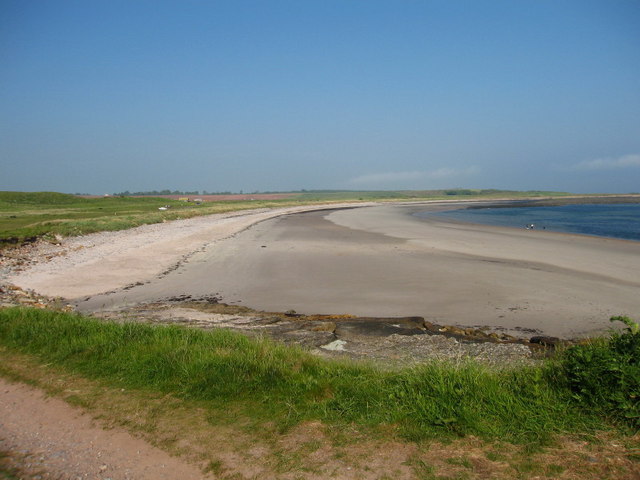
Barneyhill is also renowned for its rich history and heritage. The area is home to several historical landmarks, including ancient ruins, castles, and archaeological sites, providing a glimpse into the region's past. The village's close proximity to the stunning East Lothian coastline also offers opportunities for outdoor activities such as hiking, biking, and birdwatching.

Overall, Barneyhill is a quaint and idyllic village that offers a peaceful and scenic living environment, making it a desirable place to reside for those seeking a rural lifestyle in East Lothian.

If you have any feedback on the listing, please let us know in the comments section below.

Barneyhill Images

Images are sourced within 2km of 55.976107/-2.4662627 or Grid Reference NT7176. Thanks to Geograph Open Source API. All images are credited.

Dunbar Cement Works
Dunbar Cement Works
Quarry, Dunbar cement works. The Lothians have a fair bit of limestone, a rock notable in Scotland by its relative scarcity.  Near Barns Ness there are sufficient quantities to feed a cement works.  The works are next door, but most of NT7077 is taken up by this vast, if not deep quarry.
Quarry, Dunbar cement works.
The Lothians have a fair bit of limestone, a rock notable in Scotland by its relative scarcity. Near Barns Ness there are sufficient quantities to feed a cement works. The works are next door, but most of NT7077 is taken up by this vast, if not deep quarry.
White Sands Behind the uglyness of the limestone quarries are a series of lovely beaches. As well as the white sands, there are limestone slabs here, backed by land used previously for quarrying and a strip of very attractive links. Its managed as a country park.
White Sands
Behind the uglyness of the limestone quarries are a series of lovely beaches. As well as the white sands, there are limestone slabs here, backed by land used previously for quarrying and a strip of very attractive links. Its managed as a country park.
Bales near East Barns
Cement works at night
A1 Start of the dual carriageway section to Edinburgh. Crossing the Dry burn near Pinkerton.
A1
Start of the dual carriageway section to Edinburgh. Crossing the Dry burn near Pinkerton.
Thurston Manor Vast caravan park.
Thurston Manor
Vast caravan park.
Thurston A patch of land yet to be covered in caravans. Woodland near Thurston Manor.
Thurston
A patch of land yet to be covered in caravans. Woodland near Thurston Manor.
Beehive Doocot at Meikle Pinkerton
Chimney-stack at East Barns Farm, near Dunbar Derelict remains of East Barns Farm that includes a cart shed, granary, engine room and red brick chimney stack. The engine was likely to have been fuelled by coal as there were many coal mines in the Lothians at this time and it was used to power a threshing machine in the adjacent building.
Chimney-stack at East Barns Farm, near Dunbar
Derelict remains of East Barns Farm that includes a cart shed, granary, engine room and red brick chimney stack. The engine was likely to have been fuelled by coal as there were many coal mines in the Lothians at this time and it was used to power a threshing machine in the adjacent building.
Carthouse at East Barns Farm, near Dunbar Cart Shed at the derelict remains of East Barns Farm.<a href="https://www.geograph.org.uk/photo/146709">NT7176 : Chimney-stack at East Barns Farm, near Dunbar</a>
Carthouse at East Barns Farm, near Dunbar
Cart Shed at the derelict remains of East Barns Farm.NT7176 : Chimney-stack at East Barns Farm, near Dunbar
Farm Track at East Barns, near Dunbar View over farmland towards Barns Ness Lighthouse.
Farm Track at East Barns, near Dunbar
View over farmland towards Barns Ness Lighthouse.
Catcraig Limekilns The area around Dunbar was very important in the 18th and 19th centuries for making lime for spreading on the fields. Most was sent by cart to Berwickshire. These are a pair of mid 19th century kilns, one a 2-draw kiln, the other a 3-draw kiln. The kilns were associated with quarries, a power-house, and a track leading to a landing-place on the rocks and were closed in 1921, during the miners strike.
Catcraig Limekilns
The area around Dunbar was very important in the 18th and 19th centuries for making lime for spreading on the fields. Most was sent by cart to Berwickshire. These are a pair of mid 19th century kilns, one a 2-draw kiln, the other a 3-draw kiln. The kilns were associated with quarries, a power-house, and a track leading to a landing-place on the rocks and were closed in 1921, during the miners strike.
Red Hot Pokers Kniphofia uvaria in the dunes at Whitesands.
Red Hot Pokers
Kniphofia uvaria in the dunes at Whitesands.
White Sands View northwest towards Dunbar.
White Sands
View northwest towards Dunbar.
Water Tap Two of these at White Sands Beach, near Dunbar.
Water Tap
Two of these at White Sands Beach, near Dunbar.
Take a Rest Interesting seating on the John Muir Way at White Sands beach.
Take a Rest
Interesting seating on the John Muir Way at White Sands beach.
Ruined Building on Dunbar Golf Course Now marked on map as a sheepfold, shown on map of 1854 as a house.
Ruined Building on Dunbar Golf Course
Now marked on map as a sheepfold, shown on map of 1854 as a house.
Show me another place!

Barneyhill is located at Grid Ref: NT7176 (Lat: 55.976107, Lng: -2.4662627)

Unitary Authority: East Lothian

Police Authority: The Lothians and Scottish Borders

What 3 Words

///flipping.paddocks.covers. Near Dunbar, East Lothian

Nearby Locations

Barneyhill

Related Wikis

Battle of Dunbar (1650)

The Battle of Dunbar was fought between the English New Model Army, under Oliver Cromwell, and a Scottish army commanded by David Leslie on 3 September...

Barns Ness Lighthouse

Barns Ness Lighthouse is 3.1 miles (5 km) from Dunbar and was constructed by the engineers and brothers David A. Stevenson and Charles Alexander Stevenson...

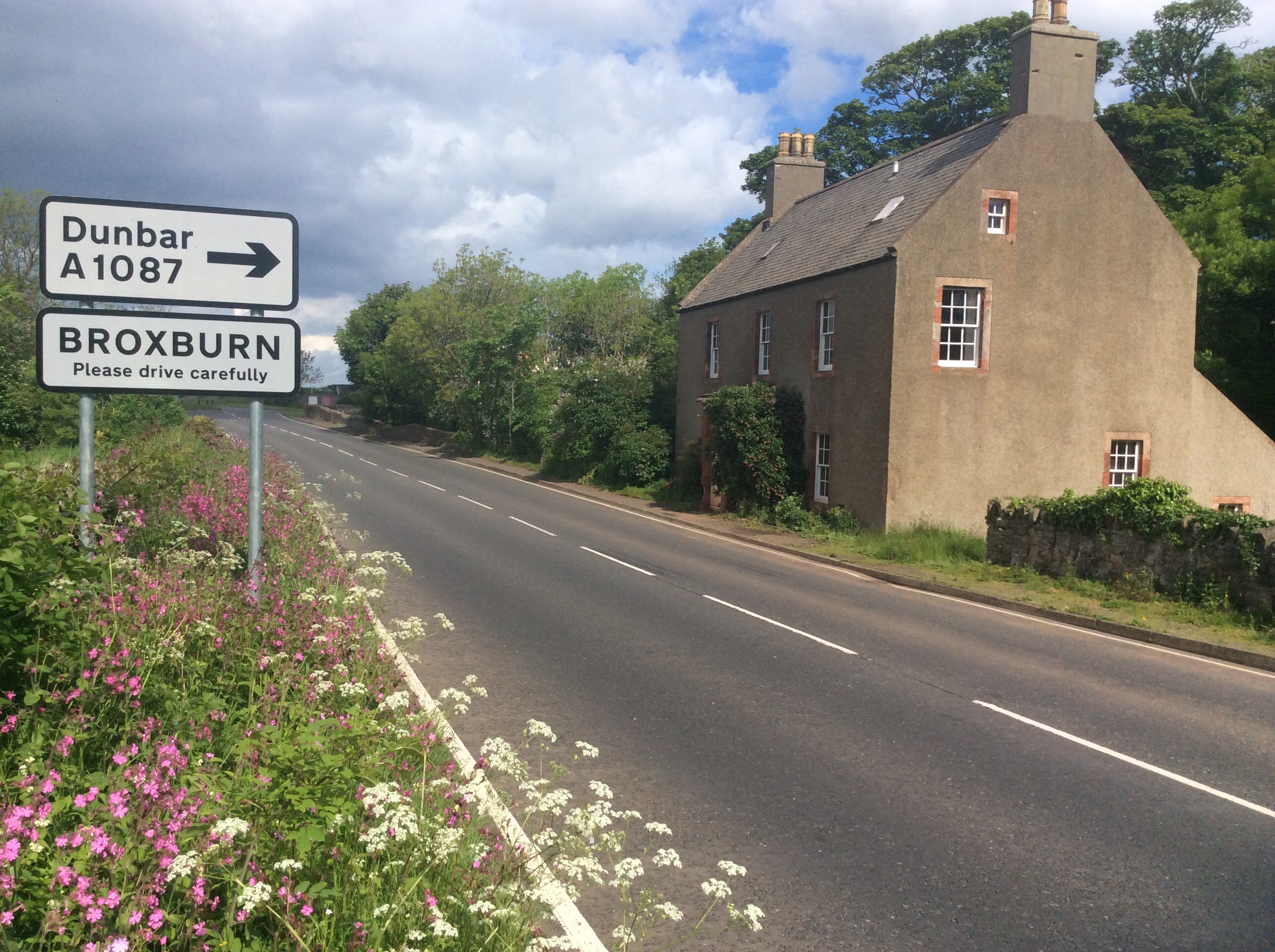
Broxburn, East Lothian

Broxburn is a hamlet consisting of a handful of scattered houses which serve the Broxmouth estate in East Lothian, Scotland. It is named after the stream...

Innerwick

Innerwick (Scottish Gaelic: Inbhir Mhuice) is a coastal civil parish and small village, which lies in the east of East Lothian, five miles (eight kilometres...

Nearby Amenities

Located within 500m of 55.976107,-2.4662627
Railway: switch
Lat/Long: 55.9801301/-2.4682499
Railway: switch
Lat/Long: 55.9802617/-2.4689692
Viridor Dunbar Rail Terminal
Railway: yard
Lat/Long: 55.9798551/-2.4670194
Man Made: chimney
Lat/Long: 55.9768241/-2.4633644
Railway: switch
Lat/Long: 55.9787747/-2.4630672
Railway: buffer_stop
Lat/Long: 55.9786071/-2.4624742
Railway: switch
Lat/Long: 55.9801323/-2.4680308
Railway: switch
Lat/Long: 55.9793/-2.4649167
Railway: switch
Lat/Long: 55.9795486/-2.4674438
Railway: switch
Lat/Long: 55.9792483/-2.4663743
Railway: buffer_stop
Lat/Long: 55.9780324/-2.461672
Railway: switch
Lat/Long: 55.9781801/-2.462261
Railway: switch
Lat/Long: 55.9783349/-2.463023
Railway: switch
Lat/Long: 55.9792235/-2.4664125
Railway: switch
Lat/Long: 55.9793529/-2.4668708
Railway: switch
Lat/Long: 55.9794069/-2.4670719
Railway: switch
Lat/Long: 55.9790807/-2.4660305
Railway: switch
Lat/Long: 55.9788883/-2.4653369
Railway: switch
Lat/Long: 55.9784036/-2.4634391
Railway: buffer_stop
Lat/Long: 55.9779525/-2.4616157
Railway: switch
Lat/Long: 55.9792525/-2.4668077
Man Made: chimney
Lat/Long: 55.9783804/-2.4699032
Barrier: cycle_barrier
Lat/Long: 55.9777469/-2.4596488
Barrier: cycle_barrier
Lat/Long: 55.9777086/-2.4595082
The data included in this document is from www.openstreetmap.org. The data is made available under ODbL.

Have you been to Barneyhill?

Leave your review of Barneyhill below (or comments, questions and feedback).