South Hill
Hill, Mountain in Sussex Lewes
England
South Hill

South Hill, Sussex is a picturesque hill located in the South Downs National Park in West Sussex, England. Standing at an elevation of approximately 240 meters (787 feet), it offers breathtaking views of the surrounding countryside and is a popular destination for outdoor enthusiasts and nature lovers.
Covered in lush greenery, South Hill is home to a diverse range of flora and fauna, making it an ideal spot for wildlife observation and nature walks. The hill is known for its rich biodiversity, with various species of birds, butterflies, and wildflowers found in abundance.
The area surrounding South Hill is dotted with charming villages and small farms, adding to its rustic and tranquil charm. The hill itself is accessible via well-marked footpaths and walking trails, allowing visitors to explore its natural beauty at their own pace.
South Hill is also steeped in history, with evidence of human habitation dating back thousands of years. Archaeological finds, including ancient burial mounds and artifacts, have been discovered in the area, adding to its historical significance.
The hill offers a range of recreational activities, such as hiking, picnicking, and photography. Many visitors also enjoy paragliding and hang gliding, taking advantage of the hill's favorable wind conditions.
Overall, South Hill, Sussex is a captivating destination that combines natural beauty, cultural heritage, and outdoor pursuits, making it a must-visit location for anyone seeking a peaceful retreat in the heart of the English countryside.
If you have any feedback on the listing, please let us know in the comments section below.
South Hill Images
Images are sourced within 2km of 50.761867/0.13394424 or Grid Reference TV5097. Thanks to Geograph Open Source API. All images are credited.
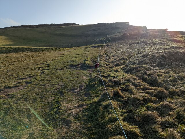


![Cuckmere Valley walk [4] The track leads into the western section of Seaford Head Local Nature Reserve.
Starting from the car park on South Hill, the route leads south towards the sea then along the cliff tops to Hope Gap, Sleaford Head and Cuckmere Haven. The way is then inland along the bank of the Cuckmere River towards Exceat Bridge, before following the long-distance Vanguard Way back to the starting point. About 4 miles.](https://s0.geograph.org.uk/geophotos/07/22/50/7225024_9a7c0af0.jpg)
![Cuckmere Valley walk [5] Ewes and lambs in the field alongside the track.
Starting from the car park on South Hill, the route leads south towards the sea then along the cliff tops to Hope Gap, Sleaford Head and Cuckmere Haven. The way is then inland along the bank of the Cuckmere River towards Exceat Bridge, before following the long-distance Vanguard Way back to the starting point. About 4 miles.](https://s3.geograph.org.uk/geophotos/07/22/50/7225027_d71b0516.jpg)
![Cuckmere Valley walk [6] From the track this path heads toward the sea.
Starting from the car park on South Hill, the route leads south towards the sea then along the cliff tops to Hope Gap, Sleaford Head and Cuckmere Haven. The way is then inland along the bank of the Cuckmere River towards Exceat Bridge, before following the long-distance Vanguard Way back to the starting point. About 4 miles.](https://s2.geograph.org.uk/geophotos/07/22/50/7225030_4afb0304.jpg)
![Cuckmere Valley walk [7] The path continues to lead towards the sea.
Starting from the car park on South Hill, the route leads south towards the sea then along the cliff tops to Hope Gap, Sleaford Head and Cuckmere Haven. The way is then inland along the bank of the Cuckmere River towards Exceat Bridge, before following the long-distance Vanguard Way back to the starting point. About 4 miles.](https://s0.geograph.org.uk/geophotos/07/22/50/7225032_4efb3364.jpg)
![Cuckmere Valley walk [8] At the junction of the paths there are three ways to go. This way heads east along the cliff edge towards Hope Gap.
Starting from the car park on South Hill, the route leads south towards the sea then along the cliff tops to Hope Gap, Sleaford Head and Cuckmere Haven. The way is then inland along the bank of the Cuckmere River towards Exceat Bridge, before following the long-distance Vanguard Way back to the starting point. About 4 miles.](https://s3.geograph.org.uk/geophotos/07/22/50/7225035_572d7d05.jpg)
![Cuckmere Valley walk [9] At the junction of the paths there are three ways to go. This way leads north towards South Hill Barn.
Starting from the car park on South Hill, the route leads south towards the sea then along the cliff tops to Hope Gap, Sleaford Head and Cuckmere Haven. The way is then inland along the bank of the Cuckmere River towards Exceat Bridge, before following the long-distance Vanguard Way back to the starting point. About 4 miles.](https://s2.geograph.org.uk/geophotos/07/22/50/7225042_eec5a09a.jpg)
![Cuckmere Valley walk [10] At the junction of the paths there are three ways to go. This way leads west towards Seaford.
Starting from the car park on South Hill, the route leads south towards the sea then along the cliff tops to Hope Gap, Sleaford Head and Cuckmere Haven. The way is then inland along the bank of the Cuckmere River towards Exceat Bridge, before following the long-distance Vanguard Way back to the starting point. About 4 miles.](https://s2.geograph.org.uk/geophotos/07/22/50/7225046_3efc4494.jpg)
![Cuckmere Valley walk [11] An information board at the junction of the paths.
Starting from the car park on South Hill, the route leads south towards the sea then along the cliff tops to Hope Gap, Sleaford Head and Cuckmere Haven. The way is then inland along the bank of the Cuckmere River towards Exceat Bridge, before following the long-distance Vanguard Way back to the starting point. About 4 miles.](https://s0.geograph.org.uk/geophotos/07/22/50/7225048_9a1ec4c2.jpg)
South Hill is located at Grid Ref: TV5097 (Lat: 50.761867, Lng: 0.13394424)
Administrative County: East Sussex
District: Lewes
Police Authority: Sussex
What 3 Words
///costumes.willpower.ship. Near Seaford, East Sussex
Nearby Locations
Related Wikis

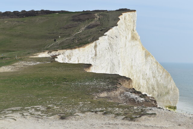
Seaford Head
Seaford Head is a 150.2-hectare (371-acre) Local Nature Reserve east of Seaford in East Sussex. It is part of Seaford to Beachy Head Site of Special Scientific...

Cuckmere Haven
Cuckmere Haven (also known as the Cuckmere estuary) is an area of flood plains in Sussex, England, where the river Cuckmere meets the English Channel between...
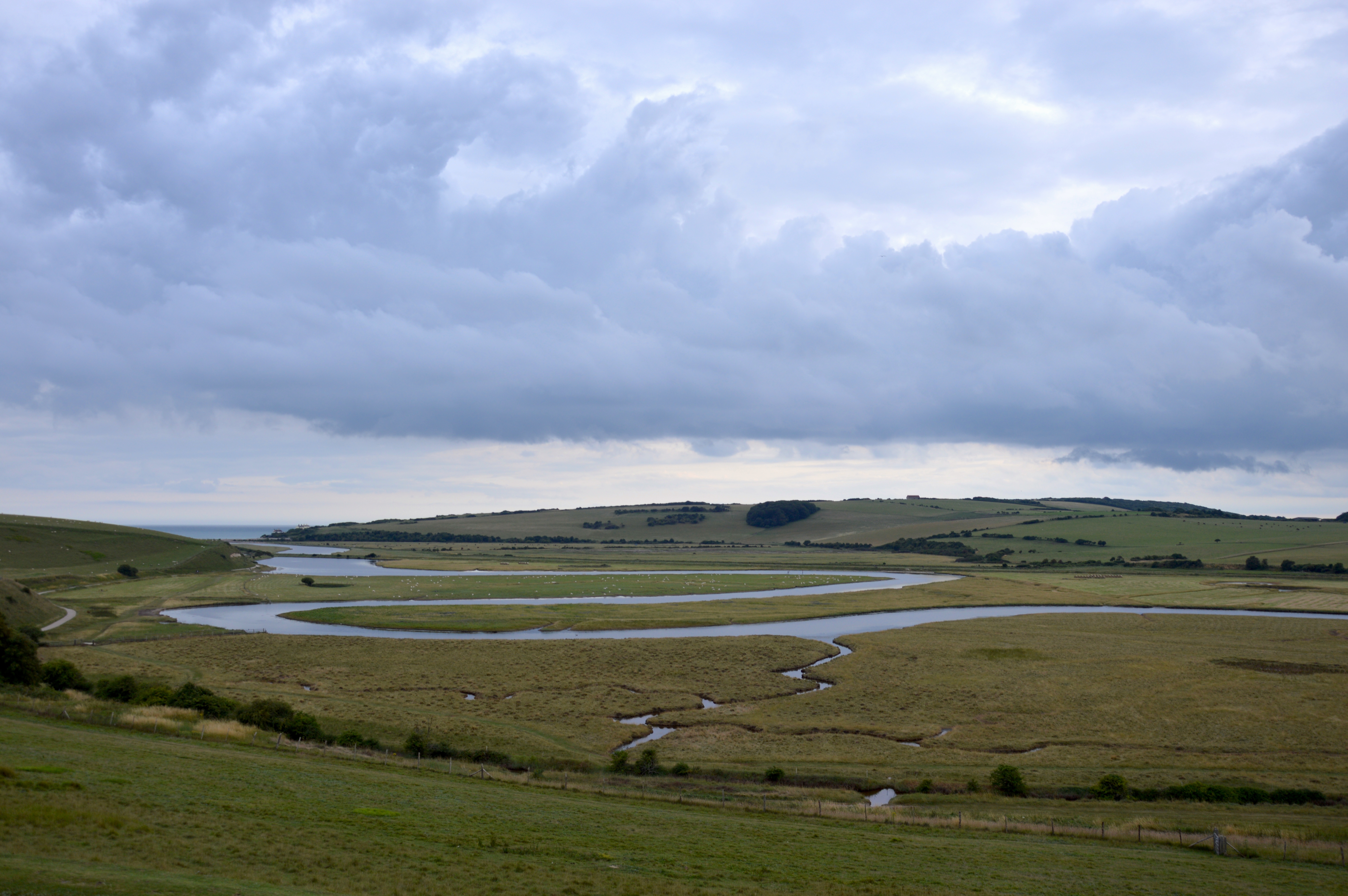
River Cuckmere
The River Cuckmere rises near Heathfield in East Sussex, England on the southern slopes of the Weald. The name of the river probably comes from an Old...

Ladycross School
Ladycross was a Catholic preparatory school in Seaford, East Sussex. It was founded in 1891 in Briely Road, Bournemouth, and moved to a purpose-built school...

Seaford Head School
Seaford Head School (formerly Seaford Head Community College), in Seaford, East Sussex, England, is a co-educational secondary school with academy status...
Seven Sisters, East Sussex
The Seven Sisters are a series of chalk sea cliffs on the English Channel coast, and are a stretch of the sea-eroded section of the South Downs range of...
Seaford Town F.C.
Seaford Town Football Club are a football club based in Seaford, East Sussex, England. They are currently members of the Southern Combination Division...

Seaford Museum
The Seaford Museum and Heritage Society is a local history museum located at the Martello Tower in East Sussex, England. It was established in 1979 and...
Nearby Amenities
Located within 500m of 50.761867,0.13394424Have you been to South Hill?
Leave your review of South Hill below (or comments, questions and feedback).