Ashanger Hill

Hill, Mountain in Hertfordshire North Hertfordshire

England

Ashanger Hill

Holy Trinity, Weston, Herts
Holy Trinity, Weston, Herts Credit: John Salmon

Ashanger Hill is a prominent hill located in the county of Hertfordshire, England. It is situated near the village of Ashanger and stands at an elevation of approximately 200 meters above sea level. The hill is part of the Chiltern Hills, a range of chalk hills that span across several counties in southern England.

The summit of Ashanger Hill offers breathtaking panoramic views of the surrounding countryside, with its lush green fields, wooded areas, and charming villages. On a clear day, visitors can see as far as the nearby towns of Tring and Wendover. The hill is a popular destination for hikers, nature enthusiasts, and those seeking peaceful retreats away from the bustling city life.

The area surrounding Ashanger Hill is rich in history and natural beauty. It is home to diverse wildlife, including several species of birds, mammals, and butterflies. The hill itself features a mix of grassy slopes and scattered trees, creating a picturesque landscape that changes with the seasons.

Access to Ashanger Hill is provided by well-maintained footpaths and trails, allowing visitors to explore the area at their leisure. The hill is also surrounded by several other attractions, including Ashanger Common, a designated Site of Special Scientific Interest due to its unique flora and fauna.

Overall, Ashanger Hill in Hertfordshire offers a serene and idyllic setting for outdoor activities, nature exploration, and an opportunity to immerse oneself in the natural beauty of the Chiltern Hills.

If you have any feedback on the listing, please let us know in the comments section below.

Ashanger Hill Images

Images are sourced within 2km of 51.971577/-0.15627754 or Grid Reference TL2631. Thanks to Geograph Open Source API. All images are credited.

Holy Trinity, Weston, Herts
Holy Trinity, Weston, Herts - Font
Holy Trinity, Weston, Herts - Corbel
Holy Trinity, Weston, Herts - Weathervane
Holy Trinity, Weston, Herts
Baldock bypass construction on Clothall Common Taken March 2005, you can see construction work on the Baldock bypass on the chalky landscape of Clothall Common
Baldock bypass construction on Clothall Common
Taken March 2005, you can see construction work on the Baldock bypass on the chalky landscape of Clothall Common
Baldock bypass tunnel in the chalk hills of Weston Taken March 2005 from TL 25217 32372, this clearly shows the chalky hills above Baldock. The contour of these hills is being preserved through the construction of the cut-and-cover tunnel you see here.
Baldock bypass tunnel in the chalk hills of Weston
Taken March 2005 from TL 25217 32372, this clearly shows the chalky hills above Baldock. The contour of these hills is being preserved through the construction of the cut-and-cover tunnel you see here.
Weston Hills This shows the rolling nature of the chalk Weston Hills with Weston woods to the left. On the horizon you can see the fence marking the edge of the Baldock bypass construction as it cuts through the hill.
Weston Hills
This shows the rolling nature of the chalk Weston Hills with Weston woods to the left. On the horizon you can see the fence marking the edge of the Baldock bypass construction as it cuts through the hill.
Baldock bypass tunnel in the chalk hills of Weston Looking south from TL254329 this shows the construction of the cut-and-cover tunnel for the Baldock bypass, which preserve the contour of the chalk hills.
Baldock bypass tunnel in the chalk hills of Weston
Looking south from TL254329 this shows the construction of the cut-and-cover tunnel for the Baldock bypass, which preserve the contour of the chalk hills.
Between Weston Hills and Bush Wood This is the corner of the copse at TL257319
Between Weston Hills and Bush Wood
This is the corner of the copse at TL257319
New saplings near Newfield Hill This plantation can be found at TL 258 319 just next to the Hertfordshire Way.
New saplings near Newfield Hill
This plantation can be found at TL 258 319 just next to the Hertfordshire Way.
Clothall from Quickswood Farm Taken from halfway up the bridleway from Clothall Road to Quickswood farm, the tiny village of Clothall can be seen top right.
Clothall from Quickswood Farm
Taken from halfway up the bridleway from Clothall Road to Quickswood farm, the tiny village of Clothall can be seen top right.
Weston Hills from Quickswood Farm Looking west we see construction work on the Baldock bypass as it cuts into the Weston Hills
Weston Hills from Quickswood Farm
Looking west we see construction work on the Baldock bypass as it cuts into the Weston Hills
Flint near Quickswood A lot of the land in this area contains flint. This was taken just outside the south end of the wooded area.
Flint near Quickswood
A lot of the land in this area contains flint. This was taken just outside the south end of the wooded area.
Barn in Quickswood Taken on the Icknield Way path at TL276333, looking south west towards the wood. Can sometimes see deer running around here, but never when you have a camera!
Barn in Quickswood
Taken on the Icknield Way path at TL276333, looking south west towards the wood. Can sometimes see deer running around here, but never when you have a camera!
Rape crop near Wallington Taken at TL279334 - you can see this dip on the contours of the grid square.
Rape crop near Wallington
Taken at TL279334 - you can see this dip on the contours of the grid square.
Show me another place!

Ashanger Hill is located at Grid Ref: TL2631 (Lat: 51.971577, Lng: -0.15627754)

Administrative County: Hertfordshire

District: North Hertfordshire

Police Authority: Hertfordshire

What 3 Words

///excavated.newspaper.clots. Near Baldock, Hertfordshire

Related Wikis

Clothall

Clothall is a village and civil parish in the county of Hertfordshire, England, with a population of 358. It is situated 2.25 miles (3.62 km) south-east...
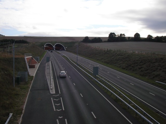
Weston Hills Tunnel

The Weston Hills Tunnel is a 230m twin road tunnel under the Weston Hills near Baldock in Hertfordshire. It was constructed as part of the A505 Baldock...

Weston, Hertfordshire

Weston is a village and civil parish in the North Hertfordshire district of Hertfordshire, England. It is located around 4 miles north of Stevenage, 2...

Lannock Mill, Weston

Lannock Mill is a Grade II listed tower mill at Weston, Hertfordshire, England which is derelict. == History == Lannock Mill was built in 1860. A windmill...

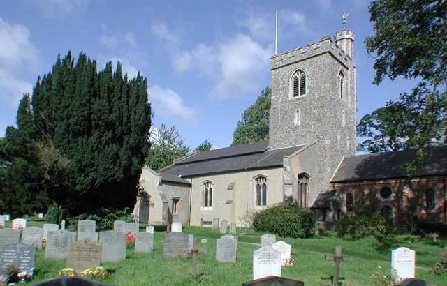
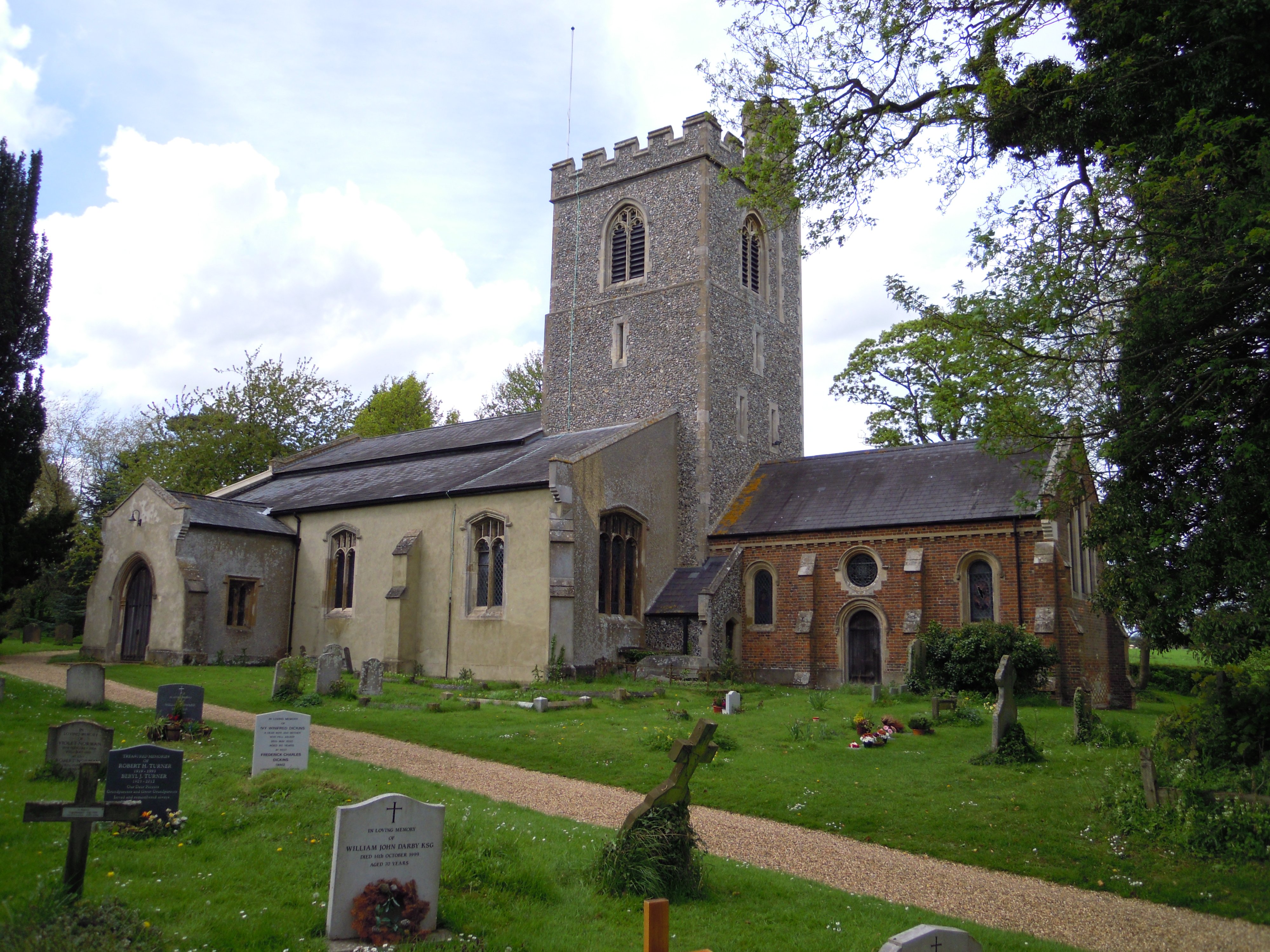
Holy Trinity Church, Weston

Holy Trinity Church is the parish church for the village of Weston in Hertfordshire. The church building stands to the south-east of the village on high...

The Knights Templar School

The Knights Templar School is a co-educational secondary school with academy status located in the market town of Baldock in North Hertfordshire, England...
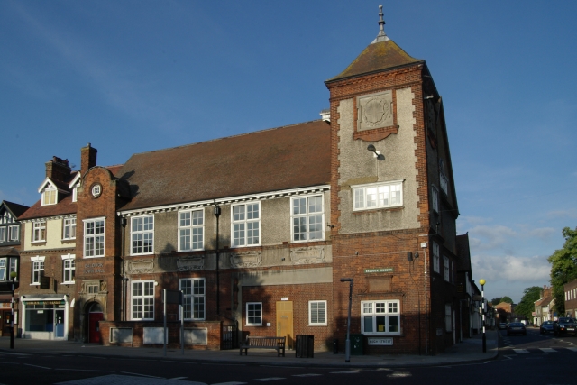
Baldock Town Hall

Baldock Town Hall is a municipal building in the High Street, Baldock, Hertfordshire, England. The structure, which now operates as an arts and heritage...

Church of St Mary the Virgin, Baldock

The Church of St Mary the Virgin is a parish church of the Church of England in Baldock in Hertfordshire. Dedicated to the Virgin Mary, the original church...

Nearby Amenities

Located within 500m of 51.971577,-0.15627754
Clothall
Place: hamlet
Source: npe
Wikidata: Q5135549
Wikipedia: en:Clothall
Lat/Long: 51.9705492/-0.1507388
Parking
Capacity: 3
Lat/Long: 51.9742105/-0.1514596
Barrier: kissing_gate
Foot: yes
Source: GPS
Lat/Long: 51.9723678/-0.1513616
Barrier: kissing_gate
Foot: yes
Source: GPS
Lat/Long: 51.9704276/-0.1497694
Post Box
Post Box Type: lamp
Ref: SG7 187
Royal Cypher: EIIR
Royal Cypher Wikidata: Q33102113
Lat/Long: 51.970985/-0.151104
Power: pole
Lat/Long: 51.9730212/-0.149399
Power: pole
Lat/Long: 51.9719967/-0.1492488
Power: pole
Lat/Long: 51.9714144/-0.1490275
Parking
Lat/Long: 51.970852/-0.1503975
Barrier: kissing_gate
Foot: yes
Source: GPS
Lat/Long: 51.9737132/-0.1505089
Barrier: kissing_gate
Lat/Long: 51.9725608/-0.1537375
Colour: red
Marker: post
Material: concrete
Utility: gas
Lat/Long: 51.9744795/-0.1534109
Colour: red
Marker: post
Material: concrete
Utility: gas
Lat/Long: 51.9746134/-0.1533507
Colour: red
Marker: post
Material: plastic
Utility: gas
Lat/Long: 51.9745059/-0.1533966
Barrier: swing_gate
Motor Vehicle: no
Lat/Long: 51.9744474/-0.1531185
Barrier: kissing_gate
Lat/Long: 51.9683499/-0.1544905
Barrier: swing_gate
Motor Vehicle: no
Lat/Long: 51.974597/-0.1531035
Ashanger Hill
Natural: hill
Lat/Long: 51.9716317/-0.1561781
The data included in this document is from www.openstreetmap.org. The data is made available under ODbL.

Have you been to Ashanger Hill?

Leave your review of Ashanger Hill below (or comments, questions and feedback).