Beech Hill

Hill, Mountain in Surrey Runnymede

England

Beech Hill

Remains of Ankerwycke Priory - looking south-east
Remains of Ankerwycke Priory - looking south-east Credit: David Kemp

Beech Hill is a small hill located in the county of Surrey, England. Standing at an approximate height of 100 meters (330 feet), it is classified as a hill rather than a mountain. Nestled within the vast Surrey Hills Area of Outstanding Natural Beauty, Beech Hill offers stunning panoramic views of the surrounding countryside.

Covered in a thick blanket of beech trees, the hill gets its name from the abundance of these majestic trees that adorn its slopes. These trees create a dense and vibrant woodland, providing a habitat for a variety of flora and fauna. The hill offers a peaceful and picturesque setting, attracting nature enthusiasts and hikers alike.

Due to its relatively low elevation, Beech Hill is easily accessible and provides an ideal location for leisurely walks and family outings. The hill is crisscrossed with well-maintained footpaths and trails, making it a popular destination for walkers and joggers. Visitors can enjoy the tranquil atmosphere, breathing in the fresh air and immersing themselves in the natural beauty that surrounds them.

In addition to its natural attractions, Beech Hill is also known for its historical significance. The area has evidence of human habitation dating back to the Roman era, with archaeological discoveries revealing remnants of ancient settlements and artifacts. These historical remnants add to the cultural heritage of the hill, making it a fascinating destination for history enthusiasts.

Overall, Beech Hill in Surrey offers a harmonious blend of natural beauty, recreational opportunities, and historical significance. It provides a serene escape from the hustle and bustle of everyday life, inviting visitors to explore its scenic trails and soak in the tranquility of the countryside.

If you have any feedback on the listing, please let us know in the comments section below.

Beech Hill Images

Images are sourced within 2km of 51.442172/-0.58480649 or Grid Reference SU9872. Thanks to Geograph Open Source API. All images are credited.

Remains of Ankerwycke Priory - looking south-east
Remains of Ankerwycke Priory - looking south-west
Remains of Ankerwycke Priory - looking north-west
Ankerwyke Farm This farm estate is owned by the National Trust and extends to the River Thames. Magna Carta Lane can be glimpsed on the right edge of this photograph and leads to the eponymous island.
Ankerwyke Farm
This farm estate is owned by the National Trust and extends to the River Thames. Magna Carta Lane can be glimpsed on the right edge of this photograph and leads to the eponymous island.
Langham Pond, Runnymede This pond is owned by the National Trust and is excellent for wildlife. In the 1970s and early 1980s it was largely covered by floating Water Soldier plants (Stratioites aloides) a rare plant in the wild. This picture from July 1990 shows some still remaining in the mid distance.
Langham Pond, Runnymede
This pond is owned by the National Trust and is excellent for wildlife. In the 1970s and early 1980s it was largely covered by floating Water Soldier plants (Stratioites aloides) a rare plant in the wild. This picture from July 1990 shows some still remaining in the mid distance.
Ankerwyke Pond Ancient pond on Magna Carta Island, Wraysbury.
Ankerwyke Pond
Ancient pond on Magna Carta Island, Wraysbury.
Langham Pond Part of a former course of the River Thames.
Langham Pond
Part of a former course of the River Thames.
Boardwalk by Langham Pond (1) Crosses a marshy area which is part of a former course of the River Thames.
Boardwalk by Langham Pond (1)
Crosses a marshy area which is part of a former course of the River Thames.
Boardwalk by Langham Pond (2) Crosses a marshy area which is part of a former course of the River Thames.
Boardwalk by Langham Pond (2)
Crosses a marshy area which is part of a former course of the River Thames.
Track on Coopers Hill Part of National Cycle Network Route 4
Track on Coopers Hill
Part of National Cycle Network Route 4
Track on Coopers Hill (2) Part of the National Cycle Network Route 4
Track on Coopers Hill (2)
Part of the National Cycle Network Route 4
Banks of the River Thames Open grassy banks are typical along the Runnymede stretch of the river. The growth of the scrub has been kept in check.
Banks of the River Thames
Open grassy banks are typical along the Runnymede stretch of the river. The growth of the scrub has been kept in check.
Air Forces Memorial, Cooper's Hill The 1971 edition of 'The Buildings of England' describes this as looking "at worst like a bad R.A.F. Officers' Mess". The interior quadrangle beyond does not justify this description.
Air Forces Memorial, Cooper's Hill
The 1971 edition of 'The Buildings of England' describes this as looking "at worst like a bad R.A.F. Officers' Mess". The interior quadrangle beyond does not justify this description.
Air Forces Memorial, Cooper's Hill - rear view Taken from the footpath on Cooper's Hill Slopes.
Air Forces Memorial, Cooper's Hill - rear view
Taken from the footpath on Cooper's Hill Slopes.
The Savill Garden, April 2022, 1 Following the line of the stream around to the Queen Elizabeth Temperate House over to the left.
The yellow plants are Lysichiton americanus, Western Skunk Cabbage.
The Savill Garden, April 2022, 1
Following the line of the stream around to the Queen Elizabeth Temperate House over to the left. The yellow plants are Lysichiton americanus, Western Skunk Cabbage.
The Savill Garden, April 2022, 2 The yellow plants are Lysichiton americanus, Western Skunk Cabbage.
The Savill Garden, April 2022, 2
The yellow plants are Lysichiton americanus, Western Skunk Cabbage.
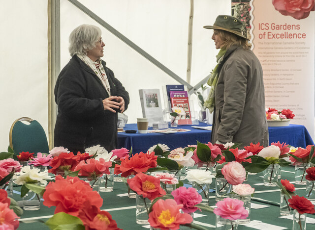
The Savill Garden, April 2022, 3 A horticultural discussion taking place at the annual early spring RHS Camellia show.
The Savill Garden, April 2022, 3
A horticultural discussion taking place at the annual early spring RHS Camellia show.
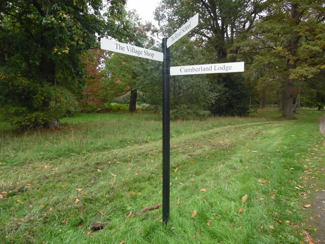
Signpost in Windsor Great Park This signpost is at a crossroads just north of Cumberland Lodge. It has direction points to Cumberland Lodge to the south, The Royal School to the west and The Village Shop to the north west.
Signpost in Windsor Great Park
This signpost is at a crossroads just north of Cumberland Lodge. It has direction points to Cumberland Lodge to the south, The Royal School to the west and The Village Shop to the north west.
Show me another place!

Beech Hill is located at Grid Ref: SU9872 (Lat: 51.442172, Lng: -0.58480649)

Administrative County: Surrey

District: Runnymede

Police Authority: Surrey

What 3 Words

///dozen.lake.bill. Near Old Windsor, Berkshire

Related Wikis

Scaitcliffe

Scaitcliffe was a prep school for boys aged 6–13 in Egham, Surrey. Founded in 1896, it was both a boarding and day school. After merging with Virginia...

St John's Beaumont School

St John's Beaumont School is a private day and boarding Jesuit preparatory school, and is for boys and girls (from September 2023) aged 3 to 13 years old...

Bishopsgate House, Egham

Bishopsgate House is a large house in Englefield Green, Egham, Surrey, England. Its 42-acre estate lies close to one of the entrances to Windsor Great...

Castle Hill, Englefield Green

Castle Hill (originally known as Elvill's) is a large late-18th-century or early-19th-century Grade II listed mansion in Englefield Green, Surrey. The...

Woodside, Old Windsor

Woodside is a large detached house with 37 acres (15 ha) of gardens in Old Windsor, Berkshire, on the edge of Windsor Great Park. The house has been rebuilt...

Beaumont College

Beaumont College was between 1861 and 1967 a public school in Old Windsor in Berkshire. Founded and run by the Society of Jesus, it offered a Roman Catholic...

Royal Indian Engineering College

The Royal Indian Engineering College (or RIEC) was a British college of Civil Engineering run by the India Office to train civil engineers for service...

Shelley's Cottage

Shelley's Cottage is a Grade II listed early 19th-century large cottage in west Englefield Green, Surrey, England within 100 metres of Windsor Great Park...

Related Videos

Colne Valley Park Amazing Walk | Hiking in London | 4K | 🇬🇧 Hiking UK | England

The Colne Valley, thatched cottages, brooks, farms, woods and undulating hills Length: 17.7 km (11.0 miles), 5 hours 30 minutes.

Bringing dream holidays home - travel inspired interior design

We have collaborated with interior designers to recreate the most iconic holiday destinations in your home, ranked by popularity.

Bringing dream holidays home - travel inspired interior design ideas

We have collaborated with interior designers to recreate the most iconic holiday destinations in your home, ranked by popularity.

Nearby Amenities

Located within 500m of 51.442172,-0.58480649
Mini Roundabout
Lat/Long: 51.4412996/-0.5900388
The Dell
Place: locality
Lat/Long: 51.4419477/-0.591171
Bishopsgate
Alt Name: Bishops Gate
Place: village
Source: OS OpenMap Local
Lat/Long: 51.4399048/-0.5888644
Beech Hill
Place: locality
Lat/Long: 51.4432934/-0.5818784
Myrtle Cottage
Place: isolated_dwelling
Lat/Long: 51.4444589/-0.5842675
The data included in this document is from www.openstreetmap.org. The data is made available under ODbL.

Have you been to Beech Hill?

Leave your review of Beech Hill below (or comments, questions and feedback).