Beacon Hill
Hill, Mountain in Hampshire New Forest
England
Beacon Hill

Beacon Hill, located in the county of Hampshire, is a stunning hill and natural landmark that stands at an elevation of 274 meters (899 feet). Situated within the South Downs National Park, it offers breathtaking panoramic views of the surrounding countryside, making it a popular destination for outdoor enthusiasts and nature lovers.
The hill is characterized by its gentle slopes and lush greenery, which is predominantly covered with open grassland and heathland. These diverse habitats support a wide range of flora and fauna, including a variety of wildflowers, butterflies, and birds. The area is also home to several species of rare orchids, which add to the hill's natural beauty.
Beacon Hill derives its name from the fact that it was historically used as a signaling point, with beacons being lit on its summit to communicate important messages across the region. This historical significance adds an extra layer of fascination to the hill and attracts visitors interested in the area's past.
In addition to its natural and historical significance, Beacon Hill offers numerous recreational opportunities for visitors. The hill is crisscrossed by several well-maintained footpaths, allowing visitors to explore its scenic trails. There is also a designated picnic area where visitors can relax and enjoy a meal amidst the picturesque surroundings.
Overall, Beacon Hill in Hampshire is a captivating natural landmark, offering stunning views, diverse wildlife, and a rich historical background. Whether you are seeking a peaceful hike, a picnic spot, or simply a place to soak in the beauty of the South Downs National Park, Beacon Hill is a must-visit destination.
If you have any feedback on the listing, please let us know in the comments section below.
Beacon Hill Images
Images are sourced within 2km of 50.880101/-1.4564682 or Grid Reference SU3809. Thanks to Geograph Open Source API. All images are credited.


Beacon Hill is located at Grid Ref: SU3809 (Lat: 50.880101, Lng: -1.4564682)
Administrative County: Hampshire
District: New Forest
Police Authority: Hampshire
What 3 Words
///seat.jobs.curl. Near Marchwood, Hampshire
Nearby Locations
Related Wikis

Southampton F.C. Under-21s and Academy
Southampton F.C. Under-21s and Academy or Saints U21s and Academy is the youth organisation run by Southampton F.C. to encourage and develop young footballers...

Marchwood railway station
Marchwood railway station was an intermediate station on the Totton, Hythe and Fawley Light Railway, which was built along the coast of Southampton Water...
Staplewood Campus
Staplewood Campus in Marchwood, Hampshire is the training ground of Southampton Football Club. It was the home ground of Road-Sea Southampton until 1987...

Marchwood
Marchwood is a village and civil parish located in Hampshire, England. It lies between Totton and Hythe on the western shore of Southampton Water and directly...
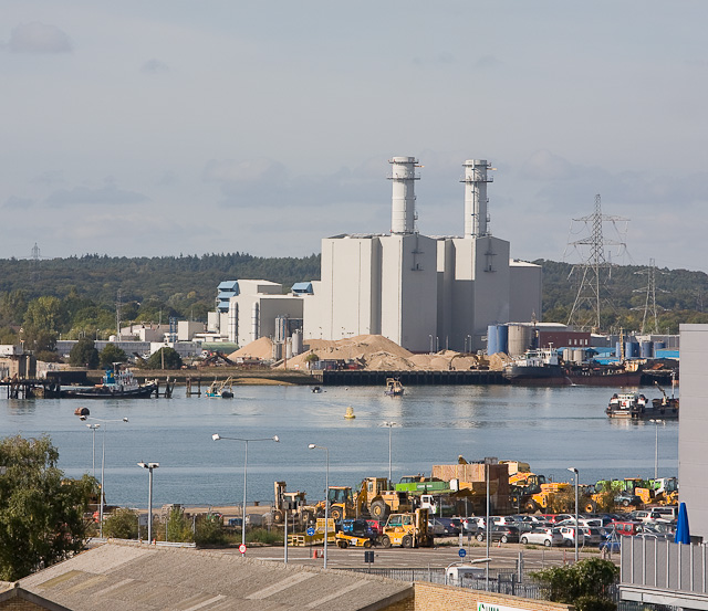
Marchwood Power Station
Marchwood Power Station is an 898.1 MW gas-fired power station in Marchwood, near Southampton, England. It is situated beside estuary of the River Test...
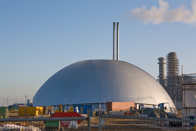
Marchwood ERF
Marchwood ERF (or Marchwood Energy Recovery Facility) is a waste incineration plant in Marchwood, near Southampton, England. It is situated beside the...

Dibden Bay
Dibden Bay is a 229.4-hectare (567-acre) biological Site of Special Scientific Interest (SSSI) between Marchwood and Hythe in Hampshire.Most of this site...
Applemore College
Applemore College is a secondary school in Hampshire, England, situated in the village of Dibden Purlieu on the edge of the New Forest. It offers education...
Nearby Amenities
Located within 500m of 50.880101,-1.4564682Have you been to Beacon Hill?
Leave your review of Beacon Hill below (or comments, questions and feedback).