Dunberry Hill

Hill, Mountain in Hampshire New Forest

England

Dunberry Hill

Old Boundary Marker by Bokerley Dyke, Damerham parish Parish Boundary Marker by the footpath, in parish of Damerham (New Forest District), Bokerley Dyke, on Southwest side of fence and footpath in plantation. 

Situated within the Knoll Camp hillfort Scheduled Monument site.
List Entry Number: 1010764 <span class="nowrap"><a title="https://historicengland.org.uk/listing/the-list/list-entry/1010764" rel="nofollow ugc noopener" href="https://historicengland.org.uk/listing/the-list/list-entry/1010764">Link</a><img style="margin-left:2px;" alt="External link" title="External link - shift click to open in new window" src="https://s1.geograph.org.uk/img/external.png" width="10" height="10"/></span>

Surveyed

Milestone Society National ID: HA_DAMROC02pb
Old Boundary Marker by Bokerley Dyke, Damerham parish Credit: Milestone Society

Dunberry Hill is a prominent landmark situated in Hampshire, England. It is classified as a hill rather than a mountain, due to its elevation and topographical features. This natural formation is located in the southwestern part of the county, near the village of Dunbridge.

Rising to a height of approximately 200 meters (656 feet) above sea level, Dunberry Hill offers picturesque views of the surrounding countryside. It is adorned with lush greenery, primarily consisting of grasses, heather, and some scattered trees. The hill's gentle slopes make it easily accessible for hikers and nature enthusiasts.

Dunberry Hill is a popular destination for outdoor activities such as walking, hiking, and birdwatching. The hill provides a habitat for various species of birds, including woodpeckers, songbirds, and birds of prey. Due to its proximity to the Test and Dun Rivers, it also attracts a diverse range of aquatic wildlife.

Visitors to Dunberry Hill can enjoy the tranquility and serenity of the natural surroundings. The hill's location away from major urban areas ensures a peaceful environment, making it an ideal spot for relaxation and contemplation. Additionally, the hill's elevation provides breathtaking panoramic views of the Hampshire countryside, with rolling hills, meandering rivers, and charming villages in the distance.

Overall, Dunberry Hill in Hampshire is a beautiful and accessible natural landmark that allows visitors to immerse themselves in the beauty of the English countryside. Whether it's for a leisurely walk or to simply enjoy the stunning vistas, Dunberry Hill offers a unique and enjoyable experience for all who visit.

If you have any feedback on the listing, please let us know in the comments section below.

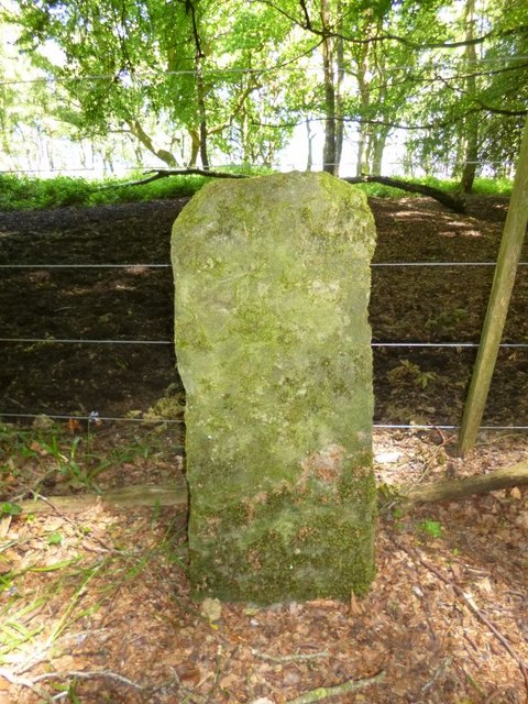
Dunberry Hill Images

Images are sourced within 2km of 50.969695/-1.8331241 or Grid Reference SU1118. Thanks to Geograph Open Source API. All images are credited.

Old Boundary Marker by Bokerley Dyke, Damerham parish Parish Boundary Marker by the footpath, in parish of Damerham (New Forest District), Bokerley Dyke, on Southwest side of fence and footpath in plantation. 

Situated within the Knoll Camp hillfort Scheduled Monument site.
List Entry Number: 1010764 <span class="nowrap"><a title="https://historicengland.org.uk/listing/the-list/list-entry/1010764" rel="nofollow ugc noopener" href="https://historicengland.org.uk/listing/the-list/list-entry/1010764">Link</a><img style="margin-left:2px;" alt="External link" title="External link - shift click to open in new window" src="https://s1.geograph.org.uk/img/external.png" width="10" height="10"/></span>

Surveyed

Milestone Society National ID: HA_DAMROC02pb
Old Boundary Marker by Bokerley Dyke, Damerham parish
Parish Boundary Marker by the footpath, in parish of Damerham (New Forest District), Bokerley Dyke, on Southwest side of fence and footpath in plantation. Situated within the Knoll Camp hillfort Scheduled Monument site. List Entry Number: 1010764 LinkExternal link Surveyed Milestone Society National ID: HA_DAMROC02pb
Daffodils beside the footpath On the way to Whitsbury. Many daffodils along this bank. I suspect they were planted by local residents.
Daffodils beside the footpath
On the way to Whitsbury. Many daffodils along this bank. I suspect they were planted by local residents.
Rockbourne The centre of the village looking north with the sign of the Rose and Thistle pub just visible.
Rockbourne
The centre of the village looking north with the sign of the Rose and Thistle pub just visible.
Log stacks near Whitsbury Common
Whitsbury Village Hall With plaque to local legend Desert Orchid trained by David Elsworth at the Wiltsbury Manor Stables winner of four King George VI Chases at Kempton Park.
Whitsbury Village Hall
With plaque to local legend Desert Orchid trained by David Elsworth at the Wiltsbury Manor Stables winner of four King George VI Chases at Kempton Park.
St Leonard's Church Above the village.
St Leonard's Church
Above the village.
Road junction near Whitsbury House
Parched fields near Whitsbury church
Steep path down to the village from Whitsbury church
Old Boundary Marker by Rockbourne Lane, Damerham Parish Parish Boundary Marker by the UC road, in parish of Damerham (New Forest District), Rockbourne Lane, edge of field next to hedge.

Surveyed

Milestone Society National ID: HA_DAMROC01pb.
Old Boundary Marker by Rockbourne Lane, Damerham Parish
Parish Boundary Marker by the UC road, in parish of Damerham (New Forest District), Rockbourne Lane, edge of field next to hedge. Surveyed Milestone Society National ID: HA_DAMROC01pb.
Direction Sign – Signpost Located on the southwest side of Whitsbury cross in Whitsbury parish. 4 arms and disc finial. See also <a title="https://www.geograph.org.uk/photo/2331232" href="https://www.geograph.org.uk/photo/2331232">Link</a> and <a title="https://www.geograph.org.uk/photo/1287344" href="https://www.geograph.org.uk/photo/1287344">Link</a>.

Milestone Society National ID: HA_SU1317
Direction Sign – Signpost
Located on the southwest side of Whitsbury cross in Whitsbury parish. 4 arms and disc finial. See also Link and Link. Milestone Society National ID: HA_SU1317
Direction Sign – Signpost Located on the west side of the T junction of Fordingbridge Road and Roundhill, north of Whitsbury cross in Whitsbury parish. 3 arms and annulus finial. 

Milestone Society National ID: HA_SU1318
Direction Sign – Signpost
Located on the west side of the T junction of Fordingbridge Road and Roundhill, north of Whitsbury cross in Whitsbury parish. 3 arms and annulus finial. Milestone Society National ID: HA_SU1318
Direction Sign – Signpost Located on the northwest side of the T junction between Roundhill Cross and Whitsbury Cross in Whitsbury parish (not Breamore as shown on the annulus). 3 arms and annulus finial. 

Milestone Society National ID: HA_SU1317A
Direction Sign – Signpost
Located on the northwest side of the T junction between Roundhill Cross and Whitsbury Cross in Whitsbury parish (not Breamore as shown on the annulus). 3 arms and annulus finial. Milestone Society National ID: HA_SU1317A
Footpath going towards Whitbury
Footpath going towards Whitbury Many daffodils in Spring.
Footpath going towards Whitbury
Many daffodils in Spring.
Bluebells in small Beech plantation
Footpath going to Rockbourne
Laid hedge
Laid hedge
Show me another place!

Dunberry Hill is located at Grid Ref: SU1118 (Lat: 50.969695, Lng: -1.8331241)

Administrative County: Hampshire

District: New Forest

Police Authority: Hampshire

What 3 Words

///picked.narrowest.dash. Near Fordingbridge, Hampshire

Related Wikis

Rockbourne

Rockbourne is a village and civil parish in the English county of Hampshire, close to Fordingbridge. == Overview == Rockbourne is a village of thatched...

Whitsbury

Whitsbury is a village and civil parish in Hampshire, England, close to Fordingbridge. Whitsbury is a part of a group of villages on the edge of the Cranborne...

Whitsbury Castle

Whitsbury Castle, or Whitsbury Castle Ditches, is the site of an Iron Age univallate hillfort located near the village of Whitsbury in Hampshire. The fort...

Rockbourne Roman Villa

Rockbourne Roman Villa is a Roman courtyard villa excavated and put on public display in the village of Rockbourne in the English county of Hampshire....

Knoll Camp

Knoll Camp, or Damerham Knoll, is the site of an Iron Age univallate hill fort located in Hampshire. The fort comprises a circular earthwork containing...
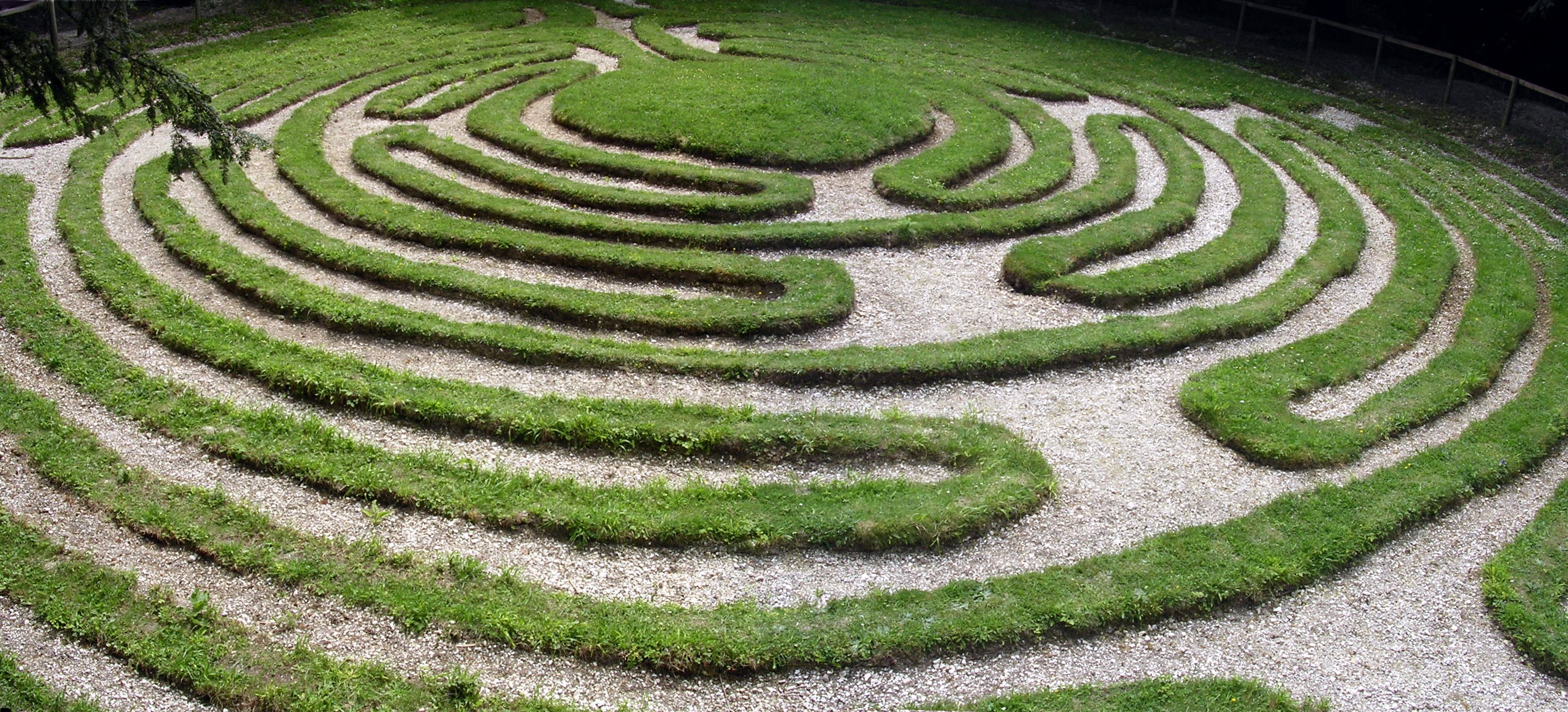
Mizmaze

Mizmaze (or Miz-Maze or Miz Maze) is the name given to two of England's eight surviving historic turf mazes, and also to a third, presumably once similar...

Damerham

Damerham is a rural village and civil parish in the New Forest district of Hampshire, England, near Fordingbridge. The area has notable Neolithic and Bronze...

Breamore Priory

Breamore Priory was a priory of Austin canons in Breamore, Hampshire, England. == Foundation == The priory was founded some time towards the end of the...

Nearby Amenities

Located within 500m of 50.969695,-1.8331241
Power: pole
Source: bing
Lat/Long: 50.9655921/-1.8352573
Power: pole
Source: bing
Lat/Long: 50.966196/-1.8352452
Power: pole
Source: bing
Lat/Long: 50.9667154/-1.8361799
Power: pole
Source: bing
Lat/Long: 50.9671048/-1.8369028
Power: pole
Source: bing
Lat/Long: 50.9675676/-1.8377396
Power: pole
Source: bing
Lat/Long: 50.9680271/-1.8385912
Power: pole
Source: bing
Lat/Long: 50.9685397/-1.8394858
Power: pole
Source: bing
Lat/Long: 50.9714728/-1.8385778
Power: pole
Source: bing
Lat/Long: 50.9721239/-1.8376337
Power: pole
Source: bing
Lat/Long: 50.9727766/-1.8366976
Power: pole
Source: bing
Lat/Long: 50.9734328/-1.8357615
The data included in this document is from www.openstreetmap.org. The data is made available under ODbL.

Have you been to Dunberry Hill?

Leave your review of Dunberry Hill below (or comments, questions and feedback).