Barkestone-le-Vale

Settlement in Leicestershire Melton

England

Barkestone-le-Vale

Barkestone Trig Point Flush Bracket S1750 Knocked over and repaired according to local dog walker.
Barkestone Trig Point Flush Bracket S1750 Credit: thejackrustles

Barkestone-le-Vale is a small village located in the district of Melton, in the county of Leicestershire, England. Situated approximately 19 miles east of Nottingham and 20 miles north-east of Leicester, it is nestled in the picturesque Vale of Belvoir.

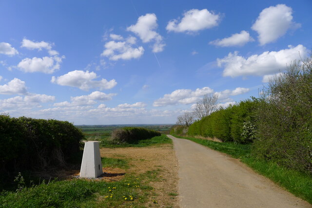
The village is known for its tranquil and rural setting, characterized by rolling hills, lush green fields, and charming countryside scenery. It is surrounded by several other villages such as Redmile, Plungar, and Bottesford, which adds to its close-knit community feel.

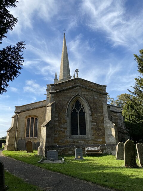
Barkestone-le-Vale has a rich history dating back to the Saxon times, evident by the presence of St. Peter's Church, a Grade II listed building that dates back to the 12th century. The church's architecture features a mix of Norman and Gothic elements, making it a significant historical and architectural landmark.

The village is primarily residential, with a small population of around 300 residents. It offers a peaceful and idyllic atmosphere, making it an ideal place for those seeking a quiet and relaxed lifestyle away from the hustle and bustle of larger towns and cities.

Although the village itself does not have many amenities, the nearby village of Bottesford provides a range of facilities including shops, pubs, and a primary school. Additionally, the city of Nottingham and the town of Melton Mowbray, both within easy reach, offer a wider range of services and amenities.

Overall, Barkestone-le-Vale is a charming and picturesque village that offers a peaceful and close-knit community, making it an appealing place for those seeking a serene countryside lifestyle.

If you have any feedback on the listing, please let us know in the comments section below.

Barkestone-le-Vale Images

Images are sourced within 2km of 52.905981/-0.859245 or Grid Reference SK7834. Thanks to Geograph Open Source API. All images are credited.

Barkestone Trig Point Flush Bracket S1750 Knocked over and repaired according to local dog walker.
Barkestone Trig Point Flush Bracket S1750
Knocked over and repaired according to local dog walker.
Church of Saint Peter and Saint Paul, Barkestone Grade II* listed, mainly 14thC with tower (and presumably the plain octagonal spire) rebuilt 1840.
Church of Saint Peter and Saint Paul, Barkestone
Grade II* listed, mainly 14thC with tower (and presumably the plain octagonal spire) rebuilt 1840.
Church of Saint Peter and Saint Paul, Barkestone Grade II* listed, mainly 14thC with tower (and presumably the plain octagonal spire) rebuilt 1840.
Church of Saint Peter and Saint Paul, Barkestone
Grade II* listed, mainly 14thC with tower (and presumably the plain octagonal spire) rebuilt 1840.
OS Cut Mark: - Barkestone-le-Vale, St John's Church <span class="nowrap"><a title="https://www.bench-marks.org.uk/bm70985" rel="nofollow ugc noopener" href="https://www.bench-marks.org.uk/bm70985">Link</a><img style="margin-left:2px;" alt="External link" title="External link - shift click to open in new window" src="https://s1.geograph.org.uk/img/external.png" width="10" height="10"/></span>
OS Cut Mark: - Barkestone-le-Vale, St John's Church
Location of OS Cut Mark: - Barkestone-le-Vale, St John's Church <span class="nowrap"><a title="https://www.bench-marks.org.uk/bm70985" rel="nofollow ugc noopener" href="https://www.bench-marks.org.uk/bm70985">Link</a><img style="margin-left:2px;" alt="External link" title="External link - shift click to open in new window" src="https://s1.geograph.org.uk/img/external.png" width="10" height="10"/></span>
Location of OS Cut Mark: - Barkestone-le-Vale, St John's Church
The Chequers Village Hub, Barkeston-le-Vale The former Chequers Inn was purchased in 2019 for the village to use as a Community Hub <span class="nowrap"><a title="http://www.barkestonevillagehub.org/" rel="nofollow ugc noopener" href="http://www.barkestonevillagehub.org/">Link</a><img style="margin-left:2px;" alt="External link" title="External link - shift click to open in new window" src="https://s1.geograph.org.uk/img/external.png" width="10" height="10"/></span>
The Chequers Village Hub, Barkeston-le-Vale
The former Chequers Inn was purchased in 2019 for the village to use as a Community Hub LinkExternal link
Footpath entering Barkestone-le-Vale
Field north-east of Jericho Covert. Future solar farm? Part of productive arable land subject of planning permission for "Installation of a solar farm comprising ground mounted solar PV panels with a net generating capacity (AC) of up to 49.9MW, including mounting system, battery storage units, inverters, underground cabling, stock proof fence, CCTV, internal tracks and associated infrastructure, landscaping and environmental enhancements for a temporary period of 40 years and a permanent grid connection hub." (Application 20/01182/FUL to Melton Borough Council)
Field north-east of Jericho Covert. Future solar farm?
Part of productive arable land subject of planning permission for "Installation of a solar farm comprising ground mounted solar PV panels with a net generating capacity (AC) of up to 49.9MW, including mounting system, battery storage units, inverters, underground cabling, stock proof fence, CCTV, internal tracks and associated infrastructure, landscaping and environmental enhancements for a temporary period of 40 years and a permanent grid connection hub." (Application 20/01182/FUL to Melton Borough Council)
Jericho Covert, Vale of Belvoir The name 'Jericho' may reflect the covert's relatively romote location - on the county boundary in the middle of the Vale (The Survey of English Place-Names)
Jericho Covert, Vale of Belvoir
The name 'Jericho' may reflect the covert's relatively romote location - on the county boundary in the middle of the Vale (The Survey of English Place-Names)
Path along the north edge of Jericho Covert Following the county boundary through the Vale of Belvoir.
Path along the north edge of Jericho Covert
Following the county boundary through the Vale of Belvoir.
Byway north-west of Barkestone-le-Vale
Byway north-west of Barkestone-le-Vale Heading into the Vale of Belvoir
Byway north-west of Barkestone-le-Vale
Heading into the Vale of Belvoir
Byway towards Barkestone-le-Vale Crossing the Grantham Canal
Byway towards Barkestone-le-Vale
Crossing the Grantham Canal
The Vale of Belvoir View north-west, from the relatively elevated ground south of the Grantham Canal.
The Vale of Belvoir
View north-west, from the relatively elevated ground south of the Grantham Canal.
Trig point near Barkestone-le-Vale Would have had good visibility when the hedges were absent. Bracket no. S1750.
Trig point near Barkestone-le-Vale
Would have had good visibility when the hedges were absent. Bracket no. S1750.
The Old School, Barkestone-le-Vale "This former C of E school opened in 1814 and closed in 1989 after which it was used as the village hall until it was sold at auction in June 2007. Planning permission had been granted to convert the property into a single dwelling in 2006"  <span class="nowrap"><a title="https://www.bha-architecture.co.uk/images/case-study-old-school-barkeston-le-vale.pdf" rel="nofollow ugc noopener" href="https://www.bha-architecture.co.uk/images/case-study-old-school-barkeston-le-vale.pdf">Link</a><img style="margin-left:2px;" alt="External link" title="External link - shift click to open in new window" src="https://s1.geograph.org.uk/img/external.png" width="10" height="10"/></span>
The Old School, Barkestone-le-Vale
"This former C of E school opened in 1814 and closed in 1989 after which it was used as the village hall until it was sold at auction in June 2007. Planning permission had been granted to convert the property into a single dwelling in 2006" LinkExternal link
Church of St Peter and St Paul, Barkestone-le-Vale "Mainly C14 with C15 alterations" <span class="nowrap"><a title="https://historicengland.org.uk/listing/the-list/list-entry/1188593?section=official-list-entry" rel="nofollow ugc noopener" href="https://historicengland.org.uk/listing/the-list/list-entry/1188593?section=official-list-entry">Link</a><img style="margin-left:2px;" alt="External link" title="External link - shift click to open in new window" src="https://s1.geograph.org.uk/img/external.png" width="10" height="10"/></span>
Large yew trees prevent a photograph of the whole church
Church of St Peter and St Paul, Barkestone-le-Vale
"Mainly C14 with C15 alterations" LinkExternal link Large yew trees prevent a photograph of the whole church
Bridleway beneath a disused railway line Part of the Great Northern and London and North Western Joint Railway network, which was mainly used for carrying iron ore and agricultural produce <span class="nowrap"><a title="https://en.wikipedia.org/wiki/Great_Northern_and_London_and_North_Western_Joint_Railway" rel="nofollow ugc noopener" href="https://en.wikipedia.org/wiki/Great_Northern_and_London_and_North_Western_Joint_Railway">Link</a><img style="margin-left:2px;" alt="External link" title="External link - shift click to open in new window" src="https://s1.geograph.org.uk/img/external.png" width="10" height="10"/></span> . The bridleway is running on the Leicestershire-Nottinghamshire county boundary.
Bridleway beneath a disused railway line
Part of the Great Northern and London and North Western Joint Railway network, which was mainly used for carrying iron ore and agricultural produce LinkExternal link . The bridleway is running on the Leicestershire-Nottinghamshire county boundary.
Show me another place!

Barkestone-le-Vale is located at Grid Ref: SK7834 (Lat: 52.905981, Lng: -0.859245)

Administrative County: Leicestershire

District: Melton

Police Authority: Leicestershire

What 3 Words

///banks.norms.candy. Near Bottesford, Leicestershire

Nearby Locations

Barkestone-le-Vale Redmile

Related Wikis

Church of St Peter and St Paul, Barkestone-le-Vale

The Church of St Peter and St Paul is a church in Barkestone-le-Vale, Leicestershire, England. It is a Grade II* listed building. == History == The church...

Plungar

Plungar is a village and former civil parish, now in the parish of Redmile, and the Melton district of Leicestershire, England. It is about 9 miles (14...

Grantham Canal SSSI

Grantham Canal SSSI is a 9.5-hectare (23-acre) biological Site of Special Scientific Interest which runs along a stretch of the Grantham Canal and its...

Vale of Belvoir

The Vale of Belvoir ( BEE-vər) covers adjacent areas of Leicestershire, Nottinghamshire and Lincolnshire, England. The name derives from the Norman-French...

Nearby Amenities

Located within 500m of 52.905981,-0.859245
Power: tower
Source: OS OpenData VectorMap District
Lat/Long: 52.9040716/-0.865358
Power: tower
Source: OS OpenData VectorMap District
Lat/Long: 52.90689/-0.8663658
The data included in this document is from www.openstreetmap.org. The data is made available under ODbL.

Have you been to Barkestone-le-Vale?

Leave your review of Barkestone-le-Vale below (or comments, questions and feedback).