Whitestone Hill

Hill, Mountain in Aberdeenshire

Scotland

Whitestone Hill

Hill of Dudwick Hill of Dudwick 174m (Trump) at the fence for the weather radar compound. (close to trig point)
Hill of Dudwick Credit: Ralph Greig

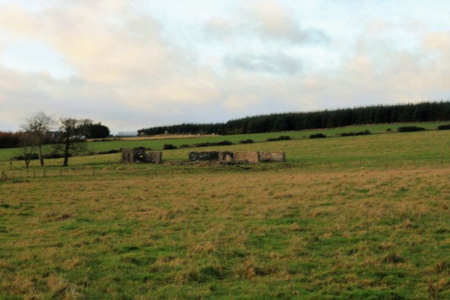
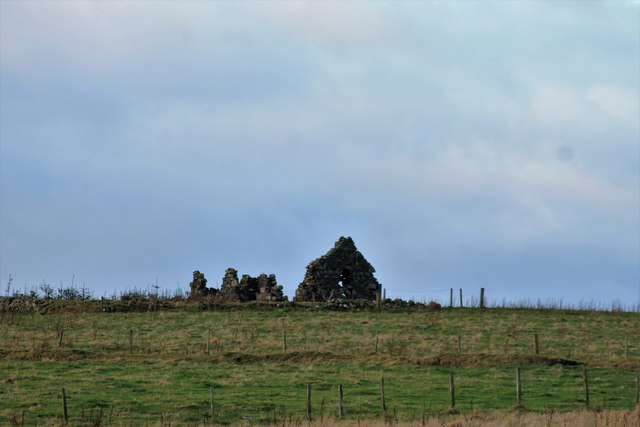
Whitestone Hill is a prominent hill located in Aberdeenshire, Scotland. Standing at an elevation of approximately 650 feet, it is considered a significant landmark in the area. The hill is situated about 3 miles southwest of the town of Ellon and is easily accessible to visitors.

The name "Whitestone Hill" derives from the light-colored stones found abundantly throughout the area. These stones, composed mainly of granite, give the hill a distinctive appearance, especially when sunlight reflects off their surfaces. The hill is covered in grass and heather, creating a picturesque landscape.

Whitestone Hill offers breathtaking panoramic views of the surrounding countryside. From its summit, one can see rolling hills, farmland, and distant mountains. On clear days, the North Sea can also be seen shimmering in the distance. The hill provides an excellent vantage point for photographers and nature enthusiasts alike.

Aside from its natural beauty, Whitestone Hill has historical significance. It is believed to have been a site of human habitation since ancient times, with archaeological evidence suggesting that the hill was once occupied by Neolithic and Iron Age communities. Additionally, the hill is said to have played a role in the battles fought during the Scottish Wars of Independence.

Today, Whitestone Hill remains a popular destination for locals and tourists seeking a peaceful escape into nature. Its accessibility and stunning vistas make it an ideal spot for hiking, picnicking, and simply enjoying the tranquility of the Scottish countryside.

If you have any feedback on the listing, please let us know in the comments section below.

Whitestone Hill Images

Images are sourced within 2km of 57.442189/-2.037701 or Grid Reference NJ9739. Thanks to Geograph Open Source API. All images are credited.

Hill of Dudwick Hill of Dudwick 174m (Trump) at the fence for the weather radar compound. (close to trig point)
Hill of Dudwick
Hill of Dudwick 174m (Trump) at the fence for the weather radar compound. (close to trig point)
Minor road near Scotston
Minor road at Belt of Muirtack
Minor road near South Craighead
Minor road near North Craighead
Little Mains The converted farm of little Mains of Dudwick.
Little Mains
The converted farm of little Mains of Dudwick.
Ruin by Dudwick An old ruined croft by woodland on the Hill of Dudwick.
Ruin by Dudwick
An old ruined croft by woodland on the Hill of Dudwick.
Arthrath Ruins North Arthtrath or what remains of this old small farm.
Arthrath Ruins
North Arthtrath or what remains of this old small farm.
Hill of Dudwick Ruins An extensive range of farm ruins and "golfball" on the Hill of Dudwick.
Hill of Dudwick Ruins
An extensive range of farm ruins and "golfball" on the Hill of Dudwick.
Laverockley Ruin Laverockley, translating as pasture of the lark, this ruin has reverted to nature the old ruins decaying.
Laverockley Ruin
Laverockley, translating as pasture of the lark, this ruin has reverted to nature the old ruins decaying.
Dudwick trig The "golf ball" is part of the Met Office's Rainfall Radar Network.
Dudwick trig
The "golf ball" is part of the Met Office's Rainfall Radar Network.
North Craighead Once a farm with rough marginal land, which is now a forestry plantation and the steading is the base for a car sales business. Craighead Cars and ATVs
North Craighead
Once a farm with rough marginal land, which is now a forestry plantation and the steading is the base for a car sales business. Craighead Cars and ATVs
Tree Plantation at Mosstown of Dudwick More 'marginal-to-useless' farmland reverting to more logical use as Forestry area.
Tree Plantation at Mosstown of Dudwick
More 'marginal-to-useless' farmland reverting to more logical use as Forestry area.
Firebreak in the Forest I'm not sure if the look-out platform is for the benefit of bird-watchers or pheasant shooters.
Firebreak in the Forest
I'm not sure if the look-out platform is for the benefit of bird-watchers or pheasant shooters.
Fortrie
Fortrie
Whiteburn Basic Dutch Barn - part of an unmodernised farmstead (no fancy new mega-sheds)
Plenty rusted corrugated iron for roofing
Whiteburn
Basic Dutch Barn - part of an unmodernised farmstead (no fancy new mega-sheds) Plenty rusted corrugated iron for roofing
Whiteburn
Whiteburn
Whiteburn Double silage pit
Whiteburn
Double silage pit
Show me another place!

Whitestone Hill is located at Grid Ref: NJ9739 (Lat: 57.442189, Lng: -2.037701)

Unitary Authority: Aberdeenshire

Police Authority: North East

What 3 Words

///movement.snippet.joyously. Near Ellon, Aberdeenshire

Nearby Locations

Whitestone Hill

Related Wikis

Skelmuir Hill

Skelmuir Hill is a landform in Aberdeenshire, Scotland. This is the location of a trig point or official government survey marker. Skelmuir Hill is the...

Kinmuck Castle

Kinmuck Castle was a 14th-century castle, about 4.0 miles (6.4 km) north-east of Ellon, Aberdeenshire, Scotland, at, or close to, Mains of Kinmuck. Alternative...

Formartine and Buchan Way

The Formartine and Buchan Way is a long-distance trail in Scotland, extending from Dyce north to Peterhead and Fraserburgh in the Buchan and Formartine...

Arnage Castle

Arnage Castle is a country house, incorporating a Z-plan tower house, located around 4 miles (6.4 km) north of Ellon, in Aberdeenshire, north-east Scotland...

Nearby Amenities

Located within 500m of 57.442189,-2.037701
Power: pole
Lat/Long: 57.4417358/-2.0455464
Power: pole
Lat/Long: 57.4418678/-2.0443963
Power: pole
Lat/Long: 57.4420095/-2.0432011
Power: pole
Lat/Long: 57.4421458/-2.0419913
Power: pole
Lat/Long: 57.4422735/-2.040875
Power: pole
Lat/Long: 57.4424032/-2.0397586
Power: pole
Lat/Long: 57.4425376/-2.0386017
Power: pole
Lat/Long: 57.4426781/-2.0373818
Power: pole
Lat/Long: 57.4429325/-2.0362632
Power: pole
Lat/Long: 57.4431747/-2.0352324
Power: pole
Lat/Long: 57.4434278/-2.0341453
Power: pole
Lat/Long: 57.4436652/-2.0331144
Power: pole
Lat/Long: 57.443922/-2.0320251
Power: pole
Lat/Long: 57.4441836/-2.030884
Power: pole
Lat/Long: 57.4412513/-2.0441082
Power: pole
Lat/Long: 57.4405487/-2.043766
Power: pole
Lat/Long: 57.4398171/-2.0434104
Power: pole
Lat/Long: 57.4390758/-2.0430503
Power: pole
Lat/Long: 57.4430015/-2.037931
Power: pole
Lat/Long: 57.4433285/-2.0384757
Power: pole
Lat/Long: 57.4436555/-2.0390361
Power: pole
Lat/Long: 57.4439862/-2.0396011
Power: pole
Lat/Long: 57.4443253/-2.0401862
Power: pole
Lat/Long: 57.4447238/-2.0407399
Power: pole
Lat/Long: 57.4450665/-2.0412801
Power: pole
Lat/Long: 57.4454105/-2.0418225
Power: pole
Lat/Long: 57.4457738/-2.042401
Power: pole
Lat/Long: 57.4434508/-2.0376857
Power: pole
Lat/Long: 57.443578/-2.0369137
Power: pole
Lat/Long: 57.4437016/-2.0361102
Power: pole
Lat/Long: 57.4438227/-2.0354642
The data included in this document is from www.openstreetmap.org. The data is made available under ODbL.

Have you been to Whitestone Hill?

Leave your review of Whitestone Hill below (or comments, questions and feedback).