Friar Folds Hill

Hill, Mountain in Yorkshire Richmondshire

England

Friar Folds Hill

Ashpots Level Not marked on any map, this is a reasonably large spoil heap for a former lead mine. It is unknown whether it proved to be anything other than a trial, as there is no evidence on the heap other than limestone and a few bits of calcite.
Ashpots Level Credit: Matthew Hatton

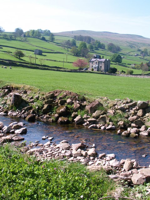
Friar Folds Hill is a prominent geographical feature located in Yorkshire, England. Classified as a hill, it is nestled within the picturesque landscapes of the Yorkshire Dales National Park. Rising to an elevation of approximately 450 meters (1,480 feet), Friar Folds Hill offers breathtaking panoramic views of the surrounding countryside.

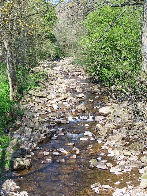
The hill is characterized by its gently sloping sides, which are covered in lush greenery during the warmer months. It is predominantly composed of sedimentary rock formations, including limestone and sandstone, which have been shaped by millions of years of erosion. This geological composition contributes to the diverse flora and fauna found on the hill, making it an important habitat for various plant and animal species.

Due to its accessibility and scenic beauty, Friar Folds Hill is a popular destination for outdoor enthusiasts and nature lovers. It offers numerous walking trails and paths, allowing visitors to explore the hill at their own pace. The hill is also a haven for bird watchers, as it attracts a wide variety of avian species, including peregrine falcons and red kites.

Furthermore, Friar Folds Hill holds historical significance in the region. It is believed to have been inhabited by humans since ancient times, with evidence of Bronze Age settlements discovered nearby. The hill's name is thought to be derived from the presence of a medieval friary that once stood in the vicinity.

Overall, Friar Folds Hill is a captivating natural landmark that showcases the beauty of Yorkshire's countryside and offers a rich tapestry of natural and historical features for visitors to explore and enjoy.

If you have any feedback on the listing, please let us know in the comments section below.

Friar Folds Hill Images

Images are sourced within 2km of 54.383456/-2.0550568 or Grid Reference SD9698. Thanks to Geograph Open Source API. All images are credited.

Ashpots Level Not marked on any map, this is a reasonably large spoil heap for a former lead mine. It is unknown whether it proved to be anything other than a trial, as there is no evidence on the heap other than limestone and a few bits of calcite.
Ashpots Level
Not marked on any map, this is a reasonably large spoil heap for a former lead mine. It is unknown whether it proved to be anything other than a trial, as there is no evidence on the heap other than limestone and a few bits of calcite.
Victoria Level One of just a handful of levels driven into the westside of Mill Gill by the Old Gang Company. It was by far the most successful, cutting Watersikes Vein and the Sun Vein in the 1860's, less than 5 years after the mine was begun. 
The end came, due to the fall in lead prices, in around 1887. This level was tried again in the late 1890's before closing in 1906, and it was cleaned out and repaired in 1924-26 by two men, but was found to contain no lead ore.
Victoria Level
One of just a handful of levels driven into the westside of Mill Gill by the Old Gang Company. It was by far the most successful, cutting Watersikes Vein and the Sun Vein in the 1860's, less than 5 years after the mine was begun. The end came, due to the fall in lead prices, in around 1887. This level was tried again in the late 1890's before closing in 1906, and it was cleaned out and repaired in 1924-26 by two men, but was found to contain no lead ore.
A row of Bouse Teams at Victoria Level Bouse: is the name for lead ore. It would have been brought out of the mine and tipped from a tub into one of these four Teams (a storage bay) before it was then taken by another tramway to the crushing floors and then on to the smelting mill. 
Rock & minerals that were of no value would have been run to the end of the spoil heap and tipped over.
A row of Bouse Teams at Victoria Level
Bouse: is the name for lead ore. It would have been brought out of the mine and tipped from a tub into one of these four Teams (a storage bay) before it was then taken by another tramway to the crushing floors and then on to the smelting mill. Rock & minerals that were of no value would have been run to the end of the spoil heap and tipped over.
Bridge over Ashpots Gutter This very finely crafted bridge, over what is quite frankly a tiddler of a stream, has been built for grouse shooting parties on the Gunnerside Estate, but is handily placed at the point where a PROW crosses the moor.
Bridge over Ashpots Gutter
This very finely crafted bridge, over what is quite frankly a tiddler of a stream, has been built for grouse shooting parties on the Gunnerside Estate, but is handily placed at the point where a PROW crosses the moor.
Groove of Ash Pot Gutter Ash Pot Gutter is a minor stream feeding water into Mill Gill, itself a tributary of the River Swale. The pale twigs are stems of dead heather, probably burnt by the owning estate as part of their management of the grouse moor; new growth is coming through.
Groove of Ash Pot Gutter
Ash Pot Gutter is a minor stream feeding water into Mill Gill, itself a tributary of the River Swale. The pale twigs are stems of dead heather, probably burnt by the owning estate as part of their management of the grouse moor; new growth is coming through.
Old Mill Dam at Ray Gill Built to supply a reliable source of water to High Mill, a much older smelt mill than the current remains at Old Gang, possibly dating from 1682.
The leat that supplied some of the water to the pond is still tracable across the hillside. The spring that develops into Ray Gill Beck would have supplied the rest of the water to the pond.
Old Mill Dam at Ray Gill
Built to supply a reliable source of water to High Mill, a much older smelt mill than the current remains at Old Gang, possibly dating from 1682. The leat that supplied some of the water to the pond is still tracable across the hillside. The spring that develops into Ray Gill Beck would have supplied the rest of the water to the pond.
Ruined Sheepfold Must have been a long time since a sheep was locked in here.
Ruined Sheepfold
Must have been a long time since a sheep was locked in here.
Ash Pot Gutter draining east from the Melbecks Moor track This track is obviously still of importance to someone long after the demise of lead mining on the moor which was the original raison d'être for most of the rights of way up here, since Ash Pot Gutter crosses it by a recent-looking and substantial concrete ford. There's maybe a quarter square kilometre of catchment at this point where a number of small sikes have coalesced to form a single stream which has only one tributary, on its right bank, all the way down to its confluence with Old Gang Beck a little over a kilometre from this point.
Ash Pot Gutter draining east from the Melbecks Moor track
This track is obviously still of importance to someone long after the demise of lead mining on the moor which was the original raison d'être for most of the rights of way up here, since Ash Pot Gutter crosses it by a recent-looking and substantial concrete ford. There's maybe a quarter square kilometre of catchment at this point where a number of small sikes have coalesced to form a single stream which has only one tributary, on its right bank, all the way down to its confluence with Old Gang Beck a little over a kilometre from this point.
Ruin, Knotts Hill A ruined wall.
Ruin, Knotts Hill
A ruined wall.
Small Pond, Knotts Hill This must be a man made pond.
Small Pond, Knotts Hill
This must be a man made pond.
Concrete ford through Ash Pot Gutter Barely a trickle of water today.
Concrete ford through Ash Pot Gutter
Barely a trickle of water today.
Two Small Tarns, Ash Pot Side
Shooters Track over Melbecks Moor
Ford :  Melbecks Moor Located on track from Moor House to Gunnerside.
Ford : Melbecks Moor
Located on track from Moor House to Gunnerside.
Ash Pot Gutter On Melbecks Moor, a network of tracks and a spoil tip of lead ore waste.
Ash Pot Gutter
On Melbecks Moor, a network of tracks and a spoil tip of lead ore waste.
Ash Pot Gutter Due to the dry start to the year there is no water flowing into Hard Level Gill.
Ash Pot Gutter
Due to the dry start to the year there is no water flowing into Hard Level Gill.
Haverdale beck and 'The Gables' Looking across the final section of Haverdale Beck towards The Gables Guest House, which was originally the vicarage for Melbecks parish. This seems a trifle odd as the house is within Grinton parish.
Haverdale beck and 'The Gables'
Looking across the final section of Haverdale Beck towards The Gables Guest House, which was originally the vicarage for Melbecks parish. This seems a trifle odd as the house is within Grinton parish.
Gunnerside Beck, from the bridge at Gunnerside
Show me another place!

Friar Folds Hill is located at Grid Ref: SD9698 (Lat: 54.383456, Lng: -2.0550568)

Division: North Riding

Administrative County: North Yorkshire

District: Richmondshire

Police Authority: North Yorkshire

What 3 Words

///work.provider.freshest. Near Bowes, Co. Durham

Related Wikis

Gunnerside

Gunnerside is a village in North Yorkshire, England. It is situated in Swaledale, on the B6270 road, 3 miles (5 km) east of Muker and 6 miles (10 km) west...

Melbecks

Melbecks is a civil parish in North Yorkshire, England. It is located in upper Swaledale and covers the settlements of Gunnerside, Low Row, Feetham and...

Low Row

Low Row is a village in Swaledale, in the Yorkshire Dales, North Yorkshire, England. It lies about 3 miles west of Reeth and is between Healaugh and Gunnerside...

Feetham

Feetham is a hamlet opposite Low Row in the Yorkshire Dales, North Yorkshire, England. The origin of the place-name is from Old Norse and means place at...

Crackpot, North Yorkshire

Crackpot is a village in Swaledale, North Yorkshire, England. Its name derives from the Old English kraka (crow) and the Viking word pot (usually a pit...

Satron

Satron is a hamlet in Swaledale, North Yorkshire, England. It lies 0.6 miles (1 km) south west of Gunnerside on the opposite bank of the River Swale. It...

Gunnerside Gill

Gunnerside Gill (or Ghyll) is a small valley in the Yorkshire Dales, England, which branches off Swaledale into moorland to the north of Gunnerside. The...

Ivelet

Ivelet is a hamlet in the Yorkshire Dales, North Yorkshire, England about a mile west of Gunnerside in Swaledale. Ivelet Bridge crosses the River Swale...

Nearby Amenities

Located within 500m of 54.383456,-2.0550568
Ford: yes
Lat/Long: 54.383957/-2.0617765
Stoops Rigg
Place: locality
Lat/Long: 54.3823442/-2.0575917
Ford: yes
Lat/Long: 54.3835471/-2.0623405
Barf End Gate
Place: locality
Source: OS OpenData StreetView (April 2016)
Lat/Long: 54.3831717/-2.0623468
Ford: yes
Lat/Long: 54.381965/-2.0520392
The data included in this document is from www.openstreetmap.org. The data is made available under ODbL.

Have you been to Friar Folds Hill?

Leave your review of Friar Folds Hill below (or comments, questions and feedback).