Pawston Hill

Hill, Mountain in Northumberland

England

Pawston Hill

Bridge parapet remains in perilous condition by the Bowmont Water The remains of the parapet on the north-east side of the former girder bridge over the Bowmont Water south of Mindrum Station on the former Alnwick and Cornhill Railway.  The bridge was structure 13 at four miles and one chain from Cornhill where the mileage and structure numbering commenced.  With thanks to Andy Brown for the information on this site.

This photograph was taken during the Coronavirus (COVID-19) pandemic of 2020/21/22.
Bridge parapet remains in perilous condition by the Bowmont Water Credit: James T M Towill

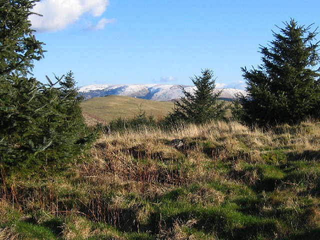
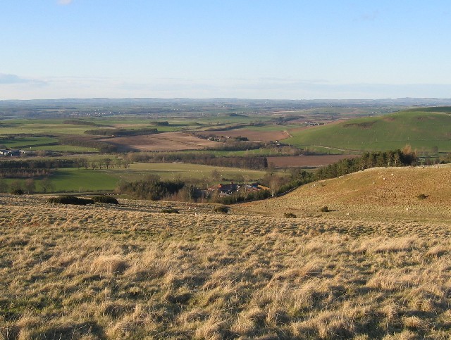
Pawston Hill is a prominent hill located in Northumberland, England. It is known for its stunning views of the surrounding countryside and is a popular destination for hikers and nature enthusiasts. The hill stands at an elevation of approximately 400 meters (1,312 feet) above sea level, making it one of the highest points in the region.

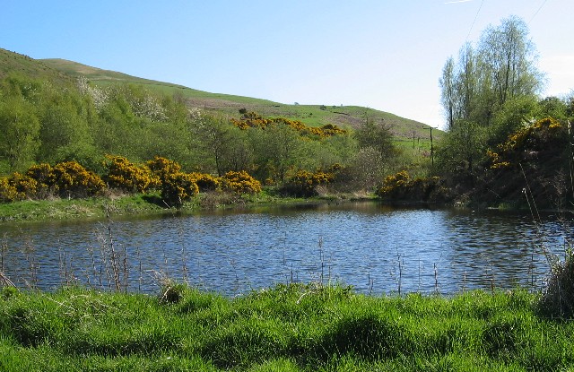
Pawston Hill is covered in lush green vegetation, including grasses, shrubs, and trees, providing a habitat for a variety of wildlife. The hill is also home to a diverse range of bird species, making it a great spot for birdwatching.

Visitors to Pawston Hill can enjoy a leisurely hike to the summit, where they will be rewarded with panoramic views of the rolling countryside below. On a clear day, it is possible to see as far as the North Sea in the east and the Cheviot Hills to the west.

Overall, Pawston Hill offers a peaceful and picturesque setting for outdoor recreation and exploration, making it a must-visit destination for those looking to experience the natural beauty of Northumberland.

If you have any feedback on the listing, please let us know in the comments section below.

Pawston Hill Images

Images are sourced within 2km of 55.58073/-2.2362241 or Grid Reference NT8531. Thanks to Geograph Open Source API. All images are credited.

Bridge parapet remains in perilous condition by the Bowmont Water The remains of the parapet on the north-east side of the former girder bridge over the Bowmont Water south of Mindrum Station on the former Alnwick and Cornhill Railway.  The bridge was structure 13 at four miles and one chain from Cornhill where the mileage and structure numbering commenced.  With thanks to Andy Brown for the information on this site.

This photograph was taken during the Coronavirus (COVID-19) pandemic of 2020/21/22.
Bridge parapet remains in perilous condition by the Bowmont Water
The remains of the parapet on the north-east side of the former girder bridge over the Bowmont Water south of Mindrum Station on the former Alnwick and Cornhill Railway. The bridge was structure 13 at four miles and one chain from Cornhill where the mileage and structure numbering commenced. With thanks to Andy Brown for the information on this site. This photograph was taken during the Coronavirus (COVID-19) pandemic of 2020/21/22.
Bridge parapet remains by the Bowmont Water Looking to the south bank of the Bowmont Water and the girder bridge parapet remains.  The bridge was structure 13 at four miles and one chain from Cornhill where the mileage and structure numbering commenced.  With thanks to Andy Brown for the information on this site.

This photograph was taken during the Coronavirus (COVID-19) pandemic of 2020/21/22.
Bridge parapet remains by the Bowmont Water
Looking to the south bank of the Bowmont Water and the girder bridge parapet remains. The bridge was structure 13 at four miles and one chain from Cornhill where the mileage and structure numbering commenced. With thanks to Andy Brown for the information on this site. This photograph was taken during the Coronavirus (COVID-19) pandemic of 2020/21/22.
A small weir in the Bowmont Water This small weir, apparently partially constructed of wood, was once under a girder bridge which crossed the Bowmont Water on the route of the former Alnwick and Cornhill Railway line here.  The bridge was structure 13 at four miles and one chain from Cornhill where the mileage and structure numbering commenced.  With thanks to Andy Brown for the information on this site.

This photograph was taken during the Coronavirus (COVID-19) pandemic of 2020/21/22.
A small weir in the Bowmont Water
This small weir, apparently partially constructed of wood, was once under a girder bridge which crossed the Bowmont Water on the route of the former Alnwick and Cornhill Railway line here. The bridge was structure 13 at four miles and one chain from Cornhill where the mileage and structure numbering commenced. With thanks to Andy Brown for the information on this site. This photograph was taken during the Coronavirus (COVID-19) pandemic of 2020/21/22.
Gates by the former railway These gates would appear to date from when the Alnwick and Cornhill Railway was in operation and are beside the site of the former girder bridge which spanned the Bowmont Water here.  The bridge was structure 13 at four miles and one chain from Cornhill where the mileage and structure numbering commenced.  With thanks to Andy Brown for the information on this site.

This photograph was taken during the Coronavirus (COVID-19) pandemic of 2020/21/22.
Gates by the former railway
These gates would appear to date from when the Alnwick and Cornhill Railway was in operation and are beside the site of the former girder bridge which spanned the Bowmont Water here. The bridge was structure 13 at four miles and one chain from Cornhill where the mileage and structure numbering commenced. With thanks to Andy Brown for the information on this site. This photograph was taken during the Coronavirus (COVID-19) pandemic of 2020/21/22.
Bridge parapet remains by the Bowmont Water near Mindrum Station A view of the upstream faces of the bridge parapet remains either side of the Bowmont Water.  The bridge was structure 13 at four miles and one chain from Cornhill where the mileage and structure numbering commenced.  With thanks to Andy Brown for the information on this site.

This photograph was taken during the Coronavirus (COVID-19) pandemic of 2020/21/22.
Bridge parapet remains by the Bowmont Water near Mindrum Station
A view of the upstream faces of the bridge parapet remains either side of the Bowmont Water. The bridge was structure 13 at four miles and one chain from Cornhill where the mileage and structure numbering commenced. With thanks to Andy Brown for the information on this site. This photograph was taken during the Coronavirus (COVID-19) pandemic of 2020/21/22.
Embankment and bridge parapet remains by the Bowmont Water This photograph has been taken on the north side of the Bowmont Water.  The bridge was structure 13 at four miles and one chain from Cornhill where the mileage and structure numbering commenced.  With thanks to Andy Brown for the information on this site.

This photograph was taken during the Coronavirus (COVID-19) pandemic of 2020/21/22.
Embankment and bridge parapet remains by the Bowmont Water
This photograph has been taken on the north side of the Bowmont Water. The bridge was structure 13 at four miles and one chain from Cornhill where the mileage and structure numbering commenced. With thanks to Andy Brown for the information on this site. This photograph was taken during the Coronavirus (COVID-19) pandemic of 2020/21/22.
The remains of a railway embankment by the Bowmont Water south of Mindrum Station The embankment is accessed via a walk around the perimeter of an arable field.  

This photograph was taken during the Coronavirus (COVID-19) pandemic of 2020/21/22.
The remains of a railway embankment by the Bowmont Water south of Mindrum Station
The embankment is accessed via a walk around the perimeter of an arable field. This photograph was taken during the Coronavirus (COVID-19) pandemic of 2020/21/22.
Field, Bowmont Hill Farm and Bowmont Hill
Hare Law Approaching the top of Hare Law
Hare Law
Approaching the top of Hare Law
Hare Law Looking south from the top of Hare Law to the Cheviot.
Hare Law
Looking south from the top of Hare Law to the Cheviot.
Whaup Moor Looking south
Whaup Moor
Looking south
Looking NE from the east end of Pawston Hill The high ground on the left skyline is Moneylaws Hill
Looking NE from the east end of Pawston Hill
The high ground on the left skyline is Moneylaws Hill
North from Pawston Hill
The Bowmont Looking North over the Bowmont towards Mindrom Mill (white buildings rightmost)
The Bowmont
Looking North over the Bowmont towards Mindrom Mill (white buildings rightmost)
Bowmont Valley Looking NE
Bowmont Valley
Looking NE
Bowmont Valley Looking SW up the Bowmont valley towards Yetholm
Bowmont Valley
Looking SW up the Bowmont valley towards Yetholm
Pawston Lake Looking North over this small lake which is central to this grid square.
Pawston Lake
Looking North over this small lake which is central to this grid square.
Northern Cheviots Looking south over this grid square towards Hare Law, with Coldsmouth being the dominant hill on the left. (Pawston Lake is hidden in the valley below)
A view so typical of the beautiful Borders countryside!
Northern Cheviots
Looking south over this grid square towards Hare Law, with Coldsmouth being the dominant hill on the left. (Pawston Lake is hidden in the valley below) A view so typical of the beautiful Borders countryside!
Show me another place!

Pawston Hill is located at Grid Ref: NT8531 (Lat: 55.58073, Lng: -2.2362241)

Unitary Authority: Northumberland

Police Authority: Northumbria

What 3 Words

///motive.playful.topped. Near Kirknewton, Northumberland

Nearby Locations

Pawston Lake Pawston Hill

Related Wikis

Mindrum

Mindrum is a village in Northumberland, England, in the district of Berwick-upon-Tweed. Now little more than a postal address, it forms the centre of a...

Mindrum railway station

Mindrum railway station was a stone built railway station serving the hamlet of Mindrum and the surrounding villages in Northumberland. It was on the Alnwick...

Kilham, Northumberland

Kilham is a hamlet and civil parish in the English county of Northumberland, located 8.0 miles (12.9 km) west of Wooler, 12.0 miles (19.3 km) east of Kelso...

Yetholm

Yetholm is the parish that contained the villages of Kirk Yetholm and Town Yetholm in the east of the former county of Roxburghshire, nowadays in the Scottish...

Nearby Amenities

Located within 500m of 55.58073,-2.2362241
Pawston Hill
Natural: peak
Lat/Long: 55.5806343/-2.2361158
The data included in this document is from www.openstreetmap.org. The data is made available under ODbL.

Have you been to Pawston Hill?

Leave your review of Pawston Hill below (or comments, questions and feedback).