Ox Hill

Hill, Mountain in Worcestershire Malvern Hills

England

Ox Hill

Poolbrook in Malvern Mid-December and the trees at Poolbrook in Malvern are now bare.
Poolbrook in Malvern Credit: Philip Halling

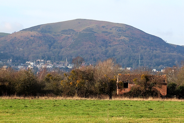
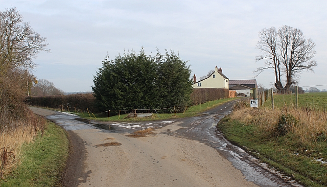
Ox Hill is a prominent geographical feature located in Worcestershire, England. As its name suggests, it is a hill or small mountain that stands at an elevation of approximately 300 meters (984 feet) above sea level. The hill is situated in the western part of Worcestershire, near the border with Herefordshire.

Ox Hill is characterized by its gently sloping sides and distinctive rounded shape, typical of many hills in the region. The hill is primarily composed of sedimentary rocks, which have been shaped over millions of years by natural processes such as erosion and weathering.

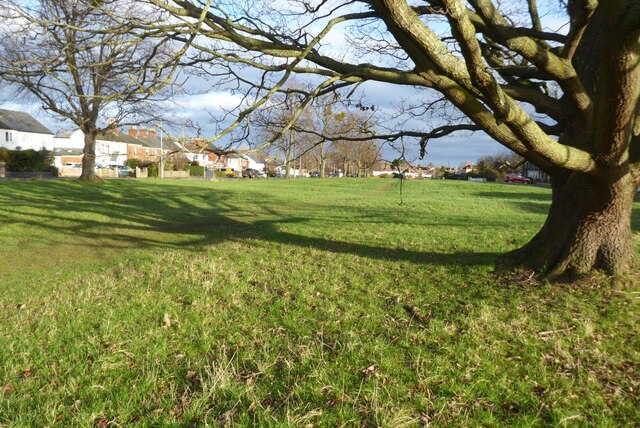
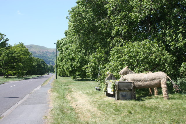
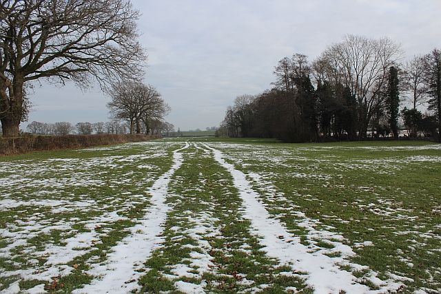
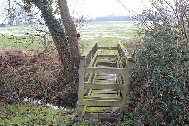
The area surrounding Ox Hill is known for its picturesque beauty, boasting stunning panoramic views of the Worcestershire countryside. The hill is covered in lush green vegetation, including grasslands, shrubs, and scattered patches of woodland. It is also home to a variety of wildlife, such as rabbits, foxes, and various bird species.

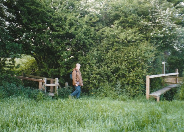
Ox Hill attracts hikers and nature enthusiasts who enjoy exploring its slopes and trails. There are several footpaths that lead to the summit, offering visitors the opportunity to experience the stunning vistas from the top. The hill is also a popular spot for picnics and photography, providing a peaceful escape from the hustle and bustle of urban life.

Overall, Ox Hill is an important natural landmark in Worcestershire, offering both recreational opportunities and a chance to immerse oneself in the region's natural beauty.

If you have any feedback on the listing, please let us know in the comments section below.

Ox Hill Images

Images are sourced within 2km of 52.098897/-2.2853512 or Grid Reference SO8044. Thanks to Geograph Open Source API. All images are credited.

Poolbrook in Malvern Mid-December and the trees at Poolbrook in Malvern are now bare.
Poolbrook in Malvern
Mid-December and the trees at Poolbrook in Malvern are now bare.
Footbridges at the junction of footpaths near Blackmore End
Minor road on the northern edge of Guarlford
MSPCA trough - Well Dressing 2011 - Togetherness The trough, erected at the beginning of the 20th century by the Malvern Society for the Prevention of Cruelty to Animals as a memorial to the horses who suffered in the Boer War, has been decorated by a team led by Stephanie Underwood-Webb. 
Begun as a solo venture it soon became a community project and has been rewarded with a Gold Award.
"You aren't a proper couple until you understand everything the other hasn't said." 
The trough used to be located on the large oddly shaped traffic island in Barnards Green shopping area, but has been at this position, by the Guarlford straight for many decades.
Worcestershire Beacon is in the distance.
<a href="https://www.geograph.org.uk/photo/2395889">SO7945 : MSPCA trough - Well Dressing 2011 - Togetherness</a>
MSPCA trough - Well Dressing 2011 - Togetherness
The trough, erected at the beginning of the 20th century by the Malvern Society for the Prevention of Cruelty to Animals as a memorial to the horses who suffered in the Boer War, has been decorated by a team led by Stephanie Underwood-Webb. Begun as a solo venture it soon became a community project and has been rewarded with a Gold Award. "You aren't a proper couple until you understand everything the other hasn't said." The trough used to be located on the large oddly shaped traffic island in Barnards Green shopping area, but has been at this position, by the Guarlford straight for many decades. Worcestershire Beacon is in the distance. SO7945 : MSPCA trough - Well Dressing 2011 - Togetherness
MSPCA trough - Well Dressing 2011 - Togetherness The trough, erected at the beginning of the 20th century by the Malvern Society for the Prevention of Cruelty to Animals as a memorial to the horses who suffered in the Boer War, has been decorated by a team led by Stephanie Underwood-Webb. 
Begun as a solo venture it soon became a community project and has been rewarded with a Gold Award.

"And so we stand together,
The horses, thee and me,
As the beasts take sips from the old stone trough
The world turns, quietly."

<a href="https://www.geograph.org.uk/photo/2395867">SO7945 : MSPCA trough - Well Dressing 2011 - Togetherness</a>
MSPCA trough - Well Dressing 2011 - Togetherness
The trough, erected at the beginning of the 20th century by the Malvern Society for the Prevention of Cruelty to Animals as a memorial to the horses who suffered in the Boer War, has been decorated by a team led by Stephanie Underwood-Webb. Begun as a solo venture it soon became a community project and has been rewarded with a Gold Award. "And so we stand together, The horses, thee and me, As the beasts take sips from the old stone trough The world turns, quietly." SO7945 : MSPCA trough - Well Dressing 2011 - Togetherness
The Swan Pool (village pond) at sunset
The Swan Inn at Hanley Swan Perhaps the title should be "the swan" as the signs use lower case only.  Hanley Swan has the traditional English village centre: a cross roads with a village green, overlooked by an inn in one corner; a village pond in the next corner; the post office and shop next, and houses in the fourth.  When I grew up here, I almost believed that every village should have this layout.
The Swan Inn at Hanley Swan
Perhaps the title should be "the swan" as the signs use lower case only. Hanley Swan has the traditional English village centre: a cross roads with a village green, overlooked by an inn in one corner; a village pond in the next corner; the post office and shop next, and houses in the fourth. When I grew up here, I almost believed that every village should have this layout.
A second oak tree on the village green The centre of the green is site for an oak planted in the 19th century.
A second oak tree on the village green
The centre of the green is site for an oak planted in the 19th century.
Barnards Close, Great Malvern
Old Barn, Guarlford A derelict building amongst an apple orchard with a good crop of mistletoe.
In the background is North Hill at the end of the granite Malvern Hills range with Great Malvern beneath.
The church spire to the left of centre is Holly Mount United Reformed Church.
The infill television transmitter is to the right of the picture.
This also transmits local radio and the structure is adorned with a plethora of aerials and microwave dishes.
Old Barn, Guarlford
A derelict building amongst an apple orchard with a good crop of mistletoe. In the background is North Hill at the end of the granite Malvern Hills range with Great Malvern beneath. The church spire to the left of centre is Holly Mount United Reformed Church. The infill television transmitter is to the right of the picture. This also transmits local radio and the structure is adorned with a plethora of aerials and microwave dishes.
Hangman's Lane - Green Lane junction Hangmans Lane forks to the left while the lane to the right becomes an unmetalled "green lane" after Broadacres Farm.
Hangman's Lane - Green Lane junction
Hangmans Lane forks to the left while the lane to the right becomes an unmetalled "green lane" after Broadacres Farm.
Snow field, Hanley Swan An interesting long narrow field with a stream on the right hand boundary.
Snow field, Hanley Swan
An interesting long narrow field with a stream on the right hand boundary.
Snow field, Hanley Swan An interesting long narrow field with a stream bordering its southern edge.
The Malvern Hills can be seen in the distance.
Snow field, Hanley Swan
An interesting long narrow field with a stream bordering its southern edge. The Malvern Hills can be seen in the distance.
Wooden Bridge near Hanley Swan Attached to the tree on the far side is a maple leaf memorial to Canadians killed in a mid air collision during WWII.
<a href="https://www.geograph.org.uk/photo/2806694">SO8243 : Footbridge and Maple Leaf memorial, Hanley Swan</a>
Wooden Bridge near Hanley Swan
Attached to the tree on the far side is a maple leaf memorial to Canadians killed in a mid air collision during WWII. SO8243 : Footbridge and Maple Leaf memorial, Hanley Swan
Canadian memorial near Hanley Swan In memory of the seven Canadian airmen who died in a mid-air collision between two Wellington bombers on the 11th August 1944.
<a href="https://www.geograph.org.uk/photo/2806687">SO8243 : Names on the Canadian War Memorial, Hanley Swan</a>
<a href="https://www.geograph.org.uk/photo/2806673">SO8243 : Plaque on the Canadian War Memorial, Hanley Swan</a>
<a href="https://www.geograph.org.uk/photo/2806694">SO8243 : Footbridge and Maple Leaf memorial, Hanley Swan</a>
Canadian memorial near Hanley Swan
In memory of the seven Canadian airmen who died in a mid-air collision between two Wellington bombers on the 11th August 1944. SO8243 : Names on the Canadian War Memorial, Hanley Swan SO8243 : Plaque on the Canadian War Memorial, Hanley Swan SO8243 : Footbridge and Maple Leaf memorial, Hanley Swan
Plaque on the Canadian War Memorial, Hanley Swan Dedicated to the memory of seven
Canadian airmen who lost their lives
as a result of a mid-air collision
between two Wellington bombers on the
11th August 1944.
Wellington MF 591 struggled back to base at
Honeybourne.
Wellington LP 618 crashed in a field near
Hanley Swan. Only the pilot survived.

<a href="https://www.geograph.org.uk/photo/2806694">SO8243 : Footbridge and Maple Leaf memorial, Hanley Swan</a>
Plaque on the Canadian War Memorial, Hanley Swan
Dedicated to the memory of seven Canadian airmen who lost their lives as a result of a mid-air collision between two Wellington bombers on the 11th August 1944. Wellington MF 591 struggled back to base at Honeybourne. Wellington LP 618 crashed in a field near Hanley Swan. Only the pilot survived. SO8243 : Footbridge and Maple Leaf memorial, Hanley Swan
Names on the Canadian War Memorial, Hanley Swan The plaque lists the Canadian airmen who died in the two colliding Wellington bombers under the serial number of the planes:

MF 591
P.O. J. Shwaikoski. aged 30

LP618
Sgt. L.M Lysak. aged 31
Sgt. A.E. Kidney. aged 26
Sgt. G.O. Prime. aged 24
Sgt. L.C. Lamb. aged 24
Sgt. H.G. Round. aged 21
Sgt. L.H. Fraser. aged 20

We will remember them.

<a href="https://www.geograph.org.uk/photo/2806694">SO8243 : Footbridge and Maple Leaf memorial, Hanley Swan</a>
Names on the Canadian War Memorial, Hanley Swan
The plaque lists the Canadian airmen who died in the two colliding Wellington bombers under the serial number of the planes: MF 591 P.O. J. Shwaikoski. aged 30 LP618 Sgt. L.M Lysak. aged 31 Sgt. A.E. Kidney. aged 26 Sgt. G.O. Prime. aged 24 Sgt. L.C. Lamb. aged 24 Sgt. H.G. Round. aged 21 Sgt. L.H. Fraser. aged 20 We will remember them. SO8243 : Footbridge and Maple Leaf memorial, Hanley Swan
Footbridge and Maple Leaf memorial, Hanley Swan The memorial is to the Canadian airmen who died from a mid air collision during WWII.
<a href="https://www.geograph.org.uk/photo/2806661">SO8243 : Canadian memorial near Hanley Swan</a>
<a href="https://www.geograph.org.uk/photo/2806673">SO8243 : Plaque on the Canadian War Memorial, Hanley Swan</a>
<a href="https://www.geograph.org.uk/photo/2806687">SO8243 : Names on the Canadian War Memorial, Hanley Swan</a>
Footbridge and Maple Leaf memorial, Hanley Swan
Show me another place!

Ox Hill is located at Grid Ref: SO8044 (Lat: 52.098897, Lng: -2.2853512)

Administrative County: Worcestershire

District: Malvern Hills

Police Authority: West Mercia

What 3 Words

///hype.flows.serenade. Near Great Malvern, Worcestershire

Related Wikis

Guarlford

Guarlford is a village and civil parish in the Malvern Hills district in the county of Worcestershire, England. The parish population was 261 in 2021.It...

Poolbrook

Poolbrook is a village and a suburb of Malvern, Worcestershire, England, situated approximately 1.5 miles (2.4 km) southeast of Great Malvern, the town...

The Chase School

The Chase School is a secondary school (ages 11–18) in Malvern, Worcestershire, England. The school opened as a Secondary Modern in 1953 under headteacher...

British National Fencing Museum

The British National Fencing Museum is the national museum for Great Britain for the sport and martial art of fencing.The museum opened during the year...
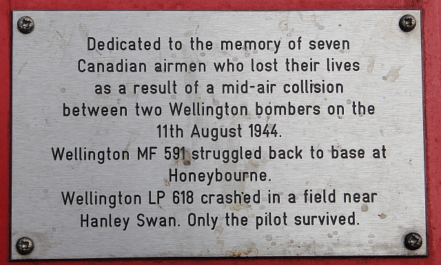
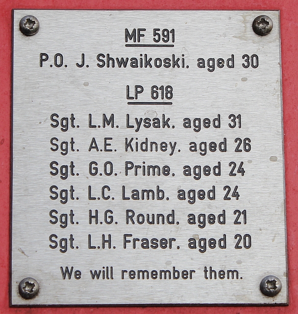
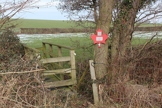
Hanley Swan

Hanley Swan is a small village in the English county of Worcestershire. It lies in the Malvern Hills district, between the towns of Malvern (two miles...

Malvern Hills Science Park

Malvern Hills Science Park is located on a 10 acre (4 Hectare) site in the Barnards Green suburb of Malvern, Worcestershire, England. It is a partnership...

Barnards Green

Barnards Green is one of the main population areas of Malvern, Worcestershire, England, situated approximately 1 mile (1.6 km) east and downhill from Great...

HMS Duke (shore establishment)

HMS Duke was a Royal Naval shore establishment based in Great Malvern, off St Andrews Road. It was commissioned on 27 May 1941, and by May 1943 it was...

Related Videos

Malvern Hills Club site

A large site with views of the nearby Malvern Hills and ideally located for a host of attractions in the surrounding area. As well as ...

Escape To Malvern Hills CAMC: A Dog-friendly Weekend Getaway!

Some weekends are meant for relaxing and this weekend at Malvern Hills caravan and motorhome club site was one of those.

The Annex Self-Catering, dog-friendly accommodation at Orchard Side Bed and Breakfast.

https://orchardsidehanleyswan.co.uk/self-catering-accommodation/ Welcome to The Annex self-catering, dog-friendly, ...

Cycle from Malvern Hills Club site

Jonathan Manning avoids the steepest of climbs as he navigates a picturesque route through the lower slopes of the Malvern Hills ...

Nearby Amenities

Located within 500m of 52.098897,-2.2853512
Barrier: stile
Lat/Long: 52.097914/-2.288255
Barrier: stile
Lat/Long: 52.0992548/-2.2894122
Barrier: stile
Lat/Long: 52.1020669/-2.2899117
Bench
Lat/Long: 52.0978463/-2.2880305
Barrier: stile
Lat/Long: 52.0992972/-2.2894505
Highfield Organic Farm - Trans
Power: pole
Transformer: distribution
Voltage Primary: 11000
Lat/Long: 52.1006219/-2.2802988
Power: pole
Lat/Long: 52.1005206/-2.279022
Power: pole
Lat/Long: 52.0947198/-2.2838607
Power: pole
Lat/Long: 52.0945884/-2.2832928
Power: pole
Lat/Long: 52.0954765/-2.28407
Power: pole
Lat/Long: 52.0949002/-2.2847325
Power: pole
Lat/Long: 52.0963758/-2.2818987
Power: pole
Lat/Long: 52.0958461/-2.2836683
Power: pole
Lat/Long: 52.0961258/-2.282751
Power: pole
Lat/Long: 52.0972796/-2.2824077
Blackmore Cottages
Power: pole
Transformer: distribution
Voltage Primary: 11000
Lat/Long: 52.0973307/-2.2824472
The data included in this document is from www.openstreetmap.org. The data is made available under ODbL.

Have you been to Ox Hill?

Leave your review of Ox Hill below (or comments, questions and feedback).