Bardon Mill

Settlement in Northumberland

England

Bardon Mill

Footbridge across the South Tyne near Bardon Mill
Footbridge across the South Tyne near Bardon Mill Credit: Clive Nicholson

Bardon Mill is a small village located in the county of Northumberland, England. Situated approximately 10 miles to the west of Hexham, it lies along the River South Tyne and is nestled within the picturesque North Pennines Area of Outstanding Natural Beauty.

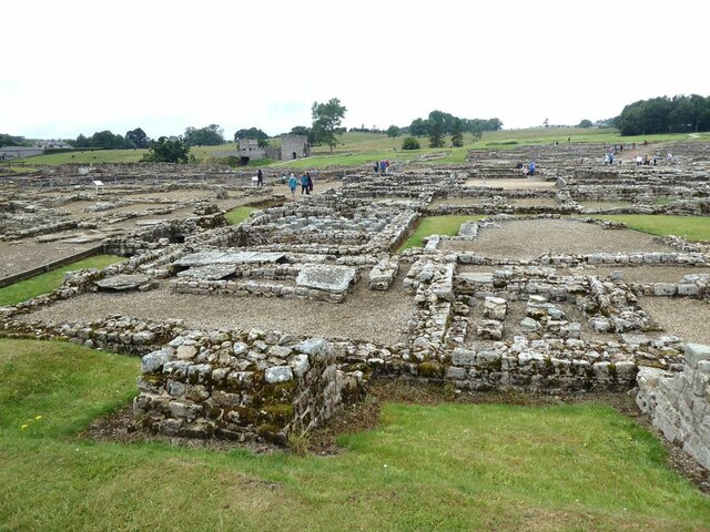
With a population of around 700 residents, Bardon Mill is a close-knit community that offers a quiet and peaceful environment. The village is surrounded by stunning countryside, providing ample opportunities for outdoor activities such as hiking, biking, and fishing. The nearby Hadrian's Wall, a UNESCO World Heritage Site, is a popular attraction for both locals and tourists, offering a glimpse into the area's rich history.

Bardon Mill is well-served by amenities, including a village shop, post office, and a public house. The village also boasts its own primary school, providing education for children in the local area. There is a strong sense of community spirit in Bardon Mill, with various events and gatherings organized throughout the year, bringing residents together.

Transport links in Bardon Mill are convenient, with a train station providing easy access to Newcastle and Carlisle. The A69 road passes through the village, connecting it to nearby towns and cities.

Overall, Bardon Mill offers a tranquil and idyllic setting, perfect for those seeking a peaceful countryside lifestyle while still enjoying the convenience of nearby amenities and attractions.

If you have any feedback on the listing, please let us know in the comments section below.

Bardon Mill Images

Images are sourced within 2km of 54.975879/-2.347223 or Grid Reference NY7764. Thanks to Geograph Open Source API. All images are credited.

Footbridge across the South Tyne near Bardon Mill
Roman vicus at Vindolanda Vindolanda was a Roman auxiliary fort (castrum) just south of Hadrian's Wall in Northumberland. Located near the modern village of Bardon Mill, it guarded the Stanegate, the Roman road from the River Tyne to the Solway Firth. It is noted for the Vindolanda Tablets, among the most important finds of military and private correspondence (written with ink on wooden tablets) found anywhere in the Roman Empire.
Wikipedia: <span class="nowrap"><a title="http://en.wikipedia.org/wiki/Vindolanda" rel="nofollow ugc noopener" href="http://en.wikipedia.org/wiki/Vindolanda">Link</a><img style="margin-left:2px;" alt="External link" title="External link - shift click to open in new window" src="https://s1.geograph.org.uk/img/external.png" width="10" height="10"/></span> <span class="nowrap"><a title="http://en.wikipedia.org/wiki/Vindolanda_tablets" rel="nofollow ugc noopener" href="http://en.wikipedia.org/wiki/Vindolanda_tablets">Link</a><img style="margin-left:2px;" alt="External link" title="External link - shift click to open in new window" src="https://s1.geograph.org.uk/img/external.png" width="10" height="10"/></span>


The British Museum Top 10 British Treasures: <span class="nowrap"><a title="http://www.britishmuseum.org/explore/online_tours/britain/our_top_ten_british_treasures/the_vindolanda_tablets.aspx" rel="nofollow ugc noopener" href="http://www.britishmuseum.org/explore/online_tours/britain/our_top_ten_british_treasures/the_vindolanda_tablets.aspx">Link</a><img style="margin-left:2px;" alt="External link" title="External link - shift click to open in new window" src="https://s1.geograph.org.uk/img/external.png" width="10" height="10"/></span>
Vindolanda Tablets online: <span class="nowrap"><a title="http://vindolanda.csad.ox.ac.uk/index.shtml" rel="nofollow ugc noopener" href="http://vindolanda.csad.ox.ac.uk/index.shtml">Link</a><img style="margin-left:2px;" alt="External link" title="External link - shift click to open in new window" src="https://s1.geograph.org.uk/img/external.png" width="10" height="10"/></span>
Vindolanda Charitable Trust: <span class="nowrap"><a title="http://www.vindolanda.com/Home.htm" rel="nofollow ugc noopener" href="http://www.vindolanda.com/Home.htm">Link</a><img style="margin-left:2px;" alt="External link" title="External link - shift click to open in new window" src="https://s1.geograph.org.uk/img/external.png" width="10" height="10"/></span>
Vindolanda on BBC: <span class="nowrap"><a title="http://www.bbc.co.uk/history/ancient/romans/vindolanda_01.shtml" rel="nofollow ugc noopener" href="http://www.bbc.co.uk/history/ancient/romans/vindolanda_01.shtml">Link</a><img style="margin-left:2px;" alt="External link" title="External link - shift click to open in new window" src="https://s1.geograph.org.uk/img/external.png" width="10" height="10"/></span>
A Digger's Guide to Vindolanda: <span class="nowrap"><a title="http://s9.zetaboards.com/We_Dig_Vindolanda/pages/diggers_guide/" rel="nofollow ugc noopener" href="http://s9.zetaboards.com/We_Dig_Vindolanda/pages/diggers_guide/">Link</a><img style="margin-left:2px;" alt="External link" title="External link - shift click to open in new window" src="https://s1.geograph.org.uk/img/external.png" width="10" height="10"/></span>
Roman Britain: <span class="nowrap"><a title="http://www.roman-britain.org/places/vindolanda.htm" rel="nofollow ugc noopener" href="http://www.roman-britain.org/places/vindolanda.htm">Link</a><img style="margin-left:2px;" alt="External link" title="External link - shift click to open in new window" src="https://s1.geograph.org.uk/img/external.png" width="10" height="10"/></span>
Northumberland Tales: <span class="nowrap"><a title="http://www.northumberland-tales.com/Vindolanda.html" rel="nofollow ugc noopener" href="http://www.northumberland-tales.com/Vindolanda.html">Link</a><img style="margin-left:2px;" alt="External link" title="External link - shift click to open in new window" src="https://s1.geograph.org.uk/img/external.png" width="10" height="10"/></span>
Roman vicus at Vindolanda
Vindolanda was a Roman auxiliary fort (castrum) just south of Hadrian's Wall in Northumberland. Located near the modern village of Bardon Mill, it guarded the Stanegate, the Roman road from the River Tyne to the Solway Firth. It is noted for the Vindolanda Tablets, among the most important finds of military and private correspondence (written with ink on wooden tablets) found anywhere in the Roman Empire. Wikipedia: LinkExternal link LinkExternal link The British Museum Top 10 British Treasures: LinkExternal link Vindolanda Tablets online: LinkExternal link Vindolanda Charitable Trust: LinkExternal link Vindolanda on BBC: LinkExternal link A Digger's Guide to Vindolanda: LinkExternal link Roman Britain: LinkExternal link Northumberland Tales: LinkExternal link
Vindolanda Roman Fort Prehistoric circular buildings overlain by a later Roman wall.
Vindolanda Roman Fort
Prehistoric circular buildings overlain by a later Roman wall.
Houses on Millfield Court, Bardon Mill
Pond near railway
Pond near railway
Cattle between railway and River South Tyne And across the river is Crow Hall.
Cattle between railway and River South Tyne
And across the river is Crow Hall.
Bardon Mill Station looking west
Vindolanda : archaeologists' wheelbarrows
Allen Banks : view over Ridley Hall
Vindolanda : archaeologists at work
Archaeologists at work at Vindolanda Roman Fort Volunteers on the dig can be readily identified by their purple T-shirts. In the background, a replica Roman fort.
Archaeologists at work at Vindolanda Roman Fort
Volunteers on the dig can be readily identified by their purple T-shirts. In the background, a replica Roman fort.
Round houses at Vindolanda The remains of round houses dating from the early years of the fort, near the North Gate.
Round houses at Vindolanda
The remains of round houses dating from the early years of the fort, near the North Gate.
Sixteen-seater loo! At the south-east corner of Vindolanda Roman Fort.
Sixteen-seater loo!
At the south-east corner of Vindolanda Roman Fort.
General view of Vindolanda Roman Fort The impressive and extensive remains of the Roman Fort. A replica fort can be seen in the middle distance.
General view of Vindolanda Roman Fort
The impressive and extensive remains of the Roman Fort. A replica fort can be seen in the middle distance.
Roman war memorial at Vindolanda Memorial to the troops who served at this outpost of the Roman Empire. The cohorts and legions who served here are listed.
Roman war memorial at Vindolanda
Memorial to the troops who served at this outpost of the Roman Empire. The cohorts and legions who served here are listed.
Chesterholm The buildings nestling in the valley of the Chainley Burn on the eastern edge of Vindolana house the museum, cafe and offices of the Vindolanda Trust.
Chesterholm
The buildings nestling in the valley of the Chainley Burn on the eastern edge of Vindolana house the museum, cafe and offices of the Vindolanda Trust.
Replica pottery at Vindolanda
"Fireball" sculpture at Vindolanda This sculpture commemorates the finding by Robin Birtley, pioneering archaeologist, of the partly-charred remains from a bonfire of Roman army paperwork dating from AD105. The firepit is ceremonially lit once a year.
"Fireball" sculpture at Vindolanda
This sculpture commemorates the finding by Robin Birtley, pioneering archaeologist, of the partly-charred remains from a bonfire of Roman army paperwork dating from AD105. The firepit is ceremonially lit once a year.
Show me another place!

Bardon Mill is located at Grid Ref: NY7764 (Lat: 54.975879, Lng: -2.347223)

Unitary Authority: Northumberland

Police Authority: Northumbria

What 3 Words

///seriously.doghouse.yummy. Near Bardon Mill, Northumberland

Related Wikis

Bardon Mill railway station

Bardon Mill is a railway station on the Tyne Valley Line, which runs between Newcastle and Carlisle via Hexham. The station, situated 27 miles 54 chains...

Redburn, Northumberland

Redburn is a village in Northumberland, England about 0.5 miles (0.80 km) west of Bardon Mill. It is situated about 4 miles (6 km) south of Hadrian's Wall...

Bardon Mill

Bardon Mill is a small village in Northumberland, within the vicinity of the ancient Hadrian's Wall. It is located around 10+1⁄2 miles (17 kilometres)...

Beltingham River Shingle

Beltingham River Shingle is the name given to a Site of Special Scientific Interest (SSSI) in Northumberland in the north-east of England, notable for...

Beltingham

Beltingham is a small village on the River South Tyne in Northumberland, in England. It is situated 1 mile (2 km) southeast of Bardon Mill and 10 miles...

Henshaw, Northumberland

Henshaw is a small village and civil parish in Northumberland, within the vicinity of the ancient Hadrian's Wall. It is located around 11.5 miles (19 km...

A69 road

The A69 is a major northern trunk road in England, running east–west across the Pennines, through the counties of Tyne and Wear, Northumberland and Cumbria...

Ridley Hall, Northumberland

Ridley Hall is an 18th-century country house, now a residential and conference centre, at Bardon Mill, Northumberland. It is a Grade II listed building...

Nearby Amenities

Located within 500m of 54.975879,-2.347223
Bardon Mill
Public Transport: stop_position
Train: yes
Lat/Long: 54.9745512/-2.344913
Crossing Barrier: no
Railway: level_crossing
Lat/Long: 54.9744714/-2.3431325
Bus Stop
Naptan AtcoCode: 3100Y781646
Naptan NaptanCode: nldagtmd
Lat/Long: 54.9755686/-2.3428377
Bardon Mill Pottery
Man Made: works
Lat/Long: 54.9759942/-2.347335
Post Box
Operator: Royal Mail
Ref: NE47 57
Lat/Long: 54.9759106/-2.3477503
Cafe
Bardon Mill Village Store
Addr City: Hexham
Addr County: Northumberland
Addr Postcode: NE47 7HX
Addr Suburb: Bardon Mill
Fhrs Id: 520806
Opening Hours: Mo,We 08:00-14:00; Tu,Th,Fr 08:00-17:00; PH,Sa,Su 10:00-16:00
Outdoor Seating: yes
Shop: convenience
Lat/Long: 54.9758786/-2.3478308
War memorial
Historic: memorial
Lat/Long: 54.9756586/-2.3463399
Noexit: yes
Lat/Long: 54.9792143/-2.3462857
Noexit: yes
Lat/Long: 54.9791325/-2.3453961
Noexit: yes
Lat/Long: 54.9792117/-2.34544
Hawthorn Cottage Industry
Source: local knowledge
Tourism: attraction
Lat/Long: 54.9761316/-2.346781
Bardon Mill
Public Transport: stop_position
Train: yes
Lat/Long: 54.9745349/-2.3452187
Crossing Barrier: no
Railway: level_crossing
Lat/Long: 54.9744362/-2.3431599
Bardon Mill
Addr City: Hexham
Addr Postcode: NE47 7HY
Addr Suburb: Bardon Mill
Naptan AtcoCode: 9100BRDNML
Network: National Rail
Network Website: https://www.nationalrail.co.uk/stations/bll/
Network Wikidata: Q26334
Operator: Northern
Operator Website: https://www.northernrailway.co.uk/stations/bardon-mill
Operator Wikidata: Q85789775
Public Transport: station
Railway: station
Ref Crs: BLL
Wheelchair: yes
Wikidata: Q2052953
Wikipedia: en:Bardon Mill railway station
Lat/Long: 54.9745437/-2.3450711
Bicycle Parking
Bicycle Parking: lockers
Capacity: 4
Lat/Long: 54.9746778/-2.34669
Barrier: bollard
Bicycle: yes
Foot: yes
Lat/Long: 54.9746985/-2.3466264
Parking
Access: customers
Capacity: 5
Parking: surface
Lat/Long: 54.974693/-2.3469426
Power: pole
Lat/Long: 54.9769239/-2.3400154
Power: pole
Lat/Long: 54.9764082/-2.3421531
Power: pole
Lat/Long: 54.9764067/-2.3426949
Power: pole
Lat/Long: 54.9770147/-2.3455327
Power: pole
Lat/Long: 54.9770363/-2.3473379
Power: pole
Lat/Long: 54.9770501/-2.3483786
Power: pole
Lat/Long: 54.9770771/-2.3497814
Power: pole
Lat/Long: 54.9770894/-2.3512056
Power: pole
Lat/Long: 54.9771094/-2.3526433
Power: pole
Lat/Long: 54.9771125/-2.353794
Railway: crossing
Lat/Long: 54.9746042/-2.3460032
Railway: crossing
Lat/Long: 54.9745726/-2.3460078
Bicycle Parking
Bicycle Parking: stands
Capacity: 10
Covered: no
Lat/Long: 54.9746816/-2.3461742
Grit Bin
Lat/Long: 54.9746986/-2.3464209
Bench
Backrest: yes
Lat/Long: 54.9746319/-2.3454023
Waste Basket
Lat/Long: 54.9746292/-2.3453147
Telephone
Check Date: 2021-10-09
Lat/Long: 54.9746292/-2.3449149
Fixme: help point
Information: terminal
Tourism: information
Lat/Long: 54.9746107/-2.3449188
32:15 Location Case
Note: no other suitable tag
Railway: signalling_equipment
Lat/Long: 54.9744318/-2.3430895
BM19 signal
Note: no other suitable tag
Railway: signalling_equipment
Lat/Long: 54.9744773/-2.3432859
19 treadle
Note: no other suitable tag
Railway: signalling_equipment
Lat/Long: 54.9744745/-2.3432768
6 Track Circuit Relay
Note: no other suitable tag
Railway: signalling_equipment
Lat/Long: 54.9744259/-2.3430756
A treadle
Note: no other suitable tag
Railway: signalling_equipment
Lat/Long: 54.9744678/-2.3430249
B treadle
Note: no other suitable tag
Railway: signalling_equipment
Lat/Long: 54.9744401/-2.3432884
1 treadle
Note: no other suitable tag
Railway: signalling_equipment
Lat/Long: 54.9744314/-2.3430277
1:3 Location Case
Note: no other suitable tag
Railway: signalling_equipment
Lat/Long: 54.9742844/-2.3400646
1 and 3 track circuit feed
Note: no other suitable tag
Railway: signalling_equipment
Lat/Long: 54.9742994/-2.3400817
BM1 signal
Note: no other suitable tag
Railway: signalling_equipment
Lat/Long: 54.9744671/-2.3429947
Barrier: kissing_gate
Bicycle: no
Foot: yes
Horse: no
Motor Vehicle: no
Lat/Long: 54.9770063/-2.3501258
Crossing
Crossing: unmarked
Lat/Long: 54.9766946/-2.3485272
Barrier: kissing_gate
Bicycle: no
Foot: yes
Horse: no
Motor Vehicle: no
Lat/Long: 54.9773896/-2.3514162
Noexit: yes
Lat/Long: 54.9764284/-2.3549446
Noexit: yes
Lat/Long: 54.9763314/-2.3537712
Generator Method: photovoltaic
Generator Output Electricity: yes
Generator Source: solar
Generator Type: solar_photovoltaic_panel
Location: roof
Power: generator
Lat/Long: 54.9758172/-2.3512717
Generator Method: photovoltaic
Generator Output Electricity: yes
Generator Source: solar
Generator Type: solar_photovoltaic_panel
Location: roof
Power: generator
Lat/Long: 54.9758157/-2.3512261
Generator Method: photovoltaic
Generator Output Electricity: yes
Generator Source: solar
Generator Type: solar_photovoltaic_panel
Location: roof
Power: generator
Lat/Long: 54.9758265/-2.3510491
Generator Method: photovoltaic
Generator Output Electricity: yes
Generator Source: solar
Generator Type: solar_photovoltaic_panel
Location: roof
Power: generator
Lat/Long: 54.9758295/-2.3509847
Generator Method: photovoltaic
Generator Output Electricity: yes
Generator Source: solar
Generator Type: solar_photovoltaic_panel
Location: roof
Power: generator
Lat/Long: 54.9758188/-2.3507246
Generator Method: photovoltaic
Generator Output Electricity: yes
Generator Source: solar
Generator Type: solar_photovoltaic_panel
Location: roof
Power: generator
Lat/Long: 54.9758265/-2.3506361
Generator Method: photovoltaic
Generator Output Electricity: yes
Generator Source: solar
Generator Type: solar_photovoltaic_panel
Location: roof
Power: generator
Lat/Long: 54.975828/-2.3505154
Generator Method: photovoltaic
Generator Output Electricity: yes
Generator Source: solar
Generator Type: solar_photovoltaic_panel
Location: roof
Power: generator
Lat/Long: 54.975828/-2.350451
Generator Method: photovoltaic
Generator Output Electricity: yes
Generator Source: solar
Generator Type: solar_photovoltaic_panel
Location: roof
Power: generator
Lat/Long: 54.9758418/-2.350282
Generator Method: photovoltaic
Generator Output Electricity: yes
Generator Source: solar
Generator Type: solar_photovoltaic_panel
Location: roof
Power: generator
Lat/Long: 54.9758434/-2.3502284
Generator Method: photovoltaic
Generator Output Electricity: yes
Generator Source: solar
Generator Type: solar_photovoltaic_panel
Location: roof
Power: generator
Lat/Long: 54.9758418/-2.3500299
Generator Method: photovoltaic
Generator Output Electricity: yes
Generator Source: solar
Generator Type: solar_photovoltaic_panel
Location: roof
Power: generator
Lat/Long: 54.9758295/-2.3499762
Generator Method: photovoltaic
Generator Output Electricity: yes
Generator Source: solar
Generator Type: solar_photovoltaic_panel
Location: roof
Power: generator
Lat/Long: 54.9758141/-2.3498314
Generator Method: photovoltaic
Generator Output Electricity: yes
Generator Source: solar
Generator Type: solar_photovoltaic_panel
Location: roof
Power: generator
Lat/Long: 54.9758111/-2.3497831
Generator Method: photovoltaic
Generator Output Electricity: yes
Generator Source: solar
Generator Type: solar_photovoltaic_panel
Location: roof
Power: generator
Lat/Long: 54.9794352/-2.3474451
Generator Method: photovoltaic
Generator Output Electricity: yes
Generator Source: solar
Generator Type: solar_photovoltaic_panel
Location: roof
Power: generator
Lat/Long: 54.9794437/-2.3475242
Barrier: stile
Material: stone
Stile: wall
Lat/Long: 54.9799153/-2.3494072
Man Made: chimney
Lat/Long: 54.9759826/-2.3471239
Bus Stop
Bus: yes
Naptan AtcoCode: 3100Y773646
Naptan NaptanCode: nldgdpwm
Public Transport: platform
Lat/Long: 54.9758919/-2.3548133
Noexit: yes
Lat/Long: 54.9753154/-2.35449
The data included in this document is from www.openstreetmap.org. The data is made available under ODbL.

Have you been to Bardon Mill?

Leave your review of Bardon Mill below (or comments, questions and feedback).