Brennand Round Hill
Hill, Mountain in Yorkshire Ribble Valley
England
Brennand Round Hill

Brennand Round Hill is a prominent hill located in the county of Yorkshire, England. It is part of the Yorkshire Dales National Park and is situated in the southwestern region of the park, near the village of Malham. With an elevation of approximately 440 meters (1,444 feet), it is not classified as a mountain, but rather a hill.
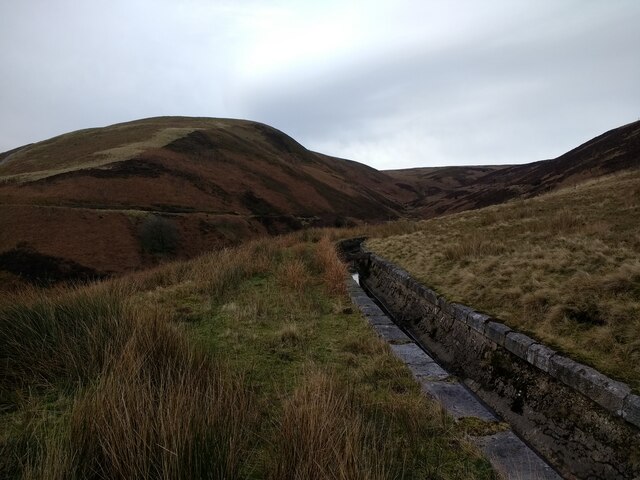
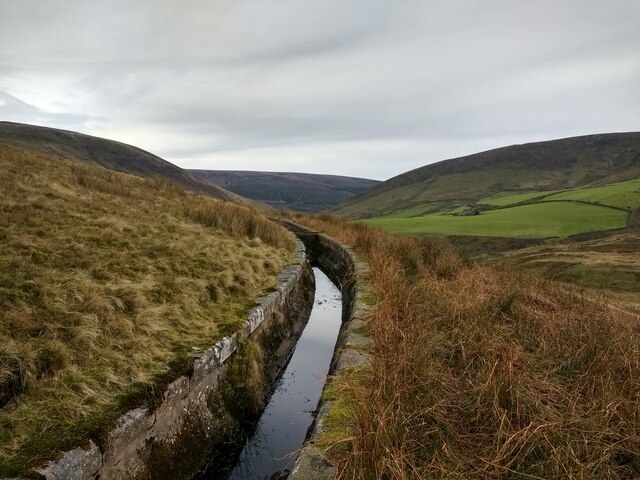
Brennand Round Hill is characterized by its distinct rounded shape, which is typical of the landscape in the Yorkshire Dales. The hill is predominantly covered in grass and heather, providing a picturesque view of the surrounding countryside. It offers stunning panoramic vistas, with views stretching across the rolling hills, valleys, and moorlands that make up this scenic part of Yorkshire.
The summit of Brennand Round Hill can be reached by several footpaths and trails that are suitable for walkers of various abilities. The most popular route starts from Malham and follows a well-defined path, allowing visitors to enjoy the natural beauty of the area as they ascend the hill. On a clear day, it is possible to see as far as the majestic Pen-y-ghent and Ingleborough, two of Yorkshire's famous Three Peaks.
Brennand Round Hill is also known for its rich biodiversity, with a variety of plant and animal species that inhabit the area. It is home to a range of birds, including peregrine falcons, curlews, and meadow pipits. The hill is also a site of interest for geologists, as it displays evidence of the region's geological history, particularly in the limestone formations that can be observed along its slopes.
Overall, Brennand Round Hill offers visitors a chance to immerse themselves in the natural beauty of the Yorkshire Dales, providing a rewarding experience for hikers, nature enthusiasts, and those seeking tranquility in a stunning rural setting.
If you have any feedback on the listing, please let us know in the comments section below.
Brennand Round Hill Images
Images are sourced within 2km of 53.999436/-2.5677267 or Grid Reference SD6256. Thanks to Geograph Open Source API. All images are credited.


Brennand Round Hill is located at Grid Ref: SD6256 (Lat: 53.999436, Lng: -2.5677267)
Division: West Riding
Administrative County: Lancashire
District: Ribble Valley
Police Authority: Lancashire
What 3 Words
///washable.spellings.typically. Near Caton, Lancashire
Nearby Locations
Related Wikis

Brennand Farm
Brennand Farm is often claimed to be the true centre of Great Britain. This is about seven kilometres north-west of Dunsop Bridge - which has the nearest...

Wolfhole Crag
Wolfhole Crag is a lonely and seldom-visited hill in the Forest of Bowland in Lancashire, England. Its seclusion is due in part to its low profile and...

Grey Stone of Trough
The Grey Stone of Trough is an historic boundary marker in Bowland Forest High, in the Trough of Bowland, Lancashire, England. A Grade II listed structure...

Trough of Bowland
The Trough of Bowland is a valley and high pass in the Forest of Bowland Area of Outstanding Natural Beauty, Lancashire, England. The pass, reaching 968...

Geography of the United Kingdom
The United Kingdom is a sovereign state located off the north-western coast of continental Europe. With a total area of approximately 248,532 square kilometres...

Ward's Stone
Ward's Stone is the highest hill in the Forest of Bowland, England. Its flat top hides two trig points nearly a kilometre apart. The western trig point...

White Hill (Forest of Bowland)
White Hill is a hill in the Forest of Bowland, north-western England. It lies between Slaidburn and High Bentham. The summit houses a tower and a trig...

National nature reserves in Lancashire
National nature reserves in Lancashire in England are established by Natural England. There are two national nature reserves in Lancashire, both of which...
Nearby Amenities
Located within 500m of 53.999436,-2.5677267Have you been to Brennand Round Hill?
Leave your review of Brennand Round Hill below (or comments, questions and feedback).