Blakehowe Hill

Hill, Mountain in Westmorland South Lakeland

England

Blakehowe Hill

The view from Scout Scar A short way from Kendal town brings these fine views over the National Park.
The view from Scout Scar Credit: David M Clark

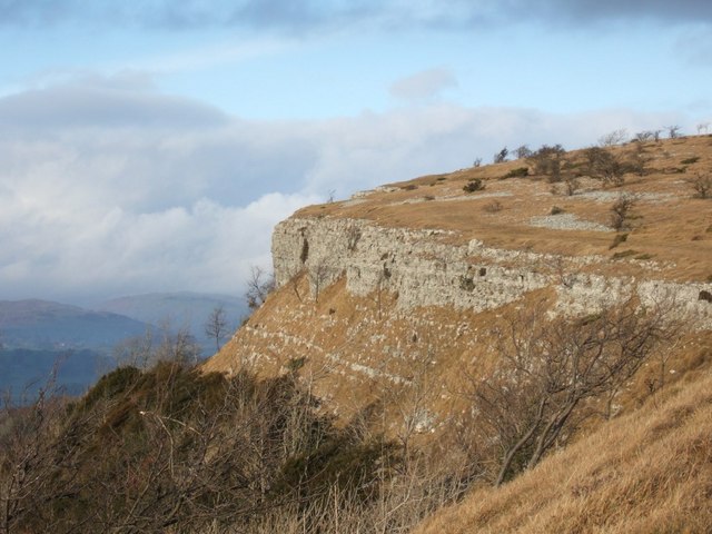
Blakehowe Hill is a prominent natural feature located in the county of Westmorland, England. Rising to an impressive height of 226 meters (741 feet), it is classified as both a hill and a mountain, offering breathtaking panoramic views of the surrounding landscape. Situated near the village of Orton, it forms part of the renowned Pennines mountain range.

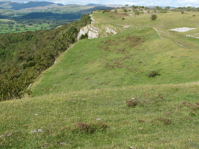
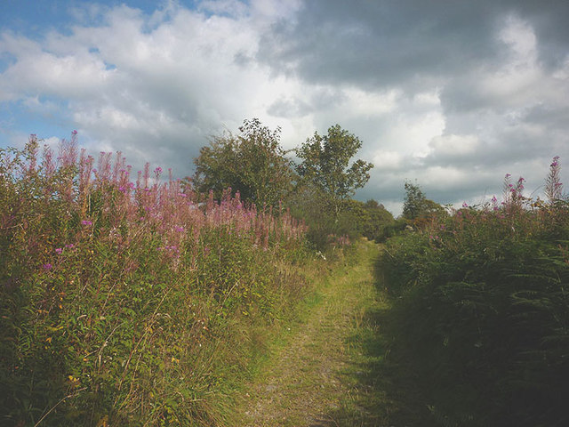
The hill is characterised by its distinctive profile, with a gentle slope on one side and a steeper incline on the other. The summit is adorned with lush greenery, including grasses, heather, and scattered trees, creating a picturesque scene throughout the year. Walking trails wind their way up the hill, making it a popular destination for hikers and nature enthusiasts.

Blakehowe Hill is renowned for its outstanding natural beauty and is a designated Area of Outstanding Natural Beauty (AONB). From the summit, visitors are treated to breathtaking vistas of the surrounding countryside, including rolling hills, valleys, and distant peaks. On clear days, it is even possible to glimpse the shimmering waters of the nearby Lake District.

Historically, the hill has held cultural significance, featuring in local folklore and traditional tales. It has also been a site of archaeological interest, with traces of ancient settlements and burial mounds found in the vicinity.

Overall, Blakehowe Hill is a remarkable natural landmark that offers a chance to immerse oneself in the stunning beauty of Westmorland's countryside. Whether it is for a leisurely walk, a challenging hike, or simply to marvel at the awe-inspiring views, this hill and mountain combination is a must-visit destination for anyone seeking a true taste of England's rural charm.

If you have any feedback on the listing, please let us know in the comments section below.

Blakehowe Hill Images

Images are sourced within 2km of 54.326855/-2.8175259 or Grid Reference SD4692. Thanks to Geograph Open Source API. All images are credited.

The view from Scout Scar A short way from Kendal town brings these fine views over the National Park.
The view from Scout Scar
A short way from Kendal town brings these fine views over the National Park.
Rivet benchmark on milestone in Underbarrow Road Ordnance Survey rivet benchmark on the top of an old milestone that once read 'Kendal 2'. The mark was levelled at 171.225m above Newlyn Datum, verified 1971. For a wider view see <a href="https://www.geograph.org.uk/photo/7456528">SD4892 : Underbarrow Road and a 'Kendal' milestone</a> and  <a href="https://www.geograph.org.uk/photo/2819112">SD4892 : Mile stone, Underbarrow Road</a>  <span class="nowrap"><a title="https://www.bench-marks.org.uk/bm190192" rel="nofollow ugc noopener" href="https://www.bench-marks.org.uk/bm190192">Link</a><img style="margin-left:2px;" alt="External link" title="External link - shift click to open in new window" src="https://s1.geograph.org.uk/img/external.png" width="10" height="10"/></span>
Rivet benchmark on milestone in Underbarrow Road
Ordnance Survey rivet benchmark on the top of an old milestone that once read 'Kendal 2'. The mark was levelled at 171.225m above Newlyn Datum, verified 1971. For a wider view see SD4892 : Underbarrow Road and a 'Kendal' milestone and SD4892 : Mile stone, Underbarrow Road LinkExternal link
Underbarrow Road and a 'Kendal' milestone Looking towards Kendal on Underbarrow Road, and on the left there is an old milestone that once read 'Kendal 2'. On top of the milestone there is an Ordnance Survey rivet benchmark <a href="https://www.geograph.org.uk/photo/7456523">SD4892 : Rivet benchmark on milestone in Underbarrow Road</a>

Milestone Society National ID: WE_KDCE02
Underbarrow Road and a 'Kendal' milestone
Looking towards Kendal on Underbarrow Road, and on the left there is an old milestone that once read 'Kendal 2'. On top of the milestone there is an Ordnance Survey rivet benchmark SD4892 : Rivet benchmark on milestone in Underbarrow Road Milestone Society National ID: WE_KDCE02
Footpath from Scout Scar to Underbarrow Road
Cottage at Fallen Yew, Underbarrow Numerous farm cats were lurking nearby!
Cottage at Fallen Yew, Underbarrow
Numerous farm cats were lurking nearby!
Giant vegetables at Fallen Yew A couple of gigantic marrows loitering by the footpath. Not something you see every day.
Giant vegetables at Fallen Yew
A couple of gigantic marrows loitering by the footpath. Not something you see every day.
Wide hedge on Blakehowe Hill, Underbarrow The footpath over the hill passes close to this extraordinarily wide hedge. The remnants of a drystone wall concealed within.
Wide hedge on Blakehowe Hill, Underbarrow
The footpath over the hill passes close to this extraordinarily wide hedge. The remnants of a drystone wall concealed within.
Tranthwaite Hall A typically sturdy Lakeland stone farmhouse which is Grade II listed <span class="nowrap"><a title="http://www.britishlistedbuildings.co.uk/en-75316-tranthwaite-hall-farmhouse-underbarrow-an" rel="nofollow ugc noopener" href="http://www.britishlistedbuildings.co.uk/en-75316-tranthwaite-hall-farmhouse-underbarrow-an">Link</a><img style="margin-left:2px;" alt="External link" title="External link - shift click to open in new window" src="https://s1.geograph.org.uk/img/external.png" width="10" height="10"/></span>
Tranthwaite Hall
A typically sturdy Lakeland stone farmhouse which is Grade II listed LinkExternal link
Tiny clapper bridge above Tranthwaite Hall Two slabs of limestone span the un-named beck which runs along the eastern flank of Bell Hill. Sadly, it would appear that Himalayan balsam is starting to take hold in this stream course. I pulled up a few specimens near the ford and bridleway above but the amount just upstream would require a determined group effort to tackle now.
Tiny clapper bridge above Tranthwaite Hall
Two slabs of limestone span the un-named beck which runs along the eastern flank of Bell Hill. Sadly, it would appear that Himalayan balsam is starting to take hold in this stream course. I pulled up a few specimens near the ford and bridleway above but the amount just upstream would require a determined group effort to tackle now.
Bridleway north of Bell Hill A very pleasant walled track lined by rosebay willowherb and lots of juicy blackberries.
Bridleway north of Bell Hill
A very pleasant walled track lined by rosebay willowherb and lots of juicy blackberries.
Lindreth Brow A white cottage in a secluded spot by the side of the bridleway which skirts south of Bell Hill.
Lindreth Brow
A white cottage in a secluded spot by the side of the bridleway which skirts south of Bell Hill.
Well near Lindreth Brow Beside the bridleway but no sign of water today.
Well near Lindreth Brow
Beside the bridleway but no sign of water today.
Bridleway south of Lindreth Brow The track emerges from woodland and enters more open pastureland.
Bridleway south of Lindreth Brow
The track emerges from woodland and enters more open pastureland.
Pastures and walls by Chapel Lane, Underbarrow Looking towards the white cottage at Mountjoy and Mountjoy Wood.
Pastures and walls by Chapel Lane, Underbarrow
Looking towards the white cottage at Mountjoy and Mountjoy Wood.
Cattle grazing by Chapel Lane, Underbarrow Beyond is the white cottage at Mountjoy.
Cattle grazing by Chapel Lane, Underbarrow
Beyond is the white cottage at Mountjoy.
The vaulted ceiling, All Saints Church, Underbarrow This is the eastern end of the church. I had to lie on the floor to get this view.
The vaulted ceiling, All Saints Church, Underbarrow
This is the eastern end of the church. I had to lie on the floor to get this view.
Wind vane and spire of All Saints Church, Underbarrow On a beautiful September afternoon.
Wind vane and spire of All Saints Church, Underbarrow
On a beautiful September afternoon.
Helicopter at The Broom A recently-arrived helicopter below <a href="https://www.geograph.org.uk/photo/2936950">SD4592 : Barn at The Broom</a> which now looks to have been converted to a dwelling since 2012.
Helicopter at The Broom
A recently-arrived helicopter below SD4592 : Barn at The Broom which now looks to have been converted to a dwelling since 2012.
Show me another place!

Blakehowe Hill is located at Grid Ref: SD4692 (Lat: 54.326855, Lng: -2.8175259)

Administrative County: Cumbria

District: South Lakeland

Police Authority: Cumbria

What 3 Words

///rehearsed.because.tadpoles. Near Kendal, Cumbria

Related Wikis

Underbarrow

Underbarrow is a small village in Cumbria, England, located 3 miles (4.8 km) west of Kendal. The village is in the Lake District National Park. It is in...

Scout Scar

Scout Scar, also called Underbarrow Scar, is a hill in the English Lake District, west of Kendal, Cumbria and above the village of Underbarrow. It reaches...

Cunswick Scar

Cunswick Scar is a limestone scar (cliff or steep rock face) in the Lake District, England. There are extensive views from the large cairn at the top...

Crook, Cumbria

Crook is a village and civil parish in the South Lakeland district of the English county of Cumbria, located on the B5284 road between Kendal and Windermere...

Bonning Gate

Bonning Gate is a hamlet in Cumbria, England. It is located 3.2 miles (5.1 km) by road to the northwest of Kendal. == See also == List of places in Cumbria...

Helsfell Hall

Helsfell Hall was a country house near Kentrigg in Cumbria. That part of the building which survives, and is now used as a barn, is a Grade II listed building...

Helsington

Helsington is a civil parish in the South Lakeland district of the English county of Cumbria. It includes the village of Brigsteer and Sizergh Castle...

Brigsteer

Brigsteer is a village in Cumbria, England. On 1 August 2016 it was included in the Lake District National Park. == Politics == In 1974, under the Local...

Nearby Amenities

Located within 500m of 54.326855,-2.8175259
Barrier: kissing_gate
Lat/Long: 54.3270274/-2.8144311
Power: pole
Lat/Long: 54.3235876/-2.8216551
Generator Method: photovoltaic
Generator Output Electricity: yes
Generator Source: solar
Generator Type: solar_photovoltaic_panel
Power: generator
Lat/Long: 54.323811/-2.8226752
Power: pole
Lat/Long: 54.3243932/-2.8226066
Power: pole
Lat/Long: 54.3299767/-2.8167471
Power: pole
Lat/Long: 54.3294854/-2.8163524
Power: pole
Lat/Long: 54.3285039/-2.8156443
Power: pole
Lat/Long: 54.3275088/-2.8149361
Power: pole
Lat/Long: 54.3268657/-2.8135368
Power: pole
Lat/Long: 54.3264788/-2.8126857
Power: pole
Lat/Long: 54.3251565/-2.8131208
Power: pole
Lat/Long: 54.3260061/-2.8133277
Power: pole
Lat/Long: 54.3269752/-2.8117556
Power: pole
Lat/Long: 54.3275076/-2.8107403
Power: pole
Lat/Long: 54.3278683/-2.8100086
Power: pole
Lat/Long: 54.3284592/-2.8110197
Power: pole
Lat/Long: 54.3247124/-2.8236946
The data included in this document is from www.openstreetmap.org. The data is made available under ODbL.

Have you been to Blakehowe Hill?

Leave your review of Blakehowe Hill below (or comments, questions and feedback).