Burton Hill

Hill, Mountain in Herefordshire

England

Burton Hill

Yazor Wood viewed from the A480 Offa's Dyke follows the hedge on the right.
Yazor Wood viewed from the A480 Credit: Philip Halling

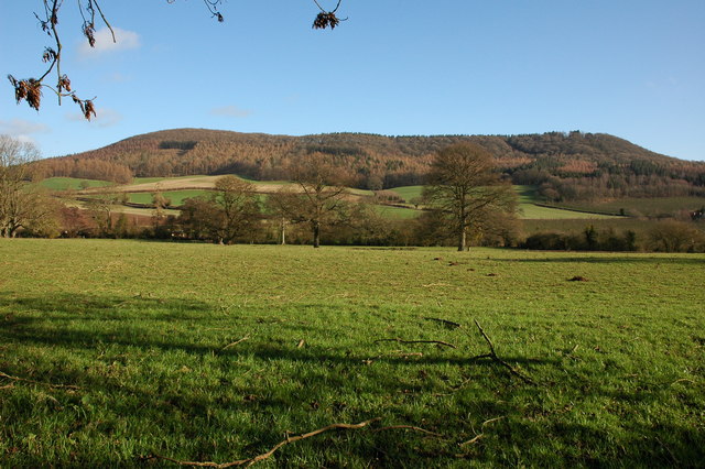
Burton Hill is a prominent hill located in the county of Herefordshire, England. Standing at an impressive height of 257 meters (843 feet), it is considered one of the highest points in the region. Situated near the village of Burton and about 5 miles southwest of the market town of Hereford, the hill offers breathtaking panoramic views of the surrounding countryside.

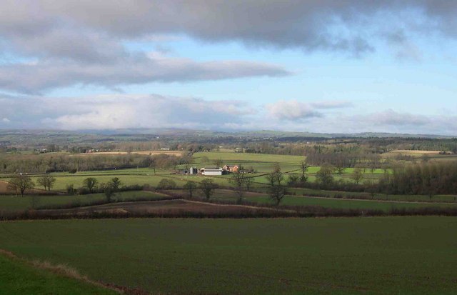
Burton Hill is part of the larger Malvern Hills Area of Outstanding Natural Beauty, known for its rolling landscapes, rich wildlife, and historical significance. The hill itself is covered in lush greenery, with grassy slopes that provide a perfect spot for picnics and leisurely walks. On a clear day, visitors can enjoy stunning vistas across the Herefordshire countryside, as well as distant views of the Black Mountains and the Brecon Beacons.

The summit of Burton Hill is marked by a trig point, a concrete pillar used in surveying, which adds to the charm of the area. It attracts many hikers and outdoor enthusiasts, who come to experience the tranquility of the surroundings and the sense of accomplishment that comes with reaching the top. The hill is also a popular destination for birdwatchers, as various species of birds can be spotted flying overhead or nesting in the trees.

Due to its location within the Area of Outstanding Natural Beauty, Burton Hill is carefully preserved and protected, ensuring that its natural beauty remains intact for future generations to enjoy. Whether you are seeking a peaceful retreat or an adventure in nature, a visit to Burton Hill is sure to provide a memorable experience.

If you have any feedback on the listing, please let us know in the comments section below.

Burton Hill Images

Images are sourced within 2km of 52.134044/-2.885783 or Grid Reference SO3948. Thanks to Geograph Open Source API. All images are credited.

Yazor Wood viewed from the A480 Offa's Dyke follows the hedge on the right.
Yazor Wood viewed from the A480
Offa's Dyke follows the hedge on the right.
Norton Canon church Norton Canon church is dedicated to St Nicholas. According to Pevsner the tower dates from the 13th century, and the nave, chancel and transepts were built in brick in the early 18th century, with the medieval church windows incorporated into the walls.  The church was featured on BBC Radio 4's programme, 'Open Country' on 21 April 2012 <span class="nowrap"><a title="http://www.bbc.co.uk/programmes/b01g63tv" rel="nofollow ugc noopener" href="http://www.bbc.co.uk/programmes/b01g63tv">Link</a><img style="margin-left:2px;" alt="External link" title="External link - shift click to open in new window" src="https://s1.geograph.org.uk/img/external.png" width="10" height="10"/></span> In particular the programme features the restoration of the church bells
Norton Canon church
Norton Canon church is dedicated to St Nicholas. According to Pevsner the tower dates from the 13th century, and the nave, chancel and transepts were built in brick in the early 18th century, with the medieval church windows incorporated into the walls. The church was featured on BBC Radio 4's programme, 'Open Country' on 21 April 2012 LinkExternal link In particular the programme features the restoration of the church bells
View to the east from Norton Canon The view to the east from Norton Canon is dominated by Burton Hill and Yazor Wood.
View to the east from Norton Canon
The view to the east from Norton Canon is dominated by Burton Hill and Yazor Wood.
Houses at Moorhampton
View west from Upperton
View from Norton Canon churchyard View to the south-west from Norton Canon churchyard, the Black Mountains can be seen on the horizon.
View from Norton Canon churchyard
View to the south-west from Norton Canon churchyard, the Black Mountains can be seen on the horizon.
Trig point on Burton Hill The trig point on Burton Hill is not positioned at the highest point as can be seen from this picture. The trig point is 287m above sea level, however the land to the south-west rises to just over 290m.
Trig point on Burton Hill
The trig point on Burton Hill is not positioned at the highest point as can be seen from this picture. The trig point is 287m above sea level, however the land to the south-west rises to just over 290m.
Footpath through the woodland on Burton Hill This footpath descends to a track which contours the northern slopes of the hill.
Footpath through the woodland on Burton Hill
This footpath descends to a track which contours the northern slopes of the hill.
Devereux Wootton Devereux Wootton is a farm on the B4230. Here it is viewed from the south-east. The high ground on the horizon directly above the farmhouse is Black Mixen which rises to just over 2000ft above sea level and is easily identified by the transmitter on its summit.
Devereux Wootton
Devereux Wootton is a farm on the B4230. Here it is viewed from the south-east. The high ground on the horizon directly above the farmhouse is Black Mixen which rises to just over 2000ft above sea level and is easily identified by the transmitter on its summit.
The B4230 near Shoals Bank Shoals Bank is the house which can be seen above the road on the right.
The B4230 near Shoals Bank
Shoals Bank is the house which can be seen above the road on the right.
Yazor Wood and Claypits Viewed from the A480.
Yazor Wood and Claypits
Viewed from the A480.
Cottage at Upperton
Cottage at Upperton
Apple orchard, Bunn's Lane Farm
Milepost near Devereux Wootton Milepost on the B4230.
Milepost near Devereux Wootton
Milepost on the B4230.
Norton Canon - Old Vicarage Taken from the footpath leading from the road to St Nicholas' Church.
Norton Canon - Old Vicarage
Taken from the footpath leading from the road to St Nicholas' Church.
Hyatt Sarnesfield From Shoals Bank
Hyatt Sarnesfield
From Shoals Bank
Sheep on Shoals Bank From the B4230
Sheep on Shoals Bank
From the B4230
Show me another place!

Burton Hill is located at Grid Ref: SO3948 (Lat: 52.134044, Lng: -2.885783)

Unitary Authority: County of Herefordshire

Police Authority: West Mercia

What 3 Words

///recent.annotated.ticket. Near Yazor, Herefordshire

Related Wikis

Norton Canon

Norton Canon is a village and civil parish in Herefordshire, England, near the A480 road and the B4230 road. The population at the 2011 Census was 242...

Moorhampton railway station

Moorhampton railway station was a station in the hamlet of Moorhampton, to the east of Norton Canon, Herefordshire, England. The station was opened for...

Yazor

Yazor is a small village and civil parish in Herefordshire, England. The village is on the A480 road, approximately 8 miles (13 km) north-west of the city...

St Mary the Virgin's Church, Yazor

St Mary the Virgin's Church is a redundant Anglican church in the village of Yazor, Herefordshire, England. It is recorded in the National Heritage List...

Weobley High School

Weobley High School is a mixed secondary school located in Weobley in the English county of Herefordshire.It is a community school administered by Herefordshire...

Weobley Castle, Herefordshire

Weobley Castle was a ringwork and bailey castle in the English county of Herefordshire (grid reference SO40365135). The castle belonged to the De Lacy...

Sarnesfield

Sarnesfield (National Grid ref. SO374508) is a civil parish and village in Herefordshire, eleven miles north-west of Hereford. == Descent of the manor... ==

Foxley, Herefordshire

Foxley is a rural estate, and the former Foxley Manor country seat, in Herefordshire, England. The Manor is associated with the judicial, political, artistic...

Nearby Amenities

Located within 500m of 52.134044,-2.885783
Burton Hill
Ele: 294
Natural: peak
Lat/Long: 52.1340803/-2.8860065
The data included in this document is from www.openstreetmap.org. The data is made available under ODbL.

Have you been to Burton Hill?

Leave your review of Burton Hill below (or comments, questions and feedback).