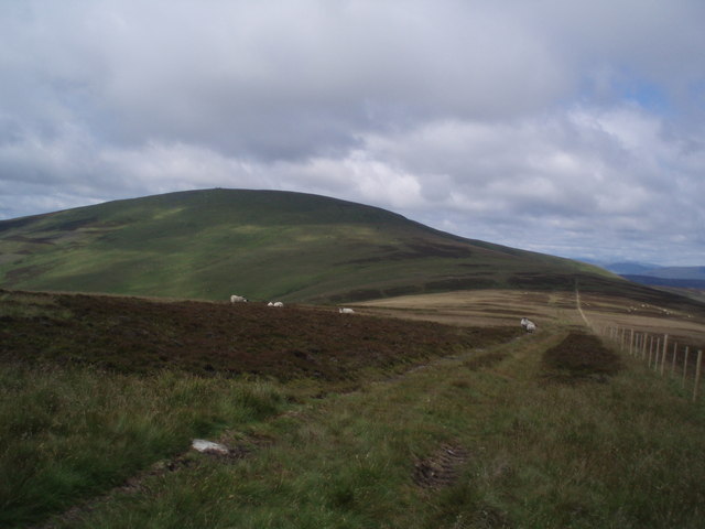
Craigiemeg Hill

Hill, Mountain in Angus

Scotland

Craigiemeg Hill

Gamekeeper's House at the head of Glen Prosen
Gamekeeper's House at the head of Glen Prosen Credit: Oliver Dixon

Craigiemeg Hill is a prominent geographical feature located in the county of Angus, Scotland. Rising to an elevation of 456 meters (1,496 feet), it is classified as a hill rather than a mountain. Situated near the village of Glamis, Craigiemeg Hill is a popular destination for outdoor enthusiasts, hikers, and nature lovers.

The hill is characterized by its gently sloping sides, covered with picturesque heather and grasses, which create a vibrant landscape during the warmer months. It offers breathtaking panoramic views of the surrounding countryside, including the nearby Sidlaws and Grampian Mountains. On clear days, it is even possible to catch glimpses of the North Sea shimmering in the distance.

Craigiemeg Hill is home to a diverse array of flora and fauna, adding to its natural beauty. Visitors can spot various species of birds, including buzzards, kestrels, and pheasants, soaring above the hill. The surrounding woodlands are inhabited by deer, rabbits, and other small mammals, creating opportunities for wildlife observation and photography.

The hill is easily accessible by foot, with several well-maintained trails leading to the summit. Its moderate incline makes it suitable for hikers of all skill levels, including families with children. At the top, there is a small cairn marking the highest point, providing a sense of achievement for those who reach it.

Overall, Craigiemeg Hill offers an enjoyable and rewarding outdoor experience, combining stunning scenery, diverse wildlife, and a peaceful atmosphere. Whether for a challenging hike or a leisurely stroll, this hill is a must-visit destination for anyone exploring the Angus region of Scotland.

If you have any feedback on the listing, please let us know in the comments section below.

Craigiemeg Hill Images

Images are sourced within 2km of 56.802506/-3.1388468 or Grid Reference NO3068. Thanks to Geograph Open Source API. All images are credited.

Gamekeeper's House at the head of Glen Prosen
Cramie Farm and Prosen Water
Boundary of the Cairngorms National Park, Glen Prosen The osprey is the distinctive emblem of the Cairngorms National Park, at over 4500 square kilometres the largest National Park in the United Kingdom.
Boundary of the Cairngorms National Park, Glen Prosen
The osprey is the distinctive emblem of the Cairngorms National Park, at over 4500 square kilometres the largest National Park in the United Kingdom.
Roadhead, Glen Prosen A small car park at the head of the public road in Glen Prosen. Ahead runs a forestry road, to the left an estate road goes up to the very head of the Glen.
Roadhead, Glen Prosen
A small car park at the head of the public road in Glen Prosen. Ahead runs a forestry road, to the left an estate road goes up to the very head of the Glen.
The Glenclova Forest track reaches the road in Glen Prosen Construction work was taking place at Runtaleave, and so there were more than the usual number of vehicles around.
The Glenclova Forest track reaches the road in Glen Prosen
Construction work was taking place at Runtaleave, and so there were more than the usual number of vehicles around.
Looking down Glen Prosen
Prosen Water Above Cramie on a dreich day!
Prosen Water
Above Cramie on a dreich day!
Cramie In Glen Prosen.
Cramie
In Glen Prosen.
End of the road The end of the public road up Glen Prosen.
End of the road
The end of the public road up Glen Prosen.
Bridge over the Prosen Water Bridge carrying the road over the Prosen Water near its end at Glenprosen Lodge.
Bridge over the Prosen Water
Bridge carrying the road over the Prosen Water near its end at Glenprosen Lodge.
Glen Prosen at Cormuir The most prominent peak on the skyline is Driesh <a href="https://www.geograph.org.uk/gridref/NO2773">NO2773</a>, still with patches of snow even on south-facing slopes.
Glen Prosen at Cormuir
The most prominent peak on the skyline is Driesh NO2773, still with patches of snow even on south-facing slopes.
Glen Prosen - the path to Glen Markie and Glen Isla One of a chain of signposted paths linking the Glens of Angus.
Glen Prosen - the path to Glen Markie and Glen Isla
One of a chain of signposted paths linking the Glens of Angus.
In Glen Prosen Only a short distance below the end of the public road.
In Glen Prosen
Only a short distance below the end of the public road.
Prosen Water Near Cormuir.
Typical 'glen weather'.
Prosen Water
Near Cormuir. Typical 'glen weather'.
Prosen Water Near Craigiemeg.
Prosen Water
Near Craigiemeg.
Craigiemeg from Glen Prosen The isolated hillside cottage of Craigiemeg, viewed from the road in Glen Prosen.
Craigiemeg from Glen Prosen
The isolated hillside cottage of Craigiemeg, viewed from the road in Glen Prosen.
Sheep near Cormuir Sheep scattered around a field of buttercups near Cormuir in Glen Prosen.
Sheep near Cormuir
Sheep scattered around a field of buttercups near Cormuir in Glen Prosen.
Prosen Water Near Glen Prosen.  Looking downstream. This part of the glen is partly cultivated with an area of moorland on the southern side.
Prosen Water
Near Glen Prosen. Looking downstream. This part of the glen is partly cultivated with an area of moorland on the southern side.
Show me another place!

Craigiemeg Hill is located at Grid Ref: NO3068 (Lat: 56.802506, Lng: -3.1388468)

Unitary Authority: Angus

Police Authority: Tayside

What 3 Words

///thighs.stones.basin. Near Kirriemuir, Angus

Nearby Locations

Craigiemeg Hill

Related Wikis

Clova, Angus

Clova is a village in Glen Clova, Angus, Scotland. It lies on the River South Esk, some 12 miles (19 km) north of Kirriemuir. During the 1745 Jacobite...

Driesh

Driesh (Gaelic: Dris) is a mountain located in the Grampians of Scotland. Apart from Mount Keen (939 m/3,080 ft), it is the most easterly of the Munro...

Cat Law

Cat Law (671 m) is a hill in the southern Mounth of Scotland, north of Kirriemuir in Angus. A rounded peak, it lies above Strathmore in the south and offers...

Mayar (mountain)

Mayar is a mountain in the Grampians, in Angus, Scotland. It is usually climbed together with its near neighbour, Driesh. At an elevation of 928 m, it...

Nearby Amenities

Located within 500m of 56.802506,-3.1388468
Craigiemeg Hill
Ele: 454
Natural: peak
Lat/Long: 56.8016319/-3.1381379
The data included in this document is from www.openstreetmap.org. The data is made available under ODbL.

Have you been to Craigiemeg Hill?

Leave your review of Craigiemeg Hill below (or comments, questions and feedback).