Cairn Inks

Hill, Mountain in Angus

Scotland

Cairn Inks

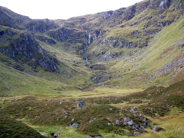
Atton below Cairn Inks Carlowie is the corrie with Bassies the hill on the right.
Atton below Cairn Inks Credit: Russel Wills

Cairn Inks is a picturesque hill located in the Angus region of Scotland. It is part of the Angus Glens and stands at an elevation of approximately 715 meters (2,346 feet) above sea level. The hill is renowned for its stunning panoramic views and is a popular destination for hikers, nature enthusiasts, and photographers.

The name "Cairn Inks" is derived from the Gaelic word "cairn," meaning a pile of stones, and "inks," which refers to the color black. This refers to the dark-colored rocks found on the hill, which are often used to create cairns, small stone structures that mark the trails and summits.

The ascent to Cairn Inks is moderate to challenging, with a well-marked path leading to the summit. The hill offers various routes for hikers, allowing them to explore different parts of the Angus Glens and enjoy the breathtaking landscapes of the surrounding countryside.

The summit of Cairn Inks provides an excellent vantage point, offering panoramic views of the neighboring hills, glens, and the picturesque Glen Isla. On clear days, it is possible to see as far as the Cairngorms National Park and the Grampian Mountains.

The area around Cairn Inks is home to diverse flora and fauna, including heather, mosses, and various species of birds and mammals. The hill is also known for its rich historical and cultural heritage, with ancient ruins and standing stones scattered throughout the landscape.

Cairn Inks is a must-visit destination for those seeking to immerse themselves in the natural beauty and history of the Angus region. Its stunning views, challenging trails, and unique geological features make it a truly remarkable hill to explore.

If you have any feedback on the listing, please let us know in the comments section below.

Cairn Inks Images

Images are sourced within 2km of 56.839105/-3.140122 or Grid Reference NO3072. Thanks to Geograph Open Source API. All images are credited.

Atton below Cairn Inks Carlowie is the corrie with Bassies the hill on the right.
Atton below Cairn Inks
Carlowie is the corrie with Bassies the hill on the right.
Landslip or slumping After much heavy rain the hillside has slipped down taking out the fence beside the road. Any more and the road to Braedownie and Acharn will be blocked.
Landslip or slumping
After much heavy rain the hillside has slipped down taking out the fence beside the road. Any more and the road to Braedownie and Acharn will be blocked.
The road up Glen Clova to Acharn With rainbow.
The road up Glen Clova to Acharn
With rainbow.
The Mains Glen Clova Ben Reid on the left.
The Mains Glen Clova
Ben Reid on the left.
Site of Clova Castle The only extant remains is part of a circular square tower.
Site of Clova Castle
The only extant remains is part of a circular square tower.
The River South Esk from bridge southwest of Clova
Burn of Bonhard Descending from Corrie of Bonhard.
Burn of Bonhard
Descending from Corrie of Bonhard.
Burning debris after clear felling Filling Glen Clova with wood smoke!  A legal arsonist?
Burning debris after clear felling
Filling Glen Clova with wood smoke! A legal arsonist?
Pasture in Glen Clova  Looking towards Cairn of Barns.
Pasture in Glen Clova
Looking towards Cairn of Barns.
Burn of Bonhard Burn descending the east side of Glen Clova.
Burn of Bonhard
Burn descending the east side of Glen Clova.
Atton, Glen Clova The cottage on the far side of the Glen is dwarfed by the mountainside beyond. The corrie to the right is Corlowie <a href="https://www.geograph.org.uk/gridref/NO3073">NO3073</a>. Snow clings even to south-facing slopes.
Atton, Glen Clova
The cottage on the far side of the Glen is dwarfed by the mountainside beyond. The corrie to the right is Corlowie NO3073. Snow clings even to south-facing slopes.
Glen Clova Atton cottage is set in the small clump of trees on the far side of the Glen. The corrie above is Corlowie <a href="https://www.geograph.org.uk/gridref/NO3073">NO3073</a>.
Glen Clova
Atton cottage is set in the small clump of trees on the far side of the Glen. The corrie above is Corlowie NO3073.
Road up Glen Clova A dead tree stands beside the road. Snow lingers on the mountains even on south-facing slopes.
Road up Glen Clova
A dead tree stands beside the road. Snow lingers on the mountains even on south-facing slopes.
Road up Glen Clova
Road up Glen Clova
Glen Clova A peaceful reach of the South Esk in late winter, taken from the bridge near Clova Hotel. The mountain at the head of the glen is unusual in that the summit (866 metres) in <a href="https://www.geograph.org.uk/gridref/NO2677">NO2677</a> is unnamed on the 1:50,000 map, but the crag on the left of the corrie is Craig Mellon and on the right is Cairn Broadlands (852 metres). Compare <a href="https://www.geograph.org.uk/photo/1744002">NO3272 : Glen Clova</a>, taken 30 years later.
Glen Clova
A peaceful reach of the South Esk in late winter, taken from the bridge near Clova Hotel. The mountain at the head of the glen is unusual in that the summit (866 metres) in NO2677 is unnamed on the 1:50,000 map, but the crag on the left of the corrie is Craig Mellon and on the right is Cairn Broadlands (852 metres). Compare NO3272 : Glen Clova, taken 30 years later.
Glen Clova looking north west
View across the Esk While the Autumn sunshine warmed the grazing cattle, the soft Scottish rain caressed the mighty pine trees.
View across the Esk
While the Autumn sunshine warmed the grazing cattle, the soft Scottish rain caressed the mighty pine trees.
Glen Clova. Chestnut paling fence to keep the snow that refuses to fall off the road. View up the glen to Hill of Strone.  A textbook glacial glen with a flat floor and steep sides.
Glen Clova.
Chestnut paling fence to keep the snow that refuses to fall off the road. View up the glen to Hill of Strone. A textbook glacial glen with a flat floor and steep sides.
Show me another place!

Cairn Inks is located at Grid Ref: NO3072 (Lat: 56.839105, Lng: -3.140122)

Unitary Authority: Angus

Police Authority: Tayside

What 3 Words

///albatross.scornful.ranking. Near Kirriemuir, Angus

Nearby Locations

Cairn Inks

Related Wikis

Clova, Angus

Clova is a village in Glen Clova, Angus, Scotland. It lies on the River South Esk, some 12 miles (19 km) north of Kirriemuir. During the 1745 Jacobite...

Driesh

Driesh (Gaelic: Dris) is a mountain located in the Grampians of Scotland. Apart from Mount Keen (939 m/3,080 ft), it is the most easterly of the Munro...

Glen Doll

Glen Doll, also sometimes spelt Glendoll, lies within the Cairngorms National Park, Scotland, at the top of Glen Clova, in an area of steep hills, corries...

Corrie Fee

Corrie Fee is a glacier-carved corrie situated at the head of Glen Clova in the Angus Glens of Scotland. It forms part of Corrie Fee National Nature Reserve...

Nearby Amenities

Located within 500m of 56.839105,-3.140122
Cairn Inks
Ele: 756
Natural: peak
Lat/Long: 56.8378058/-3.136005
The data included in this document is from www.openstreetmap.org. The data is made available under ODbL.

Have you been to Cairn Inks?

Leave your review of Cairn Inks below (or comments, questions and feedback).