Dubh Breac Hill

Hill, Mountain in Aberdeenshire

Scotland

Dubh Breac Hill

Duffdefiance covered in snow & Water of Nochty It had been an icy walk in from Auchernach crampons would have been more suited to the conditions.
The ruin is crumbling and offers little in the way of shelter, the wall leading away from the ruin was almost covered in snow.
A SMHC day out to The Ladder Hills Dun Muir & Carn Mor
Duffdefiance covered in snow & Water of Nochty Credit: Liz Gray

Dubh Breac Hill is a prominent hill located in Aberdeenshire, Scotland. It is situated in the eastern part of the county, near the town of Alford. The hill is part of the Grampian Mountains, which stretch across the region and are known for their rugged beauty.

Standing at an elevation of approximately 595 meters (1,952 feet), Dubh Breac Hill offers stunning panoramic views of the surrounding countryside. Its distinctive shape and steep slopes make it a popular destination for hikers and outdoor enthusiasts. The hill is covered in heather and grass, giving it a picturesque appearance, especially during the summer months when the flowers are in bloom.

The walking trail leading to the summit of Dubh Breac Hill is well-marked and relatively easy to follow, although the terrain can be challenging in some sections. As visitors ascend the hill, they are treated to breathtaking vistas of Aberdeenshire, with its rolling hills, expansive farmland, and scattered woodland.

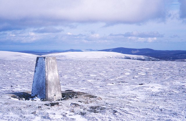
At the summit, there is a trig point, which serves as a marker for surveying purposes. From here, on a clear day, one can see as far as the Cairngorms National Park, approximately 40 miles to the west. The summit also provides an excellent vantage point for birdwatching, as various species can be spotted soaring through the skies or perched on nearby rocks.

Dubh Breac Hill is a natural treasure in Aberdeenshire, offering visitors the chance to immerse themselves in the region's stunning landscapes and experience the tranquility of the Scottish countryside.

If you have any feedback on the listing, please let us know in the comments section below.

Dubh Breac Hill Images

Images are sourced within 2km of 57.222684/-3.1673 or Grid Reference NJ2915. Thanks to Geograph Open Source API. All images are credited.

Duffdefiance covered in snow & Water of Nochty It had been an icy walk in from Auchernach crampons would have been more suited to the conditions.
The ruin is crumbling and offers little in the way of shelter, the wall leading away from the ruin was almost covered in snow.
A SMHC day out to The Ladder Hills Dun Muir & Carn Mor
Duffdefiance covered in snow & Water of Nochty
It had been an icy walk in from Auchernach crampons would have been more suited to the conditions. The ruin is crumbling and offers little in the way of shelter, the wall leading away from the ruin was almost covered in snow. A SMHC day out to The Ladder Hills Dun Muir & Carn Mor
Ruins of Rigorach Ruined croft beside the Water of Nochty.
Ruins of Rigorach
Ruined croft beside the Water of Nochty.
Ruins of Duffdefiance Ruined croft beside the Water of Nochty.
Ruins of Duffdefiance
Ruined croft beside the Water of Nochty.
Moorland near Duffdefiance Looking from the Ladder Path across the Water of Nochty towards Hill of Righorach and Dubh Breac Hill.
Moorland near Duffdefiance
Looking from the Ladder Path across the Water of Nochty towards Hill of Righorach and Dubh Breac Hill.
Track alongside Water of Nochty A landrover track which crosses back & forth over the river at several fords.
Track alongside Water of Nochty
A landrover track which crosses back & forth over the river at several fords.
An old grouse butt on Dubh Breac Hill In a line of derelict butts northeast of the summit.
An old grouse butt on Dubh Breac Hill
In a line of derelict butts northeast of the summit.
Aldachuie (Lost Gallery) A former farm in Glen Nochty, now the gallery of talented artist Peter Goodfellow - <span class="nowrap"><a title="http://www.lostgallery.co.uk/" rel="nofollow ugc noopener" href="http://www.lostgallery.co.uk/">Link</a><img style="margin-left:2px;" alt="External link" title="External link - shift click to open in new window" src="https://s1.geograph.org.uk/img/external.png" width="10" height="10"/></span>.

The Gaelic name of the farm derives from Allt a' Chithe ('burn of mist').
Aldachuie (Lost Gallery)
A former farm in Glen Nochty, now the gallery of talented artist Peter Goodfellow - LinkExternal link. The Gaelic name of the farm derives from Allt a' Chithe ('burn of mist').
'In Ferrous Defense of the Lost' A sculpture by the American artist Matt Toole, dating from 1999, by the Lost Gallery in Glen Nochty.
'In Ferrous Defense of the Lost'
A sculpture by the American artist Matt Toole, dating from 1999, by the Lost Gallery in Glen Nochty.
Righorach, Glen Nochty The site of a former settlement, glimpsed through a gap in the forestry plantations.
Righorach, Glen Nochty
The site of a former settlement, glimpsed through a gap in the forestry plantations.
Marsh at source of Quillichan Burn This is an unusual feature. The Quillichan Burn flows NE from here to Glen Nochty and the Shannach Burn flows SE from here to Glen Ernan. I presume the steep sided valley of the Quillichan Burn is a glacial meltwater channel and there are extensive fluvio-glacial deposits where this channel joins Glen Nochty (need to do some more research). As we arrived we disturbed a lapwing. A favourite place for the grouse shooting parties.
Marsh at source of Quillichan Burn
This is an unusual feature. The Quillichan Burn flows NE from here to Glen Nochty and the Shannach Burn flows SE from here to Glen Ernan. I presume the steep sided valley of the Quillichan Burn is a glacial meltwater channel and there are extensive fluvio-glacial deposits where this channel joins Glen Nochty (need to do some more research). As we arrived we disturbed a lapwing. A favourite place for the grouse shooting parties.
On the track to Glen Nochty
Summer house on Edinglassie estate Winter track from Ernan to grouse moors.
Summer house on Edinglassie estate
Winter track from Ernan to grouse moors.
Bridge crossing Allt Slochd Chaimbeil A tributary of the Water of Nochty in The Ladder Hills
Bridge crossing Allt Slochd Chaimbeil
A tributary of the Water of Nochty in The Ladder Hills
Tin Roof on shelter The corner of a corrugated tin roof with Carn Mor in background.  Track leading to Long Moss
Tin Roof on shelter
The corner of a corrugated tin roof with Carn Mor in background. Track leading to Long Moss
Fence junction below Shannach Moss near Glen Buchat, Strathdon
Track buried in snow drifts east of The Socach in The Ladder Hills, Strathdon
East flank of The Socach in The Ladder Hills, Strathdon
Fencline east of Shannach Burn in The Ladder Hills, Strathdon
Show me another place!

Dubh Breac Hill is located at Grid Ref: NJ2915 (Lat: 57.222684, Lng: -3.1673)

Unitary Authority: Aberdeenshire

Police Authority: North East

What 3 Words

///domestic.shredder.tenses. Near Ballater, Aberdeenshire

Nearby Locations

Dubh Breac Hill

Related Wikis

Ladder Hills

The Ladder Hills (Scottish Gaelic: Monadh an Fhàraidh) are a range of hills in northeast Scotland which straddle the border between Aberdeenshire and Moray...

Càrn Mòr (Ladder Hills)

Càrn Mòr (804 m) is the highest mountain of the Ladder Hills on the border of Aberdeenshire and Moray, Scotland. It is located northeast of the Cairngorm...

Lost, Aberdeenshire

Lost (Lòsda in Scottish Gaelic; population: less than 24; grid reference NJ349132 or on 1869 map) is a hamlet in Aberdeenshire, Scotland. It lies 40 miles...

Badenyon Castle

Badenyon Castle was a castle, dating from the 13th century around 7.5 miles (12.1 km) west of Kildrummy, north of Coulins Burn, in Aberdeenshire, Scotland...

Badenyon

Badenyon (from Scottish Gaelic: Bad an Eòin - Knoll of the Birds) is a former clachan, or village, in Aberdeenshire, Scotland. The last farming inhabitant...

Doune of Invernochty

The Doune of Invernochty is a 12th-century castle in the Cairngorms National Park in Scotland, of which only earthworks survive. The Royal Commission on...

Strathdon

Strathdon (; Gaelic: Srath Dheathain) is an area in Aberdeenshire, Scotland. It is situated in the strath of the River Don, 45 miles west of Aberdeen in...

Scalan

The Scalan was once a seminary and was one of the few places in Scotland where the Roman Catholic faith was kept alive during the troubled times of the...

Nearby Amenities

Located within 500m of 57.222684,-3.1673
Dubh Breac Hill
Place: locality
Lat/Long: 57.2229545/-3.164922
The data included in this document is from www.openstreetmap.org. The data is made available under ODbL.

Have you been to Dubh Breac Hill?

Leave your review of Dubh Breac Hill below (or comments, questions and feedback).