Tom a' Gharraidh

Hill, Mountain in Aberdeenshire

Scotland

Tom a' Gharraidh

Looking back... ...at the access gate to Corgarff Castle.  The place was deserted in August 2021 when the site was closed due to Covid-19.
Looking back... Credit: Bill Harrison

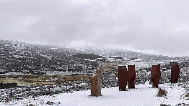
Tom a' Gharraidh is a prominent hill located in Aberdeenshire, Scotland. Standing at an impressive height of 1,204 feet (367 meters), it is a popular destination for outdoor enthusiasts and hikers. The hill is situated in a picturesque area, surrounded by stunning natural beauty and breathtaking views of the Scottish Highlands.

Tom a' Gharraidh is part of the wider Cairngorms National Park, which is known for its diverse ecosystems and rich wildlife. The hill itself boasts a variety of flora and fauna, including heather, mosses, and a range of bird species. Hikers can expect to encounter a peaceful and tranquil environment as they explore its slopes.

The hill offers a range of hiking trails suitable for all levels of experience, although some sections may be more challenging than others. The paths are well-maintained, ensuring a safe and enjoyable experience for visitors. At the summit, hikers are rewarded with sweeping panoramic views of the surrounding area, including nearby mountains and valleys.

Tom a' Gharraidh is easily accessible from nearby towns and villages, with ample parking available for visitors. It is a popular destination for day trips and offers a great opportunity for nature lovers to immerse themselves in the beauty of the Scottish countryside. Whether you are an avid hiker or simply seeking a peaceful retreat, Tom a' Gharraidh is a must-visit destination in Aberdeenshire.

If you have any feedback on the listing, please let us know in the comments section below.

Tom a' Gharraidh Images

Images are sourced within 2km of 57.158595/-3.2273937 or Grid Reference NJ2508. Thanks to Geograph Open Source API. All images are credited.

Looking back... ...at the access gate to Corgarff Castle.  The place was deserted in August 2021 when the site was closed due to Covid-19.
Looking back...
...at the access gate to Corgarff Castle. The place was deserted in August 2021 when the site was closed due to Covid-19.
Trees in the landscape Deciduous trees are getting sparse at the edge of highland moors.
Trees in the landscape
Deciduous trees are getting sparse at the edge of highland moors.
Corgarff Castle The remote castle was built in the 15th Century and the curtain wall was added in the aftermath of the '45 uprising.  Scheduled monument SM90080: <span class="nowrap"><a title="http://portal.historicenvironment.scot/designation/SM90080" rel="nofollow ugc noopener" href="http://portal.historicenvironment.scot/designation/SM90080">Link</a><img style="margin-left:2px;" alt="External link" title="External link - shift click to open in new window" src="https://s1.geograph.org.uk/img/external.png" width="10" height="10"/></span> .
Corgarff Castle
The remote castle was built in the 15th Century and the curtain wall was added in the aftermath of the '45 uprising. Scheduled monument SM90080: LinkExternal link .
Highland vista The view north from Corgarff Castle, with the valley of the River Don in the foreground and in the far distance the ski tow up to the 779-metre summit of Meikle Corr Riabhach: <span class="nowrap"><a title="https://en.wikipedia.org/wiki/Lecht_Ski_Centre" rel="nofollow ugc noopener" href="https://en.wikipedia.org/wiki/Lecht_Ski_Centre">Link</a><img style="margin-left:2px;" alt="External link" title="External link - shift click to open in new window" src="https://s1.geograph.org.uk/img/external.png" width="10" height="10"/></span> .
Highland vista
The view north from Corgarff Castle, with the valley of the River Don in the foreground and in the far distance the ski tow up to the 779-metre summit of Meikle Corr Riabhach: LinkExternal link .
Side view... ...of Corgarff Castle, with Cock Burn valley in the background.
Side view...
...of Corgarff Castle, with Cock Burn valley in the background.
Corgarff Castle in the landscape... ...with Cockbridge Farm just visible in the background.
Corgarff Castle in the landscape...
...with Cockbridge Farm just visible in the background.
View towards Allargue Bridge... ...carrying the A939 over the River Don: see Canmore record 121284: <span class="nowrap"><a title="https://canmore.org.uk/site/121284/river-don-allargue-bridge" rel="nofollow ugc noopener" href="https://canmore.org.uk/site/121284/river-don-allargue-bridge">Link</a><img style="margin-left:2px;" alt="External link" title="External link - shift click to open in new window" src="https://s1.geograph.org.uk/img/external.png" width="10" height="10"/></span> .  The A939 is about 96 km long and links Ballater and Nairn and is renowned as the 'first road to be closed by snow'(  <span class="nowrap"><a title="https://www.sabre-roads.org.uk/wiki/index.php?title=A939" rel="nofollow ugc noopener" href="https://www.sabre-roads.org.uk/wiki/index.php?title=A939">Link</a><img style="margin-left:2px;" alt="External link" title="External link - shift click to open in new window" src="https://s1.geograph.org.uk/img/external.png" width="10" height="10"/></span> ) but not on a beautiful August day.
View towards Allargue Bridge...
...carrying the A939 over the River Don: see Canmore record 121284: LinkExternal link . The A939 is about 96 km long and links Ballater and Nairn and is renowned as the 'first road to be closed by snow'( LinkExternal link ) but not on a beautiful August day.
Sheep by the Don Upland sheep grazing beside the River Don just north of Corgarff Castle.
Sheep by the Don
Upland sheep grazing beside the River Don just north of Corgarff Castle.
Yet another view of Corgarff Castle... ...from the Hill of Allargue parking area about 1 km to the north.
Yet another view of Corgarff Castle...
...from the Hill of Allargue parking area about 1 km to the north.
Looking down the River Don valley In the far distance, the A959 road can be seen climbing towards Glen Fenzie pass.
Looking down the River Don valley
In the far distance, the A959 road can be seen climbing towards Glen Fenzie pass.
Viewing area beside the A939 There are fine views south towards Cordarff Castle and east and west along the River Don valley.  The stone has several 'viewing pipes' to look through.
Viewing area beside the A939
There are fine views south towards Cordarff Castle and east and west along the River Don valley. The stone has several 'viewing pipes' to look through.
Corgarff Castle Built around 1530, and now in the care of Historic Environment Scotland.
Photo taken from the side of the A939 road.
Corgarff Castle
Built around 1530, and now in the care of Historic Environment Scotland. Photo taken from the side of the A939 road.
The Watchers Modern standing stone and hooded seats - for detail, see <a href="https://www.geograph.org.uk/photo/5960303">NJ2509 : Standing Stone</a> and <a href="https://www.geograph.org.uk/photo/5960306">NJ2509 : Hooded Seats</a>.
The Watchers
Modern standing stone and hooded seats - for detail, see NJ2509 : Standing Stone and NJ2509 : Hooded Seats.
View from layby below Hill of Allargue
Take a moment to behold - The watchers Four folded steel cowls forming hooded shelters over individual larch seats, designed by architect John Kennedy and installed in 2015, alongside an older standing stone
Take a moment to behold - The watchers
Four folded steel cowls forming hooded shelters over individual larch seats, designed by architect John Kennedy and installed in 2015, alongside an older standing stone
Parking and picnic site, Corgarff
A939 near Cock Bridge
Cock Bridge over the River Don Old bridge beside the current bridge.
Cock Bridge over the River Don
Old bridge beside the current bridge.
Show me another place!

Tom a' Gharraidh is located at Grid Ref: NJ2508 (Lat: 57.158595, Lng: -3.2273937)

Unitary Authority: Aberdeenshire

Police Authority: North East

What 3 Words

///observe.unpacked.seemingly. Near Ballater, Aberdeenshire

Related Wikis

Corgarff Castle

Corgarff Castle is located slightly west of the village of Corgarff, in Aberdeenshire, north-east Scotland. It stands by the Lecht road, which crosses...

Cock Bridge (Aberdeenshire)

Cock Bridge is a settlement in Aberdeenshire, Scotland, located in the Cairngorms National Park, on the A939 road near Corgarff and Corgarff Castle, between...
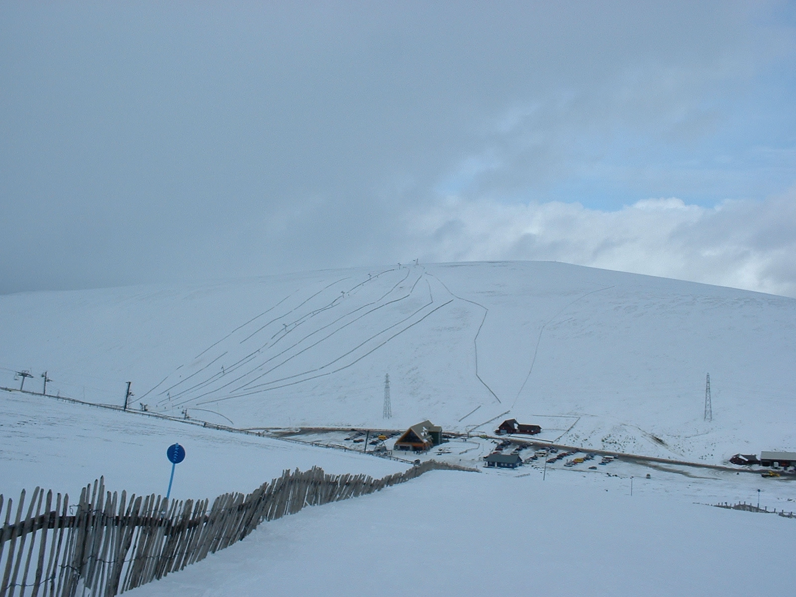
Lecht Ski Centre

The Lecht Ski Centre is an alpine ski area in the Cairngorms in the Scottish Highlands. The ski slopes are set around the mountains Beinn a' Chruinnich...

Corgarff

Corgarff (Scottish Gaelic: Corr Garaidh) is a hamlet in Aberdeenshire, Scotland, in the Grampian Mountains. The nearby Corgarff Castle was used as a military...

Nearby Amenities

Located within 500m of 57.158595,-3.2273937
Ordgarff
Ele: 507
Natural: peak
Lat/Long: 57.1584716/-3.2272332
The data included in this document is from www.openstreetmap.org. The data is made available under ODbL.

Have you been to Tom a' Gharraidh?

Leave your review of Tom a' Gharraidh below (or comments, questions and feedback).