Binsey

Hill, Mountain in Cumberland Allerdale

England

Binsey

The road by Marshall Cottage
The road by Marshall Cottage Credit: David Brown

Binsey is a small hill located in Cumberland, England. It is part of the Lake District National Park and stands at an elevation of 447 meters (1,467 feet) above sea level. Binsey is known for its picturesque and unspoiled natural beauty, attracting both locals and tourists alike.

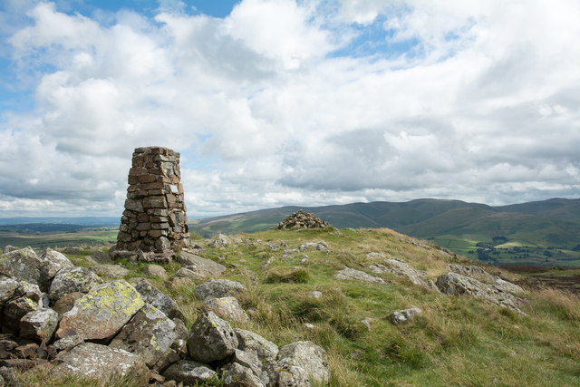
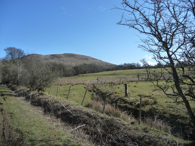
The hill is made up of a mixture of grassy slopes and rocky outcrops, offering stunning panoramic views of the surrounding countryside. On a clear day, visitors can see as far as the Solway Firth and the Scottish mountains to the north. The summit of Binsey is marked by a trig point, making it a popular spot for hikers and walkers.

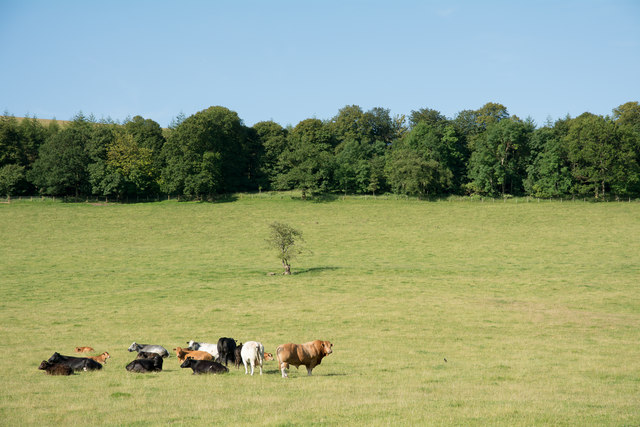
The area surrounding Binsey is rich in wildlife and biodiversity. The hill is home to a variety of plant species, including heather, bracken, and bilberry. It also provides a habitat for a range of bird species, such as skylarks, meadow pipits, and curlews. Binsey is a designated Site of Special Scientific Interest (SSSI) due to its ecological significance.

Access to Binsey is relatively easy, with a well-marked footpath leading to the summit. The hill can be reached from the nearby village of Bassenthwaite, which is approximately 5 kilometers (3 miles) away. The surrounding area offers ample opportunities for outdoor activities, including walking, hiking, and picnicking.

Overall, Binsey is a charming and tranquil hill in Cumberland, offering visitors a chance to immerse themselves in the beauty of the Lake District's natural landscape.

If you have any feedback on the listing, please let us know in the comments section below.

Binsey Images

Images are sourced within 2km of 54.708775/-3.2041799 or Grid Reference NY2235. Thanks to Geograph Open Source API. All images are credited.

The road by Marshall Cottage
Fell gate, Binsey
Fell gate, Binsey
Fellside Road
Fellside Road
The road towards Fell End
Binsey One of the northernmost fells in the Lake District National Park and the northernmost Wainwright summit, Binsey has an altitude of 447m (1466 feet) and stands isolated from the nearby fells.
There is an Ordnance Survey trigonometrical column on the summit (photograph <a href="https://www.geograph.org.uk/photo/7583609">NY2235 : Triangulation Pillar, Binsey</a>).
Binsey
One of the northernmost fells in the Lake District National Park and the northernmost Wainwright summit, Binsey has an altitude of 447m (1466 feet) and stands isolated from the nearby fells. There is an Ordnance Survey trigonometrical column on the summit (photograph NY2235 : Triangulation Pillar, Binsey).
Triangulation Pillar, Binsey The stone built Ordnance Survey triangulation pillar on the summit of Binsey. The village of Uldale is visible in the left background, the northern fells of the Lake District rise in the right background and the north Pennines form the far horizon.
The flush bracket benchmark number S5707 on the south-southwest face of the pillar marks a height of 447.446m above sea level (Ordnance Datum Newlyn) levelled in 1952 (detail photograph <a href="https://www.geograph.org.uk/photo/7584505">NY2235 : Benchmark, Binsey</a>).
The triangulation pillar is still in use as an Ordnance Survey passive GPS station.
Triangulation Pillar, Binsey
The stone built Ordnance Survey triangulation pillar on the summit of Binsey. The village of Uldale is visible in the left background, the northern fells of the Lake District rise in the right background and the north Pennines form the far horizon. The flush bracket benchmark number S5707 on the south-southwest face of the pillar marks a height of 447.446m above sea level (Ordnance Datum Newlyn) levelled in 1952 (detail photograph NY2235 : Benchmark, Binsey). The triangulation pillar is still in use as an Ordnance Survey passive GPS station.
Benchmark, Binsey Detail of Ordnance Survey flush bracket benchmark number S5707 on the south-southwest face of the triangulation pillar on the summit of Binsey.  The benchmark marks a height of 447.446m above mean sea level (Ordnance Datum Newlyn) levelled in June 1952 (location photograph <a href="https://www.geograph.org.uk/photo/7583609">NY2235 : Triangulation Pillar, Binsey</a>).
Benchmark, Binsey
Detail of Ordnance Survey flush bracket benchmark number S5707 on the south-southwest face of the triangulation pillar on the summit of Binsey. The benchmark marks a height of 447.446m above mean sea level (Ordnance Datum Newlyn) levelled in June 1952 (location photograph NY2235 : Triangulation Pillar, Binsey).
Direction Sign – Signpost near Uldale Located on the north side of a Y junction north of Whitefield Cottage in Ireby and Uldale parish. 3 arms and pawn finial. See also <a title="https://www.geograph.org.uk/photo/6578566" href="https://www.geograph.org.uk/photo/6578566">Link</a> and <span class="nowrap"><a title="http://www.geog.port.ac.uk/webmap/thelakes/photos/byh55.jpg" rel="nofollow ugc noopener" href="http://www.geog.port.ac.uk/webmap/thelakes/photos/byh55.jpg">Link</a><img style="margin-left:2px;" alt="External link" title="External link - shift click to open in new window" src="https://s1.geograph.org.uk/img/external.png" width="10" height="10"/></span>.

Milestone Society National ID: CU_NY2335
Direction Sign – Signpost near Uldale
Located on the north side of a Y junction north of Whitefield Cottage in Ireby and Uldale parish. 3 arms and pawn finial. See also Link and LinkExternal link. Milestone Society National ID: CU_NY2335
Bridleway rising through avenue of trees The bridleway rises north-west from  a minor road. It climbs the slope between Binsey and the low hill, Latrigg - not the one close to Keswick.
Bridleway rising through avenue of trees
The bridleway rises north-west from a minor road. It climbs the slope between Binsey and the low hill, Latrigg - not the one close to Keswick.
Bracken of eastern slope of Binsey An area of bracken covers the lower eastern slope of Binsey through which passes a footpath; that path rising from near Binsey Lodge is the most usual approach for the ascent of the hill. The small lake in view is Overwater and the hills beyond include Knott.
Bracken of eastern slope of Binsey
An area of bracken covers the lower eastern slope of Binsey through which passes a footpath; that path rising from near Binsey Lodge is the most usual approach for the ascent of the hill. The small lake in view is Overwater and the hills beyond include Knott.
Summit area of Binsey In addition to the trig point and cairn there's a shelter at the summit of this hill from beside which the photograph was taken. The highest of the distant peaks is Knott; other hills of the 'Northern Fells' surround it.
Summit area of Binsey
In addition to the trig point and cairn there's a shelter at the summit of this hill from beside which the photograph was taken. The highest of the distant peaks is Knott; other hills of the 'Northern Fells' surround it.
Fields with Skiddaw distant The fields lie south of a minor road close to Whitefield Cottage where a number of such roads come together just south-east of Binsey.
Fields with Skiddaw distant
The fields lie south of a minor road close to Whitefield Cottage where a number of such roads come together just south-east of Binsey.
Cattle with bull in field The field lies to the west of the minor road south of Ruthwaite.
Cattle with bull in field
The field lies to the west of the minor road south of Ruthwaite.
Road running west from Bewaldeth Heading towards Isel.
Road running west from Bewaldeth
Heading towards Isel.
Issue-fed tributary of Bewaldeth Beck The hill on the horizon is Binsey.
Issue-fed tributary of Bewaldeth Beck
The hill on the horizon is Binsey.
On Binsey Above Binsey's West Crag looking NW through early evening mist.
On Binsey
Above Binsey's West Crag looking NW through early evening mist.
Cairn on Binsey Binsey's summit is marked by a trig point; this cairn is nearby.
Cairn on Binsey
Binsey's summit is marked by a trig point; this cairn is nearby.
Road below Binsey The most commonly used path to ascend Binsey starts beside the road here.
Road below Binsey
The most commonly used path to ascend Binsey starts beside the road here.
Show me another place!

Binsey is located at Grid Ref: NY2235 (Lat: 54.708775, Lng: -3.2041799)

Administrative County: Cumbria

District: Allerdale

Police Authority: Cumbria

What 3 Words

///rejoins.spoiled.rats. Near Aspatria, Cumbria

Nearby Locations

Binsey Ireby and Uldale

Related Wikis

Binsey

Binsey is a hill on the northern edge of the Lake District in Cumbria, England. It is detached from the rest of the Lakeland hills, and thus provides a...

Bewaldeth and Snittlegarth

Bewaldeth and Snittlegarth is a civil parish in Cumbria, England, historically part of Cumberland. It lies north of Bassenthwaite Lake, in the Lake District...

Overwater Hall

Overwater Hall is a country house near Ireby in Cumbria. It is a Grade II Listed building. == History == The house was built for Joseph Gillbanks, who...

Uldale

Uldale is a small village and former civil parish in the Cumberland district, in the ceremonial county of Cumbria, England. It is about 5 miles (8 km)...

Over Water

Over Water is a small lake or tarn in the north of the English Lake District, southwest of the hamlet of Longlands. Binsey, Great Cockup and Longlands...

Ireby and Uldale

Ireby and Uldale is a civil parish in the English county of Cumbria forming part of the district of Allerdale. The population, including Bewaldeth and...

Bassenfell Manor

Bassenfell Manor is a manor house in Bassenthwaite, Cumbria, overlooking Bassenthwaite Lake in England's Lake District. It is used as a Christian residential...

Bassenthwaite

Bassenthwaite is a village and civil parish to the west of Bassenthwaite Lake in Cumbria, historically part of Cumberland, within the Lake District National...

Nearby Amenities

Located within 500m of 54.708775,-3.2041799
Description: OS trig pillar
Ele: 447.4
Man Made: survey_point
Note: Accurate location import for imagery offset calibration. Please do not move.
Ref: S5707
Source: Ordnance Survey (OGL)
Survey Point: pillar
Tpuk Ref: TP0690
Lat/Long: 54.7087865/-3.2041845
Binsey
Ele: 447
Natural: peak
Ref: S5707
Source: Ordnance Survey (OGL);https://www.hill-bagging.co.uk/mountaindetails.php?qu=S&rf=2351
Wikidata: Q4914510
Wikimedia Commons: File:Binsey summit - geograph.org.uk - 986418.jpg
Wikipedia: en:Binsey
Lat/Long: 54.7087977/-3.2041911
Man Made: cairn
Lat/Long: 54.7094617/-3.2057148
The data included in this document is from www.openstreetmap.org. The data is made available under ODbL.

Have you been to Binsey?

Leave your review of Binsey below (or comments, questions and feedback).